The pretext for this book is the 25th annual meeting of the Society for the Study of Architecture in Canada, in Toronto. The book’s context is a bit different.
All academic conclaves require leavening. Normally, this involves at the very least a wine-and-cheese “meeter and greeter” to catch the early registrants, a licensed “banquet”, and some time for conferees to wander off and sample the local trinket shops. But the SSAC moves its conferences to different locales each year so that the place itself becomes part of the conference. Thus, tours of the host city or town are meant to be integral to the conference rather than escapes. This is a good and important feature of the meetings, but there is the risk that by the end of the day the participants may be more exhausted than edified.
This little book was conceived to restore something of the “escape” function to the time outside of the conference theatre. Think of these essays and pictures as the guided tours that would have extended the conference by another week. And thus, this contribution to the conference becomes a legacy from the conference.
While conceived as a presentation about the conference’s theme – “Fresh perspectives on housing” – this book is a really a selective and fragmented guide to locations and locales, presented in personal ways by a host of contributors. It has been a long time since a single voice could speak to the diversity and complexity of the centre of Toronto. This is a central city in the midst of a big city of almost two and a half million people, in the midst of a region of at least four million, and (according to some accounts) the anchor of a conurbation of more than eight million in two countries.
So we give you many takes, some very opinionated, on the housing of people in the midst of the city, viewed historically, geographically and architecturally. In the usual guided tour, one person holds a megaphone and tells stories to whomever is within earshot. In this tour, the mega-phone is turned around, and sixty-five or so people are talking to one person – you, the reader.
The book is a presentation – more precisely a re-presentation – of a selection of buildings and sites and stories about living in the centre what was once described proudly – almost precisely 25 years ago – as a “city that works”. You remember, don’t you? The cover of Time magazine and all that?
Well, be assured that the city still does work. Like all cities, it works as well as it can.
Yet Toronto – a single entity embracing what had been six, and before that thirteen, and before that, dozens of towns, villages and townships – remains self-conscious and uncomfortable about how its image has withdrawn into the middle ranks of world cities since those euphoric 1970s. (The rest of Canada still doesn’t like Toronto much; that at least hasn’t changed.) The Toronto of 2000 faces crises of transportation capacity, social services and affordable housing. The well-managed halo of three decades ago has slipped. Indeed, the halo may have been yanked off altogether, whether by circumstance or more deliberate machination we dare not say.
Well (again), some of the brief commentaries in this book do say. On one side, there are new and fascinating places to live, renewed and revived neighbourhoods, and major efforts in research and planning for projects large and small. On another side, there are growing arguments for increased political autonomy for the city.
But on another side, there are people who have no fixed address.
In this book we look at east and west sides of “downtown.” Until the expressway constructions of the 1950s, the map of built-up Toronto and its environs looked very clearly like an inverted T, hugging the shore of Lake Ontario, with Yonge Street its spine. Now that much of the rest is filled in, that central spine is no longer such a defining feature. So, to call this book East/West is fairly subtle (as well as a bit nostalgic). The subtlety is that street numbers in Toronto – even to the outer reaches of what people will still be calling Etobicoke and Scarborough for a very long time – start at the middle, at Yonge Street. In the middle of the centre of the city, the east side was developed and inhabited slightly before the west side, so East/West is chronologically valid. But on maps, the city reads left to right, thus West/East. (Attentive readers may find the title swapped around as often as not.)
Toronto is, after all, constructed on a mostly rectilinear grid of property subdivisions. One street is pretty much like another, so they say. Streets are usually straight, house lots are usually rectangles. What the preface calls cross-sections – what geographers and surveyors call transects – go north to south on both east and west. It’s easy enough to navigate.
There are nonetheless several cautions for the visitor who wishes to walk, cycle, skate or drive these “routes.” The “calming” of vehicular traffic is well established in predominantly residential areas. Many streets are one-way, and in the more assertive neighbourhoods they are almost no-way. Parking-meter rates and by-law enforcement have lately become more irritating, even during the brief time this book has been under construction. Pedestrians and other sidewalk users must contend with either frequent street crossings or long detours (cycling on sidewalks is for small children only, and there is still no consensus on where rollerbladers should be flying). So it’s not so easy enough to navigate after all. Bring a map, and bring patience.
Throughout this book, and throughout Toronto’s history, are case studies of exigency – mostly about making do under the pressure of existing conditions, with very rare (heroic?) attempts to overcome those conditions. Quite unlike Manhattan or other well-known examples of the parceling of land, the Toronto grid is in truth a set of nested grids. Just like those nested Russian dolls.
The original colonial survey comprised farm lots with roads almost a kilometre and half apart (100 surveyor’s chains, or 6600 feet, to be more precise), and within each big square of this grid, 10 or 20 rectangular lots to be doled out or sold. Over two centuries, each of these big lots has been subdivided and subdivided and further subdivided, and none of the resulting properties nor even most of the roads were created or built on by government. The map of Toronto may be among the proudest expressions of 19th-century laissez-faire capitalism on the continent.
Roads that don’t quite align, blocked or misdirected views, surprisingly wide boulevards, improbably narrow lanes – all these are part and parcel of the city’s parts and parcels. Even University Avenue, the city’s grand urban boulevard, is an accident of property ownership: there was a city street parallel to one of the University of Toronto’s driveways, and the two were “assembled” only after many decades of inconvenience.
The oh-so-rare exceptions – the generous street allowances of parts of Spadina Avenue, and College and Queen streets – were private contributions to the urban landscape, from the beginning.
This leads directly to the theme of our little guide, the actual housing of people on these parts and parcels, these long straight streets and narrow lots. The neighbourhoods, blocks of houses, individual houses, and on down to their narrow yards and small rooms (pace Rosedale and Wychwood Park) – all follow from previous generations of subdivision. For that matter, so do their building forms and architectural styles, even the avowedly modernistic. All are adaptations. Even the most inventive – and there are many of these, when you look carefully – are founded on precedents, and they often look side-long at their neighbours.
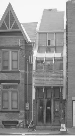
This house, ![]() , constructed on an eight-foot wide lot with an interior as wide inside as a normal residential door is high, may well be the most exigent example in the book, old or new. It was a neighbour and contemporary of one of those “Toronto residences” of 1934 shown at the very beginning of this book, though most of what you see now is a vertical addition of the 1970s. The architect/renovator went ahead with the conceit of expanding the narrow house even though he had acquired the 20-foot wide lot next door. This house is unusual, to be sure, but no less adventurous adaptations have come to exist throughout many older neighbourhoods, distracting us from what might have well been very homogeneous architecture and streetscape in their formative years.
, constructed on an eight-foot wide lot with an interior as wide inside as a normal residential door is high, may well be the most exigent example in the book, old or new. It was a neighbour and contemporary of one of those “Toronto residences” of 1934 shown at the very beginning of this book, though most of what you see now is a vertical addition of the 1970s. The architect/renovator went ahead with the conceit of expanding the narrow house even though he had acquired the 20-foot wide lot next door. This house is unusual, to be sure, but no less adventurous adaptations have come to exist throughout many older neighbourhoods, distracting us from what might have well been very homogeneous architecture and streetscape in their formative years.
Such “marginal” cases give historic-district planners riotous nightmares – what does “integrity” or “authenticity” mean in such neighbourhoods? Perhaps “integrity” might actually be the opposite of “interest”?
(The house is not mapped, but it should not be so hard to find.)
The exceptions to this general rule of exigency and adaptation are easy to spot: they comprise attempts to change the property lines. Land assembly – sometimes called blockbusting or urban renewal or even (more recently) urban regeneration – is the courageous attempt to reverse the historic course of progressively smaller increments of ownership and control. Land assembly is heroic because it is expensive – in terms of money and disruption – even on what might appear to be the poorest and cheapest lands.
The development of Regent Park, Moss Park, and Alexandra Park (public); or St James Town (private); or Harbourfront (confusing); or the West Don Lands/Ataratiri (failed) are all efforts at city rebuilding that erase and replace the texture of the city. Some of these erasures have proven successful over time, but it must be clear to even the blockbuster that the construction of new environments is not a science. Yet, the St Lawrence neighbourhood seems to be a successful – yes, livable – large-scale urban re-do. So, is it a coincidence that its overall pattern follows what had been the existing street plan, and that what became its central Crombie Park is evident in city maps of the late 19th century? Were its planners just lucky? Were the planners of St James Town or the central waterfront just unlucky?
In reading the streets and houses of central Toronto, what is evident on close inspection is the malleability of housing in a “traditional” neighbourhood over time, in terms of form, tenure, scale, even cost. In some respects this is a result of time; that is, over many decades there are many individual responses, and these are both cumulative and variable (with changing technology and fashion). Neo-traditional, “new urbanist” developments try to capture this image. Such projects are mostly missing from this edition (though, see Castle Hill, p 82, and the innards of the older blocks of the St Lawrence neighbourhood, p 68). This new “planning style” is quite conspicuous near the neighbourhood of the Candy Factory, p 153, or at the former old Woodbine/Greenwood racetrack east of the Don River.
Such tracts tend to look very impersonal in their early years. Will they acquire the casual and varied character of the “typical” Toronto neighbourhoods, like the Annex or Sussex-Ulster or Cabbagetown in the very long term? Or does some factor of uniform construction, or density, or by-law strictures, or lack of non-residential land use preempt or impair such an evolution? Time will tell – particularly whether the new-urbanist style is able to help the establishment of “neighbourhood-ness” in this traditional sense. Portions of some neighbourhoods in this guide – Cabbagetown, for instance – did not reach the form we see today (more or less) for several decades. Others – many streets in Sussex-Ulster, for instance – were almost completely built up within a very few years in the 1880s.
Despite the variety of both subject matter and author, we have missed or passed over several more guidebooks’ worth of lessons on urban housing in Toronto. For instance, we have not called attention to the quintessential high-density mixed-use pioneer – the Colonnade – as well as to the march of high-density residences north up Bay Street from Dundas, all in the image of the Colonnade, but far less impressive in quality than in quantity.
We haven’t shown the quirkily modern pioneering live-work block at 477 Richmond West, though we have included several recent or impending “loft” projects, which are also less impressive in quality than in quantity.
We have passed over many examples of special-needs housing for seniors, or for the physically or psychically frail. We have not shown you what “modern” rooming-house conditions look like. We have not presented some of the physical solutions to the problems of poor or no housing for the economically or socially disadvantaged, like the Street City initiatives. At the other end, we haven’t given you much of a look at those Georgianesque condos of the ’90s, already quaintly dated, which may well become the middle-class housing of the upcoming ’10s. We were overwhelmed by all the lofts. Sorry.
The planning and construction of housing – indeed, the planning and construction of whole neighbourhoods and entire cities – are at least as much (or more?) art, craft and politics as they are engineering, efficiency, and “common sense.” Look closely at the places we propose, and at their neighbours as well.
It is both frustrating and refreshing to know that our predecessors (even in the 19th century) have grappled with problems of resources and techniques and politics no less difficult than the problems of our contemporaries – and that their tools and their solutions were just as reliable and no less likely to make good dwellings and good neighbourhoods. And we can still benefit from experience in other fields.
Dr Gibbel of Lion Oil Electronics United addressed the stock holders, describing a new ‘surprise’ computer. After complex pre-programming by a team who does not know the computer’s ultimate use, it is leased to someone who does not know the pre-programming routines.
‘Ultimately,’ he said, ‘and without warning, the computer may do something either very stupid or very shrewd.’
So it may be for houses and neighbourhoods – and cities, too.
Mark Fram