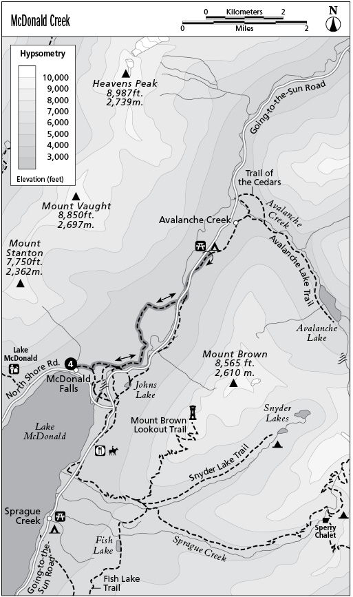
4 McDonald Creek
Type of hike: Out-and-back
Total distance: 6.8 miles (10.9 km) round-trip
Time required: 3 to 5 hours
Elevation change: 200-foot gain
Finding the trailhead: From Lake McDonald Lodge, follow Going-to-the-Sun Road northeast for 0.5 mile to the junction with the North Shore Road. Turn left, crossing the bridge over McDonald Creek to reach the marked trailhead on the right side of the road.
The Hike
This short hike follows a fragment of the old packers’ trail that ran up the McDonald Creek Valley before Going-to-the-Sun Road was built. Here McDonald Creek is guarded by the low walls of a distinctive little gorge; its aquamarine waters flow down as rushing waterfalls and quiet runs. Part of the trail is used for trail rides originating at Lake McDonald Lodge, so be prepared to meet horses along the way. The hike is particularly striking in the silence of early winter, when massive icicles hang from the walls of the gorge.
The trail begins by wandering northwest through a mixed woodland of hemlock, larch, and Douglas fir occupying the bottomlands along McDonald Creek. After a short journey, the path approaches the stream, with its turquoise waters swirling down between slanted slabs of stone. To view the roaring cataract of McDonald Falls, take a short side trip down the stream bank on an unofficial trail marked with a sign saying NO HORSES. The main path now runs northeast along the rim of a small gorge. The crenelated façade of Mount Brown looms across the valley, a constant presence along this portion of the route. The path soon reaches the sturdy bridge over Sacred Dancing Cascade, and just upstream the water descends gracefully across a lengthy series of tiny stairsteps.
The wider path leads across the stream to a parking area and beyond to Johns Lake; the narrow gravel pathway, McDonald Creek Trail, continues upstream along the north bank of the creek. After passing a small waterfall, the trail turns inland to enter the silent hallways of climax coniferous forest. Where it next emerges, streamside, the waters glide placidly through cedar bottoms. The lofty edifice of Mount Cannon rises ahead, and soon Mount Vaught and Heavens Peak appear on the north side of the valley. Watch for moose as well as beaver, which have dammed some of the slow-moving backwaters in this area.
The path then wanders inland, passing through a deep forest of hemlock. At mile 2.2 the horse tours turn around at a wide spot in the timber. A more primitive path continues onward, becoming overgrown with low brush for a short stretch. It soon crosses a gravelly wash where floodwaters from the slopes of Mount Vaught have buried the tree trunks in rocky debris. On the far side of the stream course, the path improves for a long sojourn through hemlock forest. Travelers are rewarded as the trail emerges beside the rocky upper gorge of McDonald Creek. Here, waters churn over violent waterfalls, and the imposing summit of Mount Cannon rises regally above the stream. Watch your step; there are no guardrails here to prevent a tumble into the churning white water. The path ends suddenly atop the bedrock with views of a particularly impressive falls.
Key Points
0.0 Start at North Shore Road.
0.9 Bridge over McDonald Creek. Stay on north bank of creek.
2.2 Horse turnaround point.
3.4 Trail ends at edge of gorge. Turn around and return to trailhead.
6.8 Arrive back at trailhead.