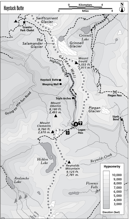
8 Haystack Butte
Type of hike: Out-and-back
Total distance: 6.8 miles (10.9 km) round-trip
Time required: 3 to 6 hours
Elevation change: 600-foot gain, 200-foot loss
Finding the trailhead: The trail begins at Logan Pass, across the highway from the visitor center.
The Hike
This section of the Highline Trail is one of the most popular hikes in the park, owing to its spectacular vistas, excellent wildlife-viewing opportunities, and low level of difficulty. Due to the crowded nature of this trail and the slow decomposition of human waste at high elevations, please use the restroom facilities at Logan Pass before setting out.
The trail follows the west face of the Continental Divide, maintaining a relatively constant elevation. The Highline Trail crosses excellent habitat for many types of wildlife, and the open subalpine meadows of the Garden Wall allow easy viewing of wild creatures in their natural environments. Columbia ground squirrels abound in the alpine tundra, and hoary marmots and pikas live among the boulders of talus slopes. Look for mountain goats and bighorn sheep near the bases of the cliffs and among stands of fir. Raptors often soar on thermals high above the alpine meadows, hunting for rodents. Please do not feed the wildlife, in the interest of keeping it wild.
The trail begins at Logan Pass, winding through twisted forms of subalpine firs and Engelmann spruce. Strong winter winds blow ice particles that tear the branches from the windward side of the trees, giving them a flaglike appearance. In areas of especially high wind, all exposed branches may be pruned by windblown ice, creating a low, matlike growth form called krummholz in adult spruce and firs. Watch for mountain goats here.
After several hundred yards, the trail winds around a sheer cliff face, high above the valley below. There is a cable handrail for nervous travelers. The trail then continues northward through open stands of fir, following in the shadow of the Garden Wall. This landform was created by the action of glaciers moving down valleys on both sides of a mountain mass. The resulting knife-edge ridge is called an arête. Winter avalanches hurtle down from its heights on a regular basis, clearing broad swaths in the trees and shrubs. Across the valley, Mounts Oberlin, Clements, and Cannon cradle a hanging basin, formed by glaciers, from which Bird Woman Falls cascades almost 500 feet to the valley floor.
The path soon levels off for a long stretch, proceeding northward beneath the towering cliffs. Views now expand to include Heavens Peak to the northwest, and soon there are views of the rest of the Livingston Range stretching away into Canada. The trail ultimately emerges into an open bowl clad in tundra. Beargrass and other wildflowers bloom here beside slender rills and stairstep cascades. The trail climbs gently to the pass behind Haystack Butte, a rounded promontory that juts into the Logan Creek Valley. Golden-mantled ground squirrels, identified by the alternating stripes of black and blond on their backs, inhabit the slopes around Haystack Butte. From here there are fine views southward to Logan Pass, with Reynolds Mountain presiding over it and a slender skein of water descending into the valley below. This is the turnaround point, and it makes an ideal lunch spot. Huge boulders have fallen into the saddle from the cliffs above; rest on a rock to avoid damaging the fragile vegetation.
Key Points
0.0 Start at Logan Pass.
3.4 Saddle behind Haystack Butte. Turn around and return the way you came.
6.8 Arrive back at trailhead.