9 St. Mary and Virginia Falls
Type of hike: Out-and-back
Total distance: 2.4 miles (3.9 km) round-trip to St. Mary Falls; 3.6 miles (5.8 km) round-trip to Virginia Falls
Time required: 1.5 to 3.5 hours, depending on destination
Elevation change: 285-foot gain, 260-foot loss
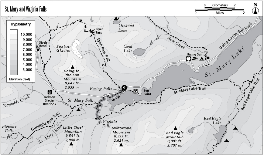
Finding the trailhead: The trailhead is located on Going-to-the-Sun Road, about 0.3 mile west of Baring Creek.
The Hike
This trail is a short and pleasant stroll through sun-dappled forest to several roaring waterfalls in the valley below Going-to-the-Sun Road. From the trailhead, the trail descends to the valley floor, past well-marked trail junctions, to cross the river immediately below the thundering cataract of St. Mary Falls. Beyond the falls the forest opens up, affording views of Little Chief and Dusty Star Mountains. The path winds around the ends of several hillocks to reach Virginia Creek, which it follows for 0.5 mile past a narrow gorge. The hike ends at equally impressive Virginia Falls, which emerges from the mouth of a hanging valley. A short spur on the right leads you to the foot of the falls.
Key Points
0.0 Start at trail sign. Trail descends toward the St. Mary River.
0.3 Junction with the Siyeh Pass Trail to Piegan Pass. Turn right for St. Mary Falls and Virginia Falls.
0.7 Junction between St. Mary Lake trail and the connecting trail to Gunsight Pass. Turn left for falls.
1.2 Trail crosses St. Mary River at St. Mary Falls. Trail continues, ascending the south side of the St. Mary Valley.
1.8 Virginia Falls. Return the way you came.
3.6 Arrive back at trailhead.