15 Aster Park
Type of hike: Out-and-back
Total distance: 3.8 miles (6.1 km) round-trip
Time required: 2 to 4 hours
Elevation change: 440-foot gain
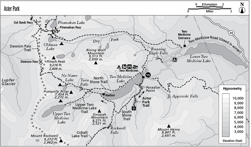
Finding the trailhead: The hike begins at the Two Medicine Lake South Shore Trailhead, located at the west end of the Two Medicine lower boat dock parking lot.
The Hike
This route combines the early reaches of the Two Medicine Loop with a spur trail that visits a pretty waterfall and then climbs to a high overlook above Two Medicine Lake.
The hike begins by climbing gently into subalpine forest south of Two Medicine Lake. At the top of the rise is a trail junction, where a spur path descends to Paradise Point on the lakeshore. The main trail wanders inland, passing stagnant wetlands; open meadows beside the marshes offer outstanding views of Appistoki Peak and Never Laughs Mountain to the south, Sinopah Mountain above the head of the lake, and Rising Wolf Mountain beyond the far shore. A footbridge leads across Aster Creek, and on the far bank is the junction with the Aster Park Trail.
Turn left as this spur trail rises gently through the pines and firs. Soon a side path splits away toward the base of Aster Falls, where Aster Creek sluices down through a cleft in the bedrock, arcing downward in ribbonlike streams. The main trail makes several upward switchbacks, then settles into a steady westward grade through the trees. At the top of a low headwall, hikers will get fine aerial views of Two Medicine Lake and the surrounding crags. The trail then turns south into the hanging valley of Aster Creek before climbing to its end on a rocky overlook at the edge of the Two Medicine Valley.
Key Points
0.0 Start at South Shore Trailhead.
0.2 Junction with Paradise Point spur (0.4 mile). Bear left for Aster Park.
1.2 Junction with Aster Park Trail. Turn left.
1.3 Spur trail to base of Aster Falls.
1.9 Aster Park Overlook. Turn around and return the way you came.
3.8 Arrive back at trailhead.