Chapter 5
Applications
A number of fields will benefit from a dual GPS/Galileo receiver combined with other technologies. This chapter briefly introduces some of the fields and aspects that will be positively impacted by this device. Once the RF front-end has been verified, a system should be developed to check whether the designed RF front-end works for a specific application. To gauge the performance of the front-end within a receiver, a full-solution platform is required. Therefore, to integrate the design example of this book, the development of a navigation module for the automotive industry is given as an example. This not only allows for the verification of the receiver in a static case by mimicking the conditions of lab measurements, but also for that of the front-end in a high-speed and dynamic environment.
A complete Global Navigation Satellite System (GNSS) receiver is composed of the analogue element (antenna and RF front-end), digital signal processing, which obtains the information coming from the receivers; and map-managing and user interface hardware and software. Apart from the selected antenna and the RF front-end developed in this book, a commercial processor has been selected to set the coordinates using navigational data. Then, an on-board PC and a LCD screen suitable for car use for the receiver has been chosen and a software has been developed to acquire navigational data and manage maps.
5.1 Fields of Application
GPS/Galileo-based applications can be found on land, on water, and in the air. The system can be employed wherever satellite signals can reach the end user's receiver. This, of course, is not the case where it is impossible to receive signals, such as inside buildings or within subterranean or submarine locations, among other locations.
The most common air applications are for navigation by general aviation and commercial aircraft. It is also typically used for navigation by recreational boaters, commercial fishermen, and professional mariners. The scientific community also employs precision timing capability and position information. Surveyors save money by drastically reducing setup time at the survey site and providing highly accurate measurements. Recreational uses, which are as numerous as recreational activities themselves, will benefit from improvements in satellite navigation where location, position tracking, or direction plays an important role.
Several applications that can take advantage of the GPS/Galileo receiver together with the use of other technologies are listed as follows [EU-Galileo]:
 Road The road sector is a major potential market for satellite navigation-based applications, since they are already commonly installed in new cars as a key tool for providing new services to people on the move. These include electronic charging, real-time traffic information, emergency calls, route guidance, fleet management, and Advanced Driving Assistance Systems (ADAS). Apart from these features, drivers, car manufacturers, and law enforcement officials can benefit from the increased availability of satellite navigation services in advanced car navigation systems. They can also reap the rewards of reduced travel time, demand management, and traffic monitoring and increased confidence in fleet management and tracking of goods in all industry sectors.
 Rail A number of rail transport applications—ranging from traffic, wagon, and cargo control and monitoring to train signalling, track survey, and passenger information services—will be offered, making it possible to reduce distances between trains and therefore increase train frequency. In addition, such applications will make it easier to locate the entire rail fleet. These applications will increase rail transport performance and facilitate a massive transport shift from road to rail, reduce trackside equipment, and provide additional economic benefits for train control. Furthermore, the benefits of high positioning accuracy for efficient track surveying, a unique tool that contributes to a number of different functions, are bound to be significant.
 Aviation Satellite navigation has already been used as an additional means of localisation, which helps many aspects of aviation in both commercial and noncommercial air transport alike. Ground movement, taking off, en-route flying, and landing in all weather conditions will reach the required level of safety necessary to cope with the continuous increase in flights. Air traffic management will be optimised for rapidly growing air traffic, and airport infrastructures will be able to guarantee better traffic control and safety, which will be increased by means of system redundancy between GPS and Galileo. The benefits offered to the aviation community will include the following: increased safety through an additional independent satellite constellation with no common modes of failure, a navigation system built to aeronautical safety requirements, high system performance to complement ground infrastructure, increased safety of navigation in all flight phases, increased efficiency in flight operations management, improved airspace utilisation, and safer navigation of rescue helicopters under all weather conditions.
 Public transport Traffic congestion, pollution, and other negative aspects will be reduced with the optimisation of public transport. The public transport sector can benefit from improved services and lower costs, efficient fleet usage with better coverage of different urban zones, increased driver security, new solutions for car pooling, and improved car navigation systems.
 Maritime Innovation and progress will be brought to navigation and activities such as fishing, oceanography, and oil and gas exploitation in order to increase the efficiency, safety, and optimisation of marine transportation. All marine applications, including recreational boats, commercial vessels, and unregulated and safety of life at sea (SOLAS)–regulated ships will benefit from a reliable, safe, and accurate tool for maritime navigation in any phase. In addition, integrity information for Safety-of-Life and improved search and rescue (SAR) services will see significant benefits.
 Safety Risks for travellers and working crews will be reduced and lives will be saved through increased route guidance capabilities and advanced driver assistance systems. Other benefits include better air traffic management, more reliable positioning information for trains and boats, better fleet management and en-route guidance of emergency services, effective tracking of dangerous or valuable goods during their transportation, and more effective monitoring of infrastructures.
 Energy Improvement will also be seen when it comes to the control of energy infrastructures. These benefits include improved power flow, enhanced time-synchronisation of power-related instruments, increased safety and efficiency in oil exploration, improved control of drilling facilities, and faster positioning information, even in remote areas.
 Telecommunications A synergy between satellite-navigation applications and telecommunications will increase the level of communications and the efficiency of their networks. For example, receivers with mobile phones will generate a multitude of combined uses for the making of emergency calls (E-112 in Europe, E-911 in the United States) or for new services based on location, direction, or real-time traffic information, among others. This will provide a precise and low-cost tool for network synchronisation, ensure the stability of synchronisation, increase communication traffic via Location Based Services (LBS), offer customised services to clients, and increase pricing and billing flexibility.
 Finance, banking, and insurance The digital lifestyle that so many of us lead requires the transmission of sensitive data every day. Therefore, security, data integrity, authenticity, and confidentiality have emerged as major issues in the electronic exchange of documents. The protection of such information is vital, and the latest encryption and authentication techniques are ever-evolving. The following will be offered: a common, validated time reference at low cost; availability of advanced and simple security modules for low-cost encryption; simple and secure transactions with easily authenticated electronic documents and data; a secure tool for e-commerce applications; satisfied insurance companies and users; and fewer risks in highly sensitive operations.
 Civil engineering This field, which relies on accuracy and reliability, will benefit from decreasing costs and increasing efficiency. Combined with digital mapping, a powerful tool for improving productivity will be offered, spanning the planning of structures to the maintenance and surveillance of existing construction projects. Together with other technologies, GPS/Galileo technology will make it possible to improve logistics and optimise human resources, which will lead to increased efficiency with no loss in quality and increased safety on the construction site.
 Agriculture Food security issues will be managed in a more efficient way to overcome consumer concerns. The quality of agriculture will improve while respecting the environment. Together with other technologies, GPS/Galileo technology will help minimise the distribution and dilution of chemicals, improve parcel yield from customised treatment, and lead to more efficient property management.
 Fisheries The needs of the fishing sector range from day-to-day operational support to the navigation and positioning of fishing vessels. Strict international rules governing intrusion into national waters demand that vessels are monitored to ensure that they fish only within designated areas. It will be possible to obtain a more effective exchange of information between vessels and stations, improve fishing capabilities, and enhance navigational aids for fishermen.
 People with disabilities A key benefit of these kinds of applications and services is to provide technological assistance for people with disabilities in a variety of situations, by increasing the availability of support services, especially in inner-city areas. Some application examples may include personal navigation assistance for people with impaired vision; assistance for Alzheimer's patients with memory loss; route planning for people with physical disabilities; enhancement of telemedicine or emergency services through real-time localisation; and real-time public transport audio announcements regarding remaining travel time, stops, and connections.
 Civil protection Disaster management will reap significant benefits as additional lives will be saved thanks to a space-based system with global coverage and round-the-clock availability, reliable positioning, and optimisation of rescue operations and resources. These will be available in difficult environments and even when local infrastructures and services may be temporarily unavailable.
 Time reference Not only is the high accuracy time disseminated by the modern GPS and Galileo advantageous, but so is the technology's interoperability with applications that require a common time reference. Examples include wireless telecommunication network management or power plant and network monitoring. Moreover, applications that require certified time stamps will also benefit, such as electronic banking, e-commerce, the stock exchange, and quality assurance systems and services. Other applications may include traffic light regulation, certified documentation production, and so on.
 Science An improvement to data collection in the area of environment monitoring will aid in the analysis of polluted areas; studies of tides, currents, and sea levels; tracking of icebergs; and the study of tectonic movements. An improved instrument capable of continuously tracking wild animals will be crucial in the study of biology and animal behaviour. A miniaturised receiver can be attached with a collar to monitored or protected animals to follow the movement and migration of species that might be in danger. This is important for the study of behaviour and for the monitoring and preservation of habitats.
 Leisure Apart its use in recreational flying or boating, a navigator for amateur users will provide personal information by means of handheld terminals combined with a map display and with secondary communication functions integrated with mobile communication technology. In this area, the key difference between the actual receivers and the ones allowing to integrate other communications technologies, is its focus on interoperability issues, which easily allow for integration (at the system and user level) with other existing and future systems (Global System for Mobile Communications [GSM], Universal Mobile Telecommunications System [UMTS], etc.).
5.2 Application Module for Cars
GPS/Galileo navigators will be commonplace in automobiles as well. Some basic GPS systems are already in use and offer emergency roadside assistance with just the push of a button, by transmitting the car's current position to a centre station. More advanced systems even show the car's position on a street map. Currently these kinds of systems allow any driver to know his or her position and even recommend the best route to reach the driver's destination. This section shows the development of such a navigation car module, which consists of a receiver module combined with the RF front-end design example described in this book and a navigation module.
5.2.1 Receiver
A GNSS receiver is able to pinpoint the position of the user from the signal sent by satellites. The navigation data are received by the antenna, down-converted by the RF front-end, digitalised in the analogue-to-digital converter (ADC), and correlated and processed by the processor in order to obtain the Position Velocity and Time (PVT).
Chapter 2 explained acquisition, down-conversion, and digitalisation. These are the main functions of the RF front-end. However, a processor is required to complete a receiver. The digital part of the receiver consists of a correlation digital signal processing (DSP), responsible for the demodulation of the signal, and a central processing unit (CPU) that processes the information sent by satellites.
The correlation consists of a demodulation of the signal with the respective satellite code. However, the received signal usually presents a delay in phase, as well as in frequency, compared to the original signal. Thus, the PR code has to be modified in phase and frequency to adapt it to the received signal.
Some devices are able to process 12 channels in parallel, managing all 12 respective PR codes in unison. In this case, receiver complexity increases, but performance is improved. Four satellites are enough to obtain the receiver's position, and redundant information is obtained to correct errors in accuracy. Moreover, when a satellite is out of view, the code for the next satellite in view can be calculated, decreasing the needed correlation time.
The demodulated signal is then processed in the CPU in order to obtain the receiver's position. Afterwards, the information is processed to be sent to the interface of the user. Therefore, a processor is required to combine a complete receiver with the front-end of this project. To make it suitable to the designed RF front-end and ensure optimised receiver performance, you must consider the following key criteria when selecting the processor:
 Highly integrated single solution: processor and correlation DSP in one chip
 High number of processed channels
 3.3V voltage supply
 Low power consumption
 Small size
 Short time to first fix (TTFF)
 Clock frequency of 16.368MHz
 1bit input signal
The GPS processor ST20GP6 [STGipsy], which fulfills the aforementioned requirements, has been selected. The data input is serial 1bit data, the clock frequency is 16.368MHz, and the power supply is 3.3V, making it suitable for the RF front-end. It integrates a 12-channel GPS correlation DSP, a CPU with microcontroller style peripherals, static random access memory (SRAM), read-only memory (ROM), and so on. The navigation data output is implemented through the serial port (RS232).
The receiver will be made up of the ST20GP6 [STGipsy] and the design example RF front-end of this book. The GPS signal will be received by the antenna, down-converted, and digitalised by the front-end. Then the digital element will process the signal to get the PVT information. The receiver diagram is shown in Figure 5-1.
5.2.2 GPS Processor
The ST20GP6 [STGipsy] is an application-specific single-chip micro using the ST20 CPU with microcontroller-style peripherals added on-chip. It incorporates DSP hardware for processing signals from GPS satellites. The 12-channel GPS correlation DSP hardware is designed to handle 12 satellites, two of which can be initialised to support the RTCA-SC159 specification for the Wide Area Augmentation Service (WAAS) and European Geostationary Navigation Overlay System (EGNOS) services.
Designed to minimise system costs and reduce the complexity of GPS systems, the ST20GP6 [STGipsy] offers all the required digital functions on one chip, including 64 KBytes of SRAM and 128KBytes of mask ROM. It supports large values of frequency offset, allowing the use of a low-cost oscillator while maintaining excellent TTFF performance. The CPU and software have access to the part-processed signal to enable accelerated acquisition time.
The ST20GP6 [STGipsy] can implement GPS digital signal processing algorithms using less than 50 percent of the available CPU
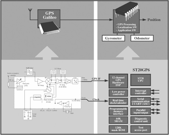
Figure 5-1 GPS receiver
processing power. This leaves the rest available for integrating original equipment manufacturer (OEM) application functions such as route finding, map display, and telemetry. Other characteristics are shown in this list.
 32bit ST20 CPU
 2-channel GPS correlation DSP
 64Kbytes on-chip SRAM
 128Kbytes mask ROM
 Programmable memory interface
 Serial communications
 Vectored interrupt subsystem
 Power management
 3.3V, 0.35µm CMOS technology
 Diagnostic control unit
 JTAG test access port
 PQFP100 package
5.2.3 Navigator
The GPS receiver has been integrated into a system to provide a user-friendly interface. The navigator structure is a simple modular structure, as shown in Figure 5-2. It is basically composed of the GPS receiver, a PC, and a screen. The core of the architecture is an industrial PC, which allows the interconnection of all the basic elements of the system as well as other components that improve the features of the navigator.
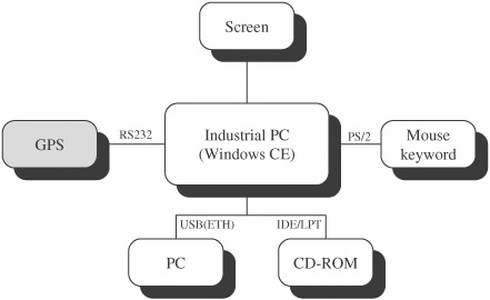
Figure 5-2 Navigation module block diagram
Navigation software has been developed enabling the PC to connect to the GPS, obtain information, and provide the user with coordinates on a graphical interface.
The navigator prototype is shown in Figure 5-3. The receiver, PC, and screen are integrated within a single module suitable for the dashboard of a car. The touchscreen protrudes slightly from the module, hiding the rest of the electronics. Moreover, as explained previously, other applications can be connected to the PC via USB and so on.
Satisfactory receiver performance has been noted for GPS. Nevertheless, the same navigator and method can be carried out to gauge how well Galileo performs. For this task, a Galileo processor is required. Currently no commercial Galileo processors are available on the market. However, in the future, manufacturers will offer GPS/Galileo processors suitable for the GPS/Galileo front-end covered in this book.
5.2.3.1 Hardware
The core of the navigator, the industrial PC and the screen, has been selected to develop the navigator. There are numerous solutions on the market for an industrial PC; even the same manufacturers have different solutions depending on the application for which they are intended. Nowadays, many of them also offer low-consumption boards designed for mobile environments.
Three kinds of systems can be distinguished, depending on the level of integration. Completely integrated systems include the PC, screen, and
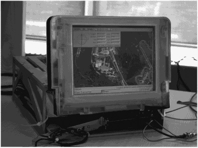
Figure 5-3 Navigation module for the automotive industry
screen controller. Secondly, systems with the PC and on-board screen controller require an additional separate screen. Finally, basic systems call for the acquisition of the three basic elements—PC, screen, and controller—separately. The advantages and disadvantages of these three systems are summarised in Table 5-1.
SECO's M570 [Seco] (see Figure 5-4), a basic system, is the one that best suits the requirements of the system and offers the best quality for its price. Its versatility, its high number of connectors, and the fact that the manufacturer is able to supply all the components were contributing factors to the selection of this system. Moreover, it is expandable by means of the PC/104-Plus connector.
Additionally, a touchscreen has been added in order to improve the user interface. The user can completely manage the navigator via the screen, selecting maps, searching routes, and so on. A picture of the system in the lab can be seen in Figure 5-5.
5.2.3.2 Industrial PC
There can be a number of choices found among the different processors. The processor selected for the module, is the: PC/104 CPU VIA Eden ESP 6000, which offers 600MHz with a PC/104-Plus connector. M570 [Seco] technical characteristics are shown as follows.
 CPU VIA EDEN (ESP4000—400MHz, ESP6000—600MHz, ESP8000—800MHz, ESP10000—1GHz)
 Two 64K L1 cache, one 64K L2 cache
 Bus speed up to 133MHz
 One SODIMM slot
 VIA VT8606 "Twister-T" Northbridge
 VIA VT82C686B Southbridge
 512KB flash memory BIOS directly soldered on board
 PCI Bus Rev. 2.2, accessible through PC/104-Plus connector
TABLE 5-1 Advantages and disadvantages of industrial PCs
|
Advantages |
Disadvantages |
Completely integrated |
Easiest and simplest option |
High price Fixed configuration |
On-board controller |
Moderate freedom with screen |
More complex PC-screen compatibility |
Basic system |
Cheapest solution High freedom Expandable |
Bulkier than other systems |
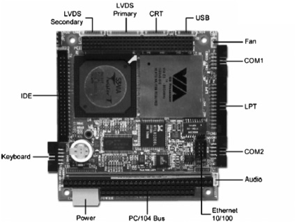
Figure 5-4 M570 of SECO [Seco]
 ISA bus accessible through PC/104 connector
 2.5-in. HDD UltraDMA-66 or DOM connector
 Ethernet 10/100BaseT interface
 AT keyboard connector
 PS/2 mouse connector
 LPT port configurable in SPP, bidirectional, ECP and EPP mode
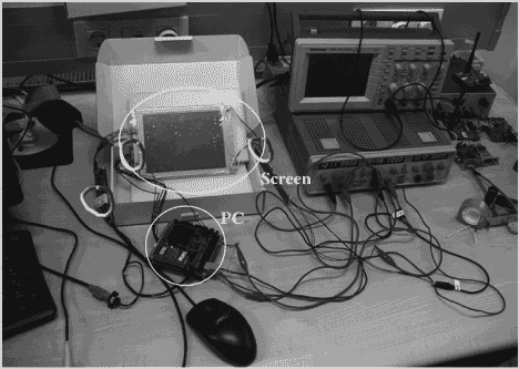
Figure 5-5 Entire system at the laboratory
 LPT connector programmable for the connection of an external FDD
 Two serial ports: one full modem RS-232, one programmable as RS-232/RS-422/RS-485
 Dual-channel audio port, 1W per channel
 Two USB 1.1 ports
 Integrated graphic controller
 Resolution up to 1920*1440*64K or 1760*1440*16.8 million colours with CRT monitor
 Dual-channel LVDS interface
 Support for TFT displays with resolution of 640x480, 800x600, 1024x768 or 1280x1024.
 Temperature, fan speed, and voltage monitor
 Power supply required: +5VDC, +12VDC
 PC/104 form factor: 3.5in.×3.8in. (90mm×96mm)
And the parts that the PC module is composed of are:
 CPU (PC/104 CPU VIA Eden)
 ESP 6000—600MHz, no PC/104-Plus connector
 ESP 6000—600MHz, with PC/104-Plus connector
 ESP 10000—1GHz, no PC/104-Plus connector
 ESP 10000—1GHz, with PC/104-Plus connector
 Memory
 128MB SO-DIMM module
 128MB IDE flash disk (with WinCE. NET 4.2)
 Display
 TFT LCD Display 6.5-in. 640/480 300cd/mq 2 CFL
 Connection cable M570/ML528/Inverter
 Inverter TDK
 LVDS receiver module for TFT display 6.4in.
 Touchscreen
 Resistive touchscreen four wire 6.5in.
 Interface touchscreen controller for four wire resistive
 Cable kit
 Connection cable kit
5.2.3.3 Software
Navigation software needs to be developed to deal with the information received from the receiver, process that information, and manage both maps and the user interface. The application works with the previously described hardware and processes the data from the GPS receiver and aerial photo maps to provide the user with a visual representation of the location.
5.2.3.3.1 Development Environment
Thanks to the Windows CE operating system, many well-known development tools are available. In this case, Microsoft's Embedded Visual C++ 4.0 Tools has been selected. This tool, which differs significantly from any other Windows-based software, is available at Microsoft's webpage. However, the system's numerous limitations must be taken into account. The developing process is briefly described as follows:
1. One of the advantages of having Windows CE on the industrial PC is that programming and checking can be done on a regular PC using an emulator provided by Embedded Visual C++ 4.0 Tools.
2. After the application is developed, the industrial PC can be connected to the PC via serial, USB, or Ethernet. This allows for the debugging of the application on the industrial PC.
Having Windows CE on the navigator is not only useful for the development of the software, but also to improve the module features, which use additional applications. Thus, a multifunctional module has been developed where the user could have, apart from the navigator, multimedia applications such as MP3, video, and DVD players and such in the same module. Moreover, Internet access can be made available by simply adding a 3G module to the system.
5.2.3.3.2 Map Management
Due to the large size of maps and the limitation of the system to store and process every map, a map management system has been developed. Maps will be downloaded from a secondary storage system (CD-ROM, pen-drive) as required. When the program starts, it creates a table in the memory, linking every map in order to download the required map every time. This system is totally user-friendly. A screen display of the application is shown in Figure 5-6.
5.2.3.4 User Interface
The program is user-friendly and intuitive. Although it is a standard Windows environment with menus and tool-bars, it also allows tactile use thanks to the touchscreen. Available options are shown in the following section.
5.2.3.4.1 View Tools
The view tools work in the same fashion as conventional image processing software. Basic options are listed as follows:
Applications 169
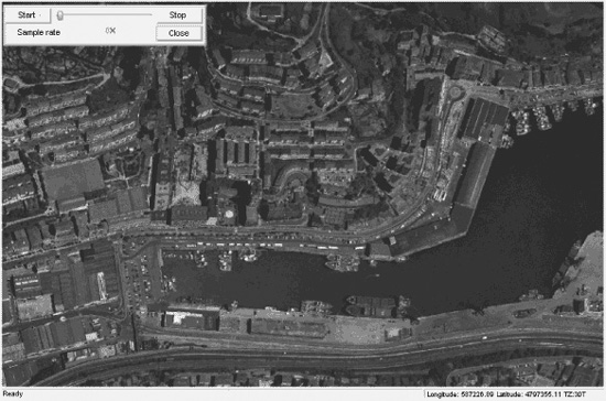
Figure 5-6 User interface
 Zoom in: This button allows the user to amplify and centre the map at the exact point where the user clicks the mouse. Zoom ratio is defined as 10 percent for every click.
 Zoom out: The same as the previous one, but the image zooms out rather than in. The zoom ratio is also 10 percent.
 Move: This tool allows the map to be moved in eight different directions. Depending on the location of the cursor, its shape will change to one of the directional arrows.
The Coordinates option is also a very useful tool, because it shows the coordinates of the selected point in two different standards (see Figure 5-7).
Moreover, the Monitor button of the toolbar shows the user the location, speed, direction, altitude, time, and number of satellites in view, as well as a magnet displaying the direction of the receiver. The use interface is shown in Figure 5-6.
5.2.3.4.2 Serial Connection
The Serial Connection option for the GPS can be found in the Serial Connection toolbar. When the program is started, the GPS receiver will be detected and the connection will start automatically. When it receives the first piece of location-related information,
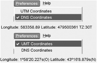
Figure 5-7 Selection of the type of coordinates
the software opens the relevant map containing the user's location. Connection parameters can be set by the users and any changes will be saved in the system register (see Figure 5-8).
A GPS configuration tool is available to correct GPS receiver offset. The actual location and direction can be easily corrected by means of the window shown in Figure 5-9 or by a dynamic capture. By selecting the option dynamic capture and clicking with the cursor on the map, the user sets the actual position. The program then calculates the offset between the location defined by the receiver and the real location set by the user. Calculated data are saved in the program register. Values are positive or negative depending on the direction of the change (south and west are negative).
The settings of this screen are as follows:
 Position Offset The offset of the real location is introduced in metres. The software will apply this setting offset to the data received by the receiver.
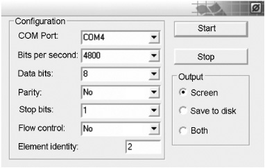
Figure 5-8 GPS serial connection window
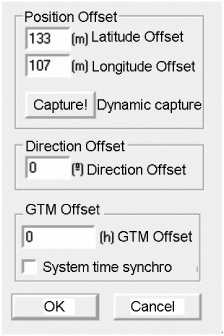
Figure 5-9 GPS configuration window
 Direction Offset The direction offset is set in degrees. The 0° reference is north or south increased counterclockwise.
 GMT Offset GPS receiver data also provide highly accurate universal time. To set the time, the program must introduce regional time differences.
 System time synchro The PC's clock provides the time when the navigation data served by the receiver fail to do so. It is advisable to synchronise the time to avoid the possibility of erroneous data from the software simulation. Moreover, it is a good way to have the PC's clock synchronised to a reliable source such as the GPS.
5.3 Summary
In this chapter a number of different fields which will be of benefit to a dual GPS/Galileo receiver have been listed and described. Moreover, the development of an entire receiver car module: selection of the digital processing receiver, onboard PC, touchscreen and software development has been described.
 Road The road sector is a major potential market for satellite navigation-based applications, since they are already commonly installed in new cars as a key tool for providing new services to people on the move. These include electronic charging, real-time traffic information, emergency calls, route guidance, fleet management, and Advanced Driving Assistance Systems (ADAS). Apart from these features, drivers, car manufacturers, and law enforcement officials can benefit from the increased availability of satellite navigation services in advanced car navigation systems. They can also reap the rewards of reduced travel time, demand management, and traffic monitoring and increased confidence in fleet management and tracking of goods in all industry sectors.


