Chapter 9
The Third Intermediate Period and Late Period
9.1 The Third Intermediate Period: Overview
The Third Intermediate Period represents a departure from traditional pharaonic rule of the Early Dynastic Period, and the Old, Middle, and New Kingdoms – and control of the entire country by a ruling dynasty of Egyptian kings. Although the rulers in Thebes recognized the 21st-Dynasty kings at Tanis in the northeastern Delta, there was divided rule between the north and south. A border was established at el-Hiba in Middle Egypt, where fortresses were built by the Theban rulers whose policies were sanctioned by oracles of the Theban gods. Egypt no longer controlled an empire in southwest Asia or in Nubia. The new political order is visible in the Tale of Wenamen, a fictional work in which an agent of the Temple of Amen at Karnak is dispatched to Byblos to obtain cedar for the god’s bark.
The petty states along the eastern Mediterranean were now independent of Egyptian control and Wenamen’s troubles exemplify Egypt’s greatly reduced power there. The tale also reflects the divided state of Egypt, between the theocratic power of Herihor in Thebes and King Smendes in Tanis. The diminished state of the royal ancestors can also be seen in the evidence at Thebes: from the end of the 20th Dynasty onward riches in the Theban tombs of the New Kingdom pharaohs were removed and the stripped-down royal mummies were reburied in caches – all of which was possibly sanctioned by the rulers of Thebes. Many of the New Kingdom private tombs at Thebes which had been plundered in the late 20th Dynasty were reused for family burials – with a reduced number of grave goods compared to the New Kingdom ones. With the end of royal burials in the Valley of the Kings the Deir el-Medina workmen’s community was closed, and in Tanis kings were buried within a massive temple complex that was protected within the walled city.
The 22nd, 23rd, and 24th Dynasties, located in different cities in the Delta, overlap in time, and writing a history of this period is problematic given a scarcity of king lists. Names and regnal years of these kings have been pieced together from inscriptions, but many sites in the Delta from which such information has been obtained have not been well preserved. The origins of Smendes, the first king of the 21st Dynasty, are unknown, and the other Delta rulers of this period were of Libyan descent. Kings of the 25th Dynasty were Kushites from Napata in Upper Nubia, reversing a 2,000-year tradition of Egyptian control of Nubia – with Nubian control of Egypt.
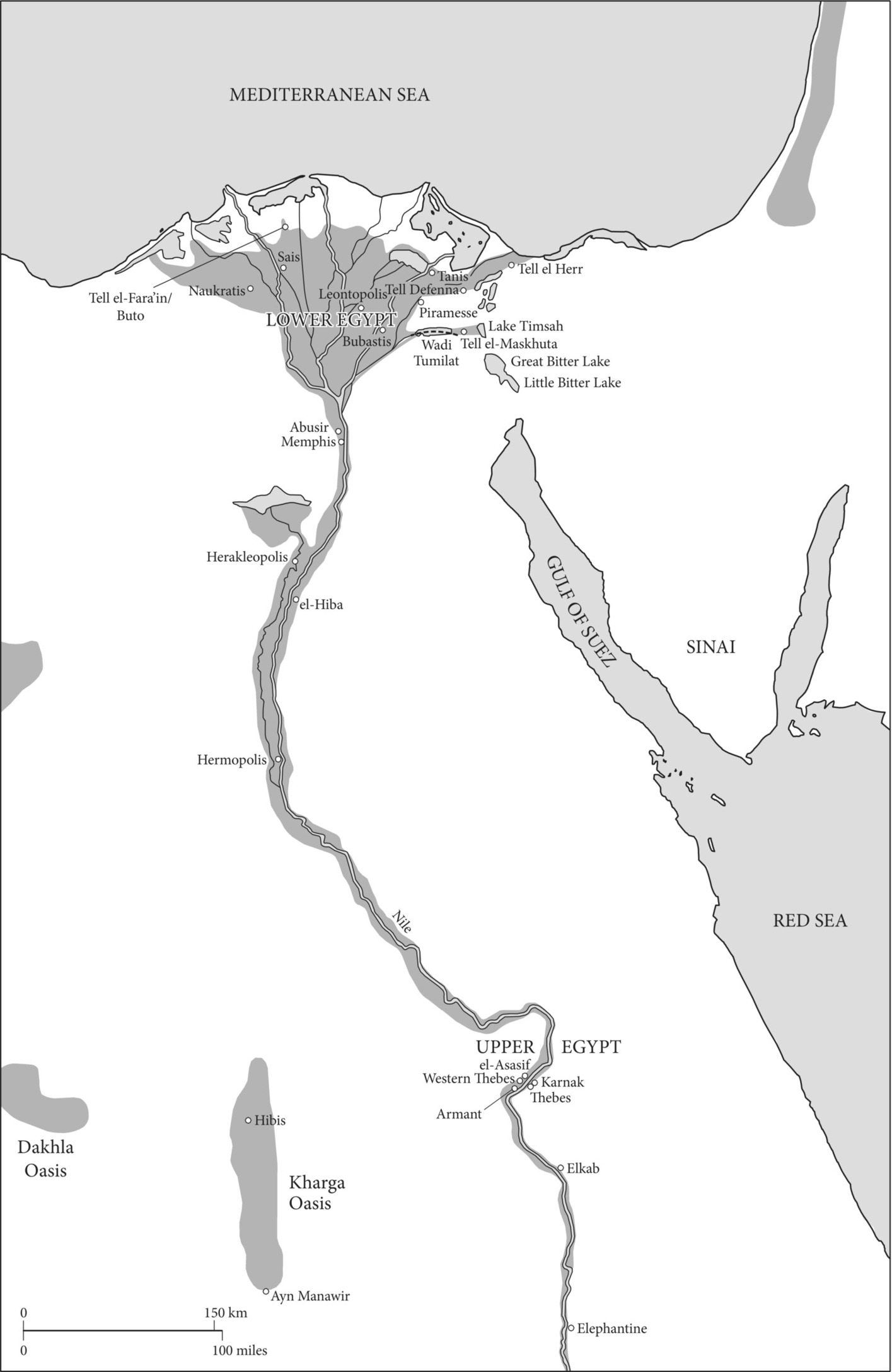
Map 9.1 Sites in Egypt, Sinai, and the Western Desert during the Third Intermediate Period and Late Period.
The geographic importance of the Delta was already evident in the 19th Dynasty when Rameses II built a new capital there (Piramesse). From the Third Intermediate Period onward, with the exception of the Kushite Dynasty, power and control in Egypt increasingly focused on the Delta. The 21st-Dynasty kings built a new royal city at Tanis, and to facilitate this some earlier monuments were removed from Piramesse and elsewhere in the north and re-erected at Tanis. Although Rameses III had successfully fought Libyan forces twice, there is textual evidence that conquered Libyans were assigned to military settlements in Egypt. By the end of the New Kingdom there were many Libyans living in northern Egypt, especially former mercenaries in the western Delta. Osorkon the Elder, son of the chief of the Meshwesh (a Libyan tribe), became king ca. 984 BC and the 21st Dynasty ended with the rule of a Theban high priest, Psusennes II. The Libyan Sheshonq I, whose family was in Bubastis, became the first king of the 22nd Dynasty – legitimized by his marriage to Psusennes II’s daughter and descent from his uncle, Osorkon the Elder. Sheshonq, who continued the kingship at Tanis, named his son high priest of Amen and commander of the army, and from this point onward kings in the north sought to curtail Theban power. Reasserting the role of the Egyptian king, Sheshonq erected a number of monuments, including the so-called Bubastite Portal at the Temple of Karnak where the king’s successful campaign against the states of Israel and Judah is recorded – which is also mentioned in the Old Testament (1 Kings 14:25–26). But Egyptian expansion into Palestine ended with Sheshonq’s death not long after this military campaign.
Increasing political fragmentation occurred throughout Upper and Lower Egypt during the 22nd Dynasty as many provincial offices became hereditary. By the reign of Sheshonq II the 23rd Dynasty was an independent polity in the Delta. Later other semi-autonomous petty kingdoms also emerged: at Bubastis and Leontopolis in the Delta, and at Herakleopolis and Hermopolis in Middle Egypt. There were also other independent groups, including four Great Chiefs of the Ma/Meshwesh and the “Prince of the West” at Sais. Not acknowledging any one king, Thebes remained the major power base in the south. One result of decentralization was more socio-political instability. Rameses III’s mortuary temple at Medinet Habu had already become a fortified settlement during the civil war at the end of the New Kingdom, and evidence of mud-brick fortresses of this period has been found in Middle and Upper Egypt.
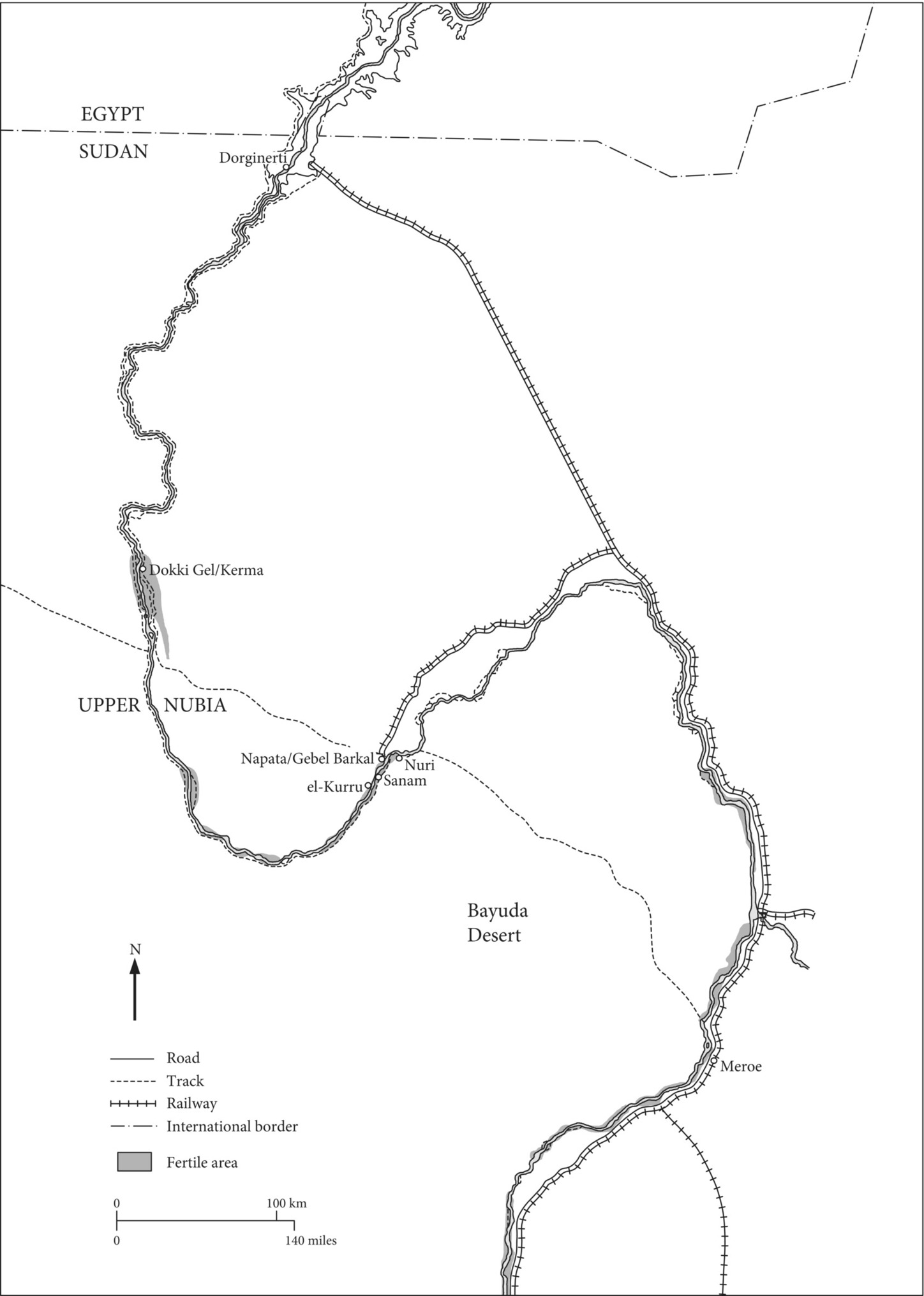
Little is known about Nubia after the New Kingdom because Egyptian control there ceased, as did written inscriptions. Sometime between the 11th and 9th centuries BC an indigenous polity arose in Upper Nubia, centered at Napata/Gebel Barkal, downstream from the Fourth Cataract, where Thutmose III had built an Amen temple. This polity became the second kingdom of Kush, with all of Nubia eventually under its control. The 25th Dynasty began with Kushite expansion northward; the kings of this dynasty controlled both Nubia and most of Egypt during a century of much warfare – between the Kushites and Libyan rulers in northern Egypt, and later between the forces of the Kushites and Egyptians and the invading Assyrians.
The Kushite conquest of Egypt began under Kashta in the mid-8th century BC, and his son Piy conquered Memphis. In Thebes Piy’s sister Amenirdis I became the God’s Wife of Amen, one of the most powerful offices there. But Piy returned to Nubia and his successor Shabaqo had to reconquer Egypt when local rulers in the Delta began to expand their territorial control.
For the most part the Kushite kings were nominal rulers of Egypt, who controlled Egypt because of their military might but left many local rulers in place. The Kushites also took an interest in southwest Asia and in 701 BC an army of Egyptians and Nubians was sent to Palestine to support Hezekiah of Judah against the Assyrian army under Sennacherib. Although Sennacherib claims to have defeated the Egyptian and Nubian army, their intervention may have helped the Hebrew kingdom to survive and the Assyrians withdrew from their siege of Jerusalem. During the reign of Taharqo (690–664 BC), Egypt was invaded three times by the Assyrians and the Kushite king retreated to Nubia, where he died. His successor Tanutamani invaded Egypt, but Assyrian retaliation was severe. Thebes was sacked at this time and Tanutamani withdrew to Nubia for good.
During the 25th Dynasty Memphis became the Kushite royal seat in Egypt and several kings built monuments there. Both in Egypt and Nubia Kushite kings built Egyptian-style temples, with their walls inscribed in Egyptian hieroglyphs. At Karnak Taharqo’s large kiosk is found in the temple’s first court, and next to the northwest corner of the sacred lake he built a chapel with inscribed subterranean chambers.
But the Kushite kings of the 25th Dynasty and their successors were buried in Upper Nubia. Before the Egyptian conquest Kushite kings were buried in a cemetery at el-Kurru, near Gebel Barkal, where the earliest high-status tombs were circular tumuli with contracted burials on beds – as in the centuries-earlier royal burials at Kerma. But Piy’s tomb at el-Kurru was a steep-sided pyramid. Most of the later Napatan kings, beginning with Taharqo, were buried in pyramids at Nuri, on the other side of the river. The kings’ bodies were mummified and placed in coffins, and royal mortuary compositions used by New Kingdom kings were painted in their burial chambers.
The Kushite pyramids, with chapels on the east side, are probably the most visible mortuary evidence of Egyptian acculturation by these kings, who worshipped Egyptian gods, especially Amen and Ptah, as well as non-Egyptian ones. But some Nubian beliefs were retained, such as the horse burials associated with Kushite royal burials. Kushite kings were often shown wearing a leather cap (not an Egyptian crown, see Figure 9.1), surmounted not by the heads of a vulture and cobra, which were symbols of Egyptian kingship (for example, on the gold funerary mask of Tutankhamen), but by two cobras (the double uraeus). Thus Egyptian royal symbols – and beliefs – were selectively adopted by the Kushite kings and transformed within their own distinctive culture.
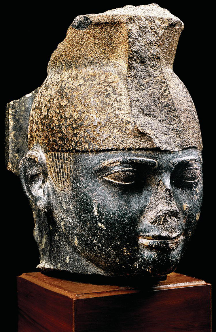
Figure 9.1 Taharqo head with a cap crown.
Source: Jürgen Liepe.
Although the Kushite monuments in Nubia are well preserved, the archaeological evidence in Egypt of this dynasty and earlier ones of the Third Intermediate Period is biased against many areas of settlement in the Delta and the Memphis region. This is also true for the Late Period, and the evidence discussed here does not represent the extent of urbanism that had developed in Egypt by the first millennium BC.
9.2 The Late Period: Overview
Nekau, an Egyptian ruler in Sais who had not supported the Kushite king Taharqo during the Assyrian invasions, was killed by Taharqo’s successor Tanutamani. But Nekau was succeeded by his son Psamtek, who became a vassal of the Assyrians. After breaking his alliance with the Assyrians, who were threatened nearer to their homeland by a coalition of Babylonians and Medes, Psamtek eventually reunited Egypt under his kingship – bringing an end to the Third Intermediate Period.
Thus the Late Period begins with an Egyptian dynasty whose origins were in the northwest Delta at Sais. The Saite Dynasty, as it is sometimes called, was a period of indigenous rule during which Egypt was no longer dominated by foreign powers. Saite kings ruled until 525 BC, when Egypt was conquered by another superpower from southwest Asia, the Achaemenid Persians. During the 27th Dynasty Egypt was a satrapy of the Persian Empire for over 100 years, with the Persian king assuming the role of pharaoh but ruling from Iran. The frequent Egyptian rebellions finally succeeded in throwing off Persian control in 404 BC, and three dynasties of ruling families in the Delta (the 28th, 29th, and 30th Dynasties) successively competed for control. The Late Period ends with a brief second period of Persian domination, the 31st Dynasty, but the collapse of the entire Persian Empire was soon brought about by the conquests of Alexander of Macedon.
Psamtek I of the 26th Dynasty had a very long reign – 54 years. By ca. 656 BC he controlled the whole country and his daughter Nitiqret became the God’s Wife of Amen. Foreign mercenaries, especially Ionian Greeks and Carians, provided strength in Psamtek’s army. Not only were there external threats, but also internal ones – of a warrior class called machimoi of ultimately Libyan descent. At Tell Defenna in the Delta on the Pelusiac branch of the Nile, Flinders Petrie excavated a huge enclosure within which was a high mud-brick platform, built under Psamtek I. Petrie thought that the platform was the base for a huge fort, and Greek military equipment from the settlement area to the east provided evidence of these mercenaries being enlisted in the Egyptian army.
With the resurgence of Egyptian rule and a unified state came economic prosperity. Use of the demotic script also developed during this dynasty (see 2.3). Underpinning the economy was the richness of Egypt’s agricultural base. Trade connections that Psamtek forged in the eastern Mediterranean increased his economic base, as did the extensive trade with Greek cities, which later in the Saite Dynasty was required by law to be conducted through the Greek city of Naukratis near Sais. Flinders Petrie investigated Naukratis in 1884–1885, but even at that early date a large section of the ancient city had been disturbed by farmers digging for organic deposits (sebbakh) for fertilizer.
Psamtek’s son Nekau II, who initiated trade with the southern Red Sea region, began construction of a canal from the Delta’s Pelusiac branch through the Wadi Tumilat to the Gulf of Suez. According to Herodotus, Egyptian ships at this time circumnavigated Africa – which probably reflects expanding trade in the Red Sea but not historical reality. The Phoenicians were also involved in the Red Sea trade, which included southern Arabia, at this time. But exotic raw materials from Nubia and the Punt region were also coming down the Nile. From the Dorginarti fort on an island in the Second Cataract, Lisa Heidorn has identified Egyptian, East Greek, and Levantine pottery which dates to the late Kushite, Saite, and Persian periods – indicating that there was movement of goods and people up the Nile through Lower Nubia as well.
The Saite kings built at Memphis/Saqqara, and at other sites in the Delta, Upper Egypt, and the oases of the Western Desert. Their major monuments, however, would have been at Sais, especially at a temple of the goddess Neith where these kings were buried in a temple courtyard. Little remains of this site to the north of the modern village of Sa el-Hagar, which may partially cover the ancient settlement. A huge enclosure with still standing buildings was described by visitors there in the early 19th century (including Jean-François Champollion). But British archaeologists at the site in the late 20th century describe a huge pit excavated for sebbakh, now filled with marshland, and seeping pools of water – and fragments of basalt, granite, limestone, and quartzite from ancient monuments. Despite such destruction, they were able to excavate surviving evidence of a Third Intermediate Period settlement of small-roomed houses in the northern part of the site.
A kind of archaism is seen in the art of both the Kushite and Saite dynasties, with tomb reliefs, sculptures, and mortuary texts reviving earlier models, especially from the Old and Middle Kingdoms. But artists did not simply copy earlier styles – they created innovative statues and reliefs. Large high-status tombs were built, especially at Saqqara, where animal cults had become popular. From Saite times onward Apis bulls were buried at Saqqara in huge granite or basalt sarcophagi, in the underground Greater Vaults of the Serapeum.
Although the Saite military expanded briefly into southwest Asia – to the east of the Euphrates River – Nekau II’s army was defeated at Carchemish in northwest Syria. But Nekau was able to keep the new superpower, the Neo-Babylonian Empire, from invading Egypt. Nekau II’s successor Psamtek II sent an expedition to Upper Nubia, subduing any Kushite threat for the remaining years of the Saite Dynasty, and in Egypt Psamtek II had Kushite monuments defaced. But the Babylonians remained a threat to the succeeding king, Apries, who also sent an Egyptian army to northeastern Libya to settle a dispute with the powerful Greek colony of Cyrene.
Apries’s name appears on column fragments from a large palace at Memphis, investigated by Flinders Petrie and later by Barry Kemp. Built on top of an enormous mud-brick platform (over 13 meters high by Kemp’s estimate), the palace had two huge columned halls. Unlike earlier palaces, its floors and lower walls were covered with limestone, and there were elaborate stone-covered gateways. Although Apries’s palace continued to be used in the Late Period, the king’s political fortunes were definitely on the wane. His army was defeated in Cyrene. Together with resentment at Apries’s favoring his Greek and Carian mercenaries, this setback caused a mutiny. Fleeing Egypt, Apries gained the backing of the Babylonian king Nebuchadrezzar II, who intended to set Apries up as a puppet-king. But the Egyptian army, led by Ahmose II/Amasis, who had usurped the throne, defeated the Babylonian forces and Apries was killed. The short reign of Ahmose II’s son Psamtek III ended with the Persian invasion of Egypt in 525 BC led by Cambyses, who had Psamtek executed.
Most of the Persian kings of the 27th Dynasty ruled from a distance, and Saite/Egyptian organization of the government was mostly maintained. The Egyptian legal system was codified. At the top, the country was controlled by a Persian satrap, and Aramaic, the lingua franca of southwest Asia, was used in the Persian satrap’s office as a language of administration.
Persian control of Egypt was aided by their strong military presence – including the use of Jewish mercenaries already in residence at Elephantine. Evidence of a Persian fort is found in the northwestern Sinai at Tell el-Herr, and during the Persian Period the fortified Saite settlement at Tell el-Maskhuta, in the middle of the Wadi Tumilat (eastern Delta), expanded in occupation. Such efforts by the Persians, however, did not prevent frequent Egyptian revolts.
The Persians supported Egyptian religion by building temples, which may in part have been an attempt to legitimize the Persian king as pharaoh. Most of the Persian monuments date to the earlier part of the dynasty, after which conditions seem to have been very unsettled. One of the better-preserved temples of this period is at Hibis in Kharga Oasis. Begun under the Saites, the Hibis temple was enlarged and decorated by the Persian king Darius I.
At Ayn Manawir in the southern Kharga Oasis French archaeologists have discovered a sophisticated water supply system, used from the 27th Dynasty through Roman times. Twenty-two qanats, long and deep subterranean galleries, were excavated in the sandstone bedrock. Water trapped in the bedrock during more moist climatic periods (early Holocene) would have drained into the qanats, supplying irrigation water for nearby land impossible to farm otherwise. Several small villages and a temple have also been excavated at Ayn Manawir, and 450 demotic ostraca were found in a temple annex room. The ostraca date from the late 26th to early 30th Dynasties and are mainly economic records, such as accounts, receipts, and contracts. The contracts point to the introduction of a monetary system, with the use of the Athenian silver tetradrachma coin as the standard, beginning in the reign of Darius II. Egypt was not widely monetized, however, until Ptolemaic times.
During the reign of Darius I the Delta canal, which was begun by Nekau II, was completed through the Wadi Tumilat to Lake Timsah and south to the Bitter Lakes and the Gulf of Suez (a different route from the modern Suez Canal, which in the north begins at Port Said on the Mediterranean), and Egyptian naval forces were used by the Persians in their attempts to conquer Greece. Later in the Persian Dynasty, after ca. 450 BC, the Greek historian Herodotus visited Egypt and wrote his histories, which were generally biased against the Persians. With the death of the Persian king Darius II in 404 BC the Egyptians forced the Persians out of Egypt for over 60 years.
Although there was much political instability for the last Egyptian rulers of the 28th (one ruler for only five years), 29th, and 30th Dynasties, including the looming threat of the Persians and a civil war in 360 BC, monuments were constructed throughout Egypt, including the imposing easternmost gateway at the Temple of Karnak. At Elkab an enormous mud-brick enclosure (ca. 530 × 600 meters) was built in the 30th Dynasty, possibly as a fortification in the event of another Persian invasion. Although a small temple there was built by either Nectanebo I or II, most of the surviving monuments and town date to the Greco-Roman Period.
When the Persians reconquered Egypt in 341 BC, many temples were plundered. But Persian efforts to re-establish internal control were met with rebellion. For the Egyptians, Alexander the Great’s invasion in 332 BC was a welcome end to the hated Persians’ regime.
9.3 Tanis: A New City with Royal Tombs
Located in the northeastern Delta, Tanis (known today as San el-Hagar) was the royal city and port of the 21st and 22nd Dynasties. The city was built on two geziras (mounded natural formations of sand); the northern one, which is called Tell San el-Hagar, has remains covering an area of ca. 177 hectares. Although many of the monumental stone blocks found at Tanis are inscribed with the cartouches of Rameses II and his son Merenptah, it is now evident that they were moved there from the 19th-Dynasty capital of Piramesse (modern Qantir), and other sites, perhaps by way of Piramesse. According to Manfred Bietak, Piramesse was probably abandoned because it was located next to the Pelusiac branch of the Nile, by then silted up.
Tanis was investigated in 1860 by Auguste Mariette, and two decades later Flinders Petrie excavated there. In the 20th century the site was excavated by French archaeologists and work continues there under the direction of Philippe Brissaud. Because the site covers an enormous area, Brissaud has studied the many mounded features with photographs taken by a camera suspended from a kite, which has been helpful in differentiating Greco-Roman Period structures built over ones of the Third Intermediate Period. Outside of the great temple precinct much of the ancient city remains to be investigated (Figure 9.2).
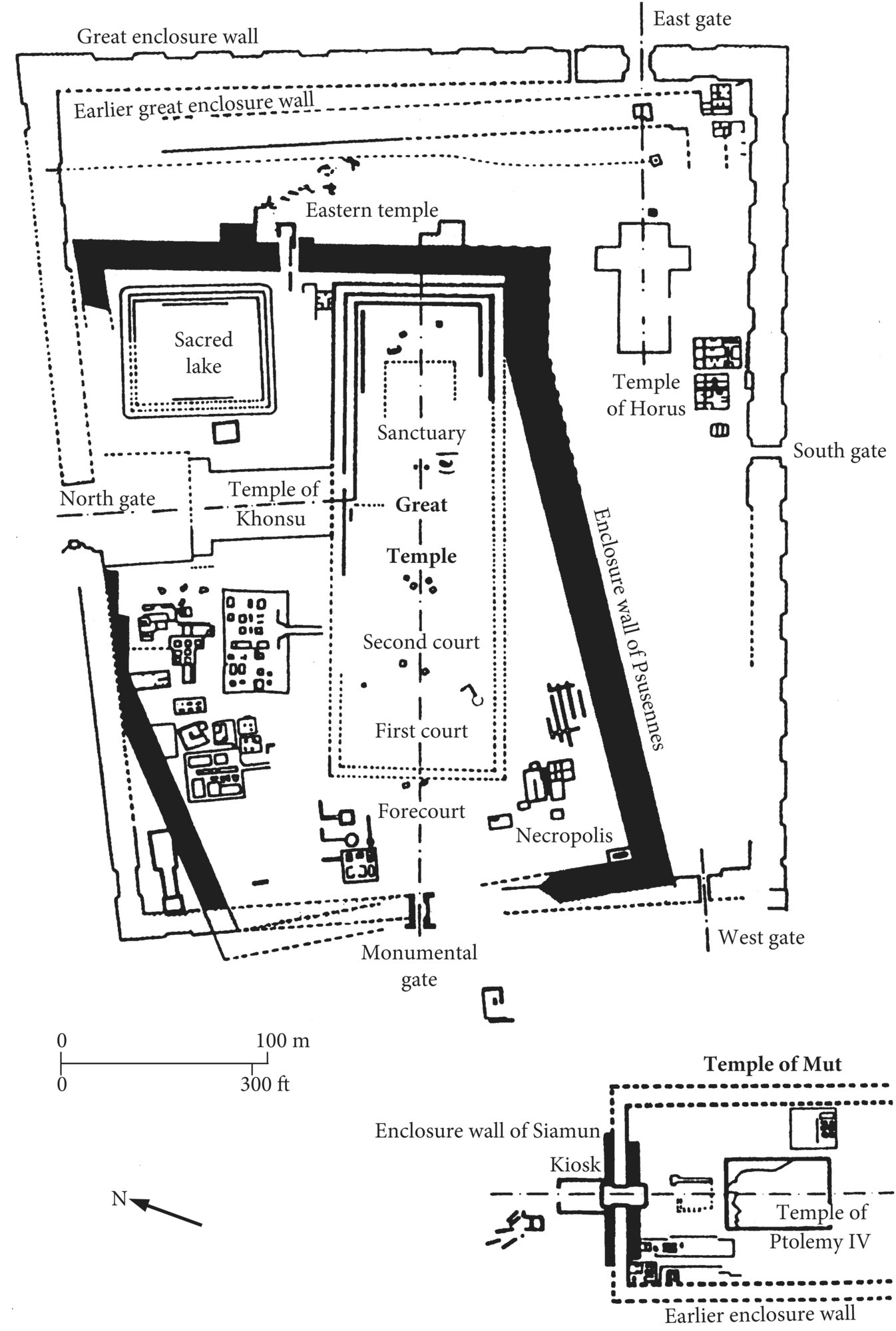
Figure 9.2 Plan of the temples and royal tombs at Tanis.
Source: Ian Shaw (ed.), The Oxford History of Ancient Egypt. Oxford: Oxford University Press, 2000, p. 332.
The most imposing monument at Tanis was the Temple of Amen, founded in the 21st Dynasty by Psusennes I, who also built the temple’s polygonal enclosure wall. Blocks for the Amen temple were transferred not only from Piramesse, but also from other monuments of the Old, Middle, and New Kingdoms. The entire complex, including a later Temple of Horus to the east (begun in the 30th Dynasty and finished by a Ptolemaic king) was surrounded by a second, massive mud-brick enclosure wall (430 × 370 meters, and 15 meters thick). On the western side of this wall Sheshonq III built a large monumental gateway, which was connected to the temple’s pylon by a processional way lined with obelisks of Rameses II.
In 1939 French archaeologist Pierre Montet discovered a subterranean mortuary monument at Tanis, within Psusennes I’s enclosure wall and to the southwest of the Amen temple’s first pylon. Hidden beneath the remains of houses of the later first millennium BC, the tombs contained a great number of rich grave goods, including the solid silver coffin of Psusennes I. Constructed of much reused limestone and granite, the funerary complex consists of nine tombs, including the burials of two 21st-Dynasty kings, Psusennes I and Amenemnisu (originally built for Psusennes’s queen Mutnedjemet), Psusennes I’s son Ankhefenmut, and a high official of this king named Wendjebawendjedet (Figure 9.3). Burials of the 22nd Dynasty include those of Sheshonq II, Osorkon II, Osorkon’s young son Hornakht, and Takelot II. Several tomb chambers in the complex could not be identified with named owners, and Tomb 5, originally for Sheshonq III, possibly contained the burial of Sheshonq I, whose canopic jar and heart scarab were found in it.
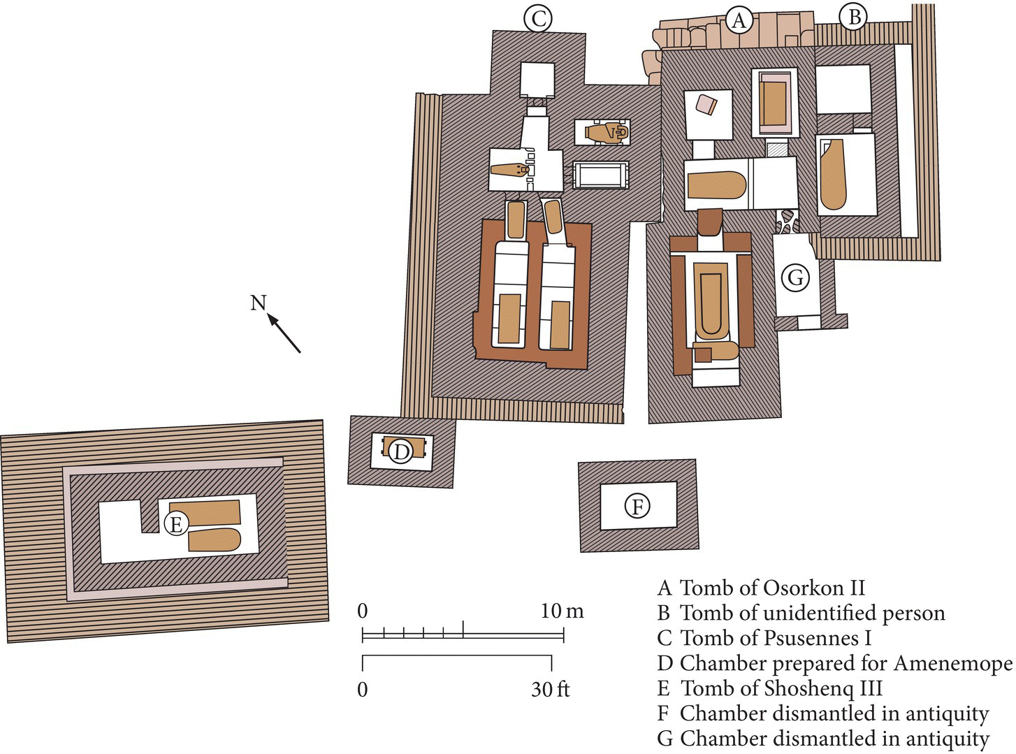
Figure 9.3 Plan of the royal necropolis at Tanis.
Source: Ian Shaw, Exploring Ancient Egypt. Oxford: Oxford University Press, 2003, p. 228.
Although some of the burials in the Tanis funerary complex had been robbed in antiquity, the tomb of Psusennes I (Tomb 3) was undisturbed. This tomb was designed with an antechamber and two other rooms in limestone, and two granite burial chambers, the northern one of which contained Psusennes’s burial. The king’s burial consisted of a granite sarcophagus usurped from the Valley of the Kings, which had originally belonged to Merenptah, and an inner granodiorite coffin, within which was the silver coffin.
Psusennes’s mummy was covered with a gold funerary mask inlaid with glass and lapis lazuli – reminiscent of Tutankhamen’s gold mask. Jewelry found on the mummy and within the tomb included a gold necklace with the king’s cartouches, which weighs over 8.5 kilograms (Plate 9.1), and many inlaid gold pieces: two pectoral necklaces, four scarab pendants, and many rings.
To what extent Tanis functioned as a ruling capital of these dynasties is uncertain; this will hopefully be clarified with further excavations there. The city was a major cult center for the state god Amen and the Theban triad, and it was also a royal place of burial where pharaonic traditions continued in modified and still grand forms.
9.4 Napata/Gebel Barkal and Sanam
Although the Kushite kings of the 25th Dynasty ruled over both Egypt and Nubia, their political center was at Napata, downstream from the Fourth Cataract. The most prominent physical feature of the ancient city of Napata is the sandstone outcrop known as Gebel Barkal, its steep cliffs rising over 100 meters above the plain. When Egypt controlled Upper Nubia in the New Kingdom the mountain was believed to be sacred – the chief Nubian residence of their god Amen. This was where Thutmose III erected a temple that was later enlarged in the 19th Dynasty. Although the origins of the later Kushite state are unknown, by the 9th/8th centuries bc, Napata was the center of this indigenous polity, whose state religion focused on the Amen cult there. Of great symbolic importance to the Kushite kingship, the Napatan cults of Amen of Karnak and Amen of Napata were believed to confer legitimacy upon the king. Extending to the east from the base of Gebel Barkal a number of temples and a palace complex were built by the 25th-Dynasty kings and their successors (Figure 9.4).
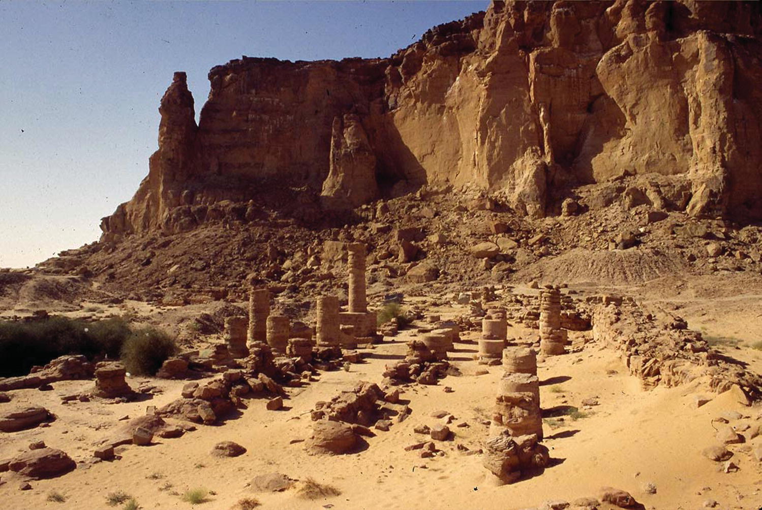
Figure 9.4 View of temples at the base of Gebel Barkal.
Source: © Timothy Kendall.
The first major excavations at Napata were by George Reisner (1916–1920) and understanding of the sequence of temple construction is based on his work. In the early 8th century BC a mud-brick temple with stone columns (B 800-sub in Reisner’s numbering system) was built there, probably by a Kushite king named Alara. His successor Kashta, who began the conquest of Egypt, extended this temple in stone and built an adjacent palace. Kashta’s son Piy restored the 18th/19th-Dynasty temple (B 500) at Napata, which was over 150 meters long, and rebuilt temple B 800 in stone. Piy also restored the large hypostyle hall that had been added onto the 18th-Dynasty temple by Sety I and Rameses II. King Taharqo, who also left a number of temple monuments in Egypt, built two temples at Napata (B 200 and B 300). The last king of the 25th Dynasty, Tanutamani, built a kiosk structure inside temple B 500.
The Napatan temples were designed in the style of Egyptian ones, with a series of pylons, an outer court, hypostyle hall, pronaos, and inner sanctuary (naos) and chapels. The continued importance of the state cult of Amen, which was introduced into Upper Nubia in the New Kingdom, probably helped to reinforce the role of Kushite kings there. The Kushites spoke an indigenous language (Meroitic), for which they did not yet have a writing system, and inscriptions on the Napatan temples (and in tombs) are in Egyptian hieroglyphs.
After the 25th Dynasty Kushite kings continued to build at Napata, and restoration took place after the site was pillaged and burned – most likely by an invasion of the army of the Saite king Psamtek II. At the site of Dokki Gel, to the north of Kerma, archaeologists of the University of Geneva mission have found fragments of seven monumental statues of Kushite kings that were ritually buried after Psamtek’s invasion.
Later, when Meroe became the seat of the Kushite rulers, temple restoration and construction continued at Napata, and new palaces were also erected there – due, no doubt, to Napata’s cultic importance. While the earlier temples were built in an arc at the base of Gebel Barkal, the latest ones and a large palace complex were erected in an area to the northeast of the gebel.
Much archaeological work remains to be done at Napata. Timothy Kendall resumed Reisner’s work there late in the 20th century, and Italian and Spanish archaeologists have also been excavating there. An exciting find occurred in 1987, when, with the help of an American rock climber, Kendall scaled a pinnacle separated from the main gebel, where he copied an inscription of Taharqo, first seen with binoculars. The inscription was originally covered with gold sheeting.
Archaeological investigations at Napata have focused on the monuments there – the temples and palaces, and tombs to the west of the gebel. Thus the evidence suggests that Napata was a cult center with royal residences (that may also have had administrative functions). But the plan of the city remains unknown – as are any domestic quarters for its non-elite and industrial areas where its artisans and craftsmen would have worked.
Across the river from Napata is the site of Sanam, at the end of the track/road that crossed the Bayuda Desert from Meroe farther upstream – a much shorter route than the trip by boat downstream. Sanam was excavated by an Oxford University expedition in 1912–1913, led by Francis Llewellyn Griffith. A large Amen temple was located at this site, where there was also evidence of craft workshops for shawabtis and other small artifacts. In the desert to the east of the temple Griffith excavated what he called the “treasury,” a columned building over 250 meters long with 17 storerooms to either side of a central corridor. Artifacts with cartouches of Kushite kings (Piy to Aspelta) date the structure from the 25th Dynasty to the mid-6th century BC. In both the Sanam temple and “treasury” there is evidence of large-scale burning. Piles of ivory tusks were found in one room of the “treasury,” and this structure may have been a kind of warehouse for the exotic raw materials imported through Nubia from regions to the east of the Nile – a major source of state wealth.
Over 1,500 burials of different types/statuses were also excavated at Sanam. Possibly the Egyptian-style burials there, in subterranean chambers entered by staircases, with mummified remains in coffins and Egyptian grave goods and wheel-made pottery, belonged to Egyptians (and Egyptianized Nubians?) employed as bureaucrats and artisans by the Kushite kings. Another type of burial at Sanam, of extended bodies in rectangular pits accompanied by wheel-made pots, may represent a lower-status Egyptianized group. The simplest burials, of contracted bodies with both wheel-made and hand-made pottery, and multiple burials with no grave goods, may be graves of the non-elite majority of the Napatan population who worked there and were buried at a different location from the Napatan royal cemeteries. While Napata may have been the center of the state religion and the royal seat where the accession took place, Sanam may have functioned as an important economic (and industrial?) center.
9.5 el-Kurru and Nuri: The Kushite Royal Tombs
Although two post-25th-Dynasty Napatan royal tombs (and some Meroitic royal tombs) are found in the cemetery to the west of Gebel Barkal, the earliest royal tombs were built in a cemetery at el-Kurru, 15 kilometers downstream from Napata (Figure 9.5). George Reisner found evidence of a walled town at el-Kurru (which he never published), and Timothy Kendall has suggested that this was the earliest seat of the Kushite Dynasty.
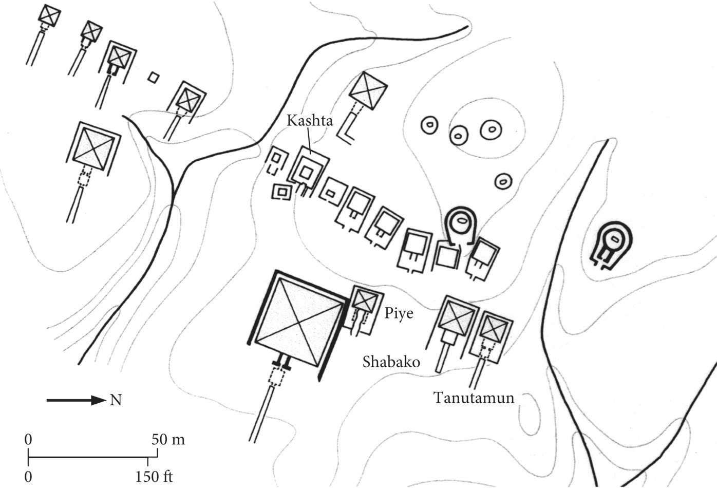
Figure 9.5 Plan of the royal cemetery at el-Kurru.
Source: Drawn by Tracy Wellman. From Mark Lehner, The Complete Pyramids. London and New York: Thames & Hudson, 1997, p. 195.
At el-Kurru Reisner excavated 16 tombs which he thought were ancestral to King Piy, including tomb Ku. 8, which he identified as belonging to Piy’s predecessor Kashta. The earliest tombs (Ku. Tum. 1, 2, 4, 5) were round tumuli of stone with subterranean burial pits – reminiscent of some C-Group burials of the Second Intermediate Period. Two later tumuli, Ku. Tum. 6 and Ku. 19, had horseshoe-shaped enclosure walls built with masonry blocks. Made of mud-brick, the earliest funerary chapel appears on the east side of Ku. Tum. 6.
The ten other ancestral tombs at el-Kurru (Ku. 7, 8, 9, 10, 11, 13, 14, 20, 21, 23) had square superstructures, only two of which did not have chapels (Ku. 20 and 21). These two tombs were smaller than the others and perhaps belonged to queens or other family members of the king buried in Ku. 8, the largest of these tombs. Although Reisner thought that these ten tombs were square flat mastabas, Kendall’s investigations indicate that they were probably small pyramids.
Map 9.2 Sites in Upper Nubia from the Third Intermediate Period onward.
Piy’s pyramid tomb at el-Kurru (Ku. 17) represents a further elaboration of tomb design. In a 5.5-meter-deep pit, the tomb chamber was partially rock-cut with a corbel vaulted roof. It was entered by a rock-cut stairway, which was covered by a funerary chapel after the burial had taken place. The pyramid was made of solid masonry with four smooth faces.
Three other kings of the 25th Dynasty, Shabaqo, Shabitqo, and Tanutamani, were also buried at el-Kurru in similarly constructed monuments. But with steep sides and bases only 8–11 meters in length, the el-Kurru pyramids were very different in shape and size from the much earlier Egyptian royal tombs of the Old and Middle Kingdoms. The el-Kurru pyramids are more similar to the small pyramids over private New Kingdom tombs at Thebes.
At el-Kurru the chief queens of Piy and later kings were buried in smaller pyramid tombs on a ridge to the southwest, and minor queens were buried in separate cemeteries. Reisner also excavated a cemetery with 24 horse burials, of the four 25th-Dynasty kings who were buried at el-Kurru. The horses were found standing in four groups of pits and facing the southeast.
There is a clear evolution of tomb types at el-Kurru from indigenous-type Nubian stone tumuli, to tumuli surrounded by horseshoe-shaped enclosure walls (one with a funerary chapel), to pyramid superstructures. The Egyptianization of these tombs is also seen in the burials: the earliest ones were contracted and placed on beds (in Nubian tradition), while later ones were extended (as Egyptians were buried) and oriented east–west. With the conquest of Egypt, the Kushite royal burials emulated Egyptian ones in the treatment of the body: the body was mummified and placed in nested coffins, and the viscera were embalmed separately in canopic jars. Large numbers of Egyptian-type shawabtis were also included as tomb goods. It is likely that Egyptian and Egyptian-trained craftsmen decorated the royal tombs and made many of the artifacts that Reisner found there.
Taharqo was the first king to build his pyramid tomb in a new cemetery, Nuri, 10 kilometers upstream from Napata and on the opposite bank of the Nile (see Figure 9.6). This cemetery was used for the pyramid tombs of 21 later Napatan kings (post-25th Dynasty) to the time of Nastasen (ca. 335–315 BC), and 53 queens, who were buried beneath considerably smaller pyramids.
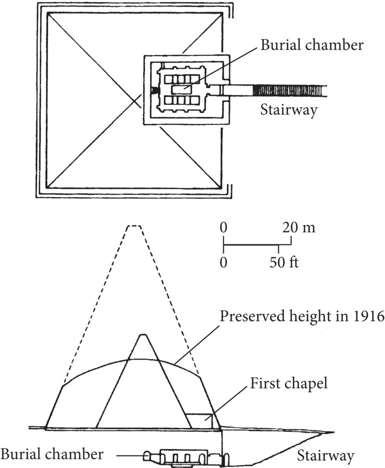
Figure 9.6 Plan and cross-section of the pyramid of Taharqo at Nuri.
Source: Drawn by Tracy Wellman. From Mark Lehner, The Complete Pyramids. London and New York: Thames & Hudson, 1997, p. 196.
With a base length of 51.75 meters, Taharqo’s pyramid is much larger than any at el-Kurru – as well as the later pyramids at Nuri. But an earlier pyramid with a base length of 28.5 meters and four smooth faces had first been built for Taharqo’s tomb. Taharqo’s later pyramid, which perhaps covered a funerary chapel to the east, was stepped in design, as were most later Kushite pyramids. Taharqo’s subterranean rock-cut tomb was also huge – 21 × 16.5 meters. A narrow rectangular passage was cut around the inner rectangular tomb, which had two rows of huge rock-cut piers (more than 1 meter thick) and a low platform for the burial in the center. The tomb’s ceiling consisted of rock-cut barrel vaults.
The other kings’ tombs at Nuri had funerary chapels with a pylon façade built on the southeast side of the pyramid. Up to three tomb chambers were cut 8–9 meters below ground and many were decorated with Egyptian mortuary scenes and texts. As in the later el-Kurru royal tombs, the kings’ bodies were mummified and placed in nested coffins, with the viscera in canopic jars. Evidence suggests that gold was used extensively on parts of the royal mummies, including gold masks and foil covering the fingers and toes – in a similar fashion to what Howard Carter found on Tutankhamen’s mummy. Hundreds of shawabtis were also found in these burials. Although these kings no longer controlled Egypt, they continued to be buried according to Egyptian customs for the royal dead.
In the early 4th century BC royal burials were discontinued at Nuri, as Meroe, located much farther upstream, became the place of Kushite royal burials.
9.6 Saqqara: The Serapeum and Animal Cults
The bull was an animal symbolically associated with the Egyptian king from early times, and different cults for bull gods are known in ancient Egypt. Although the cult of the Apis bull at Memphis may have existed as early as the Early Dynastic Period, the earliest individual bull burials discovered at Saqqara date to the later 18th Dynasty (reign of Amenhotep III). Subterranean galleries for burial of the Apis bulls, known as the Lesser Vaults, were begun at Saqqara late in the reign of Rameses II and were in use until the Greater Vaults were begun in the early 26th Dynasty under Psamtek I. During the Saite Dynasty the Apis bull cult and other animal cults had enormous resources invested in them, which continued through Ptolemaic times.
The Serapeum, where the Apis bulls were buried, is located to the northwest of Djoser’s Step Pyramid. In 1851 Auguste Mariette began excavating at Saqqara intent on finding the Serapeum Way, the east–west processional route across Saqqara leading to the Apis burial galleries – at the time known only from classical sources. Mariette excavated the galleries and uncovered a huge number of artifacts associated with the processional route (see Figures 9.7 and 9.8). Two ships were sent from France to transport the artifacts to Europe; most are now in the Louvre Museum.
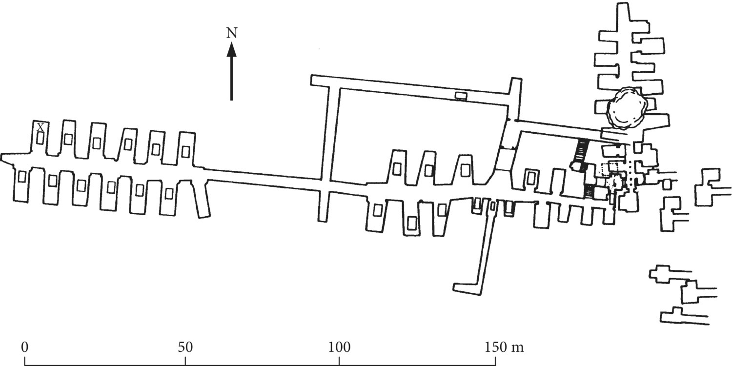
Figure 9.7 Plan of the Serapeum at Saqqara.
Source: Drawing by Michael Jones. K. A. Bard (ed.), The Encyclopedia of the Archaeology of Ancient Egypt. London: Routledge, 1999, p. 715.
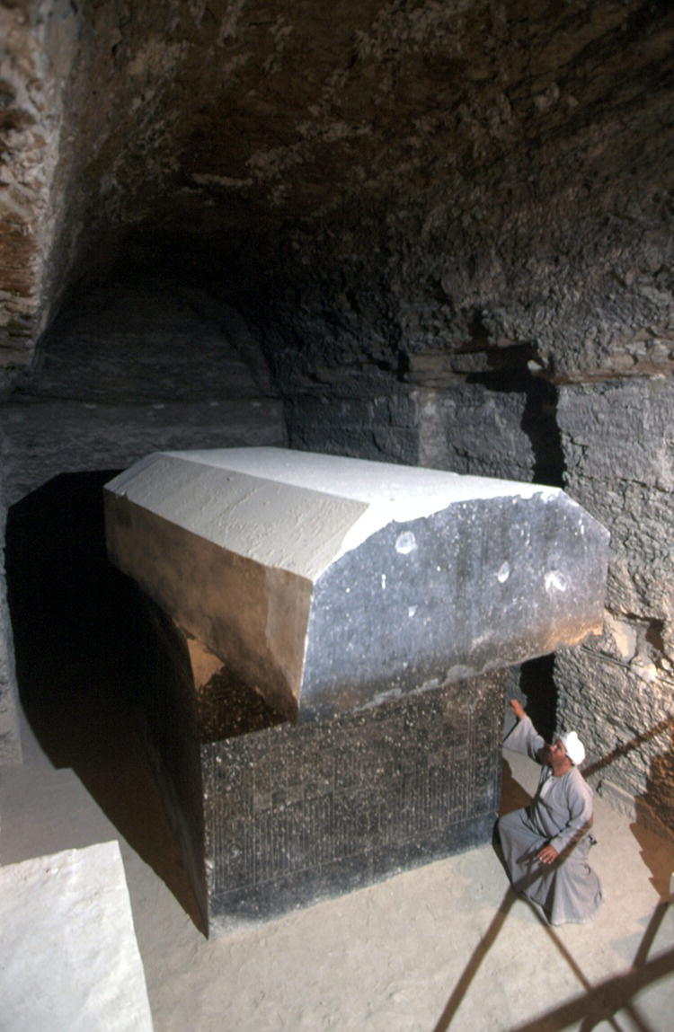
Figure 9.8 Granite sarcophagus of a sacred Apis bull, buried in the underground gallery of the Serapeum at Saqqara. Picture taken in 1997.
Source: Photo12/Jean Guichard.
The Serapeum Way was begun in the 26th Dynasty, and in the 30th Dynasty 134 sphinxes were placed along the route. During the Ptolemaic Dynasty Hellenistic statues of 11 Greek philosophers and writers were placed near the end of this route. Among Mariette’s finds were hundreds of royal stelae, which provide information about the Apis bull cult. Dates are often given for the bull’s birth, its installation in the Temple of Ptah in Memphis, and its death and burial, when the bull-god was mourned throughout Egypt.
About 450 meters to the northeast of the Serapeum Walter Emery found underground galleries with the burials of mummified ibises while excavating much earlier tombs in North Saqqara in 1964. To the north of this are galleries for burials of the Isis cows (mothers of the Apis bulls), and there are also subterranean galleries with mummified baboons, falcons (Figure 9.9), and more ibises (Figure 9.10). Subsequent investigations of the birds in the North Ibis catacomb have shown that huge numbers of mummified ibises in pots were stacked there, while the falcon/hawk remains buried in pots that took up much more space in the falcon/hawk catacomb often contained tree twigs and bird feathers wrapped in linen, and not real bird mummies.
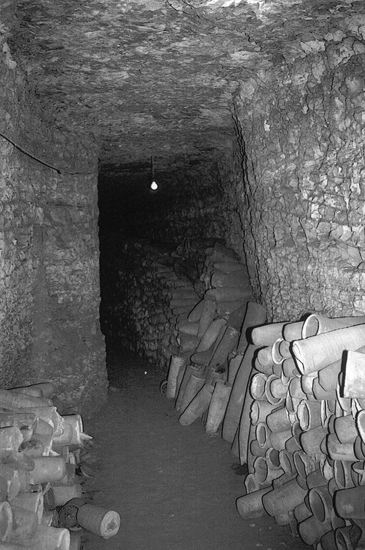
Figure 9.9 View of the gallery with mummified falcons, Saqqara.
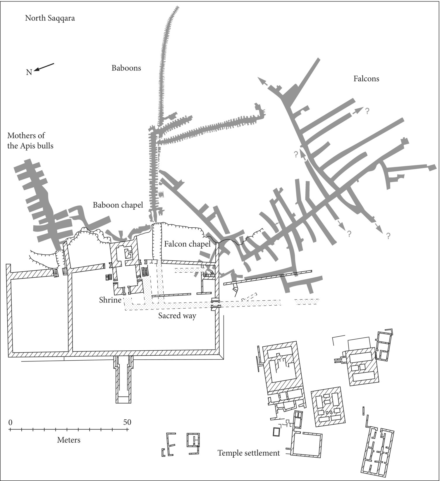
Figure 9.10 Plan of the Sacred Animal Necropolis at North Saqqara.
Source: B. J. Kemp, Ancient Egypt. Anatomy of a Civilization. Abingdon: Routledge. 2006. Figure 132, p. 378. Adapted from H. S. Smith, A Visit to Ancient Egypt: Lift at Memphis and Saqqara c. 500–30 BC, Warminster, 1974, p. 40, Figure 9; p. 33, Figure 7; p. 44, Figure 10; G. T. Martin, The Sacred Animal Necropolis of North Saqqara: The Southern Dependencies of the Main Temple Complex. London: The Egypt Exploration Society, 1981, P1 IA; E. A. Hastings, The Sculpture from the Sacred Animal Necropolis at North Saqqara, 1964–76. London: The Egypt Exploration Society, 1997. Plan 2.
Also in the area of North Saqqara with the animal burials are the remains of a temple complex built in the 30th Dynasty by Nectanebo I and Nectanebo II over an earlier Saite structure. The so-called “Cemetery of Cats” on the eastern edge of the Saqqara escarpment, where Alain-Pierre Zivie has been excavating New Kingdom tombs (see 8.10), was associated with a temple of the cat-goddess Bastet (the Bubastieion), to the north of which were burials of mummified canids associated with a temple of Anubis (the Anubieion). Recently Paul Nicholson (Cardiff University) has been investigating the catacombs of the Anubieion and preliminary examination of some of the mummified animals there by Selima Ikram (American University, Cairo) has identified them as dogs.
Great numbers of pilgrims came to these temples, which supported large communities of priests and other temple personnel. Pilgrims’ petitions to temple oracles were written by scribes, and there were specialists such as astrologers and interpreters of dreams. Much of this evidence is Ptolemaic, and these cults continued to be important in Greco-Roman times. The pilgrims left the mummified animals (both real and faked) as offerings to these cults, which may have been associated with the Osirian cycle of life, death, and rebirth, and associated concepts of fertility and procreation. But cemeteries of mummified animals are known throughout Egypt from late dynastic times onward, evidence that such beliefs had wide followings, not only at Saqqara. Outside the Ramessid Temple of Ptah at Memphis is a site known as the embalming house of Apis, considerably to the southeast of the Anubieion at Saqqara, from where the processional route led westward to the Serapeum. In the 1980s British archaeologist Michael Jones investigated the embalming house, which was first uncovered in 1941 by Egyptian archaeologists Mustafa el-Amir and Ahmed Badawy. The American architect John Dimick, who worked with German Egyptologist Rudolph Anthes in the 1950s, identified the limestone and travertine slabs at the site as the platforms on which the Apis bull was embalmed. Jones suggests that mummification of these huge animals may have taken place there, after which they were probably placed on the stone “beds,” decorated in relief with lions, for purification ceremonies and other rites.
9.7 Some High-Status Tombs of the Third Intermediate Period and Late Period
Although there were periods of great socio-political disruption in Egypt between the Third Intermediate Period and the 27th Dynasty, some high-status individuals built very impressive tombs, especially in the Memphis region in the north and western Thebes in the south. At Buto in the northern Delta there is also recent evidence from this period of two elite burials in stone sarcophagi, which have been excavated by the German Archaeological Institute, Cairo, under the direction of Ulrich Hartung. The larger burial, Grave J2/89, contained an usurped granite sarcophagus, the red granite lid of which has an inscription identifying it as that of an official named Paraemheb, probably from the reign of Rameses II. In between the granite sarcophagus of this burial and the decayed inner wooden coffin was the skeleton of a cat, possibly the pet of the adult male interred there. Jewelry in this burial included a heart scarab made of various materials, including lapis lazuli, and two bracelets of gilded silver inlaid with lapis lazuli and blue glass containing the two cartouches/names of King Iuput II of Leontopolis (23rd Dynasty).
At Thebes during the Libyan dynasties a new type of private tomb was built, which consisted of a small mud-brick temple structure on the Theban plain (and not excavated into the limestone hills, as were those of the New Kingdom), with rock-cut shafts leading to the subterranean burial. These tombs were the prototypes of much more grandiose ones built in Thebes at el-Asasif in the 25th and 26th Dynasties.
As High Steward of two God’s Wives of Amen, Harwa was one of the highest-ranking officials at Karnak in the 25th Dynasty. Located in front of the 11th-Dynasty mortuary complex of Mentuhotep II (see 7.3), Harwa’s large unfinished tomb (TT 37) was the first of a group to be built at el-Asasif over the next 150 years. Italian archaeologist Francesco Tiradritti has recently been restoring and excavating this tomb (Figure 9.11).
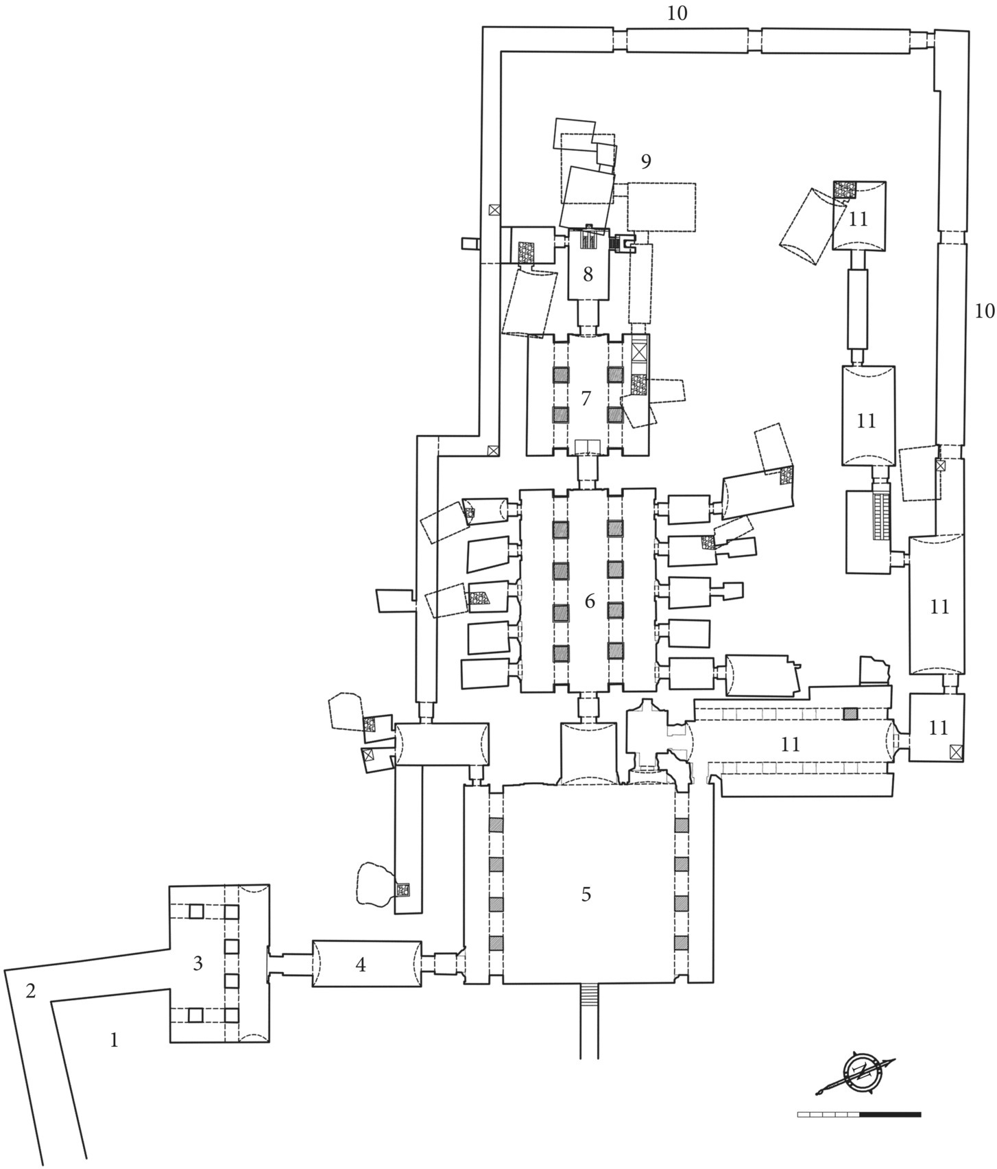
Figure 9.11 Plan of the tomb of Harwa at el-Asasif: (1) quarry, (2) access ramp, (3) entrance portico, (4) vestibule, (5) courtyard, (6) first pillared hall, (7) second pillared hall, (8) Osiris’s shrine, (9) funerary apartment, (10) corridor, (11) tomb of Akhimenru.
Source: Associazione Culturale “Harwa 2001” ONLUS, Montepulciano, Italy. Drawing by Dieter Eigner. Computer-processed by Silvia Bertolini.
At the bottom of a descending passage, Harwa’s tomb opened through an antechamber and vestibule, which led to an open sunken court. From the court the axis of the tomb turned 90° into a series of pillared halls and passageways, which led to a hall with a niche for an Osiris figure in high relief. The burial was at the bottom of a vertical shaft in the second pillared hall. According to Tiradritti, the tomb is modeled on the Osireion at Abydos (see 8.6), and the tomb’s sunken reliefs document Harwa’s passage from daily life on earth to his death and transition to the afterlife.
In the 26th Dynasty el-Asasif continued to be the area in which the highest status tombs were built. The largest el-Asasif tombs were built by Mentuemhat (TT 34, ca. 640 BC), Governor of Upper Egypt, and the Chief Lector Priest Petamenopet (TT 33, ca. 600 BC). Similar in design to (but larger than) Harwa’s tomb, these had large mud-brick superstructures, which emulated New Kingdom royal mortuary temples. Still visible at el-Asasif, the superstructures of the large 26th-Dynasty tombs consisted of three walled courts, fronted by a pylon. The tomb’s sunken court, where daily offerings of the funerary cult were placed on an offering table, was located in the second of the brick courts. The large Saite Period tombs at el-Asasif were robbed not long after their burials and the subterranean chambers were reused for later burials.
In the north high officials of the 26th Dynasty were buried in tombs at Saqqara, Giza, and Abusir, which have acquired the designation “Persian tombs.” These tombs were ingeniously designed with special shafts, probably to lower the heavy nested sarcophagus to the bottom of the tomb. The sarcophagus was placed on top of sand which filled the main shaft, and it was lowered as sand was removed from subsidiary shaft(s). Once refilled with sand, these shafts also foiled tomb robbers. Although their superstructures have been destroyed, some of these tombs remained undisturbed by grave robbers.
In the 1990s a Czech team of archaeologists working at Abusir, led by Miroslav Verner, excavated the late 26th/27th-Dynasty tomb of Iufaa (Figure 9.12). Iufaa was a lector priest and palace official, and the vaulted limestone roof of his tomb was at the bottom of a vertical shaft filled with sand, over 21 meters below the surface. It took three years for Verner’s workers to clear the main shaft and the two vertical subsidiary shafts, also filled with sand, which emptied into the main shaft. In order for robbers to penetrate the burial, several hundred cubic meters of sand from the main shaft, as well as sand from the subsidiary shafts, would first have had to be removed – essentially an impossibility.

Figure 9.12 Plan of the 26th-Dynasty tomb of Iufaa at Saqqara.
Source: Zahi Hawass, “Abusir Tomb,” National Geographic Magazine 194 (5) (1998), p. 107. Reproduced by permission of Kenneth Garrett/National Geographic Creative.
Within Iufaa’s decorated burial chamber (ca. 4.88 × 3.35 meters in area), which was constructed of limestone blocks, the Czech archaeologists found a limestone lid to the sarcophagus that weighed 24 tons. Beneath that was a huge basalt anthropoid sarcophagus, within which were the decayed remains of a wooden coffin which, when removed, revealed a covering of thousands of faience beads. When examined in a laboratory, the mummy was found not to be well preserved, but the fingers were still covered with gold foil.
9.8 Tell el-Maskhuta and Tell el-Herr
Although a well-fortified site of the late New Kingdom was located at Tell el-Retabah in the Wadi Tumilat (eastern Delta), in Saite times the major settlement (and fort) in the wadi was moved east to Tell el-Maskhuta, about 15 kilometers west of modern Ismailia. According to John Holladay, the University of Toronto archaeologist who directed excavations at the site (1978–1985), Tell el-Maskhuta had been a small unfortified Hyksos village in the later Second Intermediate Period. But when the Delta canal through the Wadi Tumilat was begun by the Saite king Nekau II, Tell el-Maskhuta became the wadi’s most important frontier fortress. A large temple of the god Atum was built, to the north of which are the remains of mud-brick houses, granaries, and ovens – probably to be associated with the community of temple personnel and workers.
Possibly following Nekau’s defeat in Syria at Carchemish, a huge defensive wall, 8–9 meters thick and 200 meters long on each side, was built at Tell el-Maskhuta. According to Holladay, two phases of destruction occurred when the site was attacked by the army of the Chaldean king Nebuchadrezzar II, in 601 BC and 568 BC. The fortress was also attacked by the Persian army in 525 BC, after which the settlement inside the walls expanded to cover the entire area of the enclosure. In the Wadi Tumilat the Persian king Darius erected four stelae (inscribed in four languages), about his completion of the Delta canal.
Much imported pottery has been excavated at Tell el-Maskhuta, especially Phoenician and East Greek pottery dating to Saite times and the 60 years of Egyptian rule between the two Persian dynasties. During a rebellion against the Persians in 487 BC a large well outside the fort’s walls was blocked up with refuse, including much pottery. South Arabian silver coins and small limestone incense altars in South Arabian style point to trade with the southern Red Sea region during the 30th Dynasty.
Gaps in occupation occurred at Tell el-Maskhuta at two major junctures in time: when the Persians were ultimately defeated by Alexander the Great, and at the end of the Ptolemaic Dynasty when Egypt became a Roman province. Occupation at the site resumed after the Delta canal was rebuilt, first by Ptolemy II and later under the Roman emperor Trajan.
To the north of the Wadi Tumilat in the northwest Sinai is another fortress, Tell el-Herr, which has been excavated by French archaeologist Dominique Valbelle as part of salvage operations to investigate sites in the region before they were destroyed by new agricultural development. Somewhat smaller than Tell el-Maskhuta, the Tell el-Herr fortress (ca. 125 meters long on each side) was located to the south of the Pelusiac branch of the Nile on an important overland route across the northern Sinai. Four different stages of occupation have been identified at the site, from the first period of Persian domination to the late Roman Period.
The locations of these fortified settlements indicate the importance of the overland route into Egypt across the Sinai – through which invading armies would have traveled – and the new canal route, which was important for sea trade between the Mediterranean world and the Red Sea (and beyond). With the defeat of the Persians Egypt became increasingly connected to powers that were centered on the northern side of the Mediterranean – first with the Macedonian Greeks and the subsequent founding of the Ptolemaic Dynasty, and later with the Roman world.