Chapter 10
The Greco-Roman Period
Greco-Roman Egypt
10.1 The Ptolemaic Period: Overview
With a full-time professional army, the Macedonian king Philip extended his control over Thrace and much of Greece. His son Alexander was only 20 years old when Philip was assassinated in 336 BC, and the new king soon faced the revolt of the Greek state of Thebes, which he put down. Subsequently, Alexander was elected ruler of the Greek states, except for Sparta, and took his army into Asia Minor (what is now Turkey), where he fought the Persian army at the Granicus River. Freeing the Greek cities in Asia Minor from Persian rule, Alexander continued eastward. In 333 BC he defeated the Persian army, led by the last Achaemenid king Darius III, at Issus. Alexander refused a treaty with Darius and took his army south along the eastern coast of the Mediterranean. Conquering the Phoenician port cities there, he cut off the Persian fleet from their homeland. Persian control of Egypt ended in 332 BC when Alexander and his army entered the country.
In Egypt Alexander supposedly had himself crowned king in Memphis. He founded the city of Alexandria, and visited Siwa Oasis in the far west, where he was declared the son of Amen/Zeus by its oracle. Alexander left Egypt in 331 BC, continuing his conquests eastward. The Persian army was defeated in northern Mesopotamia and Alexander later destroyed their capital, Persepolis. He took his victorious army as far east as what is now Pakistan. But ill with a fever, he died in Babylon in June 323 BC – only 33 years old.
After Alexander’s death a series of wars broke out between factions: those who wanted to hold the huge empire together and those who sought to carve out territories for themselves, and later between the emerging independent powers. Three great kingdoms eventually formed: Macedon, the Seleucid Empire (in Syria and Mesopotamia), and the Ptolemaic kingdom (in Egypt and Cyrenaica, now northern Libya). These three kingdoms were to be in competition and conflict with each other for well over a century until matters came increasingly to be decided by the Romans.
The Ptolemaic kingdom in Egypt was founded by Alexander’s governor, Ptolemy, son of Lagus, who became King Ptolemy I in 305 BC. Rulers of the Ptolemaic Dynasty were all his descendants who ruled as pharaohs and did not inter-marry with Egyptians. The last ruler of this dynasty was Cleopatra VII, who committed suicide in 30 BC, after which Egypt became a province of the Roman Empire.
Initially the Ptolemaic kingdom was the most powerful of the three principal kingdoms of Alexander’s former empire, expanding their control outside of Egypt to include Palestine, Phoenicia, Cyprus, Cyrenaica, and parts of the Aegean and Anatolia. To control the eastern Mediterranean – and the lucrative trade routes there – the Ptolemies needed a large navy, which required access to Lebanese cedars for shipbuilding. This brought the Ptolemies directly in conflict with the Seleucids. After a series of six Syrian wars, the only foreign regions that the Ptolemies controlled were Cyprus and Cyrenaica.

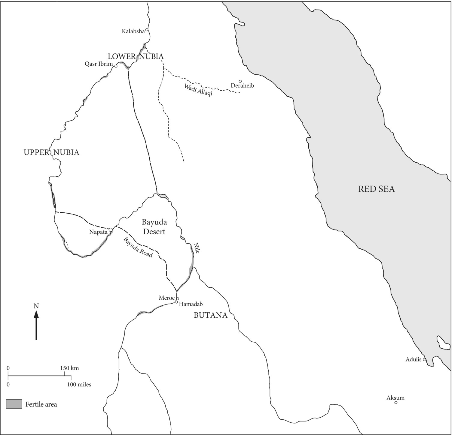
Map 10.1 Greco-Roman Period sites in Egypt, Libya, and the Eastern and Western Deserts.
The Ptolemaic army consisted of Macedonians and people of many different Greek areas, and increasing numbers of mercenaries and Egyptians. Alexander had learned from the Indians to fight with elephants, but Indian elephants were not available to the Ptolemies, who sent expeditions to the Horn of Africa for African elephants. Transported to Egypt on ships called elephantagoi, the animals were used in assaults more or less like tanks in modern warfare. The cost of continued large-scale Ptolemaic military activity abroad, on both land and sea, was of course enormous.
The development that took place in the Ptolemies’ royal city, Alexandria, was also very costly. In Alexandria the Ptolemies built many conspicuous monuments, including a sumptuous palace complex (the Brucheion). A royal architect planned the city on a grid, 30 stadia (5 kilometers) long and 7–8 stadia wide, on a stretch of land wedged between the Mediterranean on the north and Lake Mareotis on the south. The great lighthouse of Alexandria, possibly as high as 135 meters, was built on the western side of the harbor entrance on Pharos Island, which was connected to the city by a long man-made causeway. A main east–west processional road through the city extended eastward to the city of Canopus. Fresh water was supplied to underground cisterns in Alexandria by a canal from the Canopic branch of the Nile.
Ptolemy I founded the Mouseion, a Greek institution of learning which included the famous library, where Greek works were zealously collected from all over the Greek world. Papyri in Egyptian were also collected and the library eventually contained hundreds of thousands of works. Important works were translated into Greek from Egyptian and other languages, including the Hebrew Old Testament, the Septuagint, so called because 70 scholars were supposed to have each made translations. Under Ptolemaic patronage, scholars made advances in science (physics and astronomy), medicine, geography, mathematics (Euclid’s geometry), and engineering, and Greek philosophy and literature were also studied there.
Although many pharaonic monuments were relocated by the Ptolemies to Alexandria, the dominant culture of the city was Greek. Alexandria was renowned throughout the Hellenistic world for its art and monuments, its centers of learning, and an impressive festival called the “Ptolemaieia,” which aspired to be as important as the Olympic Games. The Ptolemies were buried there along with Alexander the Great, whose body was appropriated by agents of the later Ptolemy I and never reached the intended royal place of burial in Macedon. The location of Alexander’s tomb remains unknown.
The Ptolemaic kings were absolute rulers, legitimized as descended from Zeus through Alexander of Macedon, whose bloodline was manipulated to include Ptolemy I. Queens became important co-rulers in this dynasty, in which full brother–sister royal marriages became a regular practice. A kind of cult of the ruler, mainly of the deceased kings, developed in Alexandria, with significance for the Greek subjects of this dynasty.
The Ptolemies actively supported the cult temples of Egyptian gods. In antiquity gods were local, and in a foreign country immigrants needed to relate to the gods of that country. Thus the adoption of local gods by the Ptolemaic rulers was probably the normal course of events. But assuming the Egyptian role as pharaoh – and its ideology – may also have been a means by which the Ptolemies gained a certain amount of socio-political control over the Egyptian population, and the Egyptian cults legitimized them as pharaoh. Through support of the gods’ temples and their rituals, the Ptolemaic pharaoh could expect the gods’ reciprocity – prosperity and well-being for Egypt – as did the Egyptian pharaohs before. But there were also pragmatic reasons for the Ptolemies to support Egyptian cult temples, which were important centers of indigenous support with large-scale economic functions. A large class of priests and temple personnel existed, some of whom had a fair amount of political power, especially the high priests in Memphis.
Notable temples were built and decorated by Ptolemaic kings in formal Egyptian style, with some innovations in details. Some of the best-preserved temples in Egypt today, such as at Edfu and Dendera, were built in Ptolemaic times, as was much of the complex at Philae, at the First Cataract. This was the cult center of the Egyptian goddess Isis, which gained great prominence during the Ptolemaic Period. The Serapeum in Memphis (see 9.6) became a focus of the important cult of Serapis, in which the Egyptian god Osiris, closely associated with the sacred Apis bull, was anthropomorphized as a bearded Zeus-like figure. A Serapeum was also built in Alexandria, and became an important cult center there. Thus a new triad of deities was invented in what successfully syncretized important Greek and Egyptian deities: Serapis (the supreme god and ruler of the underworld), his wife Isis, and their son Harpocrates (the child Horus), all of whom were associated with healing. The cult of Serapis spread throughout the Mediterranean, as did that of Isis.
Perhaps the most famous ancient Egyptian inscription, the Rosetta Stone, was a decree by priests in Memphis in 196 BC honoring King Ptolemy V upon his coronation. Essentially it was an agreement between the Egyptian priesthood and the king (who was 13 years old then) aimed at ending rebellions in the country. The king gave donations to temples and tax remissions, which the priests reciprocated by pledging to erect statues and stelae honoring the king in Egyptian temples.
For a long time only Greeks held the top government positions in Alexandria and the country was administered through its approximately 40 provinces, which in Greek were called nomes, with Egyptians in the local offices. From its inception Ptolemaic Egypt was a country of two different cultures, Greek in Alexandria and the newly founded cities/towns in the Faiyum region, and Egyptian in the rest of the country. There were also increasing numbers of Jews in Egypt, with a large influx around the mid-2nd century BC. Greek and Egyptian law were practiced in different courts. Decreeing laws, the Ptolemaic king also had judicial authority through the highest judge.
Ptolemaic state bureaucracy was well organized, especially for extracting revenues. The economic base of the state remained cereal agriculture, which was elaborately controlled by the government. Although theoretically the king owned all the land in Egypt, temples were also major land-owners. But there were other types of land holdings, including land allotted to soldiers and government officials in reward for their services.
Introduced into Egypt after Alexander’s conquest, free-threshing wheats began to replace emmer wheat. During Ptolemy II’s reign large-scale land reclamation was undertaken in the area around the Faiyum lake, where lake levels had greatly declined, and new towns were founded there. The water wheel, which was introduced into Egypt in late Ptolemaic times, made it possible to lift much greater volumes of water to higher elevations than the bucket and lever lift mechanism (shaduf) introduced in the 18th Dynasty. More intensive cultivation and control of yields thus helped to assure substantial royal revenues.
Foreign trade was another important source of revenue for the Ptolemies. The Delta canal of the Persians was restored and Ptolemaic ships sailed to the southern Red Sea region, not only for war elephants, but probably also for the exotic raw materials that pharaonic Egypt had obtained from Punt. Some ships also ventured to regions along the Indian Ocean, and Alexandria became a major consumer as well as a trading center of exotic imported goods.
Ptolemaic crafts were desired throughout the Mediterranean world and beyond. A type of fused glass bead from Ptolemaic Egypt, made with the design of a human face, has been found in burials at Meroe and at Aksum (in northern Ethiopia). Papyrus grew in Egypt and, as earlier, the manufacture of this plant into a writing material was an important industry in Ptolemaic times. With a higher degree of literacy and writing in the Greek world, papyrus was the most desirable writing material. The English word “paper” is derived from the Greek “papyrus,” which is possibly derived from an Egyptian term for this material.
As in pharaonic times, mining and quarrying in the desert regions were controlled by the state. Although historical sources report that the gold mines in the Wadi Allaqi (to the east of Lower Nubia) were reopened in Ptolemaic times, investigations of these sites have demonstrated that Ptolemaic gold mining was confined to the central Eastern Desert of Egypt, at sites mined in the New Kingdom. Two Ptolemaic coins have been found at the site of Deraheib in the eastern Wadi Allaqi (in the Eastern Desert to the east of Lower Nubia and only 75 kilometers from the Red Sea). There is much evidence of gold mining in this region, but pottery at the site suggests that it was occupied later, mainly in Byzantine times (post-3rd century AD). Remains include a planned settlement and two fortresses.
The decline of Ptolemaic rule in Egypt occurred gradually. Power conflicts between Ptolemaic siblings sometimes led to murder, and the mob in Alexandria played a role in this. Increasingly, Rome intervened in the Ptolemies’ conflicts. Civil unrest, civil war, economic breakdown, corruption – all occurred during the reigns of the later Ptolemies. Nonetheless, temple building and decoration continued in Egypt on a large scale.
Rome gained control of Cyrenaica in 96 BC, and of Cyprus in 58 BC, although these countries briefly reverted back to Egyptian control during what was supposed to be the co-regency of Cleopatra VII and her brother Ptolemy XIII. But Ptolemy XIII died in battle against Julius Caesar, who had a relationship with Cleopatra. Ptolemy XIV was made co-ruler with his sister Cleopatra, but after Caesar’s assassination in Rome, she had this brother murdered. With the defeat of Cleopatra’s lover and political ally Marc Antony at Actium in 31 BC, this female ruler and her son by Caesar, Ptolemy XV Caesarion, both perished. They were the last Ptolemaic rulers of Egypt.
10.2 The Roman Period: Overview
At the top Roman Egypt was ruled quite differently from Ptolemaic Egypt. Most Roman emperors never visited the country, which was governed by a well-organized bureaucracy headed by the prefect (a viceroy/governor). The prefect was Roman, of high (equestrian) rank, who was appointed by the emperor. The country was greatly exploited for its resources, especially its agricultural wealth, with Egypt providing as much as a third of the grain for the city of Rome, to support its disenfranchised population.
Roman citizens were of the highest social status in Roman Egypt. Below them was a social class made up of inhabitants of the four major Greek cities: Alexandria, Naukratis, Ptolemais (in Upper Egypt), and later Antinoöpolis, the only new city founded in Egypt by the Romans. (During Hadrian’s visit to Egypt in AD 130–131 his lover Antinous drowned in the Nile, and the emperor founded the city in commemoration of this young man.) The third social class consisted mainly of Egyptians and all others who were not of the two higher classes. All Egyptian males (14–62 years old) had to pay an annual poll tax, but among this class the metropoleis, who were higher-status residents of the chief nome towns, paid reduced rates. At the bottom of the social strata was a large class of slaves.
Alexandria was the center of Roman Egypt, where the Romans built temples and other public monuments, and existing sites on the Mediterranean coast to the east and west of the city were also occupied. As the great commercial center of Roman Egypt, Alexandria had numerous warehouses in its harbor area, and huge granaries must have existed which supplied the grain ships that left for Rome every year in May or June. Although little is known archaeologically about its industries, Alexandria was certainly an important shipbuilding center. Highly desired craft goods, especially papyrus, linen, and glass vessels and beads, were produced there. Jewelry in gold or silver with imported gems, and other metal artifacts, including lamps and vessels in silver or bronze, were also made there. Pottery was made not only for indigenous use, but also for export, including containers for wine produced in the region.
For administrative purposes, Egypt was divided into four major regions, each of which was headed by an epistrategos, who was a Roman of equestrian class. As in Ptolemaic Egypt, the country was further divided into smaller units of nomes, which were administered by strategoi, who were Greco-Egyptians. One of the nome capitals, Oxyrhynchus in Middle Egypt, has provided a huge amount of information about local administration, recorded on well-preserved papyri. From 1898 to 1908 over 100,000 fragments were excavated by two British scholars, B. P. Grenfell and A. S. Hunt, in rubbish mounds of the ancient town, over 6 meters deep.
Oxyrhynchus is so named because a sacred fish with a pointed head was worshipped there. The Oxyrhynchus papyri include texts with information about daily life and economic affairs in the town, and also a large collection of literary works in Greek (as well as some lost works of history and philosophy), and a few in Latin. More than 100 years since their discovery, papyri from Oxyrhynchus continue to be reconstructed from fragments and translated at Oxford University, under the direction of Dirk Obbink, with 77 volumes published thus far. New imaging techniques, such as MSI (magnetic source images), have helped to enhance the reading of these texts.
Roman control of Egypt was first enforced by three legions of the army (later two), along with auxiliary troops and cavalry units. Garrisons were placed throughout the country with forts and stations along desert routes. Essentially the troops were there to ensure Roman governance of the population, extraction of taxes (the grain tax) and other resources (including gold mined in the Eastern Desert), and protection of the desert routes leading from quarries and from ports on the Red Sea. Roman troops in Egypt were also used in military campaigns to the east, such as against the Jewish revolts in the 1st and 2nd centuries AD, and the conquest of Arabia.
But even with the substantial Roman military presence in Egypt, there were still internal rebellions, with especially unfortunate consequences for Alexandria. In the 1st century AD conflicts occurred in the city between the Greeks and the large Jewish population there; many Jews were violently killed and their synagogues attacked. As a result of the Jewish revolt in AD 115–117, which began in Cyrene and spread east, huge numbers of Jews were slaughtered, not only in Alexandria but also throughout Egypt. During the reign of Marcus Aurelius, a revolt occurred in the Delta (171–172), brought on by a widespread plague. In 215, during Caracalla’s visit to Egypt, the emperor ordered the youths of Alexandria to be slaughtered. Queen Zenobia of Palmyra (Syria) conquered Egypt in 270, with much damage to Alexandria when the Romans retook the country. Another rebellion occurred during Diocletian’s reign, with Alexandria under siege for eight months (296–297).
In the far south of Egypt, when Roman troops were withdrawn from Syene (Aswan) in 24 BC for the Arabian campaign, the city was sacked by the Kushites. Syene had been the negotiated boundary between the two powers, and Roman forces of Gaius Petronius invaded Nubia. Qasr Ibrim, where the 25th-Dynasty Kushite king Taharqo had built a mud-brick temple, was fortified by the Romans, and their army moved upstream, sacking the religious center of Napata. Eventually the Kushites, whose capital was at Meroe, sued for peace with Augustus, and the border was extended about 100 kilometers south of Aswan. Large-scale Roman reoccupation of Lower Nubia occurred, and there are several temples which date to Augustus’s reign. Qasr Ibrim, about 238 kilometers south of Aswan, was occupied by the Kushites and the site became a major Meroitic center.
Meroe continued to be the seat of the kingdom, with royal pyramids built in cemeteries to the east of the city. But by ca. AD 350–360 this very long-lived state had collapsed. Graffiti in Ge’ez, the written language of the Aksumite state, located in what today are northern Ethiopia and Eritrea, have been found at Meroe – evidence of an Aksumite raid there. It is likely that with the development of Roman trade with southern India via the Indian Ocean and Red Sea, Meroe became more marginalized as a source of the exotic raw materials from the Horn of Africa, as Aksum’s seaport of Adulis became the port of call.
In Ptolemaic times ports were founded on the Red Sea, especially during the reign of Ptolemy II. These included Berenike and Myos Hormos (probably the site of Quseir el-Qadim), which were reached via desert routes from Coptos and Edfu in Upper Egypt. In Roman times trade goods from the southern Red Sea region and India, as well as quarried stone from the Eastern Desert, were carried overland via the desert routes to the Nile and then taken downstream by ship or barge to Alexandria. Along these desert routes the Romans built posts and dug deep wells, still visible today. Two desert routes from Qena passed near the important quarrying sites of Mons Porphyrites and Mons Claudianus. At Mons Porphyrites imperial purple porphyry was quarried – the only known source of this rock in the world. Used in major Roman monuments, purple porphyry can still be seen as reused columns in early churches in Rome. Mons Claudianus was the source of a special grey granodiorite, while the pharaonic granite quarry at Aswan also continued to be exploited by the Romans.
In the Western Desert the Romans exploited the oases (especially Kharga and Dakhla) for their produce. At Dakhla Oasis nearly 250 sites that date to the 1st–5th centuries AD have been located. Irrigation farming was practiced intensively throughout the oasis and evidence of huge aqueducts has been found at Deir el-Haggar, extending from spring mounds to the area of cultivated fields. Bahariya Oasis was also farmed during the Roman Period, and archaeologists of the Supreme Council of Antiquities (SCA) have been excavating a huge cemetery there with multi-chambered rock-cut tombs for possibly thousands of mummies, many of which were buried in family groups. Although some decorated tombs in Bahariya Oasis date to the 26th Dynasty, the Roman Period ones come from an area popularly known as the “Valley of the Golden Mummies.” Gold foil still covers the masks of the higher-status burials, which have not been robbed.
The Roman Period burials at Bahariya Oasis demonstrate the continuing importance of ancient Egyptian mortuary beliefs. Decoration on a female mummy from Tomb 54 (Mummy B) includes images of protective Egyptian deities, and although the hairstyle is Roman, the clothes are Egyptian in style.
At Hawara in the Faiyum Flinders Petrie excavated a large number of intact mummies from the Roman Period that were buried in coffins decorated with images of Egyptian gods and scenes relating to the mortuary cult, but with inset portraits painted on wooden panels (the “Faiyum mummy portraits”). Other similar coffins have since been found in other parts of Egypt. In these portraits the deceased is shown with Roman dress and jewelry, painted in an illusionistic style that is Greco-Roman and not Egyptian. In Alexandria, high-status burials in a complex of underground tombs and chambers of the Kom el-Shuqafa, which date to the 2nd century AD, also show a mixture of Egyptian and Greco-Roman architecture, decoration, and mortuary beliefs.
Under the Romans construction and decoration of Egyptian temples continued, and some earlier structures were repaired, including the Giza Sphinx. On temple walls Roman emperors were portrayed as Egyptian pharaohs honoring the gods and their names were carved in hieroglyphs in cartouches. Several Egyptian cults were popular throughout the Roman Mediterranean world outside of Egypt – including Rome. The cult of Isis, which had been popular outside of Egypt in Ptolemaic times, continued to be so in Roman times. But the Romans in Egypt also had temples of their own deities, and there were Greek cults which had not been syncretized with Egyptian ones. Egyptian priests continued to be trained to read Egyptian religious texts and perform temple rites, but there was a decrease in temple support and in the status of these priests.
Although persecuted by the Romans, Christianity by the late 2nd century was becoming increasingly accepted in Alexandria, where the local schools of Greek philosophy influenced the development of early Christian thought. In the next century the new religion spread throughout Egypt. When the emperor Constantine decreed the Edict of Toleration in 311, the religion gained legal status in the Roman Empire. There were certainly conflicts in Egypt between Christians and worshippers of the traditional cults, and Christianity was still not widely accepted. But Christians were intolerant of pagan religion, and in 392 the emperor Theodosius decreed that Egyptian temples be closed – which actually occurred more gradually over the next two centuries.
Egyptian Christians used the Coptic alphabet, based on the Greek one, to write their spoken language – the last phase of the language spoken by the pharaohs. The last known hieroglyphic text was written at Philae in 394, with the last demotic text there dating to 452. Although a treaty was made in 451–452 with the Blemmyes and Nobadae, tribal groups of the Eastern Desert and Nubia, allowing them to continue worshipping there, Philae was finally converted into a church by ca. 575.
Christianity brought about the end of pharaonic Egypt – there were no more pharaohs who patronized the cults of Egyptian gods in temples with walls inscribed in the “sacred writing” of hieroglyphs, the most tangible and recognizable evidence of this very long-lived civilization. Christian beliefs of the afterlife were also very different from ancient Egyptian ones, and the concept of a mortuary cult with associated deities was alien to Christians. The monastic movement was invented in Egypt, with monks living in isolated places, including ancient tombs, which had been robbed long before. Alexandria, the great center of learning and cults of Greco-Roman Egypt, became the seat of the church Patriarch.
Despite over 1,000 years of intermittent rule and conquest of Egypt by foreigners, from the Kushite kings of the 25th Dynasty to the Roman emperors, pharaonic civilization was visibly present throughout Egypt. Under Roman rule there was a decline of state support for temples and the indigenous elite, but the cults of pharaonic gods continued to be practiced. Foreign conquest did not bring Egyptian civilization to an end; this occurred with the increasing acceptance in Egypt of a new monotheistic religion that was intolerant of many – and all other – gods.
10.3 Alexandria
Alexandria suffered much destruction in the political disruptions of the later 3rd century AD. After riots between pagans and Christians in 391, the great Serapeum temple was destroyed, and many temples were eventually converted into churches. Earthquakes also took their toll in Alexandria, including major parts of the harbor-front, which are now submerged. When the invading Muslim army entered the city in 642, however, there was still much impressive monumental architecture. As Alexandria became an Islamic city more rebuilding occurred when many churches were transformed into mosques. Today with many ancient remains covered by the modern city (thus precluding excavation), much of what is known about the Greco-Roman city is from textual information, especially descriptions of the Greek geographer Strabo, who visited Alexandria in the early years of Roman rule.
The first systematic excavations in Alexandria were ordered in 1866 by the Khedive of Egypt. They were conducted by Mahmud Bey, who later published a plan of the Roman Period city, with streets, canals, and the city wall (Figure 10.1). Another map of the city in the late 19th century, locating the known ancient remains, was also published by Mahmud Bey. With the founding of the Greco-Roman Museum in Alexandria in 1892, observations and excavations of ancient remains there have been conducted under the museum’s auspices.

Figure 10.1 Plan of the city of Alexandria.
Source: Ian Shaw (ed.), The Oxford History of Ancient Egypt. Oxford: Oxford University Press, 2000, p. 406. Used by permission of Oxford University Press.
Ancient Alexandria was a Greco-Roman city, with little Egyptian-style architecture, as is evident from the excavations of the Polish Center of Mediterranean Archaeology (Warsaw University) on the Kom el-Dikka. Roman baths (3rd century) have been uncovered with rooms for warm and cold baths and a steam-room, near a complex of cisterns which stored water underground. Located near this complex was a Greek-style theater with white Italian marble columns (4th–7th centuries), which has been restored. (A number of theaters are known in the city from textual sources, and the Roman city also had a hippodrome, where chariot races continued to be a great public spectacle in Byzantine times.) In this area the Polish archaeologists have excavated large houses (villa urbana) dating to the 1st–3rd centuries, which were subsequently replaced by smaller ones of the 4th–7th centuries. They have also uncovered the first evidence of Alexandria’s university – a building with 13 lecture halls, each arranged with stepped benches on three sides of the room.
Impressive monumental finds, which may have formed part of the lighthouse complex, have been excavated at an underwater site to the east of the Islamic Qaitbay Fort by Jean-Yves Empereur, Director of the Centre d’Études Alexandrines (Plate 10.1). These include Ptolemaic royal statues and pharaonic monuments, such as obelisks, sphinxes, and columns, many of which were taken from Heliopolis. Remains of an earlier Greek city, Herakleion/Thonis, have also been located at an underwater site in the Bay of Abukir, about 22 kilometers east of Alexandria, where Admiral Lord Nelson defeated Napoleon Bonaparte’s fleet in 1798. The sea finds from Herakleion suggest that Delta temples could have been built on a very large scale – which is not known from the preserved evidence of temples on land.
Empereur has also done rescue excavations in the Gabbari district of Alexandria (to the west of the ancient city), where a burial complex was discovered during the construction of a highway. Forty-three tomb complexes for multiple burials were located – one of which contained ca. 250 rectangular burial niches cut in the bedrock (Plate 10.2). Sometimes as many as 12 skeletons were found in one niche, the earlier ones simply being shoved aside for a later burial, and the niche was closed off by a stone slab. These tombs were destroyed, however, when the site was bulldozed and construction began on the Gabbari bridge in 2000.
The rescue excavations in the Gabbari district tombs uncovered thousands of ceramic lamps and vessels, as well as other artifacts associated with Greek mortuary rites. Although Empereur also found some Egyptian mummies with gold foil on the faces of their cases, these catacomb tombs seem to have been used mostly by Alexandrines who adhered to Greek (and not Egyptian beliefs) about burial and the afterlife, with Greek inscriptions identifying some of the occupants. Cremation burials in urns were also found – a distinctly non-Egyptian type of burial known in the Greek (and later Roman) world. Cross motifs on artifacts and in wall niches identified the later reuse of some of the tombs by early Christians.
Large, multi-roomed tombs for multiple burials of high-status persons are known elsewhere in Alexandria, such as at Shatby and Kom el-Shuqafa, and along the coastal region to the west of the city. The rock-cut substructures of these tombs often contain elements of Greek then Roman funerary architecture, as well as Egyptian temple architecture – and decorations, both painted and in relief, that combine Egyptian symbols and scenes pertaining to the afterlife with classical motifs.
10.4 Greco-Roman Settlements in the Faiyum
A number of the new settlements that were founded in the Faiyum region during the reign of Ptolemy II continued to be quite prosperous in Roman times. Both illicit and legitimate excavations of these sites have yielded huge numbers of well-preserved papyri and ostraca with texts in Greek, Demotic, and Coptic.
Also from the Faiyum come the famous “Faiyum mummy portraits,” excavated by Flinders Petrie in a large Roman Period cemetery to the north of a Middle Kingdom pyramid (Amenemhat III’s) at Hawara (Plate 10.3). But other contemporaneous burials that were more traditionally Egyptian in decoration were also excavated in this cemetery. A Ptolemaic cemetery that Petrie excavated at the mainly pharaonic site of Medinet Gurob in the Faiyum yielded many Greek and Demotic texts, from private letters and wills to works of the Greek classics. The papyri were reused (and thus preserved) as the underlying material for the cartonnage mummy cases, otherwise usually made of plastered cloth.
After spectacular finds of papyri in 1899–1900 by Grenfell and Hunt, the site of Tebtunis (Tebtynis) on the southern edge of the Faiyum was excavated early in the 20th century by German and then Italian archaeologists. More recently a French–Italian team (the French Institute of Archaeology in Cairo and the University of Milan) has been excavating the site, and in an ancient dump they have uncovered ca. 6,000 texts, mostly in Greek and Demotic, on papyri and ostraca. There are also hieratic (Egyptian) papyri, and texts in Aramaic, the Near Eastern lingua franca, have revealed the existence of a Jewish community at Tebtunis in the 2nd century BC. Founded in the Middle Kingdom, the town gained importance in the Greco-Roman Period when it was an administrative and economic center, with a cult temple of the crocodile god Soknebtunis. A major center of Egyptian culture in Greco-Roman times, the town has yielded the most important provenanced finds of late literary texts (in Demotic). The town continued to be occupied until the mid-13th century AD.
Finds from the recent Tebtunis excavations include many rolled papyri, still sealed with lumps of clay, that were addressed to the temple oracle – frequently asking the oracle to identify thieves. A demotic papyrus in the Cairo Museum that describes the Soknebtunis temple led the excavators to the discovery of a large processional way (dromos), 14 meters wide, along part of which about 100 sheep and goats were buried in small graves near the temple, as offerings in the 1st–2nd centuries AD. To the east of the temple, well-preserved houses dating from the 3rd century BC to the 2nd century AD have been excavated, including a 2nd-century BC baker’s house with the remains of four ovens and three granaries. To the west of the temple and within the foundations of a Roman ”tower house” were the remains of public baths of the 3rd century BC with limestone tubs. In the late 2nd century BC new baths were built nearby that included bathtubs and smaller basins, with groups of rooms for men and women.
Italian archaeologists have also been working in the southwestern Faiyum region at Medinet Madi, the site of the Greco-Roman town of Narmouthis. The site was excavated early in the 20th century, with large-scale excavations conducted by the University of Milan, 1934–1939 and from 1966 onward; the later excavations have been directed by Edda Bresciani (University of Pisa). This was also the site of a Middle Kingdom temple, and the town continued to be used in Byzantine times (at least seven churches were built) and well after the Muslim conquest. Recently the Roman military camp (castrum) there was located using a satellite image, and excavations began in 2006. The 50-meter-square castrum had mud-brick walls almost 4 meters thick and a vaulted cistern cut deep into the bedrock that was connected to a sophisticated hydraulic system for supplying it with water.
Many Demotic and Greek texts have been found in Narmouthis, as well as later Coptic and Arabic ones. Ptolemaic temples there included one where crocodiles were kept in a special room. Cults of crocodile deities were quite prominent in the Faiyum, and many mummified crocodiles, from babies to adults, have been found in Greco-Roman cemeteries in the region.
In the northeastern Faiyum, the town of Karanis was founded by Ptolemy II. Although some parts of the town had been destroyed by sebbakh diggers, excavations from 1924 to 1935 by the University of Michigan/Kelsey Museum of Archaeology (first under the direction of J. L. Starkey, and later by E. E. Peterson), revealed strata of well-preserved mud-brick houses, some with paintings still on the plastered walls. Large Roman “tower houses” two to three stories high were sometimes preserved, often with vaulted underground storage rooms. Similar houses have been found at other Greco-Roman settlements in the Faiyum, including the one at Tebtunis. Largely unpublished finds by Cairo University excavations at Karanis (1966–1975) include Roman baths as well as houses.
The artifactual evidence from the American excavations at Karanis, along with the many excavated papyri and ostraca, provide much information about daily life of non-elites from the 3rd century BC to the 6th century AD. Household artifacts, such as baskets, ovens, grinding stones, and storage jars, were found in situ inside the houses or in their courtyards. Many of the 27,000 coins came from hoards – attesting to economic insecurity. Excavated textiles were so well preserved that a study was done on 3,000 samples, providing a chronological sequence and information about weaving techniques, and locally produced textiles versus imported ones. Because of the Kelsey Museum’s documented excavations at Karanis, of well-preserved domestic contexts and associated texts, detailed socio-economic studies, such as have been done for the New Kingdom workmen’s village of Deir el-Medina (see 8.11), should yield interesting results for Karanis.
In 2005 the UCLA-RUG Fayum Project (of the University of California, Los Angeles, and the Rijksuniversiteit, Groningen, the Netherlands) began a site-management project at Karanis. Since the earlier American excavations there did not backfill the excavation trenches, much erosion of structures has occurred since the 1930s, and the new project includes making a virtual reality model of the site as well as investigations directed at conservation of the remaining architecture. New excavations in areas where the University of Michigan project did not excavate have uncovered one of the largest known granaries as well as a domestic context in the central part of the site with archaeobotanical and zoological material.
The Greco-Roman towns in the Faiyum were basically organized around a temple and its processional way (dromos). Some of these towns show strict orthogonal planning from the earliest phase of Ptolemaic building, with grids of, north–south and east–west streets. Other towns in the Faiyum were less strictly organized along the dromos. According to Wolfgang Müller, the latter type consisted of towns with houses located along secondary streets which were parallel to or crossed the dromos, or more frequently, towns with houses organized more agglutinatively around the temple precinct,
10.5 Two Greco-Roman Temple Complexes in Upper Egypt: Dendera and Philae
The Greco-Roman temples discussed here are a very small sample. Basically much of what has survived are provincial temples built of sandstone in the far south of Egypt and in Nubia. Blocks of temples built in limestone farther north in Egypt were often recycled, and the southern temples have a disproportionate prominence in the evidence.
Dendera was the capital of the 6th Nome of Upper Egypt. Although temples were constructed there from the Old Kingdom onward, the buildings visible there today date to Greco-Roman times (Figure 10.2). The main temple was built for the cult of the goddess Hathor, with a much smaller temple for (the birth of) Isis to the south.

Figure 10.2 Plan of the Greco-Roman temple of Hathor at Dendera.
Source: Ian Shaw (ed.), The Oxford History of Ancient Egypt. Oxford: Oxford University Press, 2000, p. 440. Used by permission of Oxford University Press.
Flinders Petrie did a survey at Dendera in the late 19th century, and excavations were conducted there 1915–1918 by Clarence Fisher of the University Museum, University of Pennsylvania. The French Archaeological Institute, Cairo (IFAO) later mapped the temple enclosure and the cemetery, which includes important tombs of the Old Kingdom and First Intermediate Period. Auguste Mariette was one of the early scholars to study the temple inscriptions, with systematic publication of the inscriptions in the 20th century by French scholars Émile Chassinat, François Daumas, and Sylvie Cauville. Architectural studies of the Hathor temple have been conducted by Pierre Zignani.
The Dendera temple was surrounded by a huge mud-brick wall, entered through a gate on the north side, which was built during the reigns of the Roman emperors Domitian and Trajan. Most Egyptian temples were oriented toward the Nile and the unusual orientation of this temple (facing north) is due to the bend in the river, which flows from east to west there.
The temple’s ground plan is of classic formal design, with outer and inner hypostyle halls leading to an offering hall and sanctuary, which are surrounded by 11 chapels. The courtyard and northern wall are unfinished. To either side of the offering hall are staircases leading to the inner temple’s roof, where there are rooms dedicated to the cult of Osiris. The ceiling of one of these chapels was decorated with the famous “zodiac” relief, removed by Napoleon Bonaparte’s expedition and now in the Louvre Museum (Figure 10.3). Recent research demonstrates that the Dendera priests had a sophisticated knowledge of astronomy: rites inaugurating these chapels took place on December 28, 47 BC, on the day of a full moon at zenith – a conjuncture that only occurs every 1,480 years.

Figure 10.3 The Ptolemaic zodiac relief from the ceiling of a small chapel in the Temple of Hathor, Dendera, now in the Louvre Museum, Paris.
Source: Musée du Louvre, Paris, France/The Bridgeman Art Library.
The inner temple was built in late Ptolemaic times. Many cartouches there were never inscribed with kings’ names – reflecting conflicts in the royal family. Decorated “crypts,” rooms and spaces for storing temple equipment and texts, were located in this part of the temple, within the outer wall.
On the temple’s southern exterior wall are reliefs of the last Ptolemaic rulers, Cleopatra VII and her son by Julius Caesar, Ptolemy XV Caesarion. The temple’s northern façade, behind which is the outer hypostyle hall, was dedicated during the reign of Tiberius.
To the northwest of the temple are four buildings: a “sanatorium,” two “birth” houses, and a church. The sanatorium was where visitors came to be magically healed, either through bathing in sacred water, or incubation – hopefully dreaming of the goddess’s healing while sleeping there. Birth houses (mammisi), were built within temple precincts to celebrate the divine birth of the deity’s offspring, in this case Hathor’s son Ihy. The earlier birth house at Dendera is Ptolemaic, but was begun during the Late Period. The later one dates to the 1st century AD, built under Augustus and decorated during Trajan’s reign. The early Coptic church, which is located between the two Dendera birth houses, dates to the 5th century.
Philae Island at the First Cataract was the site of a very impressive temple complex built mainly in Greco-Roman times (Plate 10.4). The temples were submerged after construction of the first Aswan Dam, and after the Aswan High Dam was built in the late 1950s plans were made by UNESCO to move the entire Philae complex to higher ground on nearby Agilkyia Island. But even before the temples could be dismantled, the entire complex had to be surrounded by a huge coffer dam and water was pumped out. The rebuilding was finally completed in 1980, and the Philae temples can now be seen in the same relative arrangement as on Philae Island.
One fortuitous aspect of this project is that as the Philae temples were dismantled, earlier structures and reused blocks were revealed, extending back in time what is known about the temple complex. Although the earliest dated monument on Philae was a small 26th-Dynasty kiosk of Psamtek II, even earlier mud-brick houses on the island’s west side may date to the 25th Dynasty (Kushite). Another Saite king, Amasis, built a small temple on the island. The last indigenous ruler to build there was the 30th-Dynasty king Nectanebo I, who erected a monumental gate and a large kiosk, later dismantled and re-erected overlooking the river on the island’s southwestern side.
With the Ptolemaic Dynasty Philae became a great cult center for the goddess Isis. To the north of Amasis’s temple, a new temple was built with scenes and inscriptions of Ptolemy II on the interior. In the temple’s sanctuary, the stand for the goddess’s bark is inscribed with the cartouches of Ptolemy III and his wife Berenike. This king’s name also appears in the oldest parts of the mammisi, similar to that at Dendera, which was erected to the southwest of the Isis temple.
With the dismantling of Amasis’s temple, a space was cleared for a colonnaded area and a pylon, which were added onto the southern side of the Isis temple. The old mud-brick enclosure wall was also removed and the great (first) pylon was built to either side of Nectanebo’s gate by Ptolemy VI. During the reign of Ptolemy VIII the mammisi was enlarged, and decoration of the exterior walls continued into the Roman Period.
Other structures in the Philae complex include temples of Hathor and Horus the Avenger (Harendotes). There is also a Ptolemaic temple for the Nubian deity Arensnuphis (later converted into a church), and a chapel for the deified Imhotep (Asklepios), the 3rd-Dynasty architect of Djoser’s Step Pyramid at Saqqara. Two nilometers were carved in the rock on the western side of the island, to measure the height of the annual Nile flooding there.
During Roman times a considerable amount of building was undertaken at Philae. Under Augustus eastern and western colonnades were built to the south of the first pylon, and a temple was erected on the north side of the island. A gateway to the west of the main temple was built under Hadrian, and a gateway and quay were built on the island’s northeastern side under Diocletian. Perhaps most impressive architecturally is the kiosk of Trajan, with 14 columns between which are screen walls with huge stone architraves above (Plate 10.5).
Although the Blemmyes and Nobadae were allowed to continue to worship in the Philae Temple of Isis (in an agreement of 451–452), two churches on the northern side of the island co-existed with the temple. In the later 6th century the temple’s columned hall was finally converted into a church.
Sites Outside the Nile Valley
10.6 The Western Desert: Bahariya and Dakhla Oases
In Greco-Roman times Bahariya Oasis was an important stop along the routes that crossed the Western Desert – used for both commercial and military activities. Alexander the Great may have passed through this oasis after he had visited the oracle in Siwa Oasis. A temple at Ain el-Tabinieh in Bahariya Oasis is carved with reliefs of Alexander presenting offerings to Amen, and his name appears in cartouches.
About 45 kilometers south of Bahariya Oasis on the route to Farafra Oasis is the town of el-Haiz, which was briefly investigated in 1940 by Egyptian archaeologist Ahmed Fakhry. Excavations there by the Supreme Council of Antiquities (SCA) have uncovered the mud-brick remains of a large Roman Period fortress, next to which is a Roman “palace.” Also at this site (Ain el-Rees) are a Roman Period cemetery, which has only been partially excavated (in 1900), and an early Coptic church.
In Roman times Bahariya Oasis was a wine-producing region, although more favored wines came from Dakhla and Kharga Oases. At Bahariya Oasis evidence of a winery has been found to the west of the Roman fortress at Ain el-Rees, where Egyptian archaeologists have identified concentrations of grape seeds and sherds of wine jars. According to Zahi Hawass, who directed the SCA excavations in Bahariya, the largest room in this building was where the grapes were sorted and then washed. The better-quality fruit would have been taken to a processing room, with a depression in the center where the grapes were pressed. There are also the remains of a series of spouts, channels, and basins for making different mixtures/types of wine.
The large Greco-Roman cemetery at Bahariya Oasis, known as the “Valley of the Golden Mummies,” was accidentally discovered in 1996 when an SCA guard of Alexander the Great’s temple was crossing the site and his donkey stumbled in a hole – which turned out to be a tomb. Five tombs have been excavated containing 105 mummies and many more are expected to be uncovered. According to Hawass, the mummies date from the time of Alexander to the 4th–5th centuries AD, based on decoration found on them and tomb types. The tombs were carved in the sandstone bedrock, with niches along the sides of a main corridor where the mummies were placed side by side (and if these were full, on the tomb’s floor). The larger tombs were entered by a rock-cut staircase. One tomb consists of a vertical shaft with four chambers at the bottom, the entries of which were carved in the style of a Greek temple – a simpler version of the much more elaborate 2nd-century tombs of the Kom el-Shuqafa in Alexandria.
Four different types of mummies have been found at Bahariya, which probably relate to their socio-economic status (but may also reflect changes through time). Of the 105 mummies, 60 have gold-covered masks on their cartonnage casings (plastered and molded linen), and some of them are decorated with gold foil over the chest – these are the highest-status burials (Plate 10.6). The next level of burial consists of mummies wrapped in linen with cartonnage over the upper parts – decorated with painted facial features and images of Egyptian deities. A third type of burial was wrapped in linen that was often arranged in geometrical patterns, but with no painted cartonnage or other decoration. The lowest-status burials were poorly wrapped in linen. In the future it will be useful to have age/sex data for these mummies, as well as paleopathological analyses to identify prevalent diseases, nutritional deficiencies, evidence on bones of stress or accidents, and causes of death. DNA studies may be able to determine genetically related individuals and possibly some diseases.
During the Roman Period Dakhla Oasis, to the south of Bahariya and Farafra Oases, was also extensively occupied. Since 1978 the Canadian Dakhleh Oasis Project (DOP), directed by Anthony Mills, has been conducting yearly archaeological investigations there of hundreds of sites, from clusters of Lower Paleolithic stone tools to medieval Islamic structures. Nearly 250 sites dating to the Roman Period have been located, including three large towns, farmhouses, more than 20 temples, industrial sites – and of course rock-cut tombs and cemeteries. A number of these sites have been very well preserved by sand dunes, which covered the structures and preserved their abandoned organic (and inorganic) artifacts. In Roman times the oasis was exploited for its agricultural wealth, and it is likely that as the sand dunes encroached upon human settlements the site was abandoned because of decreasing agricultural yields.
In 1986 the DOP began excavations at the large town site of Ismant el-Kharab (Kellis in Greek), under the direction of Colin Hope (Monash University, Melbourne). In the eastern part of the oasis, Kellis was the cult center of the god Tutu, the son of the goddess Neith – and “Master of Demons.” The temple was built of stone, with shrines (including a mammisi) and storerooms of mud-brick. Sandstone altars are still standing in the temple’s forecourt. In two of the shrines were well-preserved wall paintings, and recent conservation of the paintings in the mammisi (Shrine I) under the direction of Olaf Kaper (Leiden University) has revealed that different parts of this shrine were painted in two different styles: pharaonic and Roman.
In the central part of the town are a number of mud-brick houses with courtyards that were built in blocks, many of which have been preserved up to their roofs.
Rectangular rooms were barrel-vaulted, and on the interior walls there were niches, shelves, and cupboards (without wooden doors, which had been removed). Four houses which have been excavated can be dated to the late 3rd to late 4th centuries AD, based on dated coins, dates which appear in texts of contracts, and the types of ceramics excavated.
Recently at the northern end of the town (Area B) Hope has excavated a large, multi-roomed residence in which well-preserved wall paintings have been revealed, with two rooms containing fragments of plaster sculptures of human figures, one of which was a statue of the goddess Isis. These statues are in classical style as are the painted wall decorations, which include ceiling paintings in Room 1a of the deities Isis-Demeter and Serapis-Helios (Figure 10.4).

Figure 10.4 View inside a 2nd-century elite house (Structure B/3/1, Room 7) showing the collapsed roof, at the Dakhla Oasis site of Ismant el-Kharab (ancient Kellis).
Source: © C.A. Hope.
Kellis was the center of the regional economy, which was based on the local agriculture, and there is evidence of a wide range of transactions that took place there. In House 3, 206 coins were excavated along with an enormous quantity of texts: two intact wooden codices (books), 44 inscribed wooden boards, and ca. 3,000 fragments of papyri. One of the codices is a detailed four-year record of a farmer’s accounts. The accounts are of commodities received, including barley, wheat, fodder, sesame, wine, and pigs. Some of the recorded commodities were not produced in Egypt in Dynastic times, including cotton, olive oil, and chicken.
Texts from the excavated Kellis houses are in Greek, Coptic, and Syriac, a dialect of Aramaic that was written in Syria/northern Mesopotamia (and was the language used in a large corpus of texts of Eastern Christianity). The Kellis texts provide information about the local economy, including documents about loans, and business and legal affairs. Religious texts also point to the existence of two different (and contemporaneous) religious communities at Kellis – a Christian one and that of an eastern religion, Manichaeism. Evidence of the early Christian community is also provided by two excavated churches (the “East Churches”). The larger one, a two-aisled basilica, is preserved to a height of almost 4 meters and has artifacts which date to the early 4th century.
Several cemetery areas are also associated with Kellis, including vaulted mausolea of one or more chambers. A cemetery to the northwest of the town in an area of low hills contained multiple burials in single-chambered tombs, which date to the 1st–2nd centuries. A few of these burials were covered with painted and gilded cartonnage cases similar to contemporaneous ones from Bahariya Oasis.
Another Roman Period cemetery in the western part of Dakhla Oasis, at el-Muzzawaqa, contains hundreds of tombs which were excavated into three hills. The double-chambered tomb of Petosiris, which dates to the early 2nd century, is decorated with remarkably well-preserved paintings. Scenes in the inner chamber include a Greco-Egyptian zodiac, the weighing of the heart before Osiris, and the goddess Isis giving a libation to the deceased’s ba. In the outer chamber Petosiris is depicted wearing a pink Roman toga, next to which is a vertical hieroglyphic inscription with exhortations to his ba.
Also in Dakhla Oasis, excavations have been conducted since 2004 at the site of Amheida (the ancient town of Trimithis) by an expedition now from New York University under the direction of Roger Bagnall. Located in the northwestern part of the oasis, Amheida has ceramic evidence dating from the Old Kingdom onward, but in the Roman Period it became an urban center with surrounding agricultural settlements producing olive oil, wine, dates, and figs. Excavations include an elite house of the 4th century with wall paintings, which has been recreated for visitors near the site entrance. Although the temple to the god Thoth on the “temple hill” dates to the 1st century, reused blocks from the Third Intermediate Period and Late Period have also been found there. Architectural conservation has also been part of the project, including the consolidation and rebuilding of a 1st-century mud-brick pyramid monument in a cemetery area that is located to the south and east of the town.
The remarkably well-preserved finds, of mummies from Bahariya Oasis, and towns, texts and cemeteries from Dakhla Oasis, demonstrate the rich archaeological evidence still to be unearthed in Greco-Roman sites in the Western Desert.
10.7 The Eastern Desert: Roman Ports, Forts, Roads, and Quarrying Sites
In Roman times highly desirable trade goods from the East were shipped from southern India and Sri Lanka to Rome via Egypt. One reason that this trade was conducted by sea was to circumvent the overland Silk Route, the western end of which was controlled first by the Parthian kingdom and later by the Sassanian kingdom (which extended from what is now Iraq to the Indus Valley, the Hindu Kush Mountains and beyond). South Arabia and coastal Africa south of the Horn were also included in this trade network. The trade was of highly profitable luxury goods – including pearls, silk, exotic spices (especially pepper), incense, and medicinal plants. Large fleets of trading ships were financed by private merchants, with the Roman government benefiting from the high taxes collected on these imports (up to 50 percent).
Although the sea route would seem to be easier for the large-scale transport of these goods than the overland one from China and South Asia, large ships (up to 60 meters long) of some complexity to build and sail were needed to cross the Indian Ocean. Even with Roman shipbuilding technology, such voyages across the open sea were risky, as was shipping through the Red Sea, and pirates were also a big threat. In order to avoid the northerly winds on the Red Sea for much of the year and dangerous coral reefs, the eastern trade goods were unloaded at Roman ports in Egypt on the Red Sea, and then transported overland to the Nile Valley. As the terminus of this trade through Egypt, Alexandria greatly benefited economically, and from there the goods were shipped across the Mediterranean to Rome.
The Periplus of the Erythrean Sea, written by an unknown author in the 1st century AD, is the most important text about this trade, including information about ports, routes, and items of trade – as well as often curious information about indigenous peoples and rulers of the visited regions. Two Egyptian sea ports are mentioned in the Periplus, Myos Hormos (now thought to be the site of Quseir el-Qadim), and Berenike in the south, which was first located in the early 19th century by the Italian adventurer Giovanni Belzoni. Other classical sources list several more Roman ports on the Red Sea, of uncertain location.
Unlike the evidence of the Middle Kingdom port on the Red Sea at Mersa/Wadi Gawasis, where there were camps but no permanent settlement (see Box 7-A), the Roman Period ports there were permanently occupied towns. A major problem for pharaonic settlement along the Red Sea was a lack of fresh water, and even today fresh water is brought to towns along the Red Sea via a pipeline from the Nile. So the Roman ports on the Red Sea, which provided part of the structure for the overseas trade network with the East, could only have operated by solving the water-supply problem by digging deep wells in the desert wadis of the inland routes and bringing that water by some means to the ports. In addition, agriculture was not possible at these Red Sea ports. Although fishing and hunting desert fauna were possible, and small herds of cattle, sheep, and goats could be kept, it would have been necessary to bring many food supplies from the Nile Valley.
The port of Quseir el-Qadim was excavated 1978–1982, under the direction of Donald Whitcomb and Janet Johnson (Oriental Institute, University of Chicago), and more recently by David Peacock (University of Southampton). Quseir was first used in Roman times (1st–2nd centuries AD), and later in the Islamic period (13th–14th centuries), with a huge gap in occupation between these two phases. Texts on Roman Period artifacts excavated at Quseir are in Latin, Greek, Demotic (Egyptian), South Arabian, and Tamil (in Brahmi script, written in southern India).
Nabataean inscriptions have also been found carved on rock along a desert caravan route leading from Quseir. The Nabataean kingdom arose in the later first millennium BC, with its capital at Petra (in present-day southwestern Jordan), which was a center for the caravan routes bringing exotic trade goods, especially frankincense and myrrh from southern Arabia, to the eastern Mediterranean region.
In its initial plan, Quseir was a Roman town, with blocks of buildings aligned along a cardo, the main north–south street. Commercial structures excavated by the Oriental Institute expedition include a large warehouse of the same type as built in Rome’s own port of Ostia, and a row of shops aligned along a street. There was also a fort (castellum), and a large lagoon formed the harbor.
Berenike was the southernmost Roman port in Egypt (about 260 kilometers east of Aswan), and, according to the Periplus, from there ships sailed to Adulis in the southern Red Sea, the port of the Aksumite state, which was located mainly in highland Ethiopia/Eritrea. Beginning in the 1990s, a joint University of Delaware/Leiden University expedition excavated at Berenike, under the direction of Steven Sidebotham and Willeke Wendrich. Recent excavations there have been conducted by a joint expedition of the University of Delaware and the Polish Centre of Mediterranean Archaeology, Alexandria. Remains of the early town are Ptolemaic, lying beneath an enormous dump to the north of the Roman site. Port structures of the Roman Period include administrative and customs buildings, and warehouses. One warehouse room still contained a number of amphoras which date to ca. AD 400 – and an ostraca with a garbled South Arabian/Ethiopic script, two scripts (and languages) written by the Aksumites. There was also a temple of Serapis on a hill on the town’s west side.
Different Indian and Persian Gulf wares have been excavated at Berenike, and Roman pottery from all over the Mediterranean – from Spain to Syria-Palestine – has been identified. Well-preserved organic remains, including over 1,200 peppercorns, coconut shells, rice, Indian resist-dyed textiles, and teak wood, as well as beads from regions in southeast Asia, attest to wide-ranging trade connections with the East via ports of trade in southern India. But incised black and red Nubian-like pottery also suggest the presence of Blemmyes, nomadic peoples known from textual sources from the late first millennium BC onward, whose hostile presence in the Eastern and Western Deserts eventually led to the abandonment of many Roman Period sites there.
In the northern part of the Red Sea coast a late Roman fort was built at Abu Sha’ar, which has also been excavated by Steven Sidebotham (Figure 10.5). The fort was built in the early 4th century to defend the Roman frontier. The fort’s walls, which were 1.5 meters thick and up to 4 meters high, were made of local materials – cobbles from the Gebel Abu Shar’er (ca. 5.5–6.0 kilometers to the west) and mud mortar. The fort has a rectangular plan (ca. 77.5 × 64 meters), with 12–13 towers made of blocks of gypsum in the four walls. Within the fort rectangular structures were laid out in blocks. These included storerooms, guard rooms, 54 barracks and other living quarters, and a kitchen with a large circular oven and food preparation and storage areas. The principia (headquarters) in the central part of the fort on the east side faced a columned street leading to the main west gate. By the early 5th century the fort was occupied by Christian monks or hermits, and the principia was converted into a church.

Figure 10.5 Plan of the fort at Abu Sha’ar as it appeared following the 1993 excavations.
Source: K. A. Bard (ed.), The Encyclopedia of the Archaeology of Ancient Egypt. London: Routledge, 1999, p. 85. Reproduced by permission of Taylor & Francis Books UK.
The Roman Red Sea ports could not have existed without well-established routes from the Nile Valley through the Eastern Desert. These were not paved roads, but tracks through Eastern Desert wadis that were the easiest routes across arid mountainous regions. Wells were dug in these wadis, and way-stations and fortified wells (hydreumata) were located at regular intervals. Cairns and signal towers were also erected to guide the caravans along the major routes. The roads not only connected the river and sea ports, but some also led to mining and quarrying sites.
Built during the reign of the emperor Hadrian, the Via Hadriana began in Middle Egypt at Antinoöpolis, headed eastward through the desert and then turned south along the sea toward Abu Shar’er, continuing all the way south to Berenike. A road also led southwest from Berenike to the Wadi Kalalat, where there were both small forts and a very large one with a huge well (possibly the source of Berenike’s fresh water), but this route did not continue to Aswan. Berenike was connected to Edfu via a desert route used in Ptolemaic times, but later the more frequently used route from Berenike was to Coptos. The desert road from Quseir/Myos Hormos also led to Coptos. Abu Shar’er was also linked to the Nile Valley by a desert road leading to Qena/Kainopolis, where there was a Roman emporium. This road was also the transport route into the Nile Valley for quarried stone from Mons Claudianus and Mons Porphyrites.
Located in the Eastern Desert mountains about 70 kilometers northwest of modern Hurghada, Mons Porphyrites (Gebel Dokhan) was excavated in the 1990s by David Peacock and Valerie Maxfield. Because of the site’s isolated location the excavators experienced many logistical difficulties – as there certainly were in Roman times. For the same reason the site has also been well preserved – until recent forays by tourists from resorts at Hurghada on the Red Sea.
Two main areas at Mons Porphyrites were occupied: a fort (castellum) in the central part of the quarrying sites, on a ridge above Wadi Abu Ma’amel, and another fort to the south known as Badia. Inscriptions on ostraca excavated at Mons Claudianus, about 50 kilometers to the south, indicate that Mons Porphyrites was the administrative center for the region’s military and quarrying activities. Two main wells in Wadi Abu Ma’amel supplied fresh water to the Mons Porphyrites workers, but all food and supplies would have had to be brought in from the Nile Valley. Because of the rugged terrain – the porphyry was quarried on mountaintops at 1,200 to 1,600 meters above sea level – workers’ huts were located close to the several quarry sites. Thus water, food, supplies, and tools would also have had to be carried to the workers’ huts.
In the 1960s a German team visited Mons Porphyrites briefly, recording the Temple of “Zeus Helios Great Serapis,” and plans of workers’ villages. There was also a smaller Temple of Isis at the site: both temples were located near the castellum. Later the British expedition found a small temple high in the mountains with an inscription dedicating it to the god Pan-Min. This inscription also dates the discovery of the site – on July 23, AD 18 by Caius Cominius Leugas (a Roman “geologist”). The British excavations at Mons Porphyrites have yielded over 9,000 inscribed ostraca, which provide important information about operations there.
Purple was the imperial color, and this may have been a significant factor in the quarrying of porphyry at Mons Porphyrites under the Roman emperors. Purple porphyry was quarried for use in the most important Roman architecture (columns, wall veneers, and floors for palaces and temples). It was also used for sculpture and sarcophagi – and was fashioned into large basins (bathtubs!). From the quarries the huge stone blocks had to be guided down constructed mountainside slipways, which were lined with cairns to mark the way (the longest of these is 2 kilometers). There were loading ramps at the ends of the slipways, and then the stone was dragged 16 kilometers (on sledges or rollers) through two wadis to the great loading ramp. From this point the porphyry was loaded onto carts pulled by draft animals and transported to Badia – and then taken ca. 150 kilometers across the desert to Qena. Given the logistics of sustaining the quarry workers and soldiers, maintaining the forts, and getting the stone, which appealed to the tastes of Roman emperors and elites, from the Eastern Desert to Rome, the Mons Porphyrites operations represent a quite extraordinary undertaking.
Throughout pharaonic times the Eastern Desert was exploited for its gold-bearing veins of quartz, and this continued in Roman times. Near the site of Bir Umm Fawakhir, along the Wadi Hammamat route between Qena and Quseir, the Romans built wells and a signal tower, and there is also evidence of earlier pottery at mine sites to the southeast. But the more than 200 houses and outbuildings, made of rough granite cobbles, are of the Byzantine Period, dating to the 5th and 6th centuries, when possibly more than 1,000 people lived in this town. The site has been excavated by Carol Meyer (Oriental Institute, University of Chicago), and the evidence there of gold mining includes stone tools to crush and grind the quarried quartz.
Nubia
10.8 Qasr Ibrim
Qasr Ibrim is an ancient site in Lower Nubia with evidence of occupation or use from the 18th Dynasty to the 19th century AD. Located on a high stone outcrop on the east bank of the Nile, the site is the only large ancient settlement in Lower Nubia that was not covered by the waters of Lake Nasser after the construction of the Aswan High Dam. Organic remains from all periods have been incredibly well preserved; however, since the late 1990s much more of the site has become waterlogged because of high lake levels.
Beginning in the 1960s Qasr Ibrim was investigated as part of the Nubian Salvage Campaign, including cemetery areas which are now submerged. The more recent excavations (and conservation) there have been conducted by the Egypt Exploration Society.
The earliest fortifications at Qasr Ibrim, which date to the early first millennium BC (based on radiocarbon dates), are of mud-brick with an inner core of stones. According to Mark Horton (University of Bristol), this evidence demonstrates that Lower Nubia was not completely abandoned after the New Kingdom, as has been commonly believed. Within these walls, a mud-brick temple was later built by the 25th-Dynasty king Taharqo, whose cartouche has been found on one of the temple’s column drums.
After the 25th Dynasty, monuments and fortifications continued to be built at Qasr Ibrim. In 23 BC the Romans battled for the site during their military campaign against the Meroites, and archaeological survey has located two Roman siege camps on a nearby plateau. Although Roman occupation of Qasr Ibrim was brief (perhaps two years), they built a podium and a temple, which is similar to the temple farther downstream at Kalabsha (ancient Talmis). The Kalabsha temple, which is the largest free-standing temple in Egyptian Nubia, was built during the reign of Augustus, over a dismantled late Ptolemaic temple, and was dedicated to the Nubian god Horus-Mandulis, as well as Isis and Osiris. Like the temple complex at Philae, it was dismantled in the 1960s and was then re-erected on higher ground near the High Dam.
Map 10.2 Sites in Nubia and Ethiopia/Eritrea contemporary with the Greco-Roman Period in Egypt.
Primis is one of the names for Qasr Ibrim known from classical texts. After a treaty was concluded with Rome, locating the Roman border farther north, the site reverted back to the Meroites. A number of abandoned articles have been excavated at Qasr Ibrim attesting to the Romans’ departure, including military artifacts (thousands of stone catapult balls), papyri, clothes, sandals, lamps, coins, and imported Roman pottery (amphoras and a molded ware called terra sigillata). Qasr Ibrim became an important Meroitic administrative and cult center, and in post-Meroitic (X-Group) times pagan religion continued to be practiced there by Nubians, after this was no longer possible in Egypt. One Ibrim temple dates to ca. 400, and pilgrims continued to visit the site, carving their footprints on paving stones and inscribing their names (in Greek and less frequently in Meroitic). But there is also evidence at Qasr Ibrim of the introduction and gradual acceptance of Christianity in Nubia in the mid- to late 6th century. The Taharqo temple was converted into a church and around AD 600 Meroitic temples were disassembled to build the Cathedral, with Ibrim as the seat of a bishop.
10.9 Meroe: The Kushite Capital and Royal Cemeteries
Although scholars disagree about when Meroe became the royal seat of the Kushite kingdom, from ca. 300 BC onward royal pyramids for kings were built to the east of the city. In the north Napata continued to be an important ceremonial and cult center, but Meroe, which is located on the Upper Nile between the Fifth and Sixth Cataracts, was the capital.
Meroe is in the northernmost region of Sudan which receives annual summer rains, and sorghum was probably the most important cereal crop, with barley also grown farther north. But even in areas of the Upper Nile with large flood basins, Meroitic agriculture could not produce huge surpluses as in Egypt, and, according to David Edwards’s studies, the water wheel (saqia) was not introduced into Upper Nubia until early Christian times. To the east of Meroe, the Butana provided extensive grasslands for herding (probably mostly cattle), and the Meroitic state built large water reservoirs (hafirs) at their cult centers in the western Butana.
Meroe is located across the river from the end of the track/road that crosses the Bayuda Desert, a route from Napata that is a much shorter distance than following the Nile around the bend at Abu Hamed. Meroe benefited from long-distance trade (and also probably royal gift-giving/exchange) first with Ptolemaic Egypt, and later with Roman Egypt after conflict with the invading Romans was resolved by a treaty. Exports from the Meroitic kingdom included gold, ivory, and ebony – and probably slaves. Luxury imported craft goods from the Roman world (via Alexandria or produced there) have been found in royal and high-status Meroitic graves: glass; jewelry; Egyptian faience; silver vessels; vessels, lamps, and statues in bronze; wooden containers (such as boxes and pots for eye paint); terra sigillata pottery; and amphoras (which contained wine or olive oil). Such imported prestige goods were probably given to high-status persons through a royal reward system.
Gold jewelry for Meroitic royalty, and decorative pieces and amulets in faience were also manufactured in workshops at Meroe. The city was an important iron-producing center, and large slag heaps have been found there. A fine wheel-made pottery was also made by Meroitic potters, but nothing is known about production centers for this pottery. The ware was often decorated with beautiful floral/leaf designs (of classical inspiration), as well as other symbolic/religious motifs. In the later 1st century BC the ceramic tradition became even more refined with the appearance of a new marl ware with “egg-shell” thin walls. Some of these wares were widely distributed throughout the Meroitic kingdom.
Meroe was a state with complex economic – and, consequently, administrative – activities. Perhaps as a response, one important innovation occurred: texts were written in the Meroitic language, and not in Egyptian, as during Napatan times. The many ostraca that have been found with Meroitic inscriptions indicate considerable literacy. Two scripts were used to write the Meroitic language: cursive and hieroglyphs. The Meroitic “alphabet” used 23 cursive signs taken from Egyptian demotic and their corresponding hieroglyphic signs, which were used on monuments. Although the phonetic values of these signs are known, because they were derived from Egyptian, the language has only been recently identified by French scholar Claude Rilly as a northern branch of the Eastern Sudanic group, and texts remain only partly deciphered.
In the early 20th century excavations at Meroe were conducted by John Garstang (University of Liverpool), who worked in both the city and cemeteries (Figure 10.6). After World War I George Reisner excavated the three royal cemeteries, which were later published by Dows Dunham. Peter Shinnie (University of Calgary) began major excavations at Meroe in 1965, in association with the University of Khartoum. From the 1950s onward Friedrich Hinkel (in later years Corresponding Member of the German Archaeological Institute, Cairo) conducted systematic studies of the Meroe pyramids (and rulers buried in them), which included preservation, restoration, and recording the architectural plans, reliefs, and inscriptions. Although Shinnie’s excavations on the North Mound at Meroe revealed an early village, excavations have mostly concentrated on the city’s temples and monumental architecture, and the royal tombs to the east. Much of the rest of the ancient city remains unexcavated.

Figure 10.6 Meroe, plan of the city and cemeteries.
Source: K. A. Bard (ed.), The Encyclopedia of the Archaeology of Ancient Egypt. London: Routledge, 1999, p. 506. Reproduced by permission of Taylor & Francis Books UK.
The most recent excavations at Meroe by a joint expedition of the University of Khartoum and the Royal Ontario Museum (Toronto, Canada) have uncovered the remains of a palace or administrative center with radiocarbon dates of ca. 900 BC, in strata beneath a later royal palace. The earliest remains excavated by Shinnie at Meroe also date to the 10th century BC. They consist of a circular timber house, above which are mud-brick houses from a later occupation. Inscriptions on stones from an early Amen temple, which was probably associated with a palace complex, date to the 7th century BC. At the time the temple may have been on an island separated from the rest of the town by a channel in the Nile. In the 3rd century BC a huge trapezoidal wall, 5 meters thick and ca. 400 × 200 meters, was built to enclose the temple-palace complex, the so-called Royal City. Subsequently, a new Amen temple (Temple 260) was built to the east of the royal enclosure.
Garstang’s early excavations in the Royal City were not up to the standards of Petrie’s or Reisner’s work, and there are many problems understanding his records of the architecture there. One of the more striking artifacts which Garstang found in the northern part of the royal enclosure, beneath the threshold of a chapel, is a bronze head of the Roman emperor Augustus. The head was taken by the Meroites during their conflicts with the Romans.
In the later 3rd century BC an unusual new temple (195), which Garstang called the “Royal Baths,” was built in the western part of the royal enclosure. A large pool (almost 3 meters deep) in the temple filled with water during the annual flooding, and László Török (Institute of Archaeology, Hungarian Academy of Sciences) has suggested that it was a “Water Sanctuary,” associated with rituals of the New Year, which began at this time. Considerably north of the royal enclosure (ca. 300 meters), Temple 600 was built in the later 2nd century BC. This temple was for the cult of Isis, and it attests to the importance of this deity as far south as Meroe. Although the Water Sanctuary was rebuilt in the 1st century BC, when associated statues of the Meroitic lion-god Apedemak suggest the rising importance of this cult, the temple was finally abandoned in the next century.
A considerable program of temple building took place at Meroe in the 1st century AD, perhaps brought about by prosperity following the end of conflict with the Romans. New pylons were added to the Amen temple, and a set of smaller temples were built to the east of the main temple along a sacred way. To the southeast of the Amen temple a new palace (750) and storeroom complex (740) were also built. Thus the new core area of the city shifted to the east of the earlier royal enclosure.
About 1 kilometer to the east of the city a new temple (250), which Garstang incorrectly identified as the “Sun Temple” mentioned by Herodotus, was investigated in 1984–1985 by Friedrich Hinkel. According to Hinkel, Meroitic royal cartouches, archaeological evidence, and the iconography of reliefs date this temple to the late 1st century BC/early 1st century AD. Built on a platform and entered by stairs, the temple’s sanctuary is a one-room rectangular structure surrounded by a walled ambulatory. Outside the temple was a walled court, elevated about 2 meters and surrounded in the interior by 51 columns. The east wall of the court was designed as a pylon, which was entered via a ramp. On the exterior, the court walls were surrounded by 72 columns. A much larger mud-brick wall, which was faced with fired brick, surrounded the temple complex, with the main entrance on the east side. All of the walls were originally covered with reliefs, including a view of the completed temple on the court’s west wall.
Aligned to the east along the temple’s processional way was an altar with ramps (246), and a columned baldachin (245) enclosed on three sides by screen walls. An enormous water reservoir (hafir) was built to the southeast of the Sun Temple. A badly damaged adjacent square building (255) has sometimes been identified as a palace, although its use remains unknown.
Although the Sun Temple has some Egyptian-influenced elements in its architecture, its design, of a double elevated podium surrounded by columns on the interior and exterior of the walled court, is not that of a typical Egyptian temple, as the Kushites built at Napata. On the south side of the Sun Temple within the brick enclosure is a Roman style house structure (251–253, for the high priest?), with an interior atrium and peristyle of eight columns. According to Török, plans of earlier elite houses in the northern part of the royal enclosure at Meroe show parallels with Ptolemaic houses in Alexandria. Thus at Meroe there seems to have been emulation of classical architecture in some structures, which reflects both knowledge of and connections with the Greco-Roman world centered in the far north of Egypt at Alexandria.
Four non-royal cemeteries are located to the east of the city of Meroe: the Northern, Western, Middle, and Southern Necropoleis. These burials were covered with mounds, or rings of stone or gravel (the Middle Necropolis). A mortuary artifact that is frequently associated with (non-royal) Meroitic burials is the ba-bird statue, also known from Lower Nubia. The concept of the ba is Egyptian, but the Meroitic statues combine a standing human figure with bird wings in a new type of mortuary artifact. Rectangular stone offering tables with a projecting spout, the basic design of which was derived from Egypt, have also been found with Meroitic burials (Figure 10.7). In the center of the offering table there was a carved depression, around which were incised mortuary scenes of deities, with the offering formula and name of the deceased in cursive Meroitic script.

Figure 10.7 Meroitic offering table in sandstone of Qenabelile, with the scene of a goddess on the left and Anubis on the right pouring water on behalf of the deceased. Around the outside is a Meroitic inscription, but only the names of the owner and his parentage can be read.
Source: © The Trustees of the British Museum.
Like the earlier Kushite royal burials at el-Kurru and Nuri, the royal burials at Meroe were marked with pyramids: in the North, South, and West Cemeteries (abbreviated to Beg N, Beg S, and Beg W after the modern name of the site, Begrawiya). In his excavations of the Meroe pyramids (1921–1923), George Reisner established that the earliest royal cemetery was Beg S, used by the Meroitic branch of the royal family ca. 720–300 BC. This cemetery contained at least 90 tombs, 24 of which are pyramids, but only two of these belonged to early kings who ruled at Meroe. Beg N became the royal cemetery of Meroitic sovereigns, ca. 270 BC to AD 350–360, with 38 pyramids (and a total of 41 royal tombs). Beg W was the cemetery for members of the royal family, with 82 pyramids, 171 other tombs with superstructures, and many pit burials.
Although not as well constructed, the early royal pyramids at Meroe are similar in design to those at Nuri (Figure 10.8). The Meroe royal pyramids were steep-sided, with a core of sandstone rubble, filled with stone chips and soil, and encased in masonry blocks. An offering chapel was entered through a pylon on the east side (occasionally with an additional pylon and court). To the east of the pylon was a low wall, which sometimes enclosed the entire complex. Burial chambers were carved in the bedrock beneath the pyramid and entered by stairs. Later pyramids had only one roughly carved burial chamber. According to Hinkel’s investigations, a ruler was buried in sealed underground chambers and then his successor built the pyramid over this tomb. The kings were usually buried with sacrificed servants and harem women. By ca. AD 100 the royal pyramids were being made less substantially with cores of brick and rubble.
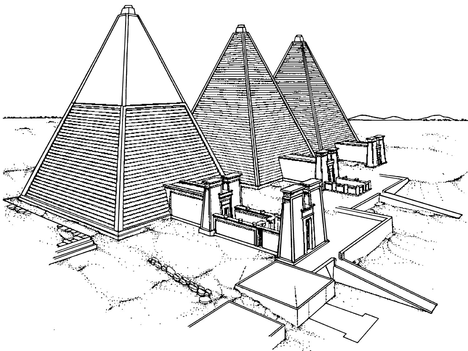
Figure 10.8 Reconstruction of several Meroe pyramids.
Source: Drawing by Friedrich W. Hinkel. K. A. Bard (ed.), The Encyclopedia of the Archaeology of Ancient Egypt. London: Routledge, 1999, p. 509.
Hinkel distinguished 14 different types of pyramids in the three royal cemeteries at Meroe, according to structure, shape, and decoration. The chapels were decorated with mortuary reliefs: the earliest ones have scenes of the king seated on a lion throne behind which is the goddess Isis. Later, members of the royal family are added, along with rows of courtiers and mourners, and scenes from the Book of the Dead. Even later scenes include the (Egyptian) deities Anubis and Nephthys pouring libations of milk onto an offering table with bread, and the dead king giving an offering to Osiris, behind whom is Isis.
Although much more is known about the temples and cemeteries at Meroe than its domestic quarters, 3 kilometers upstream from Meroe at Domat el-Hamadab, where the Wadi el-Hawad enters the Nile Valley, a Meroitic Period town has been excavated by a German-Sudanese expedition beginning in 2001 (Figure 10.9). About 5 hectares in area, the densely inhabited walled town contained blocks of houses to the north and south of a wide street, which led to a small temple on the east side. The temple had been excavated in 1914 by Garstang, who found two monumental stelae there, of Queen Amanirenas and Prince Akinidad. To the south of the temple the recent excavations have identified a large square building, similar in plan to a Meroitic “palace,” which may have been administrative in function. Probable grain storerooms were located along the northern wall of the town. Less dense habitation was also situated outside the town’s southern wall with evidence of industrial areas to the east and south, for iron smelting and the production of ceramic, faïence and glass artifacts. A cemetery was located ca. 500 meters to the south of the extra-mural deposits.

Figure 10.9 Plan of the Meroitic town at Domat el-Hamadab.
Source: Pawel Wolf and Ulrike Nowotnick, “Hamadab, une zone urbaine méroïtique,” Dossier d’Archéologie hors série no. 18: Méroé, un empire sur le Nil aux confins de multiples cultures (March 2010), p. 27.
Royal burials ceased at Meroe by ca. 360. Although the city continued to be occupied until ca. 400, the state and its kingship had already collapsed. If the origins of this kingdom can be pushed back to the 10th/9th centuries BC, then the Napatan-Meroitic state was a very long-lived kingdom. Although Egyptian cults in Roman Egypt continued to be important, Egypt was no longer ruled by a pharaoh who resided there. But at Meroe pharaonic traditions of kingship and royal mortuary practices continued (somewhat transformed with adapted Kushite elements), as did some pharaonic cults and beliefs – and the state never came under Roman domination.
After the collapse of the Meroitic state, Nubia was controlled by smaller polities, and large tumuli of post-Meroitic rulers have been excavated at several sites along the Middle Nile. These polities remained pagan and continued to worship ancient Egyptian (and Nubian) gods. But as Christianity descended across Egypt, it was only a matter of time before missionaries were sent to Nubia (later 6th century), with Christian kingdoms eventually forming there.