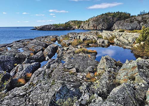
rocky shores in Pukaskwa National Park
S LAKE SUPERIOR PROVINCIAL PARK
TERRACE BAY AND THE SLATE ISLANDS
S SLEEPING GIANT PROVINCIAL PARK
S OUIMET CANYON PROVINCIAL PARK
KAKABEKA FALLS PROVINCIAL PARK
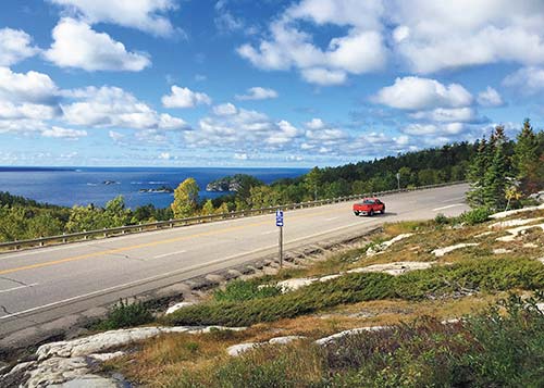
road-tripping through Lake Superior Provincial Park.
Biggest, deepest, longest—Northern Ontario is a place of geographical superlatives, and the region encompassing Lake Superior is no exception. Not only is Superior the deepest of the five Great Lakes, it is the largest body of fresh water in the world. No wonder it’s frequently called an inland sea. Unless you taste the salt-free water as you listen to the waves crashing on the shores of this immense lake, which stretches 560 kilometers (350 miles) from end to end and 260 kilometers (160 miles) across, you’d swear you were looking out across the ocean.
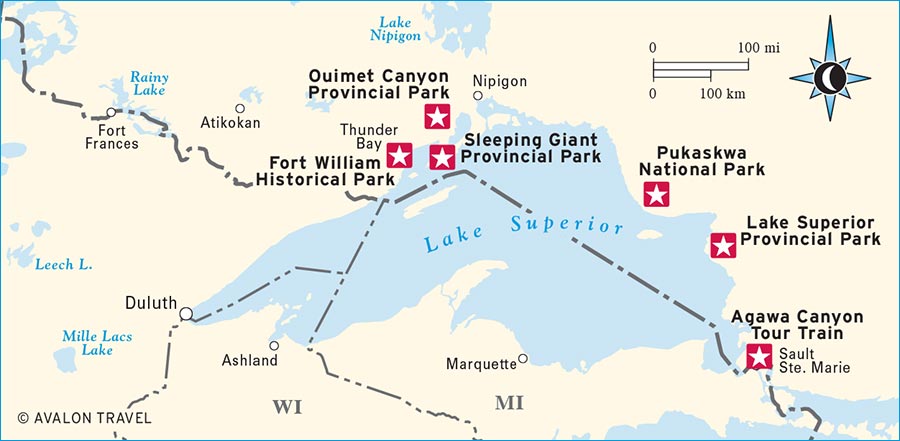
Lake Superior’s land borders include not just Ontario, but the U.S. states of Minnesota, Wisconsin, and Michigan, and a popular driving route circles the lake on both sides of the international boundary. On the Ontario shores, connected by the Trans-Canada Highway, two cities bookend the Lake Superior region: Sault Ste. Marie to the east and Thunder Bay in the west. While each has several worthwhile attractions and a diverse cultural heritage stretching from the aboriginal peoples to more recent immigrant Italians, Scandinavians, and Asians, it’s the landscape and outdoor activities outside the metropolitan areas—on land and on the water—that make Lake Superior special.
From Sault Ste. Marie, you can take a one-day rail journey into the wilderness of Agawa Canyon. North and west of the Sault, the shores of Lake Superior are lined with spectacular beaches, canoe or kayak routes, and rocky cliffs crisscrossed with hiking trails, many in beautiful provincial parks and in Ontario’s largest national park. From Thunder Bay, you can make day trips into nearby parks to wander amid waterfalls, canyons, and dramatic foliage, especially when the autumn leaves turn red and gold.
Lake Superior figures prominently in art and literature, from paintings by Canada’s Group of Seven to the 19th-century epic poem, The Song of Hiawatha, that Henry Wadsworth Longfellow set “By the shores of Gitche Gumee” (from the lake’s Ojibwa name, Gichigami). Whether on foot, with a paddle, or behind the wheel, or with your own camera, paintbrush, or sketchpad, you too can explore the rock-lined shores and wooded landscapes around Longfellow’s “shining Big-Sea-Water.”
Look for S to find recommended sights, activities, dining, and lodging.
S Agawa Canyon Tour Train: A car-free day trip into the northern wilderness, this rail journey is particularly spectacular during the fall foliage season (click here).
S Lake Superior Provincial Park: One of Ontario’s most beautiful outdoor destinations, this provincial park extends along the eastern shore of the world’s largest body of fresh water. You’ll find sandy beaches, rocky coves, rugged hiking trails, and even ancient rock paintings (click here).
S Pukaskwa National Park: Explore First Nations culture at Ontario’s largest national park, where you can also hike and paddle amid stunning Lake Superior terrain (click here).
S Fort William Historical Park: Journey back to the time of the voyageurs and their indigenous trading partners at this re-created early-1800s fur-trading post near Thunder Bay (click here).
S Sleeping Giant Provincial Park: Jutting into the lake across the harbor from Thunder Bay, this craggy, forested park has more than 100 kilometers (60 miles) of hiking trails, including the challenging “Top of the Giant,” which rewards hikers with expansive cliff-top vistas (click here).
S Ouimet Canyon Provincial Park: Carved by natural forces over millions of years, Ouimet Canyon spans a 150-meter (495-foot) gorge with jagged cliffs on either side and lookout points high above the canyon floor (click here).
Distances between northern destinations are long, and it’s a full day’s drive from Toronto to even the nearest points in the Lake Superior region. If your time is limited, consider flying to Thunder Bay or Sault Ste. Marie. Once you’ve arrived near Lake Superior, you can explore either Sault Ste. Marie or Thunder Bay and the nearby parks in a long weekend. Allow at least four or five days to take in the sights along Lake Superior’s North Shore and at least 7-10 days if you’d like to do the full Lake Superior Circle Route, encompassing both the Canadian and U.S. sides of the lake.
July and August are the most popular months for travel in the Lake Superior region, when everything is open and the weather is mild. Consider visiting in autumn (Sept.-mid-Oct.) when the foliage is at its peak and the bugs are (mostly) gone. Avoid May and June, when blackflies and mosquitoes are most active. And if you do travel in the frequently snowy months from November to April, note that many lodgings and restaurants outside the cities shut down except for those catering to snowshoers, snowmobilers, or other outdoor adventurers.
With an Ojibwa community here for centuries, and a French Jesuit mission established in 1668, Sault Ste. Marie, on the St. Mary’s River opposite the U.S. city of the same name, is one of North America’s oldest European settlements. Its riverside location helped it become an important fur-trading post in the 1700s and eventually an industrial city of 75,000 people. While “the Sault” (pronounced “soo”) has several interesting museums, the best attractions take you out of town, including a train tour to Agawa Canyon, a drive north along the shores of Lake Superior, or a day trip east to St. Joseph Island.
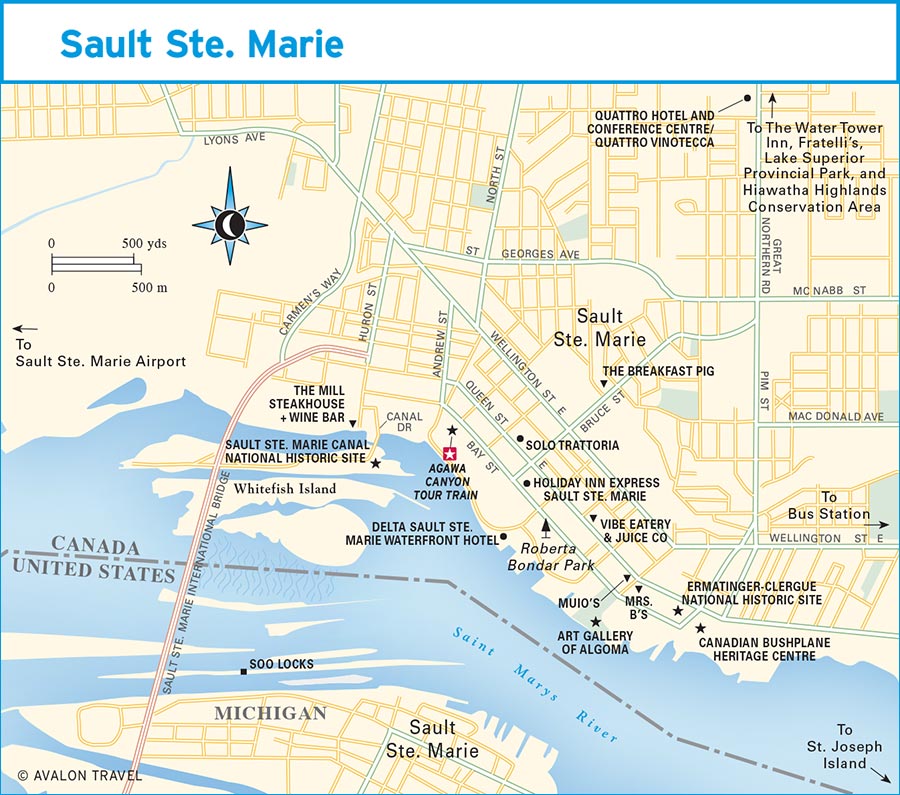
Most of the Sault’s urban attractions are downtown between Queen Street East and the river. Stroll the riverfront boardwalk and stop in Roberta Bondar Park, which honors Canada’s first woman astronaut, a Sault native who flew aboard the space shuttle Discovery in 1992. The park pavilion hosts frequent summer concerts.
In 1895, the Sault Canal opened on the St. Mary’s River, the last link in a system of Canadian waterways connecting Lake Superior to the Atlantic Ocean. At the time, it was the world’s longest lock and the first in Canada to operate on electric power. Although the original lock was replaced in the 1990s, recreational boaters now pass through a smaller lock within the historic one. At the Sault Ste. Marie Canal National Historic Site (1 Canal Dr., 705/941-6262, www.pc.gc.ca, 10am-5pm Mon.-Fri. mid-May-June, 10am-5pm daily July-early Sept., 10am-4pm Mon.-Fri. early Sept.-mid-Oct., free), you can explore exhibits about the region’s shipping history and watch boats travel through the lock. Tours of the site ($5.80 pp), which includes several historic structures, are available on request.
Follow the walkway over the lock for a short hike through the grasses and marshes on South St. Mary’s Island and Whitefish Island, which is part of the traditional territory of the Batchewana First Nation. The three kilometers (1.9 miles) of easy trails lead to several riverside lookouts, with views of the river’s St. Mary’s Rapids and of the International Bridge to the United States. It’s a good location for bird-watching, and you’ll likely spot a beaver dam or two.
Two unusual historic buildings and a modern heritage center constitute the Ermatinger-Clergue National Historic Site (800 Bay St., 705/759-5443, www.ecnhs.com, 9:30am-4:30pm daily late May-mid-Oct., 9:30am-4:30pm Tues.-Sat. mid-Oct-late May, adults $12, seniors and ages 6 and older, $10). In the Heritage Discovery Centre, a worthwhile 20-minute film illustrates the Sault’s history, first as a fur-trading outpost and later as an industrial community, bringing to life the stories of the two businessmen whose residences now sit on the site. The stately, Georgian-style Old Stone House, built in 1814, was home to wealthy fur trader Charles Oakes Ermatinger, his Ojibwa wife, Mananowe (Charlotte), and their 13 children. Next door is the Clergue Blockhouse, a replica of a frontier fort cantilevered above a former gunpowder magazine. Francis Hector Clergue, an industrialist and (ultimately failed) entrepreneur, had this odd structure built in 1895 as his home and office. Costumed interpreters guide you through both buildings and detail 19th-century local life.
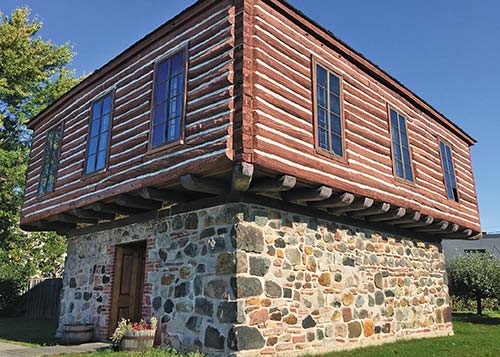
the Clergue Blockhouse at the Ermatinger-Clergue National Historic Site
Small, rugged aircraft known as bush planes traditionally provided a vital transportation link throughout Northern Ontario, offering access to regions with few roads. At the Canadian Bushplane Heritage Centre (50 Pim St., 705/945-6242 or 877/287-4752, www.bushplane.com, 9am-6pm daily mid-May-mid-Oct., 10am-4pm daily mid-Oct.-mid-May; adults $12, seniors $11, students $7, children $3), in a cavernous former air service hangar, you can learn about the importance of these planes past and present and have some fun, too. Climb aboard several of the 25 historic airplanes, check out exhibits on fighting forest fires, or take a video flight tour of Agawa Canyon.
The waterfront Art Gallery of Algoma (10 East St., 705/949-9067, www.artgalleryofalgoma.ca, 9am-5pm Tues.-Sat., adults $7, students $5) has three galleries with rotating contemporary art exhibits that showcase established and emerging regional artists. Among the permanent collection are works by Group of Seven artists and aboriginal artists such as Norval Morrisseau. The gallery shop sells jewelry, cards, and other pieces, many by Northern Ontario artists.
In 1918, artists Lawren Harris, J. E. H. MacDonald, and Frank Johnston rented a boxcar in which to travel and paint along the Algoma Central Railway, which runs north from Sault Ste. Marie into Agawa Canyon and beyond. These painters, along with several colleagues who later joined them, became known as the Group of Seven, creating and exhibiting the works that these wilderness sojourns inspired.
You don’t have to travel by boxcar to explore the same scenery that motivated these artists. Book a seat on the Agawa Canyon Train (Algoma Central Railway, 129 Bay St., 705/946-7300 or 800/242-9287, www.agawatrain.com, daily late June-mid-Oct., summer prices adults $92, seniors $82, ages 2-18 $46, fall prices adults and senior $110, ages 2-18 $76), a one-day trip into the wilderness.
Agawa Canyon is tiny compared to Arizona’s Grand Canyon or Mexico’s Copper Canyon, but with a river winding amid the trees and below the rock walls, it’s an attractive—and car-free—destination. The most popular times for the trip are the last two weeks of September and the first week of October, when fall colors typically peak.
After the train pulls out of Sault station at 8am, beginning the four-hour, 184-kilometer (114-mile) ride north, the city’s mills and factories give way to forests, hills, and lake after lake. At Mile 92, the train crosses a curved trestle bridge over the Montreal River; near Mile 102, look left and you can see all the way to Lake Superior. You can take in the “engineer’s view,” too; cameras mounted on the engine periodically project onto monitors inside the coaches. Recorded commentary tells you about other scenic spots en route.
Passengers disembark at the canyon, where they have about 90 minutes to explore before the return train leaves. The prettiest hike climbs 320 steps up the Lookout Trail (30-40 minutes round-trip), the best vantage point for photos over the canyon. The flatter Bridal Veil Falls Trail (30 minutes round-trip) goes to the 68.5-meter (225-foot) waterfall of the same name. As you walk back from the falls, take the path across the train tracks (carefully) to follow the Black Beaver Falls Trail to a second, smaller waterfall. If you don’t dawdle, you should have time to see both the lookout and the falls.
The train’s dining car begins serving breakfast shortly after the morning departure and is open for lunch until late afternoon. You’re also welcome to bring your own food to eat en route or picnic at the canyon. However, you may prefer to eat on the train and use the relatively brief canyon stopover to explore. The train returns to Sault Ste. Marie around 6pm.
Take a short hike through the forests of maples, white pines, and other trees at Hiawatha Highlands Conservation Area (1100 5th Line E., 705/946-8530, www.ssmrca.ca, 9am-9pm daily, free). In the Kinsman Park section of the conservation area, a pretty walk takes you along a boardwalk and up a staircase to Crystal Falls. Hiawatha Highlands is 12 kilometers (7.5 miles) northeast of downtown.
Northwest of the city, Lake Superior Provincial Park (Hwy. 17, 705/856-2284, www.ontarioparks.com or www.lakesuperiorpark.ca, mid-May-mid-Oct., $14.50 per vehicle) has an extensive network of hiking trails.
Have you always wanted to learn to fish? Try your hand at hooking a big one without even leaving the city by booking a guided fishing excursion on the St. Mary’s River. Several local operators offer half- or full-day fishing packages, both on the river and on the lakes throughout the Algoma region.
Adam Valee is a competitive tournament bass fisher and fishing guide. Through his company Angling Algoma (705/943-5286, www.anglingalgoma.com), he’ll take you out on the river, show you how to cast, and point out where the largemouth bass are hiding. And while he’s a pro, he’s patient with beginners. He can arrange half-day (1-2 people $300, each additional person $75) or full-day (1-2 people $475, each additional person $75) river trips.
Other local fishing guides include Tyler Dunn Guiding (705/206-0984, www.tylerdunnguiding.ca) and John Giuliani’s Fishing Adventures (906/203-9112, www.stmarysrapidsguiding.com). For guidance in booking a fishing adventure, contact Sault Ste. Marie Tourism (705/759-5442 or 800/461-6020, www.saulttourism.com), which works with several of these local companies and periodically offers discounted fishing packages.
Dining options are plentiful around Queen Street East downtown and amid Great Northern Road’s strip malls. The city has a large Italian population, which makes Italian eating a good choice; finding the best pizza is a competitive sport.

Finding the best pizza is a competitive sport in Sault Ste. Marie.
The cheery vibe at Vibe Eatery & Juice Co (112 March St., 705/949-8423, vibeeatery.ca, 8am-6pm Mon.-Wed., 8am-8pm Thurs.-Fri., 9am-6pm Sat., 10am-4pm Sun., $6-15) draws diners to this vegetarian café on a downtown side street for light breakfasts and lunches, from fresh juices, smoothies, and muffins to salads, beet burgers, and falafel wraps.
Calling itself a “badass eatery,” The Breakfast Pig (265 Bruce St., 705/450-6911, www.thebreakfastpig.com, 8am-4pm daily, $10-15) dishes out substantial morning meals featuring local ingredients; all their pork products come from a nearby farm. Among the specialties: “The Angela” (named for the owner), a veggie-filled, balsamic-glazed potato hash with poached eggs on top; waffle poutine, a serving of deep-fried waffles piled with mozzarella, gravy, and pulled pork; and eggs Benedict with locally caught smoked trout.
Popular with everyone from young folks on dates to old folks on pensions, S Muio’s (685 Queen St. E., 705/254-7105, www.muios.com, 7am-close daily, lunch $5-12, dinner $11-24) is so retro, it’s hip. The must-have dish is the “broasted” chicken (the Sault’s version of southern fried chicken), which comes as chicken on a bun or as a heaping platter with potatoes and salad or coleslaw. The ravioli is another favorite, and other options include pizza, burgers, and steaks. Breakfast is served as well.
Looking for classic Italian downtown? Solo Trattoria (250 Queen St. E., 705/254-7656, www.solotrattoria.ca, 11am-10pm Mon.-Sat., lunch $9-15, dinner $14-30) serves up grilled panini and salads midday, pastas, seafood, and steaks in the evenings, and pizza all the time.
Among pizza partisans, popular picks include Mrs. B’s (76 East St., 705/942-9999, www.mrsbspizza.ca, 11am-10pm Mon.-Thurs., 11am-11:30pm Fri.-Sat., noon-7pm Sun., $7-27) in a bright red building downtown, with a second location (97 Great Northern Rd., 705/575-7522) open the same hours, and Fratelli’s (522 Great Northern Rd., 705/256-1313, www.fratellisrestaurant.ca, 11:30am-11pm Mon.-Sat., 11:30am-10pm Sun., $9-29), which also makes tasty panzarotti, Ontario’s version of a calzone.
For a classy evening out, meat lovers head for The Mill Steakhouse + Wine Bar (83 Huron St., 705/942-3051, www.machineshopinc.ca, 11am-10pm Sun.-Thurs., 11am-midnight Fri.-Sat., lunch $10-15, dinner $22-40) near the Sault Canal. It’s set in a former machine shop built in the late 1890s and retains its exposed brick walls, ceiling pipes, and other industrial features. The evening menu leans heavily toward classic steaks paired with potatoes and vegetables. At lunch, choose from burgers, steak sandwiches, and salads.
The city’s most upscale lodging is the riverfront Delta Sault Ste. Marie Waterfront Hotel (208 St. Mary’s River Dr., 705/949-0611 or 888/236-2427, www.marriott.com, $128-260 d), where many of the 195 contemporary rooms, with mini fridges, flat-screen TVs, and free Wi-Fi, have water views. The fitness center, indoor pool, and restaurant overlook the river.
If you have a car, an excellent-value lodging for both families and business travelers is The Water Tower Inn (360 Great Northern Rd., 705/949-8111 or 888/461-7077, www.watertowerinn.com, $115-155 d). Although the surroundings are typically suburban, once you’re inside, it feels like a mini resort, particularly in the Aqua Spa, with its indoor pool and indoor-outdoor hot tubs.
Another good choice if you have your own transportation is the Quattro Hotel and Conference Centre (229 Great Northern Rd., 705/942-2500, www.quattrossm.com, $119-169 d). Decorated with dark woods, white linens, and purple accents, the 157 rooms are all suites, with sitting areas, fridges, and microwaves. For exercise, head for the indoor pool or large fitness room. Rates include a buffet breakfast in Quattro Vinotecca (11:30am-2pm and 5pm-11pm Mon.-Fri., 5pm-11pm Sat., 5pm-10pm Sun., lunch $10-22, dinner $23-48), which is also a good option for Italian-influenced meals of spinach and mushroom ravioli, grilled branzino, or filet mignon.
Among the midrange chain hotels downtown, the renovated 115-room Holiday Inn Express Sault Ste. Marie (320 Bay St., 705/759-8200, www.ihg.com/holidayinnexpress, $121-214 d) is a short walk from the Agawa Canyon train station and the waterfront.
The helpful crew at Tourism Sault Ste. Marie (99 Foster Dr., 705/759-5442 or 800/461-6020, www.saulttourism.com), and their equally informative website, can clue you into things to do in the Sault. For more information about the region surrounding Sault Ste. Marie, contact the Algoma Kinniwabi Travel Association (334 Bay St., 705/254-4293 or 800/263-2546, www.algomacountry.com).
The Ontario Sault is across the river from its Michigan namesake. Michigan’s I-75 crosses the International Bridge into the Canadian Sault’s downtown. Remember that passports are required for travel between the United States and Canada. Within Ontario, it’s an easy 3.5-hour drive between Sault Ste. Marie and Sudbury, 300 kilometers (186 miles) to the east. The Sault is roughly equidistant (700 kilometers, or 435 miles) to Toronto and Thunder Bay.
From Sault Ste. Marie Airport (YAM, 475 Airport Rd., 705/779-3031, www.saultairport.com), 20 kilometers (12 miles) west of downtown, Air Canada (www.aircanada.com) and Porter Airlines (www.flyporter.com) fly to Toronto. Bearskin Airlines (www.bearskinairlines.com) has flights to Thunder Bay.
The Greyhound Bus Station (Howard Johnson’s, 503 Trunk Rd., 705/541-9305 or 800/661-8747, www.greyhound.ca), northeast of downtown, has buses to Sudbury (4.5 hours, $35-86), Toronto (10.5 hours, $72-138), and Thunder Bay (9.75 hours, $72-181), among other destinations. At the same location, Ontario Northland (800/461-8558, www.ontarionorthland.ca) buses arrive from North Bay (6.5 hours, $94) and Sudbury (4.5 hours, $68), daily except Saturday.
The city’s attractions cluster in the walkable downtown. The 25-kilometer (15-mile) John Rowswell Hub Trail, for pedestrians and cyclists, loops through the city center connecting all the main sights. However, to explore Lake Superior Provincial Park or other day-trip sights, you’ll need your own wheels. All the major car rental companies have offices in Sault Ste. Marie.
Batchawana Bay Provincial Park (Hwy. 17, 705/882-2209, www.ontarioparks.com, mid-May-mid-Oct., $11.25 per vehicle), on Lake Superior 70 kilometers (44 miles) north of the Sault, has a long sandy beach that’s a pleasant place to swim or lounge by the lake. Fun fact: Batchawana Bay is the approximate east-west midpoint of the Trans-Canada Highway, the world’s longest national highway.
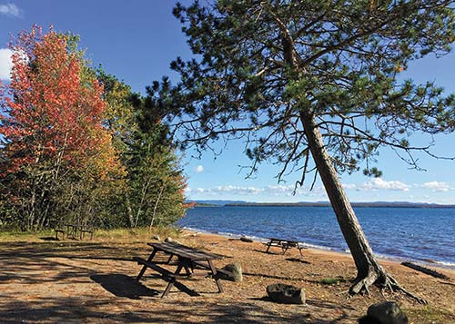
Batchawana Bay Provincial Park
Even lovelier is the smooth stretch of sand backed by dunes and trees at Pancake Bay Provincial Park (Hwy. 17, 705/882-2209, www.ontarioparks.com, early May-mid-Oct., $14.50 per vehicle), 10 kilometers (6.2 miles) farther north. Hikers may want to follow the Edmund Fitzgerald Lookout Trail (Lookout Trail Rd.) to a viewing platform above the section of the lake where the SS Edmund Fitzgerald sank in 1975; allow two to three hours to hike the seven-kilometer (4.4-mile) trail. The trailhead is across the highway from the rest of the park, two kilometers (1.2 miles) to the north.
A popular place for camping (tent sites $42-45, electrical sites $47-52), Pancake Bay has 328 campsites along the water; try to book a lakefront site or one up in the Hilltop Campground, as others are quite close to the highway. The campground has showers, flush toilets, and laundry facilities, as well as five yurts ($98) that each sleep six. Reserve campsites and yurts through the Ontario Parks Reservations Service (888/668-7275, www.ontarioparks.com, reservation fee online $11, by phone $13).
For a big bite to eat in Batchawana Bay, try the hearty fare at Voyageurs’ Lodge and Cookhouse (Hwy. 17, 705/882-2504, www.voyageurslodge.com), including burgers, tourtière (Quebec meat pie), and traditional baked beans with bannock. They’re especially busy Friday evenings for their weekly fish fry. If you can’t bear to get back on the road after stuffing yourself on the blueberry crisp, check into one of the motel rooms. The Voyageurs’ store sells essentials, booze, and delicious, supersized apple fritters.
TOP EXPERIENCE
One of Ontario’s most beautiful outdoor destinations, Lake Superior Provincial Park (Hwy. 17, 705/856-2284, www.ontarioparks.com or www.lakesuperiorpark.ca, mid-May-mid-Oct., $14.50 per vehicle) stretches 115 kilometers (72 miles) along Lake Superior’s eastern shore. As you sit on a sandy beach or scramble up the rocky cliffs, you could be forgiven for thinking you were actually at the ocean, as surf crashes onto the rocks and the steely blue-gray water disappears into the horizon, with no land in sight.
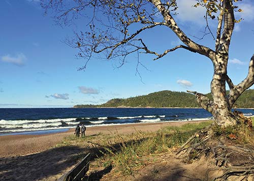
on the beach in Lake Superior Provincial Park
For park information, contact the main park office, located in the northern half of the park near Red Rock Lake, or the Agawa Bay Visitors Centre (705/882-2026, 9am-8pm daily mid-June-early Sept., 9am-5pm daily mid-May-mid-June and early Sept.-mid-Oct.). If you’re coming from the north, pick up a park brochure and map at the Wawa Tourist Information Centre (Hwy. 17 at Hwy. 101, Wawa).
The Lake Superior region famously inspired the Group of Seven landscape painters in the early 1900s. Find your own inspiration with the Art in the Park programs, which might include painting or printmaking workshops. Throughout the summer, park staff offer guided hikes, kids’ programs, evening presentations, and other activities. Get program details from the Visitors Centre or the website of the Friends of Lake Superior Park (www.lakesuperiorpark.ca).
At the park’s south end, stop at the well-designed and modern Agawa Bay Visitors Centre (705/882-2026, 9am-8pm daily mid-June-early Sept., 9am-5pm daily mid-May-mid-June and early Sept.-mid-Oct.) to learn more about Lake Superior, which is not just the largest, deepest, and coldest of the Great Lakes—it’s the largest body of freshwater in the world. Other exhibits illustrate the lake’s legendary storms, including the one that sank the freighter SS Edmund Fitzgerald in 1975, immortalized in Ontario-born singer Gordon Lightfoot’s ballad “Wreck of the Edmund Fitzgerald.” The knowledgeable staff here can help you plan your time in the park. Wi-Fi is available by donation.
A few kilometers north of Agawa Bay, a short (0.5-kilometer, 0.3-mile) but steep and rocky trail leads to the Agawa Rock Pictographs (late-May-mid-Sept.), red ocher graphics that Ojibwa people painted on a lakefront rock face several hundred years ago. It’s still an active sacred site; park staff are usually on hand in July and August to help interpret its significance to the indigenous people. The rocky shore here is especially beautiful. Because you have to venture out onto slippery rocks to see the pictographs, you can visit only when the lake is calm; otherwise, the surf can crash dangerously onto the rocks.
Continuing north is Katherine Cove, with a sheltered beach of fine white sand that is a pretty picnic spot. If the surrounding trees were palms instead of evergreens, you could imagine that you were in the Caribbean. The terrain changes again at Old Woman Bay, approaching the park’s northern boundary. Evergreen hills rise and fall around the bay, and waves often pound the broad, sandy beach.
Hikers will find a wide variety of terrain on the park’s 11 trails, ranging from easy paths like the two-kilometer (1.2-mile) Crescent Lake Trail, the longer six-kilometer (3.7-mile) but still fairly flat Pinguisibi-Sand River Trail, or the rugged 65-kilometer (40-mile) Coastal Trail that extends from Agawa Bay north beyond Gargantua Harbour; allow five to seven days to hike the entire coastal route, though you can do sections as day hikes. Pick up hiking information and maps at the park office or the Agawa Bay Visitors Centre.
You can swim in Lake Superior if you’re hardy; the surf is often strong, and even in August the average surface temperature is a chilly 14.5°C (58°F). Head for one of the more sheltered bays to find warmer water. The park has several interior lakes, which are warmer, calmer places to swim or boat. You can rent canoes (mid-June-early Sept., $10 per hour, $30 per day) at Agawa Bay and Rabbit Blanket Lake, and from the Red Rock Park Office near Mijinemungshing Lake.
The park has 206 campsites in three different areas. To camp beside Lake Superior, book a site at the park’s largest and most popular camping area, Agawa Bay Campground (mid-May-mid.-Oct., tent sites $42-45, electrical sites $47-52), where the premium sites are right on the beach. Agawa has showers, flush toilets, laundry facilities, and an outdoor amphitheater offering summer nature programs. In the park’s northern half, on a smaller interior lake, Rabbit Blanket Lake Campground (mid-May-mid-Oct., tent sites $42, electrical sites $47) has flush toilets, showers, and a laundry. To reserve campsites at Agawa Bay and Rabbit Blanket Lake, contact the Ontario Parks Reservations Service (888/668-7275, www.ontarioparks.com, reservation fee online $11, by phone $13).
The park’s 200 backcountry campsites (mid-May-Oct., adults $11, ages 6-17 $5) are accessible on foot or by canoe.
If you don’t want to camp, the closest accommodations are south of the park in Batchawana Bay or Montreal River Harbour with more options to the north in Wawa. You can also stay in Sault Ste. Marie and spend the day in the park.
Naturally Superior Adventures (705/856-2939 or 800/203-9092, www.naturallysuperior.com) is based at the Rock Island Lodge, near Wawa. Rent kayaks, take kayaking lessons, or sign up for day hikes or canoe or kayak excursions. In July and August, they arrange stand-up paddleboarding sessions at Rabbit Blanket Lake. They can also organize multiday adventure trips in the park and around the Lake Superior region.
Headquartered south of the park in Goulais River, Caribou Expeditions (705/649-3540 or 800/970-6662, www.caribou-expeditions.com) focuses on water-based adventures, including kayak or canoe rentals and guided tours, lodge-to-lodge kayaking trips, and wilderness excursions.
Highway 17 from Sault Ste. Marie to Wawa bisects Lake Superior Provincial Park; you can tour the park on a day trip from either town. From the Sault, it’s 140 kilometers (87 miles)—less than two hours by car—to the Agawa Bay Visitors Centre, and another 64 kilometers (40 miles) from Agawa Bay to Old Woman Bay.
There’s no food, gas, or other services within the park, so check your fuel in Sault Ste. Marie or Wawa and bring whatever supplies you need.
Wawa is derived from an Ojibwa word meaning “wild goose,” so it’s fitting that the chief landmark in this community is the 8.5-meter-tall (28-foot-tall) Wawa Goose. The current goose perches south of town outside the Wawa Tourist Information Centre (Hwy. 17 at Hwy. 101, www.experiencewawa.ca, 8am-8pm daily July-Aug., 9am-5pm daily mid-May-June and Sept.-mid-Oct.). Installed in 2017 to replace its decaying predecessor, it’s an exact replica of the goose statue that sculptor Dick Vandercliff crafted in the 1960s. After taking your obligatory goose photo, head inside to pick up information about the Lake Superior region or check your email (there’s free Wi-Fi).
While most travelers use Wawa as a base for exploring Lake Superior Provincial Park or as a stopover between Sault Ste. Marie and Thunder Bay, you can stretch your legs at a couple of other outdoor stops. With an interpretive display about the local First Nations, the large Sandy Beach fronts Lake Superior south of town; take Michipicoten River Village Road west off Highway 17 and follow the beach signs. In town, there’s an attractive beach on Wawa Lake.
At the intersection of Highways 17 and 101, Wawa is 230 kilometers (145 miles) north of Sault Ste. Marie and 475 kilometers (295 miles) east of Thunder Bay.
The best place to stay near Wawa is S Rock Island Lodge (10 Government Dock Rd., 705/856-2939 or 800/203-9092, www.rockislandlodge.ca, mid-May-mid-Oct., $118-138 d). The four rooms don’t have phones or TVs, but they do have private baths, Wi-Fi, and awe-inspiring views of Lake Superior. Out on the deck, the lake is so close that you’re practically in the water. Rates include breakfast; staff will prepare lunch and dinner on request, or you can use the lodge kitchen to cook your own meals. You can also “glamp” in their “Geo Dome” ($60 d without breakfast, $75 d with breakfast), a yurt-like tent with a wood floor, queen bed (linens are provided), and a nearby composting toilet. The on-site outfitter, Naturally Superior Adventures (705/856-2939 or 800/203-9092, www.naturallysuperior.com), rents kayaks, leads day hikes, and offers canoe and kayak excursions.
Five kilometers (three miles) south of the Wawa visitors center, Best Northern Motel (150 Hwy. 17, 705/856-7302 or 800/434-8240, www.bestnorthern.ca, mid-Apr.-mid-Dec., $99-105 d, $135 cottages) is an updated roadside lodging with 11 guest rooms, all with microwaves, refrigerators, coffeemakers, and flat-screen TVs, as well as three two-bedroom cottages. The main lodge has a sauna, a rec room with a pool table, and a restaurant (7:30am-10am and 5pm-9pm daily, dinner $12-30) that’s worth a visit for its Polish specialties, including excellent pierogi and cabbage rolls. For dessert, if there’s no homemade pie, consider the cheese-filled crepes with berry sauce.
Surprise—you can travel to the Caribbean at friendly S Kinniwabi Pines International Restaurant (106 Hwy. 17, 705/856-7226, 8am-9pm daily, lunch $8-13, dinner $16-25), with tables overlooking the river. The owners hail from Trinidad, so don’t miss the top-notch chicken, potato, and chickpea curry, served with roti. The spicy baked pork chop is another popular choice from the world-roaming menu that also spans Chinese and Canadian dishes. For breakfast, try Trinidadian-style scrambled eggs with tomatoes or salt cod with fry bread.
Next to a car dealership, in an unassuming motel block eight kilometers (five miles) west of town, longtime owners Maureen Hutchinson-Parker and John Parker have outfitted their homey guest rooms at the Northern Lights Motel (1014 Hwy. 17, no phone, http://nlmotel.com, mid-May-mid-Oct., $99-119 d) with plenty of personality, from trivia quizzes taped to the bathroom door to humorous illustrated notes outlining everything you need to know about the property. Four rooms have two queen beds with blue and white quilts; another room has two doubles; and there’s a two-bedroom cottage ($144-174) and a three-bedroom chalet ($225-255). While you have to head into town to dine out, rooms come with microwaves, fridges, coffeemakers, and a book of local restaurant menus.
You’ll find more basic motels and eateries in town, along Mission Road and Broadway Avenue, Wawa’s main streets. The 21 cozy rooms at the two-story Beaver Motel (148 Mission Rd., 705/856-2294 or 866-819-4286, www.beavermotel.com) are more modern than the exterior suggests, with updated furnishings, contemporary baths, and in-room fridges. You can grab a free cup of morning coffee in the lobby. The Wawa Motor Inn (118 Mission Rd., 705/856-2278 or 800/561-2278, www.wawamotorinn.ca, $91-169 d) has adequate rooms in its main motel block and in a rustic “log village” set back from the road, plus several two-bedroom cottages ($225-325).
The Trans-Canada Highway runs along Lake Superior’s northern shore, lined with boreal forests and rocky evidence of the Canadian Shield. The road dips and rises, gently curving toward or away from the lake, with wow-inducing landscapes and water vistas surprising you as you round a bend or crest a hill. One of Ontario’s most beautiful driving routes, this section of the Trans-Canada connects Wawa to the city of Thunder Bay and beyond, with stopover towns and both national and provincial parks along the way.
A 10,000-square-kilometer (3,900-square-mile) section of Lake Superior forms the Lake Superior National Marine Conservation Area (807/887-5467, www.pc.gc.ca), the marine equivalent of a Canadian national park. Beginning east of Terrace Bay, the conservation area encompasses a third of the lake’s Canadian waters and approximately 600 islands west to the Sibley Peninsula (home of Sleeping Giant Provincial Park) and south to the U.S. border. When its establishment is finalized, it will become the largest protected freshwater area in the world.
While the conservation area doesn’t have a visitors center or official facilities, Parks Canada staff work with local communities and First Nations to develop programs for visitors, host special events, and promote the region’s numerous land- and water-based recreational activities, such as hiking, wildlife viewing, cross-country skiing, canoeing, kayaking, sailing, fishing, scuba diving, and even surfing on the lake. Outfitters in Wawa, Terrace Bay, Rossport, Nipigon, and Red Rock organize all manner of outdoor trips, and the Parks Canada website has details about local hiking trails and other recreational opportunities.
You can make the 485-kilometer (300-mile) drive from Wawa to Thunder Bay in a leisurely day, but plan to make stops along the way. You could spend weeks here before you’d run out of outdoor adventures. Except in the cities of Sault Ste. Marie and Thunder Bay, the Lake Superior region has little in the way of public transportation. While Greyhound (www.greyhound.ca) does provide bus service to towns along Lake Superior’s North Shore, it’s not practical to explore without a car unless you’ve arranged with an outfitter for local transportation.
TOP EXPERIENCE
The largest national park in Ontario spreads across Lake Superior’s northeastern reaches, encompassing 1,878 square kilometers (725 square miles) of northern forest and Great Lake coastline that are home to moose, woodland caribou, wolves, and bears. Pronounced “PUCK-a-saw,” Pukaskwa National Park (off Hwy. 627, Heron Bay, 807/229-0801, www.pc.gc.ca, late May-mid-Oct., adults $5.80, seniors $4.90) draws both novice outdoorspeople and experienced adventurers who come to hike or kayak amid Lake Superior’s dramatic terrain. The park also offers interesting programs to introduce visitors to the region’s First Nations culture.
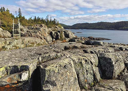
hiking along the rocks in Pukaskwa National Park
In summer, the waterside Hattie Cove Visitors Centre (9am-4pm Sun.-Thurs., 9am-8pm Fri.-Sat. July-Aug.) is a hub of activity, with daily interpretive programs ranging from art workshops to guided hikes to presentations about the park’s prescribed fire program for maintaining the health of its forests. Check out the colorful wall mural full of First Nations symbols. The center has free Wi-Fi.
Park cultural interpreters run unique programs at the Anishinaabe Camp, which has several traditional First Nations wigwams and other structures near the Visitors Centre. Staff demonstrate and interpret aspects of Ojibwa culture, including traditional medicines, drumming, and ceremonies, sharing not just aboriginal heritage but present-day life and teachings of the First Nations communities who make their home in this region. Get a program schedule from the Visitors Centre.
Pukaskwa has lots of choices for day hikes of varying levels of difficulty:
• Beach Trail (1.5 km, easy): Follows the boardwalk along the Lake Superior shore.
• Manitou Miikana (2 km, moderate): Known as the “Spirit Trail,” this route wends through the woods to two lookouts high above the lake.
• Southern Headland Trail (2.2 km, moderate): Top-notch lake views can be had as you wander through the pine forests and along the rocky shores.
• Bimose Kinoomagewnan (2.6 km, moderate): An interpretive trail around Halfway Lake, highlighting the Ojibwa people’s Seven Grandfather Teachings. Park cultural interpreters lead periodic guided hikes on this trail; check with the park office for schedules.
• White River Suspension Bridge (18 km round-trip, moderate): This demanding but popular full-day hike leads to a suspension bridge 23 meters (75 feet) above Chigaminqinigum Falls.
For experienced backcountry hikers who want a multiday adventure, the park’s Coastal Hiking Trail runs 60 kilometers (37 miles) one-way through rugged wilderness terrain. Refer to the Coastal Hiking Trail Trip Planner, available on the park website (www.pc.gc.ca), for more details about backcountry hiking.
Pukaskwa’s offshore waters aren’t a beginner kayaking or canoeing destination, as Lake Superior’s weather and water conditions can be changeable and challenging. Unless you’re an experienced kayak tripper, consider working with a local outfitter to plan your paddling adventure. Naturally Superior Adventures (705/856-2939 or 800/203-9092, www.naturallysuperior.com) offers guided sea kayaking trips along the Pukaskwa coast. The park publishes a detailed Coastal Paddling Route Trip Planner, available online, to help you prepare for a paddling journey.
Hattie Cove Campground (late May-early Sept. tent sites $25.50, electrical sites $29.40, May and Sept.-mid-Oct. tent sites $15.70, electrical sites $19.60) has 67 well-spaced wooded sites. The 29 electrical sites are all in the larger south loop area; tent campers may prefer the quieter north loop. Both areas have comfort stations with hot showers and flush toilets. The park does not accept advance reservations for Hattie Cove sites. In spring and fall, some campground facilities, including restrooms, are closed; campsite fees are reduced accordingly.
If you don’t have your own tent, book one of the park’s five oTENTiks ($100-120), platform tents sleeping up to six, near the Hattie Cove Visitor Centre. The cabin-like shelters come with one queen and two double sleeping platforms, a table and chairs, grill, and a food locker; bring your own bedding, food, and cooking equipment. Reserve oTENTiks in advance (877/737-3783, http://reservation.pc.gc.ca).
Backpackers traveling the Coastal Hiking Trail can set up camp at primitive backcountry sites along the route, which are equipped with a tent pad, privy, fire pit, and bear box. You must book backcountry sites in advance; reserve online or by phone (807/229-0801 or 877/737-3783, http://reservation.pc.gc.ca).
Pukaskwa National Park is approximately 410 kilometers (255 miles) northwest of Sault Ste. Marie and 310 kilometers (195 miles) east of Thunder Bay. It’s located off Highway 17, the Trans-Canada Highway, 180 kilometers (115 miles) west of Wawa, about a two-hour drive. Take the Heron Bay exit onto Highway 627 and follow it 15 kilometers (nine miles) to the park entrance.
You can pick up basics at convenience stores in Biigtigong Nishnaabeg, the indigenous community formerly known as the Pic River First Nation (www.picriver.com), bordering the park on Highway 627. The nearest town with lodging, restaurants, and other services is Marathon (www.marathon.ca), eight kilometers (five miles) west of the Highway 627 turnoff. Terrace Bay, 98 kilometers (60 miles) west of the park, has additional lodging options.
Overlooking Lake Superior, the town of Terrace Bay (population 1,800) grew from the surrounding woods; for decades, its main employer has been a pulp mill. It’s now a jumping-off point for exploring the Lake Superior National Marine Conservation Area, and it has enough services to make it a handy stop as you’re traveling across the lake’s North Shore.
A collection of rocky islands in Lake Superior, 13 kilometers (eight miles) off the coast of Terrace Bay, the Slate Islands are home to the largest known herd of predator-free woodland caribou. In the early 1900s, during particularly cold winters when Lake Superior froze all the way to the islands, caribou crossed from the mainland, where they have remained and thrived. Beavers, red foxes, snowshoe hares, and other small mammals also live on the islands, which offer lots of adventures for kayakers and hikers.
The Terrace Bay Lighthouse (Simcoe Plaza, off Hwy. 17, Terrace Bay, 8am-10pm Mon.-Fri., 9:30am-9pm Sat.-Sun., free) never guided any ships ashore. The town built this 15-meter (50-foot) tower as a replica of the lighthouse on the nearby Slate Islands; sitting at 68 meters (224 feet) above sea level, the Slate Island Light is considered the tallest lighthouse on the Great Lakes. The replica lighthouse is a lookout tower, with views over the town to the lake.
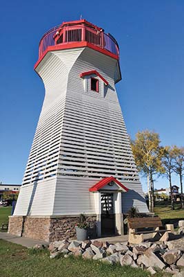
the Terrace Bay Lighthouse
About one kilometer (0.6 miles) west of town, a short walkway leads to a viewing platform above pretty Aguasabon Falls (Hwy. 17, Terrace Bay, www.terracebay.ca). Pronounced “AUG-was-saw-bin,” the falls cascade 30 meters (100 feet) into a deep gorge.
On Lake Superior, wide, sandy Terrace Bay Beach (Beach Ave.) is a five-minute drive south of Highway 17. In the small town of Schreiber, 15 kilometers (nine miles) west of Terrace Bay, Schreiber Beach is a little harder to find, but its secluded shores, lined with pink-tinged stones, are worth seeking out. The beach is three kilometers (1.9 miles) from Schreiber’s town center. From Scotia Street, take the underpass on Subway Street beneath the railroad tracks, then turn right to follow steep Isbester Drive until it ends just above the beach.
Hikers can explore sections of the challenging, 52-kilometer (32-mile) Casque Isles Trail (www.voyageurtrail.ca) that connects Terrace Bay, Schreiber, and Rossport. You can pick up the trail near Terrace Bay Beach or Schreiber Beach.
The two largest Slate Islands, Patterson and Mortimer, along with several smaller islands and their surrounding waters, make up Slate Islands Provincial Park (www.ontarioparks.com), which currently has no visitor facilities. Several outfitters run day trips or overnight trips to the Slates. Departing from Terrace Bay or Rossport, the Bluebird Charter Boat (807/824-3353, www.bluebirdcharterboat.com, $124 per hour for 1-4 people) runs sightseeing tours to the Slates and other Superior islands. Wawa-based Naturally Superior Adventures (705/856-2939 or 800/203-9092, www.naturallysuperior.com) offers guided kayak trips in the Slate Islands.
You can buy snacks and groceries at Costa’s Foods (Simcoe Plaza, Terrace Bay, 807/825-4501, www.costasfoods.ca, 9am-6pm Mon.-Fri., 8:30am-5:30pm Sat.). Also in the plaza are a liquor store, bank, post office, bakery, and Chinese restaurant.
Terrace Bay has several basic roadside motels. The 16-room Norwood Motel (Hwy. 17, Terrace Bay, 807/825-3282, $75 d) looks straight from the 1950s, pink bath tile and all, but the rooms have microwaves, mini fridges, free Wi-Fi, and (surprise!) Keurig coffeemakers.
Although they face a gas station, many rooms at Drifters Imperial Motel (Hwy. 17, Terrace Bay, 807/825-3226 or 877/825-1625, $89-109 d) have been updated with woodsy log furnishings and free Wi-Fi. Adjacent to the motel, friendly Drifters Restaurant (807/825-3226, 6am-10pm daily, lunch $5-13, dinner $12-35) specializes in Italian dishes, like the ample “roadhouse pasta” with chicken, bacon, mushroom, and peppers. It also serves burgers, steaks, and salads, including a meal-size spinach salad with feta cheese and figs or a romaine, cranberry, and chicken plate.
Terrace Bay is on Highway 17, 260 kilometers (160 miles) west of Wawa and 225 kilometers (140 miles) east of Thunder Bay. The Terrace Bay Tourist Information Centre (1008 Hwy. 17, 807/825-3315, ext. 235, or 800/968-8616, www.terracebay.ca, 9am-6pm daily late May-Sept.) provides information about the Lake Superior North Shore and has free Wi-Fi. The town of Terrace Bay offers free Wi-Fi that you can pick up around Simcoe Plaza.
The waterside hamlet of Rossport is another worthwhile stopover along Lake Superior’s North Shore. Watch carefully for the exit, or you’ll easily blow right past the tiny town, which is home to fewer than 100 souls. You can hike, swim, canoe, or kayak in a nearby provincial park, or use the village as a launching point for Slate Islands trips. Unlike many North Shore communities, which have only simple roadside motels, Rossport has several bed-and-breakfasts.
Tiny Rossport Museum (Main St., July-Aug.), housed in a Canadian Pacific Railroad caboose, has exhibits on the area’s rail and marine history.
For a short hike along the Lake Superior shore, follow the 1.5-kilometer (0.9-mile) Rossport Coastal Trail. Some sections are close enough to Highway 17 that you can hear the cars whiz by, but the lake views make up for it. It’s a linear trail, so you need to return the way you came. The trailhead is at the east end of Rossport village.
Eleven kilometers (seven miles) east of Rossport, Rainbow Falls Provincial Park (Hwy. 17, spring-summer 807/824-2298, fall-winter 807/825-3403, www.ontarioparks.com, mid-May-mid-Oct., $11.25 per vehicle) has several popular hiking trails, including the three-kilometer (1.9-mile) Rainbow Falls trail, which follows a boardwalk down 180 steps to a bridge, with views of the falls along the way; across the bridge, the trail turns more rugged as it climbs to a viewpoint with vistas to Lake Superior. The 52-kilometer (32-mile) Casque Isles Trail (www.voyageurtrail.ca), linking Terrace Bay and Rossport, passes through the park. You can swim, or rent canoes and kayaks, in a sheltered cove at Whitesand Lake’s East Beach; West Beach has a small swimming area as well.

Rainbow Falls Provincial Park
Experienced scuba divers head out from Rossport to explore the wreck of the Gunilda, a steam yacht that hit a shoal off the coast and sank in 1911. Lying 81 meters (265 feet) beneath Lake Superior’s surface, the ship is considered one of the most intact freshwater wrecks in the world. Discovery Charters (807/824-3323, www.discoverycharters.ca) organizes dive trips to the Gunilda and other nearby shipwrecks.
Rossport’s most distinctive place to stay is the Serendipity Gardens Guest House (807/824-2890, www.serendipitygardens.ca, $125 d), with four guest rooms in a unique dome-like building. Choose one of the upstairs units with Gothic-inspired arched windows; all the wood-paneled rooms have queen beds and kitchenettes. Rates include “breakfast in a box” (yogurt, a muffin, and juice). The same owners run Serendipity Gardens Café (222 Main St., 807/824-2890, 11am-9pm daily, call for off-season hours, $12-30), which serves salads, sandwiches, and home-style dinners; baked lake trout is a specialty. Check-in for the Guest House is at the café.
In a renovated 1940s log cabin five kilometers (three miles) east of town, B&B on the Beach (237 Lakeshore Rd., 807/824-2155, www.bbcanada.com, $129 d) occupies an enviable site directly on Lake Superior. Upstairs, guests have their own living room facing the lake, plus two homey guest rooms, each with a queen bed. There’s a shared half bath opposite the bedrooms and a larger bathroom with a shower and whirlpool tub on the main floor. Gregarious owner Billie Jo Keating, who runs the B&B with her husband, Bill, is a wealth of local information. She grows berries for homemade jam and regularly bakes pies for guests, in addition to serving a full breakfast.
B&B on the Beach is on Lake Superior near Rossport.
Other B&Bs in town include the four-room Willows Inn B&B (116 Main St., 807/824-3389 or 877/825-1275, www.bbcanada.com, $90-110 d) and the three-room Island Shores Bed & Breakfast (440 Main St., 807/824-1182, www.bbcanada.com, $110-130 d).
Rainbow Falls Provincial Park (Hwy. 17, spring-summer 807/824-2298, fall-winter 807/825-3403, www.ontarioparks.com, tent sites $36, electrical sites $42) has two camping areas, both with showers and flush toilets. Eight kilometers (five miles) east of Rossport, the Rossport campground (mid-May-mid-Oct.) has 36 sites on a lakeside point; although they’re not very shaded, several are right on Lake Superior. The larger Whitesand Lake campground (mid-May-mid-Sept.), along with the rest of the park’s facilities, is 11 kilometers (seven miles) east of Rossport, where most of the 97 sites are set among the pines. For views of Whitesand Lake, book a site in the Lakeside camping area.
Rossport is just off Highway 17, 37 kilometers (23 miles) west of Terrace Bay and 190 kilometers (118 miles) east of Thunder Bay.
Based in Rossport, Superior Outfitters (807/824-3314, www.kayakrossport.ca) rents kayaks and canoes, offers kayak day trips (July-Aug., $95 pp), and organizes multiday kayak excursions to the Slate Islands and other Lake Superior destinations. In addition to offering shipwreck scuba diving trips, Discovery Charters (807/824-3323, www.discoverycharters.ca) runs 1.5- to 2-hour boat tours of the islands around Rossport ($55 pp) and 4-hour trips out to the Slate Islands ($140 per hour).
In 1941, American author Holling C. Holling penned a tale of an aboriginal boy living in the Ontario highlands near Nipigon, who carves a figure in a small canoe and sends him off to try to reach the ocean. Calling him Paddle to the Sea, the boy sets the canoe in the snow, and when spring comes, the little boat begins its journey down a stream into Lake Superior. The intrepid wooden canoe survives encounters with beavers and boys, freighters and frozen winters, even a tumble over Niagara Falls, before finally reaching the Atlantic. You can watch a 28-minute film, adapted from the book in 1966, online through the National Film Board of Canada (www.nfb.ca).
The town of Nipigon, 72 kilometers (45 miles) west of Rossport, has brought Paddle’s journey back to life in its Paddle to the Sea Park, a children’s playground with interpretive panels recounting parts of the Paddle story. The main section of the park is downtown behind the public library, and like Paddle, the park itself continues toward the water, with sections near the town marina.
Nipigon-based Epic Adventures (807/887-1008, www.epicadventures.ca) offers guided hiking, mountain biking, and snowshoeing tours, ranging from two hours to a full day ($25-185 pp), and leads multiday multisport outdoor trips along the Lake Superior North Shore. It also provides a hiker shuttle service, which can take one-way hikers back to their starting point; book in advance.
Several day hikes that enable you to explore the mainland sections of the Lake Superior Marine Conservation Area and the surrounding region. The 8.2-kilometer (five-mile) linear Nipigon River Recreation Trail follows the wetlands along the Nipigon River and climbs up to viewpoints over Lake Superior as you hike between the Nipigon Marina (25 2nd St.) and the town of Red Rock. Parks Canada staff recommend hiking this rugged 3- to 4-hour one-way route from Red Rock to Nipigon; remember to arrange transportation back to your starting point if you don’t have a full day to hike both ways. For great views over Lake Superior, hike the Kama Cliffs Trail. Rated moderate with one steeper, more difficult section, this trail is a five-kilometer (three-mile) out-and-back hike to its first lookout and an eight-kilometer (five-mile) round-trip to a second lookout. The trailhead is 24 kilometers (15 miles) east of Nipigon’s Highway 11-17 junction, on the north side of Highway 17. Even if you’re not planning to hike, watch for the viewpoint markers as you’re driving between Rossport and Nipigon, and pull over at the Kama Bay Lookout for spectacular lake vistas.
Recommended for experienced hikers, the Mazukama Falls Trail is a challenging 3.1-kilometer (two-mile) loop that climbs uphill through an old-growth cedar forest to the 25-meter-tall (82-foot) waterfalls. The route continues past huge boulders and through more forests before returning to its starting point. To find the trailhead, follow Highway 17 twenty kilometers (12.5 miles) east of Nipigon and turn north (left) onto the gravel Camp 81 Road.
Casual La Luna Café (46 Front St., 807/889-1537, www.lalunacafe.net, 8:30am-5:30pm Tues.-Fri., 9am-6pm Sat., $5-10), opposite Paddle to the Sea Park, serves breakfast, soups, salads, sandwiches, and pastries. The gingersnap cookies go well with coffee or a latte.
The village of Red Rock is another base for outdoor activities. Start exploring the area at the Nipigon Bay shore and the Red Rock Marina and Interpretive Centre (7 Park Rd., www.redrocktownship.com, 8am-6pm Mon.-Fri., 8am-8:30pm Sat.-Sun. mid-May-Sept., adults $5, seniors and ages 4-17 $3), which has high-tech interactive exhibits about the region, as well as a small café.
From the Red Rock end of the 8.2-kilometer (five-mile) linear Nipigon River Recreation Trail, it’s a gentle 20-minute hike through the forest up to Lloyd’s Lookout, where the panoramas from the viewing platform extend across the water, down to the marina and to several lake islands. A second viewpoint, the Nipigon Bay Lookout, is a few minutes farther. To continue all the way to Nipigon Marina, allow at least 3-4 hours; the trail has some more rugged sections. The Red Rock trailhead is off Highway 628, 6.4 kilometers (4 miles) from Highway 11/17; turn left onto 3rd Street, just before the railroad tracks, and you’ll see a small parking area. If you’re coming from Red Rock Marina, follow Highway 628 1.2 kilometers (.75 miles) west.
lake views from Lloyd’s Lookout
Every summer, the town hosts Live from the Rock (www.livefromtherockfolkfestival.com, Aug.), a weekend-long folk festival, and the Red Rock Indian Band, an Ojibwa First Nation, welcomes visitors to its annual powwow, the Opwaaganasining Traditional Gathering (www.rrib.ca, July).
Nipigon River Adventures (807/621-6342, www.nipigonriveradventures.com) can organize fishing, kayaking, hiking, sailing, and other trips in the Lake Superior National Marine Conservation Area. They accommodate guests at their Red Rock-area Lodge ($90 s, $135 d, with meals $120 s, 200 d).
To reach Red Rock, exit Highway 17 south of Nipigon onto Highway 628 and follow it into the village.
The largest city on Lake Superior’s Canadian shores, Thunder Bay is a natural starting point for exploring this lake region, whether you’re spending a weekend, circling the lake, or stopping off on a cross-Canada road trip. Once a key fur-trading post, Thunder Bay is still an important trade location. Its port, one of the world’s largest grain-handling facilities, draws major ships transporting cargo along the Great Lakes and the St. Lawrence. The forest industry, with its pulp and paper mills, dominated the economy for many years, supplemented more recently with jobs in tourism, health care, education, and other service industries.
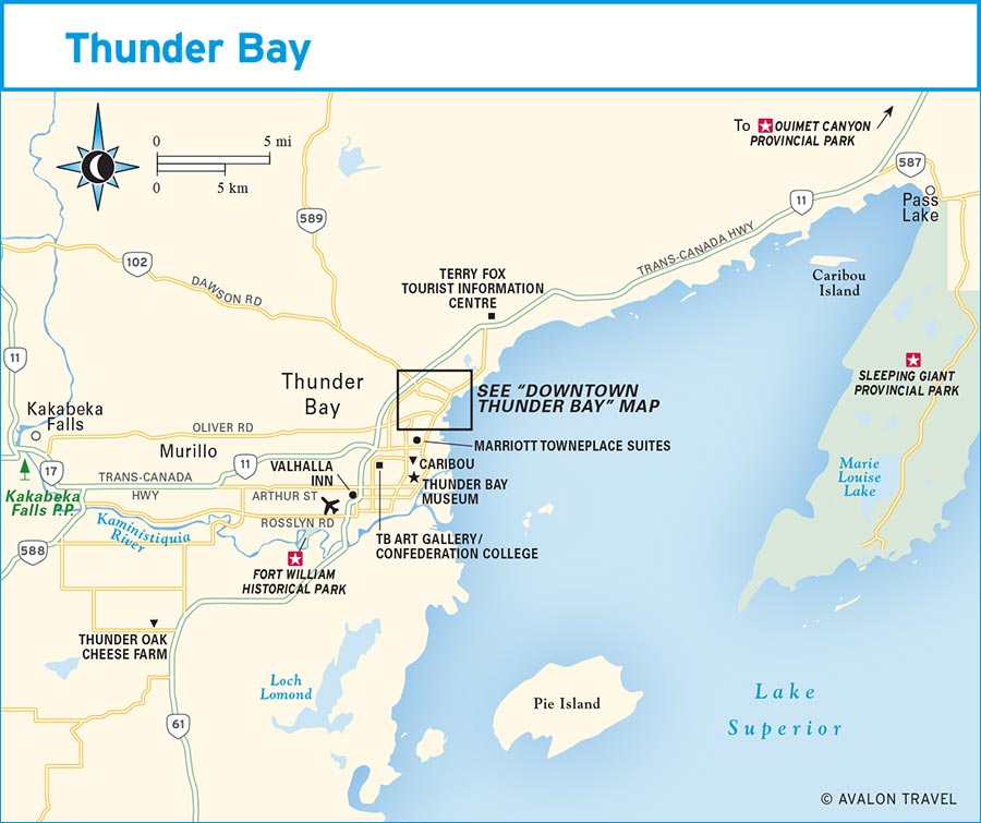
The present-day city of Thunder Bay, with a population of 120,000, grew out of two nearby towns: Fort William to the south and Port Arthur to the north. The city’s main downtown is now the northern one, around Water Street, Red River Road, and Marina Park. A smaller downtown district in former Fort William centers on Arthur and May Streets. Strip malls and big-box stores occupy much of the area between these two districts, creating a suburban strip inside the city rather than around the outskirts.
From Thunder Bay, you can set out on all manner of outdoor adventures. Three provincial parks—Sleeping Giant, Ouimet Canyon, and Kakabeka Falls—are within an hour’s drive of the city, and opportunities for hiking, kayaking, sailing, and other sports abound.
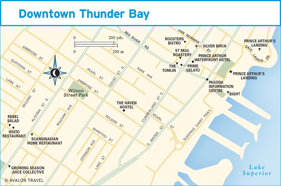
An interesting historic neighborhood to explore is the Bay & Algoma Historic District. Once a center of the region’s Scandinavian community, Bay Street still houses the Finnish Labour Temple and its well-loved Hoito Restaurant, a Scandinavian deli, and gift shops selling Scandinavian products and souvenirs. Around the corner, Algoma Street is morphing into a funkier strip, with a juice bar, tea purveyor, yoga studio, and other eclectic shops.
A public park extending along the lakeside marina, Prince Arthur’s Landing (Marina Park, Water St., www.thunderbay.ca) is filled with outdoor sculptures and ways to enjoy the outdoors. The park has become a major step toward reclaiming the city’s formerly industrial lakeshore.
Explore the park for its most distinctive feature: a diverse collection of public art. On the patio of the Water Garden Pavilion (which houses Bight Restaurant) are the graceful giant water droplets of Traveller’s Return by Andy Davies. In the aboriginal culture-inspired Spirit Garden, a series of panels on the Celebration Circle, by Randy Thomas and Roy Thomas, incorporates images from the artists’ Ojibwa culture. Throughout the park, literary quotes are etched into stones, on walls, and other unexpected locations; one example is Round Dance, by Sarain Stump, set into the ground on Pier 2: “Don’t break this circle / Before the song is over / Because all of our people / Even the ones long gone / Are holding hands.”
Three kilometers (1.9 miles) of trails for walking and cycling wind along Lake Superior’s lakeshore. Daredevils demonstrate their skills in the skateboard park, and in the Water Garden, kids play on the splash pad (it’s a skating rink in winter). One section of the park is designated as the International Tai Chi Park (www.pengyou-taiji.ca), where morning tai chi practitioners perform their graceful moves on the yin-yang practice pad.
In the Baggage Building Arts Centre (807/684-2063, 11am-5pm Tues.-Fri., noon-4pm Sat.-Sun.), in a former freight shed, there’s a small gallery and gift shop as well as periodic art workshops. Prince Arthur’s Landing has a regular schedule of movies, concerts, and other special events, including the weekly summer Live on the Waterfront concerts (6pm-9pm Wed. early July-Aug.). Find out what’s happening by checking the website of Tourism Thunder Bay (www.thunderbay.ca).
How many beaver pelts does it take to buy a wool blanket or a musket? You can travel back to the fur-trading days of the early 1800s at Fort William Historical Park (1350 King Rd., 807/473-2344, www.fwhp.ca, 10am-5pm daily June-mid-Aug., 10am-5pm Sat.-Sun. May and mid-Aug.-mid-Sept., mid-June-mid-Aug. adults $14, seniors and students $12, ages 6-12 $10, May-mid-June and mid-Aug.-mid-Sept. adults $12, seniors and students $11, ages 6-12 $9), a family-friendly living-history site on the banks of the Kaministiquia River.
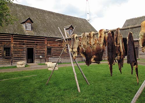
Animal pelts were a valuable trade commodity at Fort William.
Fort William served as the inland headquarters of the North West Company, a fur-trading operation based in Montreal that was established in 1783 as a rival to the Hudson’s Bay Company. Not a military outpost, Fort William was set up in 1803 as a trading post. It served as a rendezvous point between voyageurs—French Canadian traders who traveled several weeks by canoe from Quebec, bringing goods from eastern Canada and Europe—and the traders and their First Nations allies from the west who arrived bringing beaver pelts and other valuable furs. The fort was a vital link in Canada’s fur trade for over a decade. However, in 1821, the North West Company, facing stiff competition from the Hudson’s Bay Company, merged with its rival. Trade routes shifted, and the fort’s importance began to decline, until it closed permanently in the 1880s.
At the fort Visitors Centre, a short film introduces the history of the North West Company and its relationship with the region’s First Nations. Visitors then proceed to the fort itself, which has been reconstructed to represent life in 1815-1816. Tours of the fort, its 40-plus buildings, and its working farm run 60-90 minutes. You might start at the wigwams in the aboriginal encampment outside the fort, where costumed interpreters expand on First Nations life. Within the fort, you can visit the canoe shed, where the vessels that carried traders and their goods were built, or the fort doctor’s office, where your guide might demonstrate instruments used for pulling teeth or administering enemas. Another stop is the trading post, piled high with furs, where you learn the trade value of various pelts.
Beginning in the 1870s and continuing until World War I, immigrants from Finland settled in the Thunder Bay area. Some came to Canada seeking land to farm, and more found work in Northern Ontario’s burgeoning lumber and railroad industries. Subsequent waves of immigration—after World War I and later in the 1950s—continued to increase the number of Finnish settlers until the Thunder Bay region housed the largest community of Finns outside of Finland. Today, roughly 12,000 local residents claim Finnish ancestry.
For visitors, the region’s Finnish culture remains most accessible in two places: the restaurant and the sauna. Both locals and travelers have long flocked to eateries like Hoito Restaurant (314 Bay St., 807/345-6323, www.thehoito.ca) and the Scandinavian Home Restaurant (147 Algoma St. S., 807/345-7442, www.scandihs.com) for Finnish pancakes—plate-size hotcakes that are slightly thicker than a French crepe. Another locally popular treat is pulla, a cardamom-scented coffee bread, which you can find at Finnish bakeries and shops like the Scandinavian Delicatessen (307 Bay St., 807/344-3632), across the street from the Hoito, which sells other traditional food products from Finland, Sweden, Norway, and Denmark. The Scandinavian custom of smoking fish continues at the family-run Fish Shop (960 Lakeshore Dr., 807/983-2214, www.thefishshop.ca, Apr.-Dec.), where you can purchase ready-to-eat smoked trout, whitefish, and salmon—worth a detour on your way to or from Sleeping Giant Provincial Park.
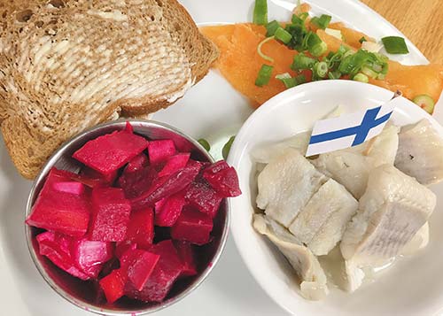
pickled herring plate at Hoito Restaurant
In Finland, saunas are an important element of the culture, providing both health benefits and social relaxation. In Thunder Bay, you can enjoy an in-town steam—solo, with friends, or with family members—at Kangas Sauna (379 Oliver Rd., 807/344-6761, www.kangassauna.ca). While it may not have the same cachet as a log sauna out in the woods, it has been providing locals with private sauna sessions for decades, and you’ll still sweat plenty. Saunas at Kangas rent for 90 minutes and include use of the communal hot tub. Prices vary depending on the number of people and the size of the sauna: small ($22 for 1 person, $30 for 2, $45 for 3, $60 for 4), medium ($30 for 1, $40 for 2, up to $100 for 5), and large ($30 for 1, $40 for 2, up to $120 for 6). Saunas include a changing room and shower. You can rent towels ($4). Bathing suits aren’t required (just lock your sauna door), although you have to wear suits in the hot tub. And if you haven’t had your fill of Finnish pancakes, the on-site restaurant serves ’em by the plateful.
In summer, you can talk with interpreters representing Scottish fur traders, French voyageurs, Ojibwa and Métis people, farmers, and others who “live” at the fort. You might also ride down the river in a voyageur canoe. Fewer hands-on activities are available between mid-September and April, when the fort is open by appointment only (10am-5pm Mon.-Fri., ages 6 and up $7.50); phone to reserve a tour time. The fort hosts special events throughout the year, including Anishnawbe Keeshigun (June), a festival of indigenous culture, and the Voyageur Winter Carnival (Feb.).
An on-site canteen (lunch $8-12) serves rib-sticking voyageur beef stew and French Canadian pea soup as well as more modern sandwiches and pizzas. To reach Fort William, which is south of Thunder Bay Airport, follow Highway 61 south, then turn west onto Broadway to the park.
The Thunder Bay Museum (425 Donald St. E., 807/623-0801, www.thunderbaymuseum.com, 11am-5pm daily mid-June-early Sept., 1pm-5pm Tues.-Sun. early Sept.-June, adults $3, ages 6-17 $1.50, free admission Tues.) recounts the region’s history through a series of small rooms, each reflecting a particular business or social organization: a school, a post office, a medical office, a shoemaker, a real estate office. Rotating exhibits showcase area architecture, military history, and music.
Focusing on regional artists, including aboriginal artists, the Thunder Bay Art Gallery (Confederation College Campus, 1080 Keewatin St., www.theag.ca, noon-8pm Tues.-Thurs., noon-5pm Fri.-Sun., donation $5, free admission Wed.) changes the displays in its three small exhibit rooms several times a year.
For a unique perspective on the islands of Lake Superior and the topography of the Sleeping Giant, take a 20- to 30-minute flight-seeing tour with Wilderness North (807/983-2047 or 888/465-3474, www.wildernessnorth.com, from $150 pp). You fly in a classic bush plane, a De Havilland Beaver, built in 1953. They can also fly you east of the Sleeping Giant to Porphyry Point Lighthouse (from $240 pp), where you can take a tour.
To experience Lake Superior from the water, book a cruise with Sail Superior (807/628-3333, www.sailsuperior.com), which takes passengers on 90-minute sailing tours of Thunder Bay harbor (daily mid-May-mid-Oct., adults $59, ages 11-18 $39, ages 3-10 $25), departing from Marina Park. They also run half-day excursions to the Welcome Islands ($465 for up to 8 people) and organize other day or overnight sailing trips. Another option is a full-day or overnight trip to the Porphyry Point Lighthouse (from $1,195 for up to 6 people) east of the Sleeping Giant, where you can stay in the refurbished lightkeeper’s residence.
The numerous cliffs around Thunder Bay and along Lake Superior’s North Shore are magnets for rock climbers. Climbing guide Aric Fishman launched Outdoor Skills and Thrills (807/472-4742, www.outdoorskillsandthrills.com) to offer rock climbing lessons for beginners (half-day $79, full-day $149) and intermediates (full-day $149), as well as a variety of private or small-group guided climbing adventures for climbers of all abilities. Rock climbing season is normally May through October; in winter (December to March), the company leads ice climbing programs.
Plan to attend the annual Savour Superior Food and Drink Festival (www.savoursuperior.com, Sept.) to sample what’s new and local from around the region. The rest of the year, visit the Thunder Bay Country Market (Dorothy Dove Bldg., Canadian Lakehead Exhibition grounds, off Memorial Ave., 807/622-1406, www.thunderbaycountrymarket.com, 8am-1pm Sat. year-round, 4pm-7pm Wed. late May-early Sept.) for local products, such as elk jerky, homemade pickles, and baked goodies; look for Boreal Birch Syrup (www.birchsyrup.ca)—an alternative to maple—and for several varieties of gouda from Thunder Oak Cheese Farm (807/628-0175 or 866/273-3329, www.cheesefarm.ca).
Originally opened to offer reasonably priced meals to Finnish bush workers when they came to the city (an average dinner in the 1930s cost 25 cents), S Hoito Restaurant (314 Bay St., 807/345-6323, www.thehoito.ca, 8am-7pm daily, breakfast $5-15, lunch and dinner $6-17) has become a Thunder Bay breakfast tradition, especially for its crepe-like Finnish pancakes, served plain or piled high with eggs, bacon, or ham. Expect weekend brunch lineups, but don’t expect high style; the restaurant is on the lower level of the 1910 Finnish Labour Temple, with all the atmosphere of a church basement. Later in the day, try the pickled herring or smoked salmon plates.
Like the Hoito around the corner, Scandinavian Home Restaurant (147 Algoma St. S., 807/345-7442, www.scandihs.com, 7am-8pm daily, $5-20) was established as part of a support network for Scandinavian immigrants. These days, families, visitors, and old-timers all pack this cheery Viking-themed diner for substantial all-day breakfasts and a mix of home-style and Scandinavian specialties, like the salted salmon sandwich and mojakka (Finnish beef stew). Of course, they’ve got Finnish pancakes, too.
A boisterous downtown bistro, The Tomlin (202 1/2 Red River Rd., 807/346-4447, www.tomlinrestaurant.com, 5pm-10pm Tues.-Thurs., 5pm-11pm Fri.-Sat., sharing plates $12-29) reels in a diverse crowd with creative cocktails like the Green Lily (a sparkling blend of cucumber, elderflower, and pisco) or the Tomlin Collins (made with olive oil-infused gin, fennel, and coriander tincture), and with a long list of Ontario microbrews. Bring your sense of adventure for the eclectic menu, too, with sharing plates like sweet-and-crispy chicken karaage, roasted cauliflower with charred corn and manchego, or grilled herring with salsa verde.
Its wallpaper adorned with photos of silvery trees, Silver Birch (28 N. Cumberland St., 807/345-0597, www.thesilverbirchrestaurant.com, 5pm-10pm Tues.-Sat., dinner $18-38) hums with quiet conversation and emphasizes northern ingredients in dishes like bacon-wrapped pickerel glazed with birch syrup or garlicky Caesar salad topped with bannock croutons and elk sausage chips. It often features wild game in dishes like elk shepherd’s pie. You can drink a “Birch Bark Canoe”—Crown Royal whisky with birch beer.
Choose a seat overlooking the waterfront or on the patio at lively Bight (2201 Sleeping Giant Pkwy, Unit 100, 807/622-4448, www.bightrestaurant.ca, 11:30am-10pm Sun.-Thurs., 11:30am-11pm Fri.-Sat., lunch $14-20, dinner $18-44) in Marina Park. The small plates range from poutine topped with braised beef short ribs and Thunder Oak cheese curds to inventive pizzas, while the more substantial entrees, with plenty of regional ingredients, might pair local whitefish with roasted root vegetables or duck breast with a sweet potato latke and fried Brussels sprouts.
Excellent pizza from the wood-burning oven, seasonal specialties like fresh corn salad, and internationally inspired entrées—perhaps duck with Korean-style barbecue sauce, piri piri chicken, or pasta with braised rabbit—make contemporary Caribou Restaurant & Wine Bar (727 Hewitson St., 807/628-8588, www.caribourestaurant.com, 5pm-10pm Mon.-Wed., 11:30am-2pm and 5pm-10pm Thurs., 11:30am-2pm and 4:30pm-11pm Fri., 4:30pm-11pm Sat., 5pm-9pm Sun.$16-33) a long-running favorite for dinner with family or friends.
It’s worth getting up when the cock crows for a hearty breakfast at Roosters Bistro (32 St. Paul St., 807/344-7660, www.roostersbistro.com, 8am-3pm daily, $6-16), a downtown diner serving morning classics with a Northern Ontario twist. Top your eggs Benedict with pan-fried walleye (a local fish) or pair your scramble with Finnish pancakes. At lunch, burgers and sandwiches rule the roost.
The aroma of freshly roasted coffee envelops you as you enter St. Paul Roastery (11 St. Paul St., 807/344-3900, 7:30am-5pm Mon.-Fri., 9am-5pm Sat.). Take a break at this hip brick-walled coffeehouse downtown with a pour-over or an espresso.
Squeezed into a tiny storefront, vegetarian-friendly Growing Season Juice Collective (201 Algoma St. S., 807/344-6869, www.growingseason.ca, 11am-8pm Mon.-Sat., $8-13) serves fresh-pressed juices and smoothies, sandwiches with locally made Thunder Oak gouda, and rice bowls. Try the sesame-ginger dressed Living Salad with greens, baked tofu, avocado, and sprouted lentils. The same team operates Rebel Salad (320 Bay St., 11am-8pm Mon.-Fri., $13-15), where you can customize your salad bowls with a mind-boggling array of ingredients, from roasted sweet potatoes to shredded beets to a chia-flax-sesame seed mix.
The ice cream masters at Prime Gelato (200 Red River Rd., 807/344-1185, www.primegelato.ca, noon-10pm daily summer, call or check the website for off-season hours) concoct inventive flavors, like miso caramel or apple pie, made with local ingredients or with products imported from Italy. Also on the menu are nondairy sorbettos, including lemon or red wine and pear.
To stay downtown, consider the Prince Arthur Waterfront Hotel (17 Cumberland St. N., 807/345-5411 or 800/267-2675, www.princearthurwaterfront.com, $137-185), a redbrick landmark built in 1911, a short stroll from the harbor. The aging property could use some TLC, but many of the 120 rooms are large, with fridges, microwaves, and one-cup coffeemakers; the best have lake views. The restaurant serves a basic continental breakfast. Rates include Wi-Fi, parking, and a complimentary shuttle to or from the airport.
New in 2018, The Haven Hostel (226 Ambrose St., 807/629-2225, www.thehavenhostel.ca, $45-50 dorm, $95-100 d), on a downtown side street, is targeting budget-minded travelers with simple private rooms with en suite baths, standard four-bed mixed dorms, and six-bed male or female “pod” dorms, where each pod, behind a curtain for privacy, has a locker, shelves, electrical outlet, and lighting. There’s a communal kitchen, lounge, and book exchange. Rates include Wi-Fi, continental breakfast, and all-day coffee and tea.
Also downtown, the upscale Marriott-Delta Hotel at Prince Arthur’s Landing (www.marriott.com), slated for completion in 2018, will overlook the city’s waterfront. The location opposite the lake is fantastic; get updates on opening dates and prices online.
There’s nothing picturesque about the surroundings of the Marriott Towneplace Suites (550 Harbour Expressway, 807/346-9000, www.marriott.com, $144-269 d), overlooking the parking lot of a big-box store. Still, as one of Thunder Bay’s newer chain motels, this family-friendly five-story property covers the essentials: colorful modern studio, one-, and two-bedroom suites with full kitchens, granite countertops, flat-screen TVs, and free Wi-Fi; a modest complimentary breakfast; a compact pool and fitness facility; and a central location.
Convenient if you’re traveling by air or exploring attractions surrounding Thunder Bay, Valhalla Inn (1 Valhalla Inn Rd., 807/577-1121 or 800/964-1121, www.valhallainn.com, $134-219 d) is adjacent to the city’s airport. Recent renovations have upgraded this older 264-room property with white duvets, electrically equipped desks, and free Wi-Fi.
Tourism Thunder Bay (www.thunderbay.ca) runs two local visitor information centers that are both attractions as well. On a hill east of the city, the Terry Fox Tourist Information Centre (off Highway 11/17, 1 km/0.6 miles east of Hodder Ave., 807/983-2041 or 800/667-8386, 8:30am-7pm daily mid-June-early Sept., 9am-5pm daily Sept.-mid.-June) looks out across Lake Superior to the Sleeping Giant, but it’s worth stopping to see the 2.7-meter (nine-foot) bronze statue of Terry Fox. A young British Columbia man, Fox embarked on a cross-Canada run in 1980 to raise money for cancer research after losing his own leg to the disease. He unfortunately had to stop his “Marathon of Hope” as he neared Thunder Bay, after running 5,342 kilometers (3,339 miles). Though Fox succeeded in raising more than $24 million, his own cancer had returned and would end his life at age 22 on June 28, 1981.
Downtown near Marina Park, the distinctively shaped Pagoda Information Centre (Water St. at Red River Rd., 807/684-3670, 10am-6pm Tues.-Sat. June-early Sept.) claims to be Canada’s oldest continuously operating tourism office, dating back to 1909.
For the scoop on the city’s arts and entertainment scene, check out The Walleye (www.thewalleye.ca), the local alternative arts and culture publication.
Thunder Bay International Airport (YQT, 100 Princess St., off Hwy. 61, 807/473-2600, www.tbairport.on.ca) is southwest of the city center. Air Canada (www.aircanada.com) and Westjet (www.westjet.com) fly to Thunder Bay from Toronto’s Pearson Airport and from Winnipeg; Porter Airlines (www.flyporter.com) has flights from Billy Bishop Toronto City Airport. Bearskin Airlines (www.bearskinairlines.com) flies between Thunder Bay and Sault Ste. Marie and to several towns in Northwestern Ontario. Wasaya Airways (www.wasaya.com) flies to several northern communities.
Buses run to the Thunder Bay Greyhound Bus Station (815 Fort William Rd., 807/345-2194 or 800/661-8747, www.greyhound.ca) from Sault Ste. Marie (9.75 hours, $72-181), Toronto (20.75 hours, $137-295), and Winnipeg (9.5 hours, $62-142).
Thunder Bay is approximately 700 kilometers (435 miles) northwest of Sault Ste. Marie and the same distance east of Winnipeg. It’s 80 kilometers (50 miles), along Highway 61, from the U.S. border near Grand Portage, Minnesota. Toronto to Thunder Bay is 1,375 kilometers (860 miles)—a two-day drive. If you’re interested in exploring Lake Superior and other points in Northwestern Ontario, consider flying to Thunder Bay and either renting a car or arranging with a local outfitter for onward transportation. All the major car rental companies have Thunder Bay offices.
Highway 11/17, the Trans-Canada Highway, skirts the western side of Thunder Bay. From the east, Hodder Avenue will take you toward downtown and the marina. The Harbour Expressway runs east-west from the Trans-Canada to Fort William Road, close to the lakeshore.
Thunder Bay’s attractions are scattered throughout the surrounding region, making it challenging to explore without a car. Within the city, you can get to many destinations on buses run by Thunder Bay Transit (807/684-3744, www.thunderbay.ca/transit, $2.75).
TOP EXPERIENCE
From Thunder Bay’s waterfront, you can see a hulking forested peninsula looming just offshore. If you look closely, and use your imagination, you can glimpse in the peninsula’s terrain the reclining profile of a gigantic humanlike figure, its arms crossed over its chest. The Ojibwa have many legends surrounding the creation of this Sleeping Giant, which they call Nanabijou, the Spirit of the Deep Sea Water. In one tale, Nanabijou was turned to stone after the location of the peninsula’s rich silver deposits was disclosed to outsiders. Regardless of its origin, this craggy neck of land with cliffs rising 240 meters (780 feet) above the lake has become one of Lake Superior’s most iconic outdoor destinations.
An hour’s drive east of Thunder Bay on the Sibley Peninsula, vast Sleeping Giant Provincial Park (Pass Lake, 807/977-2526, www.ontarioparks.com, $14.50 per vehicle) offers lots of opportunities for visitors to enjoy the outdoors. The park’s boreal forest is home to moose, wolves, deer, foxes, and lynx. You can fish for yellow perch and northern pike in several inland lakes; in the park’s largest lakes, you might catch walleye or smallmouth bass. Birders, take note: more than 200 avian species have been spotted in the region.
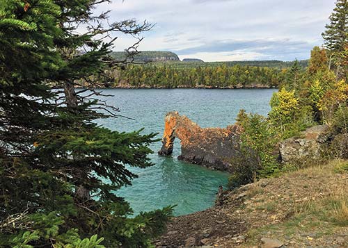
In Sleeping Giant Provincial Park, this “sea lion” rock formation gives the Sea Lion Trail its name.
Near the park’s northern entrance, Thunder Bay Lookout—atop some of Ontario’s highest cliffs—has views across the lake to the city of Thunder Bay. If you’re not afraid of heights, peer through the slatted lookout platform to the cliffs and rocky shores below. The nine-kilometer (5.5-mile) gravel and dirt road to the lookout can be steep and potholed in sections, but once you arrive in the parking lot, the lookout is only a minute’s walk away.
The Visitors Centre and park information office are at Marie Louise Lake, near the park’s south end, where the main campground is also located. The Visitors Centre rents watercraft (two hours $15, four hours $25), including canoes, kayaks, and stand-up paddleboards, as well as mountain bikes (four hours $20). In summer, park staff run numerous interpretive programs, including nature walks, campfires, and children’s activities.
Sleeping Giant has more than 100 kilometers (60 miles) of hiking trails that range from easy lakeside strolls to challenging daylong or multiday adventures. Because weather along Lake Superior can change rapidly, always carry rain gear and warm clothing, even if the sun is shining when you set out.
The park’s signature hike is the Top of the Giant, a 22-kilometer (14-mile) round-trip climb across the peninsula’s southern sections to scenic lookouts across Lake Superior. Starting from the Kabeyun South trailhead, this route follows several different trails. The Kabeyun Trail leads past Tee Harbour, where it meets the Talus Lake Trail; from there, you continue toward the Top of the Giant, where an additional two-kilometer (1.25-mile) steady climb leads to one of Ontario’s highest lookout points. Park staff caution that you shouldn’t attempt this tough hike unless you’re in good physical condition, but dramatic views are the hiker’s reward.
A far easier path is the Sea Lion Trail, a mostly flat, 2.5-kilometer (1.5-mile) walk to the lakeshore, where an unusual rust-tinged, vaguely animal-shaped geological formation jutting into the water gives the route its name. The Sea Lion Trail branches off from the Kabeyun Trail toward the park’s southern end. Other day hikes include the family-friendly Sibley Creek Trail (2.3 km, 1.4 miles, round-trip) that starts from the Marie Louise Lake campground; the Wildlife Habitat Trail (2.1 km, 1.3 miles, round-trip), where you might spot deer or even moose; and the Middlebrun Bay Trail (10 km, 6 miles, round-trip), which traverses wetlands en route to a sandy beach.
Seasoned backpackers can explore the dramatic 37-kilometer (23-mile) linear Kabeyun Trail, which begins at the Thunder Bay Lookout and follows the coast around the Sleeping Giant.
Experienced cyclists can tackle several park trails and roads by mountain bike. The Sawyer Bay, Sawbill Lake, Burma, and Pickerel Lake Trails are open to mountain bikers, as is a section of the South Kabeyun Trail to the junction with Talus Lake Trail. Cyclists can pedal the steep rutted road to the Thunder Bay Lookout and the easier route along Marie Louise Drive, which starts from the campground.
When the snow falls, the park grooms 50 kilometers (31 miles) of trails for cross-country skiing and snowshoeing. The Visitors Centre remains open as a warming station and restroom stop for winter adventurers.
Marie Louise Lake Campground (www.ontarioparks.com, mid-May-mid-Oct., tent sites $42-45, electrical sites $47-52) has 200 campsites, including 85 with electrical service. The campground’s comfort stations have hot showers and laundry facilities. It’s a short walk to a swimming beach and playground. Also in the campground are five cabins (year-round, $169.50). Sleeping six, each cabin has three bedrooms (one with a double bed and two with bunk beds), a kitchen, bath, and sunporch. Linens, dishes, and cooking equipment are provided. The park rents three camping trailers (May-Oct., $98-142), which also sleep six. Although the trailers have showers, air-conditioning, and TV, you need to bring your own bedding and walk to the nearby campground for toilets.
Book campsites, cabins, or trailers up to five months in advance through the Ontario Parks Reservation Service (888/668-7275, www.ontarioparks.com, reservation fee online $11, by phone $13).
Because Sleeping Giant’s territory spreads across 244 square kilometers (60,300 acres), it’s not a quick drive-in, drive-out destination. Plan to spend at least a full day to explore the park. The park turnoff from Highway 17 is Highway 587 south at Pass Lake, 50 kilometers (32 miles) east of Thunder Bay. From there, it’s another 30 kilometers (19 miles) south to the Visitors Centre and main campground at Marie Louise Lake.
Northern Ontario has plenty of places where the forested landscape gives way to more extreme topography. Ouimet Canyon, in the small Ouimet Canyon Provincial Park (Ouimet Canyon Rd., Dorion, 807/977-2526, www.ontarioparks.com, mid-May to mid-Oct., $2), is one of those places. Carved by natural forces over millions of years, Ouimet Canyon is a 150-meter (495-foot)-wide gorge with jagged cliffs on either side. An easy one-kilometer (0.6-mile) loop trail leads to two lookout points, 100 meters (330 feet) directly above the canyon floor.
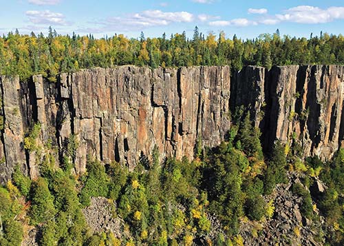
jagged cliffs at Ouimet Canyon Provincial Park
The canyon is especially striking in the fall when clusters of trees and plants turn gold and red; autumn colors are typically the most vibrant from the second half of September through early October. While it’s difficult to tell from above, several varieties of arctic plants, normally found in much more northern regions, thrive on the canyon floor. In part to protect this fragile vegetation, visitors are not allowed into the canyon.
Ouimet Canyon is a day-use park, with no camping facilities. Most visitors come from Thunder Bay or stop off as they’re driving along Lake Superior’s North Shore. You can combine a stop at Ouimet Canyon with a day at Sleeping Giant Provincial Park. The Ouimet Canyon turnoff from Highway 11/17 is 75 kilometers (47 miles) east of Thunder Bay and 35 kilometers (22 miles) west of Nipigon.
The Ouimet Canyon area has two other points of interest.
Off Ouimet Canyon Road, Eagle Canyon Adventures (275 Valley Rd., Dorion, 807/355-3064, www.eaglecanyonadventures.ca, 10am-6pm daily May-mid-Oct., adults $20, ages 4 and over $10) boasts Canada’s longest suspension bridge, a 183-meter (600-foot) span high above a canyon. If that’s not enough adventure, there’s a second 92-meter (300-foot) suspension bridge to cross, as well as a zip line ($60) that whizzes you through the air for more than 800 meters (0.5 miles).
Some of the rocks and boulders around the Lake Superior region are rich with amethysts, and Amethyst Mine Panorama (500 Bass Lake Rd., Shuniah, 807/622-6908, www.amethystmine.com, 10am-5pm daily mid-May-June and Sept.-mid-Oct., 10am-6pm daily July-Aug., ages 6 and over $8), part working mine and part tourist attraction, is Canada’s largest amethyst deposit. The stones were discovered here in 1955, and the mine has been operating since 1960.
Your admission price includes a 5- to 10-minute tour that covers the mine’s history and facts about amethyst. What’s more entertaining, particularly for the kids, is to dig for your own amethysts in the rock-studded field. If you’d like to keep what you dig up, it’s $3 per pound. A gift shop sells amethyst jewelry, decorative stones, and other products.
The turnoff for the mine from Highway 11/17 is at East Loon Road, 55 kilometers (35 miles) east of Thunder Bay. From there, it’s about 8 kilometers (5 miles) along a well-marked, mostly dirt road to the mine.
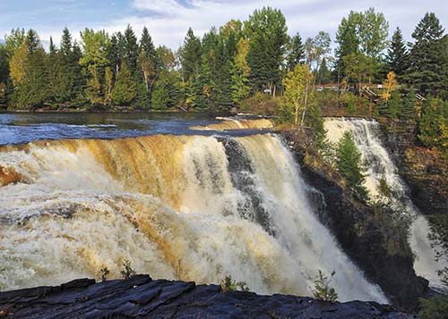
Kakabeka Falls
Northern Ontario’s largest waterfall is located in Kakabeka Falls Provincial Park (Hwy. 11/17, Kakabeka Falls, 807/453-9231, www.ontarioparks.com, year-round, $14.50 per vehicle), a 30-minute drive west of Thunder Bay. Viewing platforms and boardwalk paths on both sides of the Kaministiquia River give you excellent vantage points for admiring the 40-meter (130-foot)-high falls. Sometimes called the “Niagara of the North,” Kakabeka is a more modest than its famous southern neighbor yet still an impressive cascade of water.
In addition to the boardwalk trail overlooking the falls, Kakabeka has several longer hiking routes. The easy Mountain Portage Walking Trail, a 1.25-kilometer (0.75-mile) loop, follows the portage route that early explorers took to bypass the falls. The 2.5-kilometer (1.5-mile) Little Falls Walking Trail is another loop with views along the river and a climb up the Mountain Portage. Upriver from the falls, there’s a small beach and riverside swimming area.
The park has 169 campsites (www.ontarioparks.com, mid-May-mid-Oct., tent sites $36-42, electrical sites $42-47) in three campgrounds. Whispering Hills Campground is in the woods up a steep road from the falls; it has central showers and laundry facilities. Bordering the Kaministiquia River, the Riverside Campground and the adjacent Fern’s Edge Campground have vault toilets as well as central flush toilets but no showers.
Kakabeka Falls Provincial Park is 35 kilometers (22 miles) west of Thunder Bay, off Highway 11/17. Unless you plan to camp, most visitors day-trip from Thunder Bay. If you’re taking a quick look at the falls and moving on, pay for parking by the hour instead of buying a full-day pass. The park Visitors Centre (late May-mid-Oct.) on the river’s west bank provides information and runs summer interpretive programs.
You’ll find basic services, including a couple of places to eat, just east of the park in the village of Kakabeka Falls. For coffee, fresh baked goodies, and light meals, stop into the cabin that houses Metropolitan Moose Beanery & Café (4770 Hwy. 11/17, Kakabeka Falls, 807/473-5453).