![]()
THE MAPS which follow show the distribution of some of the rarer and more interesting chalk and limestone flowers and ferns. They have been chosen to illustrate the restricted distribution of certain species in spite of the widespread occurrence of calcareous soils. The opportunity has been taken of including more than one flower on nine of the maps in order to show striking contrasts in types of distribution. On Maps 3, 4, 5, 9 and 11 these contrasts are between species belonging to the same genera.
The markings indicate localities from which the plants have been recorded and are based on published records, herbarium specimens and the writer’s own field-work. In this way the true distribution is shown very much more accurately than by the more usual method of shading in whole divisions of counties (Watsonian Vice-counties) irrespective of whether the species has been found in a single locality or many. Nevertheless, it must be remembered that some parts of the British Isles have been investigated more thoroughly than others, and that some are covered by excellent modern local floras while others have only old floras or even none. For these reasons it is difficult to compile detailed distribution maps with absolute accuracy. The small scale employed has made it necessary in some cases to show groups of adjacent localities by single marks.
Localities are marked with the signs •, ![]() and
and ![]() . These signs are placed in a circle for places where the species is believed to be extinct. In the case of the Military Orchid, the new locality mentioned in Chapter 7 is not shown. A few records regarded as doubtful (either for determination or locality) are shown as a “?.”
. These signs are placed in a circle for places where the species is believed to be extinct. In the case of the Military Orchid, the new locality mentioned in Chapter 7 is not shown. A few records regarded as doubtful (either for determination or locality) are shown as a “?.”
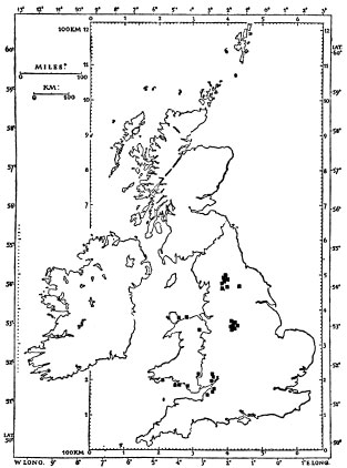
2. Rock Pepperwort, Hornungia petraea. (Some doubtful or alien records are excluded) (![]() )
)
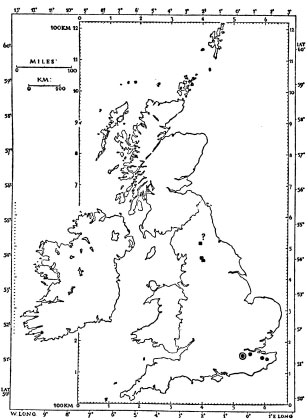
4. a. Bitter Milkwort, Polygala amara (![]() )
)
b. Kentish Milkwort, P. austriaca ( • )
5. a. Yorkshire Sandwort, Arenaria gothica ( • )
b. Norwegian Sandwort, A. norvegica (![]() )
)
c. Irish Sandwort, A. ciliata subsp. hibernica (![]() )
)
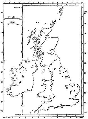
6. a. Perennial Flax, Linum anglicum (some doubtful records not shown) (![]() )
)
b. Hair-leaved Goldilocks, Crinitaria linosyris ( • )
7. a. Honewort, Trinia glauca ( • )
b. Mountain Stone-parsley, Seseli libanotis (![]() )
)
c. Baneberry, Actaea spicata (![]() )
)
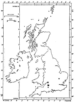
8. Tuberous Thistle, Cirsium tuberosum (![]() )
)
9. a. Spring Gentian, Gentiana verna (![]() )
)
b. Large Autumn Gentian, Gentianella germanica ( • and ?—all queries refer to this species and most are due to errors of identification)
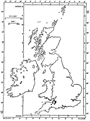
10. Blue Gromwell, Lithospermum purpurocaeruleum (![]() )
)
11. a. Western Spiked Speedwell, Veronica spicata subsp. hybrida (![]() )
)
b. Spiked Speedwell, V. spicata subsp. spicata ( • )
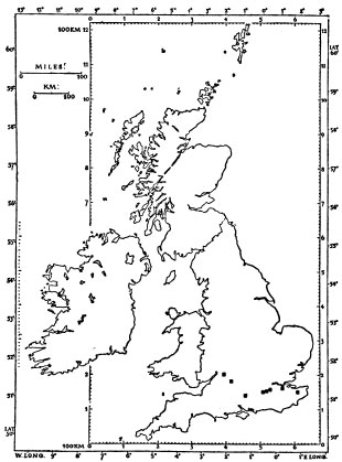
12. Cut-leaved Germander, Teucrium botrys (![]() )
)
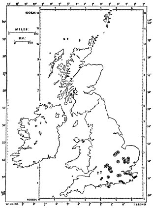
14. Early Spider Orchid, Ophrys sphegodes (![]() )
)
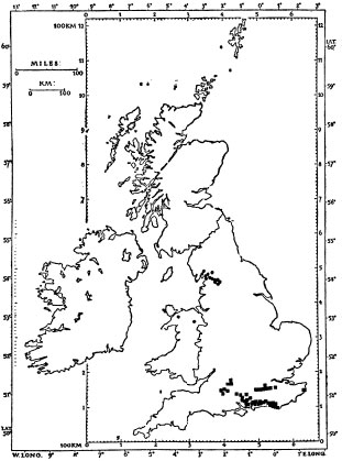
16. a. Roundheaded Rampion, Phyteuma tenerum (![]() )
)
b. Rigid Buckler Fern, Dryopteris villarii ( • )