Mto wa Mbu
![]() %027 / Pop 11,400
%027 / Pop 11,400
Mto wa Mbu is the busy gateway to Lake Manyara, which is fed by the town’s eponymous ‘River of Mosquitoes’, and you'll pass through here en route between Arusha and Ngorongoro. Over the years, this diverse place – by some estimates, all of Tanzania's 120 tribal groups are present here – has evolved into something of a travellers centre, with plenty of lodges, campsites, hole-in-the-wall eateries, petrol stations, money changers, souvenir stalls and just about anything else that could tempt a passing safari vehicle to disgorge its inhabitants.
The well-organised Mto wa Mbu Cultural Tourism Program (
GOOGLE MAP
; ![]() %027-253 9303, 0784 606654; http://mtoculturalprogramme.tripod.com; day trip from US$30;
%027-253 9303, 0784 606654; http://mtoculturalprogramme.tripod.com; day trip from US$30; ![]() h8am-6.30pm) offers walking and cycling tours to surrounding villages, markets and a nearby waterfall, with an emphasis on farming, and hiking along the escarpment. Homestays and meals with local families can also be arranged. The office is at the back of the Red Banana Cafe, close to the bus stop on the main road.
h8am-6.30pm) offers walking and cycling tours to surrounding villages, markets and a nearby waterfall, with an emphasis on farming, and hiking along the escarpment. Homestays and meals with local families can also be arranged. The office is at the back of the Red Banana Cafe, close to the bus stop on the main road.
CRDB (
GOOGLE MAP
; ![]() h8am-4pm Mon-Fri, to noon Sat) on the main road has a sometimes-functional ATM.
h8am-4pm Mon-Fri, to noon Sat) on the main road has a sometimes-functional ATM.
LOCAL KNOWLEDGE
LOCAL MARKETS
Consider timing your arrival in the area around the Crater Highlands, Lake Natron and Mto wa Mbu to coincide with one of the region's weekly markets. They're social as well as commercial events, and, with the partial exception of the market in Mto wa Mbu, almost entirely local affairs. Market days:
Monday Engaruka Juu
Wednesday Selela
Thursday Engaresero, Engaruka Chini and Mto wa Mbu
4Sleeping & Eating
The best area to look for budget guesthouses is south of the main road behind the market.
Maryland ResortGUESTHOUSE$
(
GOOGLE MAP
; ![]() %0756 740948; www.facebook.com/Marylandhotel; camping Tsh10,000, s/d from Tsh40,000/50,000, d with shared bathroom Tsh28,000;
%0756 740948; www.facebook.com/Marylandhotel; camping Tsh10,000, s/d from Tsh40,000/50,000, d with shared bathroom Tsh28,000; ![]() p)
p)
Signposted off the main road just before the Lake Manyara National Park gate, this bright-peach building is meticulously maintained by the friendly owner, who lives on-site. Most of the nine rooms are on the small side, but with hot water and cable TV they’re priced right. Meals are available by request, and there’s a kitchen.
Twiga Campsite & LodgeHOSTEL$$
(
GOOGLE MAP
; ![]() %0784 901479, 0758 510000; www.twigalodgecampsite.com; Arusha-Karatu Rd; camping US$10, r US$50-100;
%0784 901479, 0758 510000; www.twigalodgecampsite.com; Arusha-Karatu Rd; camping US$10, r US$50-100; ![]() p
p![]() i
i![]() s)
s)
This popular place is a real travellers hub, with simple but well-kept standard rooms, bungalows and a decent campsite. It's a good place to hook up with other safari-goers, and bike and vehicle hire is available.
Njake Jambo Lodge & CampsiteCAMPGROUND$$
(
GOOGLE MAP
; ![]() %027-250 5553; www.njake.com; Arusha-Karatu Rd; camping/s/d US$10/95/130;
%027-250 5553; www.njake.com; Arusha-Karatu Rd; camping/s/d US$10/95/130; ![]() W
W![]() s)
s)
A base for both independent travellers and large overland trucks, Njake Jambo has a shaded and well-maintained grassy camping area, plus 16 good rooms in double-storey chalet blocks.
Blue Turaco Pizza PointPIZZA$$
(
GOOGLE MAP
; Arusha-Karatu Rd; pizzas Tsh12,000-16,000; ![]() hnoon-9pm)
hnoon-9pm)
The Blue Turaco Pizza Point, unmissable along the south side of the main road, makes good wood-fired pizzas. Seating is in a small courtyard area just behind.
8Getting There & Away
Buses and dalla-dallas run all day from Arusha (Tsh7000, two hours) and Karatu (Tsh2500, one hour) to Mto wa Mbu. You can also come from Arusha on the minibuses that run to Karatu. All vehicles stop along the main road in the town centre.
Car hire for trips to Lake Manyara and Tarangire National Parks (including fuel and driver US$150 to US$200) and to Ngorongoro Crater (US$200 to US$250) is available in Mto wa Mbu through the Cultural Tourism Program office and Twiga and Njake Jambo campsites.
The track north to Lake Natron begins here.
Lake Manyara National Park
One of Tanzania’s smaller and most underrated parks, Lake Manyara National Park (
GOOGLE MAP
; ![]() %027-253 9112, 0767 536137; www.tanzaniaparks.go.tz; adult/child US$53.10/17.70;
%027-253 9112, 0767 536137; www.tanzaniaparks.go.tz; adult/child US$53.10/17.70; ![]() h6am-6pm) has a wide range of ecosystems – 11 in all. While it may lack the size and variety of other northern-circuit destinations (there's pretty much one main north–south route through the park), its vegetation is diverse, ranging from savannah to marsh to evergreen forest, and it supports one of the highest biomass densities of large mammals in the world. The chance to see elephant families moving through the forest or Lake Manyara's famous population of tree-climbing lions (although sighting them is becoming increasingly rare) are alone reason enough to come.
h6am-6pm) has a wide range of ecosystems – 11 in all. While it may lack the size and variety of other northern-circuit destinations (there's pretty much one main north–south route through the park), its vegetation is diverse, ranging from savannah to marsh to evergreen forest, and it supports one of the highest biomass densities of large mammals in the world. The chance to see elephant families moving through the forest or Lake Manyara's famous population of tree-climbing lions (although sighting them is becoming increasingly rare) are alone reason enough to come.
The dramatic western escarpment of the Rift Valley forms the park’s western border. To the east is the alkaline Lake Manyara, which covers one-third of the park but shrinks considerably in the dry season. During the rains, the lake hosts millions of flamingos and other bird life.
LAKE MANYARA NATIONAL PARK
Why Go Excellent birding; tree-climbing lions; dramatic Rift Valley Escarpment scenery.
When to Go Year-round. June to October is best for large mammals; November to June is best for birds.
Practicalities Stay in Mto wa Mbu, atop the escarpment or inside the park; bring binoculars, as flamingos can be distant, depending on the day. Entrance fees are paid by credit card at the main gate.
Budget Tips Stay in Mto wa Mbu to avoid camping fees; charter a dalla-dalla for the day.
1Sights & Activities
The park is also notable for its raised treetop walkway (
MAP
GOOGLE MAP
; ![]() %0756 977384; www.wayoafrica.com/treetop-walkway; US$35.40, plus treetop park fee US$17.70;
%0756 977384; www.wayoafrica.com/treetop-walkway; US$35.40, plus treetop park fee US$17.70; ![]() h6.30am-5pm), Tanzania's first.
h6.30am-5pm), Tanzania's first.
Entry fees are valid for 24 hours, for a single entry only – worth remembering if you're thinking of returning to your hotel outside the park for lunch; bring a picnic lunch instead.
TREE-CLIMBING LIONS
Lions climb trees in other parks, too, but it’s a real speciality of Manyara's lions – scientists speculate that they may have developed the habit to escape a nasty biting fly that devastated the Ngorongoro Crater lion populations back in the 1960s. Tracking the lions down can be tricky, but it's worth the effort.
Wildlife Drives
Just inside the park's main gate, the northern woodland is dense, green and overrun by baboon troops; sightings of blue monkeys are also possible. There's a hippo pool at the lake's northernmost tip. Between the water's edge and the steep Rift Valley walls, the floodplains host wildebeest, buffaloes, zebras and Lake Manyara's much-studied elephants, while the thin acacia belt that shadows the lakeshore is where you're most likely to see arboreal lions.
Lake Manyara is the only northern-circuit park where anybody (not just guests at certain hotels) can do night drives. They're run by Wayo Africa from 8pm to roughly 11pm (US$50 per person, plus the park fee of US$59/23.60 per adult/child). Park fees must be paid directly to the park before 5pm. Advance booking (and usually advance payment) is required.
Walking Safaris
The park allows two- to three-hour walking safaris (US$23.60 per person, plus US$23.60 per group of up to eight) with an armed ranger along three trails. Reservations are required and the park has no vehicles to take hikers to the trailheads.
The Msara Trail, the nearest path to the gate (11km away), follows its namesake river along the Rift Valley Escarpment through great birdwatching territory up to a viewpoint. The Lake Shore Trail starts 38km into the park near the maji moto (hot springs). It crosses acacia woodland and savannah and is the path where walkers are most likely to meet large mammals and find flamingos. The Iyambi River Trail, 50km from the gate, is wooded and rocky with good birdwatching and a chance to see mammals.
Wayo Africa has three walking options (US$18 to US$35 per person) in the area: a nature walk along the escarpment, a forest walk down the escarpment, and a village walk in Mto wa Mbu. All start from the Lake Manyara Serena Safari Lodge or a pre-arranged point in Mto wa Mbu.
4Sleeping & Eating
There are several mostly upmarket options within park boundaries, plus cheaper park-run accommodation. The latter includes park bandas ( GOOGLE MAP ; www.tanzaniaparks.go.tz; bandas per person US$35.40) and a public campsite ( GOOGLE MAP ; www.tanzaniaparks.go.tz; camping US$35.40) just inside the gate, as well as another public campsite (Riverside, Endabash; GOOGLE MAP ; www.tanzaniaparks.go.tz; camping US$35.40) near the Endabash River, about an hour's drive from the park gate. There are also several good midrange and top-end places atop the escarpment, outside park boundaries; most have sweeping views over the lake. Mto wa Mbu is another good base, especially for budget travellers.
In the Park
![]() oLake Manyara Tree LodgeLODGE$$$
oLake Manyara Tree LodgeLODGE$$$
(
GOOGLE MAP
; ![]() %028-262 1267; www.andbeyond.com; per person full board & incl all activities Jun-Sep US$1340, rest of year rates vary;
%028-262 1267; www.andbeyond.com; per person full board & incl all activities Jun-Sep US$1340, rest of year rates vary; ![]() hclosed Apr;
hclosed Apr; ![]() p
p![]() W
W![]() s)
s)
This lovely, luxurious place is one of the most exclusive lodges in all of Tanzania. The gorgeous stilted tree-house suites with private decks and views from the bathtubs and outdoor showers are set in a mahogany forest at the remote southern end of the park. The food is excellent and the rooms have butler service.
On the Escarpment
Panorama Safari CampsiteCAMPGROUND$
(
MAP
GOOGLE MAP
; ![]() %0763 075130; www.panoramasafaricamp.com; camping per tent US$10, permanent tents/igloos per person US$12/25)
%0763 075130; www.panoramasafaricamp.com; camping per tent US$10, permanent tents/igloos per person US$12/25)
Located near the top of the escarpment is this hot, sometimes dusty place with camping and faded warm-water ablutions. The price is great, however, and the views are as wonderful as those at any of the nearby luxury lodges. There's also a restaurant. Dalla-dallas running between Mto wa Mbu and Karatu will drop you at the entrance.
![]() oEscarpment Luxury LodgeLODGE$$$
oEscarpment Luxury LodgeLODGE$$$
(
MAP
GOOGLE MAP
; ![]() %0767 804864; www.escarpmentluxurylodge.com; s/d full board & incl all activities US$850/1100;
%0767 804864; www.escarpmentluxurylodge.com; s/d full board & incl all activities US$850/1100; ![]() p
p![]() i
i![]() s)
s)
The wood-floored chalets at this attractive place are the height of luxury – plenty of space, wonderfully deep bathtubs, leather sofas, tasteful recycled furnishings, wide verandahs, the finest linens and big windows. Views of the lake are as expansive as you'd expect from up here on the escarpment.
Lake Manyara Serena Safari LodgeLODGE$$$
(
MAP
GOOGLE MAP
; ![]() %027-254 5555; www.serenahotels.com; s/d full board Jul-Oct US$301/509, Nov-Jun s US$114-256, d US$228-433;
%027-254 5555; www.serenahotels.com; s/d full board Jul-Oct US$301/509, Nov-Jun s US$114-256, d US$228-433; ![]() p
p![]() i
i![]() W
W![]() s)
s)
The 67 well-appointed rooms in this large complex occupy appealing two-storey conical thatched bungalows in shady grounds. Nature walks and village visits are available, as is massage. There's no extra cost for the fine views (the best are from the swimming pool). It lacks the intimacy and naturalness of other escarpment properties but is nevertheless a justifiably popular choice.
Kirurumu Manyara LodgeTENTED CAMP$$$
(
GOOGLE MAP
; ![]() %027-250 7011; www.kirurumu.net; s/d with full board US$275/475)
%027-250 7011; www.kirurumu.net; s/d with full board US$275/475)
A unpretentious ambience, closeness to nature and memorable cuisine are the hallmarks of this well-regarded camp. It’s about 6km down a rough road from the main road, with views of Lake Manyara in the distance and a bush feel up close. Tents are well spaced amid the vegetation. Maasai-guided ethno-botanical and sunset walks are free, and fly camping can be organised.
Below the Escarpment
Manyara Wildlife Safari CampLODGE$$$
(
MAP
GOOGLE MAP
; ![]() %0712 332211; www.wildlifecamp.co.tz; s/d with full board US$275/350;
%0712 332211; www.wildlifecamp.co.tz; s/d with full board US$275/350; ![]() p
p![]() s)
s)
Tastefully furnished safari tents and stilted cottages with tiled floors and four-poster beds, all on the plains close to Lake Manyara, make this a good choice if being close to the lake is a priority. It's a 15-minute drive to the park gate, and signposted off the main road.
Migunga Tented CampTENTED CAMP$$$
(
MAP
GOOGLE MAP
; ![]() %0754 324193; www.moivaro.com; camping US$10, s/d/tr full board US$247/348/450;
%0754 324193; www.moivaro.com; camping US$10, s/d/tr full board US$247/348/450; ![]() p
p![]() i)
i)
The main attraction of this place (still often known by its previous name, Lake Manyara Tented Camp) is its setting in a grove of enormous fever trees (migunga in Swahili) that echoes with bird calls. The 21 tents ringing large, grassy grounds are small but adequate, and they're fairly priced. The camp is 2km south of the main road.
Ol Mesera Tented CampTENTED CAMP$$$
(
MAP
GOOGLE MAP
; ![]() %0784 428332; www.ol-mesera.com; s/d with full board US$120/200;
%0784 428332; www.ol-mesera.com; s/d with full board US$120/200; ![]() p
p![]() i)
i)
Run by a sprightly Slovenian pensioner, this personalised place, in a bush setting amid baobab and euphorbia trees, has four straightforward safari tents and is an ideal spot to do cultural walks or cooking classes, or just relax for a few days. It’s 14km up the Lake Natron road, and hence a long way from the lake, but lovely and quiet.
Public transport towards Engaruka or Lake Natron can drop you at the turn-off, from where it’s an easy 1.5km walk.
FLAMINGOS & THE ART OF STANDING ON ONE LEG
From Lake Natron to Lake Bogoria in Kenya, it's the classic Rift Valley image: the flamingo – or, rather, massed ranks of flamingos – standing completely still on one leg. Why they do so has baffled scientists for decades.
Finally a 2017 study found that this pose has a very strong scientific reason: flamingos, it seems, expend less energy by standing on one leg than they do standing on two. More specifically, flamingos do not actively use their muscles in any way in this one-legged position. Closer examination of the pose revealed that the standing foot sits directly beneath the body, meaning that the leg angles inwards, enabling the bird to assume the position and remain almost entirely motionless for significant periods.
So easy and perfectly balanced is the pose that flamingos can sleep while standing like this. And the scientists who carried out the study discovered that even dead flamingos could remain on one leg (but not two) without any means of support!
8Information
The hand-drawn New Map of Lake Manyara National Park, available in Arusha and elsewhere, has different versions for wet and dry seasons but doesn't include the Marang Forest Reserve that has recently been added to the park.
8Getting There & Away
Air Excel, Coastal Aviation and Regional Air offer daily flights between Arusha and Lake Manyara.
Buses and dalla-dallas run frequently from Arusha (Tsh7500, two hours) and Karatu (Tsh3500, one hour) to Mto wa Mbu, the gateway village for Lake Manyara National Park. Once you're at Mto wa Mbu, it's straightforward to get onward transport to Lake Manyara lodges and camps or to hire a vehicle (from USS$150 including fuel and driver) to explore the park.
Karatu
![]() %027 / Pop 26,600
%027 / Pop 26,600
Roughly halfway between Lake Manyara National Park and Ngorongoro (it's 14km southeast of Lodoare gate), this charmless town set in a beautiful surrounding area makes a convenient base for visiting both. Indeed, many camping safaris out of Arusha overnight here to avoid paying the camping fees in Ngorongoro. Services are basic but include banks that change cash and have ATMs, petrol stations, and several mini supermarkets (although it’s better to stock up in Arusha).
The Ganako-Karatu Cultural Tourism Program (![]() %0787 451162, 0767 612980; www.facebook.com/www.kcecho.org) offers trips to nearby coffee plantations and Iraqw (Mbulu) villages. Many of its half- and full-day trips are done by mountain bike, while others include hiking.
%0787 451162, 0767 612980; www.facebook.com/www.kcecho.org) offers trips to nearby coffee plantations and Iraqw (Mbulu) villages. Many of its half- and full-day trips are done by mountain bike, while others include hiking.
The seventh day of each month is Karatu’s market (mnada) day; it's worth making some time for if you happen to be passing through.
4Sleeping & Eating
Karatu has some excellent accommodation to suit a range of budgets. Most options lie just beyond the main road, which makes for a quieter stay, but for most you'll need a vehicle to get anywhere. The Bawani neighbourhood, south of the Bamprass petrol station and supermarket, has many good, reasonably priced guesthouses, plus several local restaurants and bars.
Vera InnGUESTHOUSE$
(
GOOGLE MAP
; ![]() %0767 578145, 0754 578145; Milano Rd; r Tsh40,000)
%0767 578145, 0754 578145; Milano Rd; r Tsh40,000)
This is one of many local guesthouses lining the dusty streets of the busy Bawani area of Karatu, just south of the main road behind the Bamprass petrol station. Rooms are clean, and have hot-water showers and cable TV.
ELCT Karatu Lutheran HostelHOSTEL$
(
GOOGLE MAP
; ![]() %0755 742315, 0787 458856; www.karatuhotel.com; s/d/tr Tsh55,000/65,000/90,000;
%0755 742315, 0787 458856; www.karatuhotel.com; s/d/tr Tsh55,000/65,000/90,000; ![]() p)
p)
The Lutheran Hostel has simple, clean rooms with hot water, and good meals (Tsh10,000). Hostel proceeds go towards a vocational training centre for local unemployed young people. It’s just off the main road at the western end of town.
Eileen's Trees InnLODGE$$
(
GOOGLE MAP
; ![]() %0754 834725, 0783 379526; www.eileenstrees.com; s/d half board from US$75/110;
%0754 834725, 0783 379526; www.eileenstrees.com; s/d half board from US$75/110; ![]() p
p![]() W
W![]() s)
s)
This consistently popular place offers accommodation in comfortable adjoining cottages. The rooms are large and come with wooden four-poster beds with mosquito nets, and wrought-iron furnishings in some bathrooms, and the food in the restaurant is well prepared and tasty. The real highlight is the lovely garden – wonderfully silent at night, and filled with birdsong by day.
Octagon Safari Lodge & Irish BarLODGE$$
(
GOOGLE MAP
; ![]() %0765 473564, 0784 650324; www.octagonlodge.com; camping with own/hired tents US$25/40, s/d with half board US$90/160;
%0765 473564, 0784 650324; www.octagonlodge.com; camping with own/hired tents US$25/40, s/d with half board US$90/160; ![]() i
i![]() W)
W)
The lush and lovely gardens at this Irish-Tanzanian–owned lodge mean you’ll soon feel far away from Karatu. The cottages are small but comfortable, and by Karatu standards the rates are reasonable. The restaurant and Irish pub round out the vibe. It’s about 1km south of the main road on the western side of town.
St Catherine's MonasteryGUESTHOUSE$$
(
MAP
GOOGLE MAP
; ![]() %0753 497886, 0754 882284; www.tanzaniarelax.com; d with full board US$90;
%0753 497886, 0754 882284; www.tanzaniarelax.com; d with full board US$90; ![]() p)
p)
This quiet, church-run place offers simple rooms around a flower-filled courtyard, and local-style meals. It's just outside Ngorongoro Conservation Area's Lodoare gate, and north of the main road. Turn off at the Kambi ya Nyoka school sign.
Ngorongoro Camp & LodgeHOSTEL$$
(
GOOGLE MAP
; ![]() %0763 258167; www.ngorongorocampandlodge.weebly.com; camping US$10, s/d/tr US$95/150/170;
%0763 258167; www.ngorongorocampandlodge.weebly.com; camping US$10, s/d/tr US$95/150/170; ![]() i
i![]() s)
s)
This place on the main road at the eastern end of town is often busy with overland trucks. Camping facilities are fine, and the rooms are, too, with their tiled floors and pine furnishings, although they should be half the price.
![]() oCountry LodgeLODGE$$$
oCountry LodgeLODGE$$$
(
GOOGLE MAP
; ![]() %027-253 4622, 0789 582982; www.countrylodgekaratu.com; s/d/tr with full board US$122/214/285;
%027-253 4622, 0789 582982; www.countrylodgekaratu.com; s/d/tr with full board US$122/214/285; ![]() p
p![]() i
i![]() W
W![]() s
s![]() c)
c)
Signposted off the main road just north of Karatu, this excellent place offers 22 simple but quiet and tidy rooms in 11 cottages arrayed around 2 hectares of greenery. The cottages have verandahs, and there's a restaurant serving good food made from locally sourced ingredients.
![]() oPlantation LodgeLODGE$$$
oPlantation LodgeLODGE$$$
(
MAP
GOOGLE MAP
; ![]() %0784 397444, 0784 260799; www.plantation-lodge.com; s/d with half board US$345/530, ste from US$750;
%0784 397444, 0784 260799; www.plantation-lodge.com; s/d with half board US$345/530, ste from US$750; ![]() p
p![]() i
i![]() W
W![]() s)
s)
A place that makes you feel special, this relaxing lodge fills a renovated colonial farmstead and the decor is gorgeous down to the last detail. The uniquely decorated rooms spaced around the gardens have large verandahs and crackling fireplaces to enhance the highland ambience. There's excellent home-grown food, too. It’s west of Karatu and about 2.5km north of the highway.
![]() oGibb’s FarmLODGE$$$
oGibb’s FarmLODGE$$$
(
MAP
GOOGLE MAP
; ![]() %027-253 4397; www.gibbsfarm.net; s/d/tr half board US$580/925/1275;
%027-253 4397; www.gibbsfarm.net; s/d/tr half board US$580/925/1275; ![]() p
p![]() i
i![]() W)
W)![]() S
S
The long-standing Gibb’s Farm, filling a 1920s farmstead, has a rustic highland ambience, a wonderful setting with views over the nearby coffee plantations, a spa, and beautiful cottages (and a few standard rooms) set around the gardens. The cuisine is made with home-grown organic produce. It’s about 5km north of the main road.
Ngorongoro Farm HouseLODGE$$$
(
MAP
GOOGLE MAP
; ![]() %0784 207727, 0736 502471; www.twctanzania.com; s/d/tr with full board US$275/425/575;
%0784 207727, 0736 502471; www.twctanzania.com; s/d/tr with full board US$275/425/575; ![]() p
p![]() i
i![]() W
W![]() s)
s)
This atmospheric place, 4km from Ngorongoro Conservation Area's Lodoare gate, is set in the grounds of a 202-hectare working farm that provides coffee, wheat and vegetables for this and the company’s other lodges. The 50 well-appointed rooms, some a long walk from the restaurant and other public areas, are huge. Farm tours and coffee demonstrations are available, as is massage.
Bougainvillea Safari LodgeLODGE$$$
(
GOOGLE MAP
; ![]() %027-253 4083; www.bougainvilleasafarilodge.com; s/d/tr with full board US$140/255/350;
%027-253 4083; www.bougainvilleasafarilodge.com; s/d/tr with full board US$140/255/350; ![]() p
p![]() W
W![]() s)
s)
A lovely place just north of the main road about 2km west of Karatu with two dozen spacious attached stone bungalows – all with fireplaces and small verandahs – plus attractive gardens and a good restaurant.
Kudu Lodge & CampsiteLODGE$$$
(
GOOGLE MAP
; ![]() %027-253 4055, 0754 474792; www.kuducamp.com; camping US$10, s/d/tr US$160/189/283;
%027-253 4055, 0754 474792; www.kuducamp.com; camping US$10, s/d/tr US$160/189/283; ![]() p
p![]() W
W![]() s
s![]() c)
c)
Kudu – signposted to the south of the main road at the southern end of town – has large, comfortable rooms in individual cottages scattered around the green grounds. There's also a pleasant, grassy camping area with hot-water showers and a cooking area, plus two swimming pools.
Pool use is free for lodge guests and costs US$10 for campers.
8Information
CRDB (
GOOGLE MAP
; ![]() h24hr), Exim (
GOOGLE MAP
;
h24hr), Exim (
GOOGLE MAP
; ![]() h24hr) and NBC (
GOOGLE MAP
;
h24hr) and NBC (
GOOGLE MAP
; ![]() h24hr) banks on the main road have 24-hour ATMs.
h24hr) banks on the main road have 24-hour ATMs.
The Ngorongoro Conservation Area Authority Information Office (
GOOGLE MAP
; www.ngorongorocrater.go.tz; ![]() h7.30am-4.30pm Mon-Fri, to 12.30pm Sat & Sun) – about 2km west of Karatu centre in the small complex of shops next to the Bougainvillea petrol station – is the place to go to make arrangements to visit Ngorongoro Crater or elsewhere in the Ngorongoro Conservation Area (NCA), if you don't have a credit card to pay for your entry into the NCA 14km up the road.
h7.30am-4.30pm Mon-Fri, to 12.30pm Sat & Sun) – about 2km west of Karatu centre in the small complex of shops next to the Bougainvillea petrol station – is the place to go to make arrangements to visit Ngorongoro Crater or elsewhere in the Ngorongoro Conservation Area (NCA), if you don't have a credit card to pay for your entry into the NCA 14km up the road.
8Getting There & Away
There are several morning buses between Karatu and Arusha (Tsh7500, three hours), some continuing to Moshi (Tsh11,000, 4½ hours). There are also more comfortable nine-seater minivans to/from Arusha (Tsh8500, three hours) that depart throughout the day. Transport leaves from several spots along the main road.
Lake Eyasi
Uniquely beautiful Lake Eyasi lies at 1030m between the Eyasi escarpment in the north and the Kidero Mountains in the south. Like Lake Natron far to the northeast, Eyasi makes a rewarding detour on a Ngorongoro trip for anyone looking for something remote and different. The lake itself varies considerably in size depending on the rains, and supports a mix of waterbirds including huge breeding-season (June to November) populations of flamingos and pelicans. In the dry season it's little more than a parched lake bed, adding to the rather other-worldly, primeval ambience of the area.
The traditional Hadzabe lend a soulful human presence to the region. Also in the area are the Iraqw (Mbulu), a people of Cushitic origin who arrived about 2000 years ago, and the Datoga, noted metalsmiths whose dress and culture is quite similar to those of the Maasai.
1Sights & Activities
Ghorofani, Lake Eyasi's main village, lies a few kilometres from the lake’s northeastern end. Its mnada market ( GOOGLE MAP ; village tax US$10), held on the fifth day of the month, attracts shoppers and traders from around the lake region.
The Lake Eyasi Cultural Tourism Program (
GOOGLE MAP
; ![]() %0764 295280; www.tanzaniaculturaltourism.com/dumbe.htm;
%0764 295280; www.tanzaniaculturaltourism.com/dumbe.htm; ![]() h8am-6pm), centred on Lake Eyasi, is at the entrance to Ghorofani. Here you can hire English-speaking guides (US$30 per group of up to 10) to visit nearby Hadzabe (an extra US$20 per group) and Datoga communities or the lake. One option is to join the Hadzabe on a hunting trip, for which you’ll need to depart before dawn. All foreigners must also pay the US$10 village tax here.
h8am-6pm), centred on Lake Eyasi, is at the entrance to Ghorofani. Here you can hire English-speaking guides (US$30 per group of up to 10) to visit nearby Hadzabe (an extra US$20 per group) and Datoga communities or the lake. One option is to join the Hadzabe on a hunting trip, for which you’ll need to depart before dawn. All foreigners must also pay the US$10 village tax here.
THE HADZABE
The area close to Lake Eyasi is home to the Hadzabe (also known as the Hadzapi, Hadza or Tindiga) people, who are believed to have lived here for nearly 10,000 years. The Hadzabe are often said to be the last true hunter-gatherers in East Africa and, of the around 1000 who remain, between one-quarter and one-third still live according to traditional ways.
Traditional Hadzabe live a subsistence existence, usually in bands or camps of 20 to 30 people, and there are no tribal or hierarchical structures within their society. Families engage in communal child rearing, and food and all other resources are shared throughout the camp. Camps are often moved, sometimes due to illness, death or the need to resolve conflicts; they may even relocate to the site of a large kill such as a giraffe. An enduring characteristic of Hadzabe society is that their possessions are so few that each person can carry everything they own on their backs when they travel.
The Hadzabe language is characterised by clicks and may be distantly related to that of Southern Africa’s San. However, it shows only a few connections to Sandawe, the other click language spoken in Tanzania, and genetic studies have shown no close link between the Hadzabe and any other East African people.
Academic studies of the Hadzabe abound, but there is no finer treatment of the group than in the final chapter ('At Gidabembe') of Peter Matthiessen's The Tree Where Man Was Born (1972).
4Sleeping & Eating
Basic supplies are sold in the village, but it’s better to stock up in Karatu.
Eyasi-Nyika CampsiteCAMPGROUND$
(
MAP
GOOGLE MAP
; ![]() %0762 766040; www.facebook.com/NyikaCampsite; camping US$10;
%0762 766040; www.facebook.com/NyikaCampsite; camping US$10; ![]() p)
p)
One of Eyasi’s best campgrounds, Eyasi-Nyika has seven widely spaced grassy sites, each under an acacia tree, and you can cook for yourself. It’s in the bush, 3km outside Ghorofani, signposted only at the main road; after that, just stick to the most travelled roads and you’ll get there.
![]() oKisima NgedaTENTED CAMP$$$
oKisima NgedaTENTED CAMP$$$
(
MAP
GOOGLE MAP
; ![]() %027-254 8715; www.anasasafari.com/kisima-ngeda; camping US$10, s/d half board US$350/475;
%027-254 8715; www.anasasafari.com/kisima-ngeda; camping US$10, s/d half board US$350/475; ![]() p
p![]() s)
s)
Kisima Ngeda roughly translates as ‘spring surrounded by trees’: there’s a natural spring at the heart of this lakeside property, creating an unexpectedly green and lush oasis of fever trees and doum palms. The seven tents are very comfortable and the cuisine (much of it locally produced, including dairy from the camp's own cows) is excellent. It’s signposted 7.5km from Ghorofani.
There’s basic camping (the only camping on the lakeshore) 2km past the main lodge, with a toilet and shower and the same awesome scenery.
![]() oZiwani LodgeLODGE$$$
oZiwani LodgeLODGE$$$
(
MAP
GOOGLE MAP
; ![]() %0784 400507; www.ziwanilodge.com;
%0784 400507; www.ziwanilodge.com; ![]() p
p![]() W
W![]() s)
s)
Worth every one of its four stars, Ziwani combines faux-Moroccan style with local building materials and the results are stunning. The seven stone-built cottages are stylish, with whitewashed walls, perfectly placed wooden chests and wall decorations. With strong community roots, the lodge offers plenty of opportunities to spend time with the Hadzabe, whether out hunting or on a nature walk.
Tindiga Tented CampTENTED CAMP$$$
(
MAP
GOOGLE MAP
; ![]() %027-250 6315, 0754 324193; www.moivaro.com; s/d full board US$258/360)
%027-250 6315, 0754 324193; www.moivaro.com; s/d full board US$258/360)
Just under 2km from the lakeshore, Tindiga Tented Camp has rustic tents that fit nicely with the overall Lake Eyasi experience – comfortable, but with a sense of being far away from it all.
8Getting There & Away
Two daily buses connect Arusha to Barazani, passing Ghorofani (Tsh13,000, 4½ to five hours) on the way. They leave Arusha about 5am and head back about 2pm; you can also catch them in Karatu (Tsh5000, 1½ hours to Ghorofani). There are several passenger-carrying 4WDs to Karatu (Tsh6500; they park at Mbulu junction), departing Ghorofani and other lake towns during the morning and returning throughout the afternoon.

Ngorongoro Conservation Area
1Top Sights
2Activities, Courses & Tours
4Sleeping
5Eating
Ngorongoro Conservation Area
Ngorongoro is one of the true wonders of Africa, a lost world of wildlife and singular beauty in the near-perfect crater of a long-extinct volcano. This is one of the most extraordinary places in northern Tanzania and should on no account be missed. Apart from Ngorongoro Crater, lying within the boundaries of the 8292-sq-km Ngorongoro Conservation Area (NCA;
MAP
GOOGLE MAP
; ![]() %027-253 7046, 027-253 7019; www.ngorongorocrater.go.tz; adult/child US$70.80/23.60, crater services fee per vehicle per 24hr US$295;
%027-253 7046, 027-253 7019; www.ngorongorocrater.go.tz; adult/child US$70.80/23.60, crater services fee per vehicle per 24hr US$295; ![]() h6am-6pm) are some of northern Tanzania's greatest sights, including Oldupai (Olduvai) Gorge and much of the Crater Highlands (although not Ol Doinyo Lengai and Lake Natron).
h6am-6pm) are some of northern Tanzania's greatest sights, including Oldupai (Olduvai) Gorge and much of the Crater Highlands (although not Ol Doinyo Lengai and Lake Natron).
ESSENTIAL NGORONGORO INFORMATION & FEES
Ngorongoro Conservation Area (NCA), which includes Ngorongoro Crater and much of the Crater Highlands, is administered by the Ngorongoro Conservation Area Authority (NCAA), with its headquarters (
GOOGLE MAP
; ![]() %027-253 7019, 027-253 7006, Lodoare Gate 027-253 7031; www.ngorongorocrater.go.tz;
%027-253 7019, 027-253 7006, Lodoare Gate 027-253 7031; www.ngorongorocrater.go.tz; ![]() h8am-4pm) at Park Village at Ngorongoro Crater and information centres in Arusha and Karatu. The two entry points for the NCA are Lodoare gate, just south of Ngorongoro Crater on the road from Arusha and about 14km west of Karatu, and Naabi Hill gate, on the border with Serengeti National Park.
h8am-4pm) at Park Village at Ngorongoro Crater and information centres in Arusha and Karatu. The two entry points for the NCA are Lodoare gate, just south of Ngorongoro Crater on the road from Arusha and about 14km west of Karatu, and Naabi Hill gate, on the border with Serengeti National Park.
Payment of all fees for visiting Ngorongoro Crater and anywhere else within the NCA can be made at either Lodoare or Naabi Hill gate by credit card only (no cash). Should you wish to add days or activities to your visit, you can pay fees (cash only) at NCAA headquarters.
Visiting here can be an expensive (if infinitely rewarding) proposition. If you're here as part of a pre-paid organised tour, the costs will likely be absorbed into the fees you paid for the overall trip. For non-resident independent travellers, you'll need to budget for the following:
ANCA admission fee adult/child US$70.80/23.60
ACrater service fee (to descend into the crater per day) per vehicle US$295
AVehicle permit Tsh23,600 (Tanzania-registered vehicle) or US$47.20 (foreign-registered vehicle)
ACamping fees for public/special campsite US$47.20/70.80. Note that most tented camps are located on special campsites.
All fees are valid for 24 hours, single entry only. Note that if you're transiting through Ngorongoro en route to the Serengeti, you still have to pay the NCA entrance fee.
Ngorongoro Crater
Pick a superlative: amazing, incredible, breathtaking…they all apply to the stunning, ethereal blue-green vistas of the Ngorongoro Crater (
MAP
GOOGLE MAP
; ![]() %027-253 7046, 027-253 7019; www.ngorongorocrater.go.tz; adult/child US$70.80/23.60, crater service fee per vehicle US$295). But as wonderful as the views are from above, the real magic happens when you get down inside and drive among an unparalleled concentration of wildlife, including the highest density of both lions and overall predators in Africa. One of the continent's premier attractions, this renowned natural wonder is deservedly a Unesco World Heritage Site.
%027-253 7046, 027-253 7019; www.ngorongorocrater.go.tz; adult/child US$70.80/23.60, crater service fee per vehicle US$295). But as wonderful as the views are from above, the real magic happens when you get down inside and drive among an unparalleled concentration of wildlife, including the highest density of both lions and overall predators in Africa. One of the continent's premier attractions, this renowned natural wonder is deservedly a Unesco World Heritage Site.
NGORONGORO CRATER
Why Go Extraordinary scenery and fabulous wildlife watching.
When to Go Year-round.
Practicalities Usually visited en route to the Serengeti from Arusha via Karatu. It can get very cold on the crater rim, so come prepared.
Budget Tips Stay outside the park to avoid camping fees: visit as part of a larger group to reduce your portion of the crater services fee. Even though the US$295 fee to enter the crater is per vehicle, the guards check the number of passengers against the permit, so it’s not possible to join up with people you meet at your campsite or lodge once you're inside the Ngorongoro Conservation Area.
Crater Floor
At 19km wide and with a surface of 264 sq km, Ngorongoro is one of the largest unbroken calderas in the world that isn’t a lake. Its steep walls soar 400m to 610m and provide the setting for an incredible natural drama, as prey and predators graze and stalk their way around the open grasslands, swamps and acacia woodland on the crater floor.
There are plenty of hippos around the lovely Ngoitoktok Springs picnic site, and Lake Magadi attracts flocks of flamingos to its shallows in the rainy season. Lereal Forest (which has a less appealing picnic site, and is the starting point for the Lereal or Lerai ascent road) is good for elephants, of which there are 200 to 300 in the crater. Predators include around 600 spotted hyenas, 55 lions (at last count), and both golden and black-backed jackals. These predators are sustained by large numbers of resident herbivores, with wildebeest, zebras, buffaloes and Grant's gazelles the most common. Less commonly seen are elands, warthogs, hartebeests, bushbucks, waterbucks and bohor reedbucks. Around 20% of the wildebeest and zebras migrate annually between the crater and the Serengeti. Another huge drawcard is the chance to see the critically endangered black rhino – around 30 inhabit the crater floor, and they're most often seen between the Lereal Forest and the Lemala ascent-descent road.
The reason for all this abundance is the presence of water, both from the permanent springs that sustain the swamps, and the permanent streams and rivers fed by run-off from the crater-rim forests.
The main route into the crater is the Seneto descent road, which enters the crater on its western side. To come out, use the Lerai ascent road, which starts south of Lake Magadi and leads to the rim near park headquarters. The Lemala road is on the northeastern side of the crater near Ngorongoro Sopa Lodge and is used for both ascent and descent.
Crater Rim
A sealed road encircles all but the northern section of the crater rim, and there are stunning views through the trees at various places along the way. Apart from the vantage points offered by the lodges, the best views are from the head of the Seneto descent road above the crater's western end, and where the road reaches the rim after climbing up from Lodoare gate.
Unlike national parks where human residents were evicted, the NCA remains part of the Maasai homeland, and over 40,000 Maasai live here with grazing rights. You’re sure to see them out tending their cattle and goats, as well as selling necklaces and knives alongside the road. Many children wait along the road to pose for photos, but note that most of them are skipping school or shirking their chores, so it’s best not to stop. There are cultural bomas (compounds), too, which charge US$50 per vehicle.
There’s wildlife outside the crater, but not the abundance found in most other parks. Still, you might see elephants and leopards along the rim road, and the western plains are full of wildebeest, eland, topi, gazelle and zebra herds on the southern stretch of their endless migration between January and March. Trekking here at this time, before the long rains begin, can be awesome. Good easy day-trek spots are Markarot, Little Oldupai and Lake Ndutu.
BLACK KITES
Just about everyone who heads down into Ngorongoro Crater for the day takes a packed lunch and stops for a picnic at Ngoitoktok Springs picnic site. In recent years, however, black kites (large birds of prey) have worked out that such picnics offer easy pickings and have begun to brazenly swoop down and grab food, sometimes right out of people's hands and occasionally causing injuries and scratches to those under attack. So, by all means get out and go for a walk, but eat your food inside your vehicle.
4Sleeping & Eating
Ngorongoro's only public campsite is Simba A (
MAP
GOOGLE MAP
; ![]() %027-253 7019; www.ngorongorocrater.go.tz; camping US$47.20), up on the crater rim not far from headquarters. It has basic facilities and can get very crowded, so the hot water sometimes runs out. Even so, it's a fine location and by far the cheapest place to stay up on the rim. If you're not self-catering, try Mwahingo Canteen (
MAP
GOOGLE MAP
; mains from Tsh2500;
%027-253 7019; www.ngorongorocrater.go.tz; camping US$47.20), up on the crater rim not far from headquarters. It has basic facilities and can get very crowded, so the hot water sometimes runs out. Even so, it's a fine location and by far the cheapest place to stay up on the rim. If you're not self-catering, try Mwahingo Canteen (
MAP
GOOGLE MAP
; mains from Tsh2500; ![]() h11am-9pm) at park headquarters; there are also several small restaurants and bars in nearby Kimba village.
h11am-9pm) at park headquarters; there are also several small restaurants and bars in nearby Kimba village.
Kitoi GuesthouseGUESTHOUSE$
(
MAP
GOOGLE MAP
; ![]() %0754 334834; r without bathroom Tsh10,000;
%0754 334834; r without bathroom Tsh10,000; ![]() p)
p)
This unsigned place is the best of four guesthouses in Kimba village, near the crater – it's well known in the village, so ask around. The ablutions block is out the back, as are awesome views of Oldeani. On request, someone will cook food or heat water for bucket showers.
Officials at the park gate may insist you pay the camping fee, even if you plan to sleep in this village.
![]() oHighlandsTENTED CAMP$$$
oHighlandsTENTED CAMP$$$
( MAP GOOGLE MAP ; www.asiliaafrica.com; per person full board US$359-824)
Claiming to be the highest tented camp in the region and with some of the most original tented accommodation in Tanzania, the Highlands is a real treat, combining sweeping Crater Highlands views with blissful isolation. It's a luxurious variation of the dome tent and sits high above Olmoti Crater.
![]() oNgorongoro Crater LodgeLODGE$$$
oNgorongoro Crater LodgeLODGE$$$
(
MAP
GOOGLE MAP
; ![]() %028-262 1267; www.andbeyond.com; r per person all-inclusive Dec-Feb & Jun-Sep US$1715, rates vary rest of year;
%028-262 1267; www.andbeyond.com; r per person all-inclusive Dec-Feb & Jun-Sep US$1715, rates vary rest of year; ![]() p
p![]() i
i![]() W)
W)
Self-described as ‘Versailles meets Maasai’, this eclectic rim-top lodge (actually three separate lodges) has every luxury you could want. Few spaces lack crater views (even the toilets have them), and the rooms are sophisticated and intimate, with abundant use of wood. This is the place to go for the full Ngorongoro experience of knock-out views and no-expense-spared indulgence.
Entamanu NgorongoroTENTED CAMP$$$
(
MAP
GOOGLE MAP
; ![]() %0787 595908; www.nomad-tanzania.com; per person with full board US$690-875;
%0787 595908; www.nomad-tanzania.com; per person with full board US$690-875; ![]() p
p![]() W)
W)
Part of the excellent Nomad Tanzania portfolio, this lovely place opened in 2016. Lying as it does beyond the main Serengeti–Ngorongoro thoroughfare on the crater's northwestern side, it's blissfully quiet, close to the Seneto descent road and filled with attractive tents that face the crater.
Ngorongoro Serena Safari LodgeLODGE$$$
(
MAP
GOOGLE MAP
; ![]() %027-254 5555; www.serenahotels.com; s/d full board Jul-Oct US$433/725, rates vary rest of year;
%027-254 5555; www.serenahotels.com; s/d full board Jul-Oct US$433/725, rates vary rest of year; ![]() p
p![]() i
i![]() W)
W)
The popular Serena sits unobtrusively in a fine location on the southwestern crater rim near the main descent route. It’s comfortable and attractive (though the cave motif in the rooms is kind of kitschy), with good service and outstanding views (from the upper-floor rooms), though it’s also big and busy.
Ngorongoro Wild CampTENTED CAMP$$$
(
MAP
GOOGLE MAP
; ![]() %0746 034057; www.tanzaniawildcamps.com; s/d with full board US$510/720)
%0746 034057; www.tanzaniawildcamps.com; s/d with full board US$510/720)
In an area on the crater rim where few travellers pass, Ngorongoro Wild Camp has a sense of wilderness that you just don't get elsewhere on the rim – don't be surprised if a giraffe wanders up to your tent. Tents are large and nicely turned out, a mix of simplicity and wood floors with wrought-iron four-poster beds.
Ngorongoro Sopa LodgeLODGE$$$
(
MAP
GOOGLE MAP
; ![]() %027-250 0630; www.sopalodges.com; s/d with full board Jan, Feb & Jun-Oct US$385/680, rest of year prices vary;
%027-250 0630; www.sopalodges.com; s/d with full board Jan, Feb & Jun-Oct US$385/680, rest of year prices vary; ![]() p
p![]() i
i![]() W
W![]() s)
s)
This 98-room lodge is well located on the eastern crater rim (the sunset-watching side) – it's convenient for Empakaai and the Crater Highlands, less so if you're heading to the Serengeti. The rooms are spacious but plain, and many lack views or have only limited sight lines: request the top floor. There’s hot water only in the morning and evening.
Olduvai CampTENTED CAMP$$$
(
MAP
GOOGLE MAP
; ![]() %0782 993854; www.olduvai-camp.com; per person with full board US$250-395;
%0782 993854; www.olduvai-camp.com; per person with full board US$250-395; ![]() p)
p)
An intimate, remote camp in wonderful opposition to the large corporate lodges on the crater rim, Olduvai is built around a kopje with postcard views of Makarot, and it makes a fine spot to watch wildebeest during the rainy season. The 17 tents are attractive if sparse, but the dining room and lounge are lovely. It’s 3.5km off the Serengeti road (unsigned).
All accommodation bookings must be made through a safari company; direct bookings are not encouraged.
Rhino LodgeLODGE$$$
(
MAP
GOOGLE MAP
; ![]() %0785 500005; www.ngorongoro.cc; s/d half board US$145/260;
%0785 500005; www.ngorongoro.cc; s/d half board US$145/260; ![]() W)
W)
This small, friendly lodge, run by Italians in conjunction with the Maasai community, is one of the cheapest places in the Ngorongoro Conservation Area. The rooms are simple and tidy, and the balconies have fine forest views, often with bushbucks or elephants wandering past. It's arguably the best-value place up here, as long as you don't need a crater view.
Ngorongoro Wildlife LodgeLODGE$$$
(
MAP
GOOGLE MAP
; ![]() %027-254 4595; www.hotelsandlodges-tanzania.com; r per person with full board US$240/480;
%027-254 4595; www.hotelsandlodges-tanzania.com; r per person with full board US$240/480; ![]() p
p![]() i
i![]() W)
W)
The rooms here are tired and in desperate need of an overhaul, and the service can be dysfunctional. But (and it's a big but), the crater views (from the rooms, from the bar…) are the best on the rim. In fact, the views are so good that they may just outweigh all of the lodge's shortcomings.
Ndutu Safari LodgeLODGE$$$
(
MAP
GOOGLE MAP
; ![]() %027-253 7015; www.ndutu.com; s/d with full board Jul, Aug & Dec-Apr US$430/640, rates vary rest of year)
%027-253 7015; www.ndutu.com; s/d with full board Jul, Aug & Dec-Apr US$430/640, rates vary rest of year)
This good-value place has a lovely setting in the far-western part of the Ngorongoro Conservation Area, just outside the Serengeti. It’s well located for observing the enormous herds of wildebeest during the rainy season; also watch for genets lounging in the dining-room rafters. The 34 Lake Ndutu–facing cottages lack character, but the lounge is attractive and the atmosphere relaxed and rustic.
8Getting There & Away
There's no public transport to the crater. If you aren’t travelling on an organised safari and don’t have your own vehicle, the easiest thing to do is hire one in Karatu, where most lodges charge from US$160 per day for a 4WD with a pop-up top, including fuel and driver but excluding entry and vehicle fees. Vehicle rental from Mto wa Mbu costs from US$220 per day, including fuel and driver. Note that vehicles with a pop-up top or safari companies without an official licence will not be permitted to enter the Ngorongoro Conservation Area; this usually affects Kenyan companies in particular. Be sure to verify this before making any payments.
Crater access roads:
ASeneto Descent only (at the western end of the crater)
ALerai Ascent only (along the crater's southern rim)
ALemala (Sopa) Descent and ascent (eastern end of crater rim)
The gates open at 6am and close for descent at 4pm; all vehicles must be out of the crater before 6pm. Officially, you're only allowed to stay down in the crater for a maximum of six hours, but this is rarely enforced. Self-drivers are supposed to hire a park ranger (US$23.60 per vehicle) for the crater – note that this rule is being more strictly enforced than it used to be and it's a long way back to the park gate to hire a ranger if they don't let you go down without one. Petrol is sold at headquarters, but it's cheaper in Karatu.
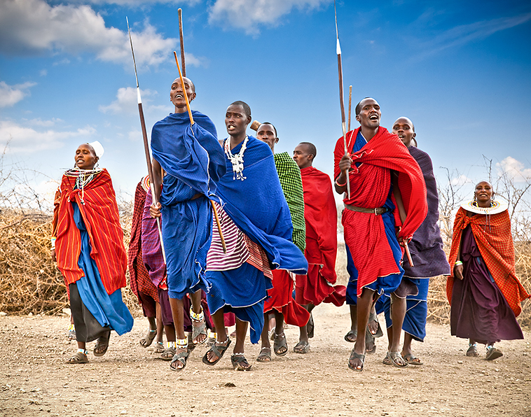
THE MAASAI
The Maasai are pastoral nomads who have actively resisted change, and many still follow the same lifestyle they have pursued for centuries. Their traditional culture centres on their cattle, which, along with their land, are considered sacred. Cows provide many of their needs: milk, blood and meat for their diet, and hides and skins for clothing, although sheep and goats also play an important dietary role, especially during the dry season.
Maasai society is patriarchal and highly decentralised. Maasai boys pass through a number of transitions during their life, the first of which is marked by the circumcision rite. Successive stages include junior warriors, senior warriors, junior elders and senior elders; each level is distinguished by its own unique rights, responsibilities and dress. Junior elders, for example, are expected to marry and settle down sometime between the ages of 30 and 40. Senior elders assume the responsibility of making wise and moderate decisions for the community. The most important group is that of the moran (newly initiated warriors), who are charged with defending the cattle herds.
Maasai women play a markedly subservient role and have no inheritance rights. Polygyny is widespread and marriages are arranged by the elders, without consulting the bride or her mother. Since most women are significantly younger than men at the time of marriage, they often become widows; remarriage is rare.
Crater Highlands
The hauntingly beautiful Crater Highlands is where the Rift Valley really gets interesting. The highlands warp along numerous extinct volcanoes, calderas (collapsed volcanoes) and the dramatic Rift Valley Escarpment on the park’s eastern side. The peaks include Oldeani (3188m), Makarot (Lemagurut; 3107m), Olmoti (3100m), Loolmalasin (3648m), Empakaai (also spelled Embagai; 3262m), Ngorongoro (2400m) and the still-active Ol Doinyo Lengai (2878m). The different peaks were created over millions of years by a series of eruptions connected with the birth of the Great Rift Valley, and the older volcanoes have since collapsed, forming the striking ‘craters’ (really, they’re calderas) that give the range its name.
TREKKING THE CRATER HIGHLANDS
The best way to explore the Crater Highlands is on foot, although because of the logistics and multiple fees involved, trekking here is expensive: from US$350 per person and up (less if you have a large group) for overnight trips. Treks range from short day jaunts to excursions of two weeks or more. For all routes, you’ll need to be accompanied by a guide, and for anything except day hikes, most people use donkeys or vehicle support to carry water and supplies (though vehicles can’t go everywhere the donkeys can).
Nearly all visitors arrange treks through a tour company. Many Arusha-based companies can take you up Ol Doinyo Lengai, just outside the Ngorongoro Conservation Area (NCA) boundaries, as can the accommodation places in Lake Natron or Engaruka.
There are no set routes, and the possibilities are numerous. Good two-day trips include the Ngorongoro Crater rim, Olmoti to Empakaai, and Empakaai to Lake Natron. These three can be strung together into an excellent four-day trip: start at Nainokanoka ranger post to make it three days or extend it one day to climb Ol Doinyo Lengai.
If you base yourself at Ngorongoro Crater or Karatu, there are some good day hikes that let you experience the area on a lower budget, such as climbing Makarot or Oldeani, or walking along the Empakaai or Olmoti craters. Apart from transport costs, these involve only the US$70.80 NCA entry fee and US$23.60-per-group guide fee. Oldeani is the least complicated option, since the climb starts at the Ngorongoro Conservation Area Authority headquarters. From Oldeani, it’s possible to camp and continue on down to Lake Eyasi, where there’s public transport.
1Sights & Activities
![]() oEmpakaai CraterVOLCANO
oEmpakaai CraterVOLCANO
( MAP GOOGLE MAP )
Lake-filled Empakaai Crater, 23km northeast of Olmoti Crater, may not be as famous as Ngorongoro, but many travellers consider it to be its match in beauty. The lake, which draws flamingos and other waterbirds, fills most of the crater floor, which is surrounded by steep-sided, forested cliffs at least 300m high. The view from the crater rim is one of the most appealing in northern Tanzania, but hiking down into the crater is a wonderful experience as well.
The road from Ol Doinyo Lengai runs along part of the eastern crater rim, which varies in altitude from 2700m to 3200m, and a steep, well-kept trail descends from the road through montane forest rich in bird life; also keep an eye out for hyenas, buffaloes, blue monkeys and even elephants. En route to the crater floor, watch for views of the turquoise lake down below and the perfect volcanic cone of Ol Doinyo Lengai away to the northeast. Count on around 30 minutes down to the lakeshore, and an hour for the climb back up. It's possible to circumnavigate the lake on foot, which will take at least four hours.
If you're planning on hiking, you are, in theory, required to pick up an armed ranger (US$23.60) from the ranger post at Nainokanoka (next to Olmoti Crater) en route to Empakaai.
To get here, count on a 90-minute drive from the Lemala ascent-descent road.
EngarukaRUINS
( MAP GOOGLE MAP ; adult/child Tsh10,000/5000)
Halfway to Lake Natron, on the eastern edge of the Ngorongoro Conservation Area, lies this 300- to 500-year-old ruin of a farming town that developed a complex irrigation system with terraced stone housing sites. Although the ruins are historically significant, casual visitors are likely to be more impressed with the up-close views of the escarpment than the vaguely house-shaped piles of rocks.
Archaeologists are unsure of Engaruka's origins, although some speculate that the town was built by ancestors of the Iraqw (Mbulu) people, who once populated the area and now live around Lake Eyasi. Others propose it was the Sonjo, a Bantu-speaking people.
Knowledgeable English-speaking guides (no set prices) for the ruins or other walks in the area, including a one-day climb of nearby Kerimasi, can be found at Engaruka Ruins Campsite, or they can be arranged in advance through the Tanzania Tourist Board Tourist Information Centre in Arusha. It's also worth contacting the Engaruka Cultural Tourism Program (
GOOGLE MAP
; ![]() %0754 507939, 0787 228653; www.tanzaniaculturaltourism.com/engaruka.htm), which arranges visits to Maasai villages and other local attractions, as well as climbs up Kerimasi and Ol Doinyo Lengai.
%0754 507939, 0787 228653; www.tanzaniaculturaltourism.com/engaruka.htm), which arranges visits to Maasai villages and other local attractions, as well as climbs up Kerimasi and Ol Doinyo Lengai.
The ruins are unsigned above the village of Engaruka Juu. Turn west at Engaruka Chini, a smaller village along the Lake Natron road, and follow the rough track 4.5km until you reach Engaruka Juu Primary Boarding School.
Olmoti CraterVOLCANO
( MAP GOOGLE MAP )
Though lacking the drama of Ngorongoro and Empakaai, Olmoti Crater, 13km north of the Lemala ascent-descent road, is worth visiting on your way north into the highlands. It's also the starting point for a two-day trek to Empakaai. Olmoti's crater floor is shallow, haired with grass and crossed by the Munge River. To reach the rim, it's a one-hour return walk from where the 4WD track ends on the crater's eastern side. From here, a short trail leads to the Munge Waterfall.
4Sleeping & Eating
Apart from a few rudimentary campsites out here and options around Lake Natron, there's no formal accommodation in these parts. There are two campsites around the rim of Empakaai Crater and a further 15 out on the western plains. Camping at each costs US$70.80/35.40 per adult/child; reservations should be made through the Ngorongoro Conservation Area Authority as far ahead as possible. There's a very basic guesthouse ( GOOGLE MAP ; Engaruka; s/d with shared bathroom Tsh7500/14,000) in Engaruka. You'll need to carry in your own supplies of food and water, as very little is available in the villages out on the trail.
Engaruka Ruins Campsite (
MAP
GOOGLE MAP
; Engaruka Juu; camping US$10; ![]() p) is dusty but shady, with acceptable ablutions. You can use its tents for free and meals are available on request.
p) is dusty but shady, with acceptable ablutions. You can use its tents for free and meals are available on request.
8Getting There & Away
A daily bus to Arusha (Tsh12,000, four to five hours) via Mto wa Mbu (Tsh5000, 1½ hours) leaves Engaruka at 6am, turning around for the return trip shortly after arrival. There's no public transport between here and Ngorongoro Crater.
Village fees (ie tourist taxes) must be paid at three gates along the way: Engaruka Chini (US$10), 7km before Engaresero (US$10), and just outside Engaresero (US$15). Note that if you're coming from Lake Natron and you're heading for Arusha, you can avoid the fees at Engaruka Chini and the one between Engaruka and Engaresero by taking the graded track that runs east to the Arusha–Namanga Rd soon after leaving Engaresero.
Lake Natron
Shimmering amid the sun-scorched Kenyan border northeast of Ngorongoro Conservation Area, this 58km-long but just 50cm-deep alkaline lake should be on every adventurer’s itinerary. The drives from Mto wa Mbu or the northern Serengeti are remote, with a desolate, other-worldly beauty and an incomparable feeling of space and antiquity. The roads pass through untrammelled Maasai land, with small bomas (fortified compounds) and big mountains often in view in a wild, cauterised landscape. From June to November at the lake itself, upwards of three million flamingos gather – it's one of East Africa's most stirring wildlife spectacles. And close to the southern end of the lake, the views of Ol Doinyo Lengai volcano are splendid.
The base for visits is the small oasis of Engaresero (also spelled Ngare Sero; ‘impermanent water’ in Maasai) on the lake's southwestern shore.
2Activities
Drawing together a host of activities around Engaresero and Lake Natron, the Maasai-run Engaresero Cultural Tourism Program (
MAP
GOOGLE MAP
; ![]() %0784 769795, 027-205 0025; www.engaresero.org) offers guided walking trips to the lake, hot springs, a nearby waterfall or a set of recently discovered 120,000-year-old human footprints preserved in volcanic ash; biking tours; village visits; 'ethno-botanical' tours; and trekking to the summit of Ol Doinyo Lengai volcano (US$60 to US$100). Most tours (except the Ol Doinyo Lengai climb) cost US$25 per person. The program is affiliated (and shares a website and premises) with the Engaresero Tourism Office (
GOOGLE MAP
;
%0784 769795, 027-205 0025; www.engaresero.org) offers guided walking trips to the lake, hot springs, a nearby waterfall or a set of recently discovered 120,000-year-old human footprints preserved in volcanic ash; biking tours; village visits; 'ethno-botanical' tours; and trekking to the summit of Ol Doinyo Lengai volcano (US$60 to US$100). Most tours (except the Ol Doinyo Lengai climb) cost US$25 per person. The program is affiliated (and shares a website and premises) with the Engaresero Tourism Office (
GOOGLE MAP
; ![]() %0784 769795; www.engaresero.org;
%0784 769795; www.engaresero.org; ![]() h6am-6.30pm), located near the southern entrance to town.
h6am-6.30pm), located near the southern entrance to town.
CLIMBING OL DOINYO LENGAI
The northernmost (and youngest) volcano in the Crater Highlands, Ol Doinyo Lengai ( MAP GOOGLE MAP ; www.oldoinyolengai.pbworks.com), ‘Mountain of God’ in the Maasai language, is an almost perfect cone with steep sides rising to a small, flat-topped peak (2878m). It’s still active, last erupting in 2008. At the peak, you can see hot steam vents and growing ash cones in the north crater. Climbing the mountain is possible – at once challenging and extremely beautiful – but it's a serious undertaking: you'll need a guide, stamina and a head for heights.
With a midnight start, a trek from the base village of Engaresero at Lake Natron is possible in one long day. You'll usually be back down by mid-morning. The climb is not for the faint-hearted, but the rewards are considerable: the sunrise views out over Lake Natron, the escarpment and beyond are among the best in Tanzania.
There are, however, some things to take into account when preparing your ascent. It's strongly recommended that you take a helmet – there are often baboons on the higher slopes and they frequently dislodge gravel and sometimes larger stones; other wildlife to watch out for includes leopards and klipspringers. It's also extremely steep near the summit – although it's a trek rather than a technical climb, in places you'll be close to vertical. And throughout the climb, the loose ash along most of the path makes it difficult going when ascending, and it can be an even tougher, often painful, descent.
Climbing Ol Doinyo Lengai costs between US$60 and US$100 per person, depending on how many are in the party. Guides can be arranged through your lodging or through the community-run Engaresero Tourism Office at the southeastern entrance to Engaresero.
4Sleeping & Eating
There are several budget campsites clustered around the southwestern end of the lake, and Engaresero village has a couple of basic grocery shops.
Waterfall CampsiteCAMPGROUND$
( MAP GOOGLE MAP ; camping US$10)
Where the road ends and the walking trail to the waterfall begins, this campground has simple amenities but a nice, shady location. There are no cooking facilities.
Maasai Giraffe Eco LodgeLODGE$$
(
MAP
GOOGLE MAP
; ![]() %0762 922221; www.maasaigiraffe.com; camping US$10, s/d US$84/118;
%0762 922221; www.maasaigiraffe.com; camping US$10, s/d US$84/118; ![]() W)
W)
There's not much shade to be had in this large fenced compound, but the views of Ol Doinyo Lengai volcano are superb. Rooms, in thatched bands, are simple but fine, but you'll want to spend most of your time on the terrace gazing at the mountain. Meals are available and there's a kitchen for self-caterers.
Halisi CampTENTED CAMP$$$
(
MAP
GOOGLE MAP
; ![]() %027-275 4295, 0682 303848; www.halisicamps.com; per person with full board US$450)
%027-275 4295, 0682 303848; www.halisicamps.com; per person with full board US$450)![]() S
S
With safari tents that look as though they could be removed without leaving a trace, Halisi has an appealing bush-camp feel to it without compromising on comfort. There are good views of Ol Doinyo Lengai volcano, and the camp is away from the town and close to the lake; it can become unpleasant when winds blow sand across the plains.
Ngare Sero Lake Natron CampTENTED CAMP$$$
(
MAP
GOOGLE MAP
; www.lake-natron-camp.com; per person full board from US$275; ![]() p)
p)![]() S
S
As close as you can sleep to the lake, Lake Natron Camp is wonderfully sited, with tents just back from the shore. The tents are excellent and often strategically placed around natural plunge pools, and there's a range of activities on offer. The place is at its best when the sun goes down and silence envelopes the lake.
Natron River CampTENTED CAMP$$$
(
GOOGLE MAP
; ![]() %0765 941778; www.wildlandssafaris.com; per person with half board US$250;
%0765 941778; www.wildlandssafaris.com; per person with half board US$250; ![]() p
p![]() W
W![]() s)
s)
A simple but nicely turned-out camp in Engaresero, Natron River Camp has eight safari tents with concrete floors and a pleasant, shady location alongside the riverbed. Tents are a nice mix of comfort and simplicity, while the public areas have a quiet sophistication.
Lake Natron Tented CampTENTED CAMP$$$
(
MAP
GOOGLE MAP
; ![]() %0754 324193; www.moivaro.com; camping US$10, half board s US$140-250, d US$200-350;
%0754 324193; www.moivaro.com; camping US$10, half board s US$140-250, d US$200-350; ![]() p
p![]() s)
s)
At the southern end of Engaresero in a grove of trees, this tented camp is a little rundown and the tents are a tad dated, but it's comfortable enough. There’s a large and sometimes busy campground with good facilities next door. Strangely, given the proximity, you'll need to step beyond the property for a view of Ol Doinyo Lengai volcano.
Lengai Safari LodgeLODGE$$$
(
MAP
GOOGLE MAP
; ![]() %0754 550542, 0768 210091; www.lengaisafarilodge.com; camping US$10, per person with full board US$120;
%0754 550542, 0768 210091; www.lengaisafarilodge.com; camping US$10, per person with full board US$120; ![]() p
p![]() W
W![]() s)
s)
A few kilometres south of town along the escarpment, this lodge offers unbeatable views of Ol Doinyo Lengai, and good ones of the lake too, including from some rooms. The newly constructed rooms and tents are comfortable rather than luxurious; more were being built at the time of research. It's easily the best location of any of the area's accommodation options.
8Getting There & Away
The road from Mto wa Mbu is partly sandy and partly rocky. During the rainy season you may have to wait a few hours at some of the seasonal rivers before you’re able to cross. The road past the lake to Loliondo and into the Serengeti is in better shape because it’s used far less. Those continuing this way should carry extra supplies of petrol, since the last proper station is in Mto wa Mbu, though some people sell (expensive) petrol from their homes.
A rickety, crowded bus runs between Arusha and Loliondo, stopping in Engaresero (Tsh27,000, nine hours). It departs Arusha at 6.30am on Sunday and passes back through Engaresero on Thursday around 10am. Trucks (and sometimes 4WDs operating as public transport) run between Mto wa Mbu and Engaresero pretty much daily, but it’s not unheard of to have to wait two days to find a ride, especially in the rainy season.
If you're driving from Ngorongoro, you'll need to set out early and count on an entire day to reach Lake Natron – ask at the Ngorongoro Conservation Area Authority headquarters and Nainokanoka ranger post about track conditions.
INDEPENDENT TRAVEL TO LAKE NATRON
Independent exploration of the southern reaches of the lake isn't really encouraged: it's the community's way of ensuring that they receive some benefits from travellers passing through their town. This means that, although there's nothing to stop you from driving down to the lakeshore, you can expect someone from the local community-run tourism operative to turn up at your accommodation and ask politely for payment. It's recommended that you pay or, better still, contact them in advance so that you can take a local guide with you to make the most of your visit.
Oldupai Gorge & Western Ngorongoro
Standing near the western rim of the Ngorongoro Crater and looking out towards the west is like contemplating eternity. Table-flat plains stretch towards the Serengeti, with the forbidding Gol Mountains away to the north. Within this landscape, Maasai eke out an existence from the dust of plains where wildlife is wary but present nonetheless – wildebeest, eland, topi, gazelle and zebra herds come here between January and March on the southern stretch of their migration.
But there's more to these plains than meets the eye. Slicing its way through up to 90m of rock and two million years of history, Oldupai (Olduvai) Gorge on the plains northwest of Ngorongoro Crater is a dusty, 48km-long ravine sometimes referred to as the cradle of humankind.
Its unique geological history provides remarkable documentation of ancient life, allowing us to look back to the days of our earliest ancestors.
There's nowhere to sleep at Oldupai Gorge, with the nearest places a few hours' drive away in Ngorongoro and the Serengeti – everyone who visits does so en route between the two. Safari lodges in Ngorongoro and the Serengeti will pack a lunchbox for those departing – whether you pay extra for one will depend on how many meals you've had at the lodge/camp in question.
Oldupai MuseumMUSEUM
(
MAP
GOOGLE MAP
; adult/child US$20/10; ![]() h7.30am-4.30pm)
h7.30am-4.30pm)
The small Oldupai Museum on the rim of Oldupai Gorge stands on one of the most significant archaeological sites on earth. It was here in 1959 that Mary Leakey discovered a 1.8-million-year-old ape-like skull from an early hominin (human-like being) now known as Australopithecus boisei. This discovery, along with that of fossils of over 60 early hominids (including Homo habilis and Homo erectus) forever changed the way we understood the dawn of human history. Sadly, the museum is a work in progress.
An EU-funded museum has been under construction at the site for years, but work seems to have stalled – 2018 is the latest official estimate of when the new museum will open. Despite this, admission fees have risen massively in recent years, prompting some safari companies to encourage their guests to boycott the museum until the new museum is completed. Don't join the boycott, though: admission is indeed overpriced for what you get, but the site is still hugely significant and, unless you're likely to have the chance to return, it's a must-see.
In its unrenovated form, the small, two-room museum documents the foundation of the gorge, fossil finds and the legacy of Mary Leakey and her husband, Louis. One room is dedicated to Oldupai, the other to Laetoli. It's a fascinating collection, if poorly presented. You can then walk (or drive) into the gorge (where a small stone signpost marks the place where the fossils were discovered). You can also head out to the shifting sands, a 9m-high, 100m-long black dune of volcanic ash that has blown across the plain from Ol Doinyo Lengai. If you wish to take a guide it will, naturally, cost extra.
The turn-off to the museum is 27km northwest of Ngorongoro Crater's Seneto descent road, and from the turn-off it's a further 5.5km along a rutted track to the museum.
OFF THE BEATEN TRACK
LAETOLI & THE GOL MOUNTAINS
About 45km south of Oldupai (Olduvai) Gorge at remote Laetoli (
GOOGLE MAP
; adult/child US$23.60/11.80; ![]() h7.30am-4.30pm) is a 27m-long trail of 3.7-million-year-old hominid footprints, probably made by Australopithecus afarensis. Discovered by Mary Leakey's team in 1976 and excavated two years later, it's an extraordinarily evocative and remote site. An EU-funded museum (still under construction) is planned, but there's a small temporary museum on the site, with only copies of the prints currently visible. Cast copies of the prints are in Oldupai Museum.
h7.30am-4.30pm) is a 27m-long trail of 3.7-million-year-old hominid footprints, probably made by Australopithecus afarensis. Discovered by Mary Leakey's team in 1976 and excavated two years later, it's an extraordinarily evocative and remote site. An EU-funded museum (still under construction) is planned, but there's a small temporary museum on the site, with only copies of the prints currently visible. Cast copies of the prints are in Oldupai Museum.
An extremely rough, 4WD-only track connects Oldupai Museum with Laetoli via Noorkisaruni Kopje and Endulen. A far better road runs to Endulen from Kimba on the Ngorongoro Crater rim along the southern side of Makarot. Via either route, Laetoli lies 9km from Endulen.
Some places are so far off well-travelled routes that there are no tracks other than those left by wildlife and traditional herders. The remote and rarely visited Gol Mountains ( MAP GOOGLE MAP ) area, northwest of Ngorongoro but still within the boundaries of the Ngorongoro Conservation Area, is just such a place. This remains one of the most traditional corners of Tanzania, home to Maasai who still kill lions as their rite of passage into warriorhood, and who still live outside cash society.
Travelling out here is a major, multiday undertaking that is best organised through a professional Arusha-based safari company.
8Getting There & Away
There's no public transport to the site – indeed, you'll often see locals hitchhiking in the area due to the dearth of reliable transport. The gorge is 27km from Ngorongoro Crater's Seneto descent road and 141km from the Serengeti.
Serengeti National Park
Few people forget their first encounter with the Serengeti (
MAP
GOOGLE MAP
; ![]() %028-262 1515, 0767 536125, 0689 062243; www.tanzaniaparks.go.tz; adult/child US$70.80/23.60;
%028-262 1515, 0767 536125, 0689 062243; www.tanzaniaparks.go.tz; adult/child US$70.80/23.60; ![]() h6am-6pm). Perhaps it's the view from Naabi Hill at the park's entrance, from where the grasslands appear to stretch to the ends of the earth. Or maybe it's a coalition of lions stalking across open plains, their manes catching the breeze. Or it could be wildebeest and zebra migrating in their millions, following the ancient rhythm of Africa's seasons. Whatever it is, welcome to one of the greatest wildlife-watching destinations on earth.
h6am-6pm). Perhaps it's the view from Naabi Hill at the park's entrance, from where the grasslands appear to stretch to the ends of the earth. Or maybe it's a coalition of lions stalking across open plains, their manes catching the breeze. Or it could be wildebeest and zebra migrating in their millions, following the ancient rhythm of Africa's seasons. Whatever it is, welcome to one of the greatest wildlife-watching destinations on earth.
SERENGETI NATIONAL PARK
Why Go Wildebeest migration; excellent chance of seeing predators; overall high wildlife density; fine birdwatching; stunning savannah scenery.
When to Go Year-round; July and August for wildebeest migration across the Mara River; February for wildebeest calving; February–May for birdwatching.
Practicalities Drive in from Arusha or Mwanza, or fly in. To avoid congestion, spend some time outside the central Serengeti/Seronera area. Entrance fees can be paid in cash or by credit card at the Naabi Hill, Ndabaka and Klein's gates.
Budget Tips Catch the Arusha–Musoma bus and hope to see something along the way; stay in the public campsites; book a budget safari from Arusha.

Serengeti National Park
1Top Sights
1Sights
2Activities, Courses & Tours
4Sleeping
7Shopping
1Sights
On the vast plains of the Serengeti, nature’s mystery, power and beauty surround you as they do in few other places. It’s here that one of earth’s most impressive natural cycles has played itself out for aeons as hundreds of thousands of hoofed animals, driven by primeval rhythms of survival, move constantly in search of fresh grasslands. The most famous, and numerous, are the wildebeest (of which there are some 1.5 million) and their annual migration is one of the Serengeti’s biggest draws. Besides the migrating wildebeest, there are also resident populations in the park and you’ll see these smaller but still impressive herds year-round. In February more than 8000 wildebeest calves are born per day, although about 40% of these die before reaching four months old. A few black rhinos in the Moru Kopjes area give you a chance to glimpse all of the Big Five (lion, elephant, rhino, leopard and buffalo), although the rhinos are very rarely seen.
The 14,763-sq-km national park is also renowned for its predators, especially its lions. Hunting alongside them are cheetahs, leopards, hyenas, jackals and more. These feast on zebras, giraffes, buffaloes, Thomson’s and Grant’s gazelles, topis, elands, hartebeests, impalas, klipspringers, duikers and so many more. The Serengeti is an incredible birdwatching destination also, with over 500 species.
Entry fees are valid for 24 hours, with a single entry only.
THE SERENGETI LION PROJECT
The Serengeti Lion Project is widely considered to be the second-longest-running continuous scientific study of a species in Africa; Jane Goodall's study of chimpanzees in Gombe Stream National Park is the only study to have lasted longer.
And it is from the Serengeti Lion Project that we have learned much of what we know about lions – why they form prides, why they roar, and so on. It all began back in 1966 with Dr George Schaller, now one of the world's most respected wildlife scientists, who wrote what remains the seminal text on lion behaviour: The Serengeti Lion.
All the subsequent heads of the project have written books, and it is one of these, Craig Packer's Lions in the Balance, that almost sounded the project's death knell. Packer's ongoing criticism of the relationship between the Tanzanian government and the trophy-hunting industry would ultimately lead to Packer's expulsion from the country. For three years, the Serengeti Lion Project barely functioned, and there were fears that the project would fall into the wrong hands or perhaps even come under the aegis of the trophy-hunting industry itself. In the end, in June 2017 responsibility for the project was handed to respected lion scientists Bernard Kissui and Mike Anderson. It now appears likely that the project will continue, at least for the foreseeable future.
The heads of the project and the books they wrote about their experiences are as follows:
George Schaller (1966–69) The Serengeti Lion (1972)
Brian Bertram (1969–74) Pride of Lions (1978)
Jeannette Hanby and David Bygott (1974–78) Lion's Share: The Story of a Serengeti Pride (1982)
Craig Packer (1978–2014) Into Africa (1994) and Lions in the Balance: Man-Eaters, Manes, and Men With Guns (2015)
Although not specifically relating to lions, Anthony Sinclair's Serengeti Story: Life and Science in the World's Greatest Wildlife Region (2012) is also worth tracking down.
Seronera & the South
Visiting or staying in Seronera, in the heart of the park and readily accessed from both Arusha and Mwanza, involves something of a trade-off. On the one hand, this is wildlife central, with sightings of lions (around 300 live in the park's south alone), leopards and cheetahs almost guaranteed. On the other, such abundance comes at a price: you may find yourself among a pack of 20 vehicles jostling in unlovely fashion to look at a single lion.
Southeast of Seronera is a prime base for wildlife watching during the December–April wet season, when it’s full of wildebeest. This corner of the Serengeti also has year-round water and a good mix of habitats. Most Seronera safaris concentrate on the Seronera River and with good reason: the trees along the riverbank are home to one of the world's densest concentrations of leopards, while lion sightings are common. Lion sightings are also probable around the Maasai Kopjes, Simba Kopjes, Moru Kopjes, Gol Kopjes and Barafu Kopjes, and around Makoma Hill. The vast plains south of the Seronera River, often known simply as the Serengeti Plains, are particularly good for cheetahs. The plains that rise towards the Kamuyo Hills west of the Seronera River (draw a line west of the Seronera Wildlife Lodge) are particularly good for elephants, spotted hyenas and cheetahs.
THE SERENGETI KOPJES
Some of the Serengeti's most distinctive land forms are its kopjes: strange bouldered hills in a landscape where the horizon seems to continue to infinity. They're also important wildlife refuges, sheltering leopards, lion prides and a host of reptile species. But how were they formed?
Kopjes began life as bubbles of molten rock that, billions of years ago, forced themselves up into the layers that form the substrata of the earth. Around 500 million years ago, shifts in the surface of the earth forced up low hills across the Serengeti; over the millions of years that followed, these hills slowly eroded, leaving behind only the kopjes, which are made of hard, crystalline rock. In other words, kopjes are the summits of ancient mountains that long ago eroded away. The most obvious example of a mountain at an earlier stage of erosion is Naabi Hill.
And it's not just erosion that plays a role in shaping the kopjes. The eruption of the volcanoes of the Crater Highlands over the past five million years blanketed the land here in ash, creating the Serengeti's plains and further submerging the hills that the kopjes once crowned.
Even now, the process of geological change continues as extremes of climate stretch and shrink the outer layers of the rocks that form the kopjes, causing pieces to break off and changing the shape of what remains.
Grumeti & the Western Corridor
The herd migration usually passes through the Serengeti's Western Corridor, and the contiguous Grumeti Game Reserve, sometime between late May and early July. The crossing of the Grumeti River may not rival that of the Mara River further north – there are few vantage points and the river is much narrower and easy to cross here – but it's still one of the migration's great spectacles.
During the rest of the year, lions and leopards are prevalent along the forest-fringed Grumeti River, which also has hippos and giant crocodiles. North of the river, try the Kitunge Hills, Ruana Plain and just about anywhere in the Grumeti Game Reserve, while south of the river concentrate on the Ndabaka Plains, Simiti Hills, Dutwa Plains, Varicho Hills and down to the Mbalageti River.
These western reaches of the Serengeti are most easily reached from Mwanza. If driving from the Ndabaka gate, count on at least half a day to reach Seronera, at the centre of the park, and more if you stop along the way.
Central Plains
Except when the herd migration passes through (usually in November and December), this is not the Serengeti's most prolific corner when it comes to wildlife. Its mix of light woodland, acacia thorn and open plains can also be dispiriting during the heat of the day, which, given the lack of lodges in the area, is when most people pass through as they travel between the north and south of the Serengeti. This is also one area of the park experiencing a growing problem with local communities encroaching into the park, with a concomitant effect on wildlife numbers. In other words, you're more likely to visit here on your way elsewhere, rather than for its own sake.
Even so, there are some fine vistas along this north–south route through the park, not to mention a blissfully remote feel to much of the countryside around here. If nothing else, the park's central area is worth passing through to gain a deeper appreciation of just how vast the Serengeti's ecosystem really is.
WORTH A TRIP
SERENGETI TO LAKE NATRON
If you're in the northern Serengeti, to really get off the beaten track – not to mention avoid the long and expensive route back through the Serengeti and Ngorongoro Conservation Area – it's possible to drive from Klein's gate all the way to Lake Natron in around five hours. Although the road is unpaved all the way, it's generally in good condition and passable in most vehicles, except after rain.
After leaving Klein's gate, drive 13km to Ololosokwan, where you should stop to buy honey from Maasai Honey (
MAP
GOOGLE MAP
; ![]() %0767 889684, 0684 155793; www.maasaihoney.org; Ololosokwan;
%0767 889684, 0684 155793; www.maasaihoney.org; Ololosokwan; ![]() h9am-4pm Mon-Fri, 1-5pm Sun). The road roughly shadows the Kenyan border and passes through the barren, stony country that forms part of the Loliondo Game Controlled Area. After 10km, you'll reach Soitsambu; at the time of research, the roads at the western approach to Soitsambu were some of the worst along the whole route. From Soitsambu, the road continues southeast and then south to the large town of Waso. Some 17km south of Waso, take the road branch that heads left (southeast); if you take the right branch, you'll reach the town of Loliondo and, eventually, the Ngorongoro Conservation Area, close to Oldupai (Olduvai) Gorge.
h9am-4pm Mon-Fri, 1-5pm Sun). The road roughly shadows the Kenyan border and passes through the barren, stony country that forms part of the Loliondo Game Controlled Area. After 10km, you'll reach Soitsambu; at the time of research, the roads at the western approach to Soitsambu were some of the worst along the whole route. From Soitsambu, the road continues southeast and then south to the large town of Waso. Some 17km south of Waso, take the road branch that heads left (southeast); if you take the right branch, you'll reach the town of Loliondo and, eventually, the Ngorongoro Conservation Area, close to Oldupai (Olduvai) Gorge.
After the road branches, you begin the long, slow descent from the Rift Valley Escarpment to the valley floor. Watch for views of Gelai (2941m) and, later, Lake Natron and Ol Doinyo Lengai (2962m) before you make the final descent. It's 81km from the turn-off to the village of Engaresero, the town with most of the tourist infrastructure near Lake Natron's southern shore, with the last 20km or so along the Rift Valley floor and the lakeshore.
Mara River & the North
Compared with Seronera and the south, the Serengeti's north receives relatively few visitors. It begins with acacia woodlands, where elephants congregate in the dry season, then north of Lobo stretches into vast open plains. The herd migration usually passes through the western side during August and September and comes down the eastern flank in November.
North of the Grumeti River, the Bologonya Hills, Bologonya River, Nyamalumbwa Hills and Mara River are all outstanding. If you're driving from the Mara River to Seronera, allow the best part of a day.
Outside the park, the little-visited Ikorongo Game Reserve, which shadows the northwestern boundary of the park, is wild and worth visiting. Away to the east, the Loliondo Game Controlled Area, just outside the Serengeti’s northeastern boundary, offers the chance for Maasai cultural activities, walking safaris, night drives and off-road drives. A loop east across Loliondo and then down through to Lake Natron and the Crater Highlands or Ngorongoro is a wonderfully remote alternative to driving back down through the park.
2Activities
Wildlife drives are the main activity here – some would say they're the reason to come to the Serengeti in the first place. Walking safaris are a relatively new activity here, but with luck they'll catch on.
Wildlife Drives
A wildlife drive in the Serengeti – whether self-drive, as part of an organised safari or as operated by your Serengeti lodge – is one of the most enjoyable things you can do in Africa. Exploring the Serengeti's four major areas (Seronera and the South, Grumeti and the Western Corridor, Central Serengeti and Northern Serengeti) requires careful planning; understanding what each area has to offer and at what time of year will determine how you experience this wonderful place.
Walking Safaris
A new development in the Serengeti is the introduction of walking safaris. Led by Wayo Africa, multiday camping trips are available in the Moru Kopjes, at Kogatende (by the Mara River) and in other areas of the park, and they can be as relaxing or as adventurous as clients prefer. Prices start at US$1650 per person per day for a two-day, two-night expedition; expeditions can also be combined with other safaris.
Balloon Safaris
Serengeti Balloon SafarisSAFARI
(
MAP
GOOGLE MAP
; ![]() %0784 308494, 027-254 8077; www.balloonsafaris.com; per person incl park ballooning fee US$546.20)
%0784 308494, 027-254 8077; www.balloonsafaris.com; per person incl park ballooning fee US$546.20)
There’s no better way to see the Serengeti than by spending an hour floating over the plains at dawn, followed by an ‘Out of Africa’ full English breakfast in the bush under an acacia tree. You'll rise to 1000m for a vast view, then drop to treetop level. To be sure of a spot, reserve well in advance.
FOLLOW THE MIGRATION
You've come to see the wildebeest migration, but how can you be sure to be there when it happens? The short answer is that you can't, and making the decision of when to go where always involves some element of risk. What follows is a general overview of what usually happens, but it's a guide only:
January–March During the rains, the wildebeest are widely scattered over the southern and southwestern section of the Serengeti and the western side of Ngorongoro Conservation Area.
April Most streams dry out quickly when the rains cease, nudging the wildebeest to concentrate on the few remaining green areas, and to form thousands-strong herds that begin to migrate northwest in search of food.
May–early July In early May, the herds cross northwest towards the Western Corridor, and the crossing of the crocodile-filled Grumeti River usually takes place between late May and early July, and lasts only about a week.
Mid-July–August By the second half of July, the herds are moving north and northwest into the northern Serengeti and Kenya's Masai Mara. As part of this northwards push, they make an even more incredible crossing of the Mara River.
September & October In early September, the last stragglers leave the Serengeti and most will remain in the Masai Mara throughout October.
November & December The herds usually begin moving south again in November in anticipation of the rains, crossing down through the heart of the Serengeti and to the south in December.
Exceptions to these general guidelines are common, and it's becoming increasingly rare for the herd to remain in one group. In 2017, for example, the herds were still in the far south well into April. When they did finally move north, one group headed all the way up to Kenya and were already crossing the Sand River into Kenya's Masai Mara in early June. The remainder followed a more traditional path into the Western Corridor, but even this group was beginning to gather in the Serengeti's north by late June.
4Sleeping & Eating
There are nine public campsites (US$35.40/5.90 per adult/child) in the Serengeti: six around Seronera, one at Lobo and one each at Ndabaka and Fort Ikoma gates. All have flush toilets, and two (Pimbi and Nyani, both in the Seronera area) have kitchens, showers and solar lighting.
There are dozens of special campsites (US$59/11.80 per adult/child) scattered throughout the Serengeti, although many are occupied on a semi-permanent basis by mobile or more sedentary camps. The others should be booked well in advance through Tanapa at serengeti@tanzaniaparks.go.tz.
If you're camping and don’t want to cook for yourself, there are two local restaurants (meals Tsh6000 to Tsh15,000) and three little grocery shops at national-park staff quarters. Anyone can also dine at the park's Twiga Resthouse. Self-caterers should stock up in Arusha or Mwanza.
Seronera & the South
Twiga ResthouseGUESTHOUSE$$
(
MAP
GOOGLE MAP
; ![]() %028-262 1510; www.tanzaniaparks.go.tz; Central Serengeti; r per person US$35.40;
%028-262 1510; www.tanzaniaparks.go.tz; Central Serengeti; r per person US$35.40; ![]() p)
p)
Twiga offers simple but decent rooms with electricity and hot showers, and satellite TV in the lounge. Guests can use the kitchen, or meals can be cooked for you if you order way in advance. There’s a well-stocked little bar and a bonfire at night.
Dunia CampTENTED CAMP$$$
(
MAP
GOOGLE MAP
; www.asiliaafrica.com; Southern Serengeti; per person with full board Jan, Feb & Jun-Oct US$834, rest of year US$369-699; ![]() p)
p)
Unlike the large, impersonal lodges that predominate in Seronera, this intimate eight-tent camp has a classic safari ambience. Comfortable, with great service, it’s essentially a mobile camp that stays put. Set below the Nyaraboro Hills, but at the end of a long rise, Dunia has both distant views and up-close encounters with wildlife. Highly recommended if you want a bush atmosphere.
Serengeti Sopa LodgeLODGE$$$
(
MAP
GOOGLE MAP
; ![]() %027-250 0630; www.sopalodges.com; Southern Serengeti; s/d/tr with full board Jan, Feb & Jun-Oct US$385/680/867, rest of year rates vary;
%027-250 0630; www.sopalodges.com; Southern Serengeti; s/d/tr with full board Jan, Feb & Jun-Oct US$385/680/867, rest of year rates vary; ![]() p
p![]() i
i![]() W
W![]() s)
s)
Though architecturally unappealing and with less inspired rooms than you might expect for the price, the Sopa Lodge is removed from the Seronera scrum in a valley of yellow acacia trees. The 73 rooms are spacious, with small sitting rooms and two double beds, and some even have views. It’s 45 minutes south of Seronera.
Serengeti Serena Safari LodgeLODGE$$$
(
MAP
GOOGLE MAP
; ![]() %027-254 5555; www.serenahotels.com; Central Serengeti; s/d with full board Jan, Feb & Jul-Oct US$426/711, rest of year rates vary;
%027-254 5555; www.serenahotels.com; Central Serengeti; s/d with full board Jan, Feb & Jul-Oct US$426/711, rest of year rates vary; ![]() p
p![]() i
i![]() W
W![]() s)
s)
Serena’s Maasai-style bungalows boast well-appointed rooms with lovely furnishings and views. The top-floor rooms are best. Guides lead short nature walks, and the Maasai stage an evening dance show. It's a good location for those who want to explore several parts of the park but not switch accommodation, and the hilltop site offers fine views when the herd migration's in town.
Grumeti & the Western Corridor
Serengeti Stop-OverCAMPGROUND$
(
MAP
GOOGLE MAP
; ![]() %0757 327294, 028-262 2273; www.serengetistopoverlodge.com; Western Serengeti; camping US$10, s/d US$55/80;
%0757 327294, 028-262 2273; www.serengetistopoverlodge.com; Western Serengeti; camping US$10, s/d US$55/80; ![]() p)
p)
Just 1km from Ndabaka gate along the Mwanza–Musoma road, this sociable place has camping with hot showers and a cooking area, plus 14 simple rondavels and a restaurant-bar. Safari-vehicle rental is available with notice and Serengeti day trips are feasible. It also offers trips on Lake Victoria with local fishers, visits to a traditional healer and other Sukuma cultural excursions.
Balili Mountain ResortTENTED CAMP$$
(
MAP
GOOGLE MAP
; ![]() %0754 710113, 0764 824814; www.bmr.co.tz; Western Serengeti; camping with own/hired tents US$15/20, s/d/tr US$50/80/105, day entry US$5;
%0754 710113, 0764 824814; www.bmr.co.tz; Western Serengeti; camping with own/hired tents US$15/20, s/d/tr US$50/80/105, day entry US$5; ![]() p)
p)
It's neither a mountain nor a resort, but 'no-frills tented lodge on a big rocky hill' doesn’t have the same ring to it. It’s perfectly comfortable, but Balili's main draws are the views of Lake Victoria and the Serengeti. It’s up above Bunda, north of Ndabaka gate, reached by a roller-coaster of a road.
![]() oGrumeti Serengeti Tented CampTENTED CAMP$$$
oGrumeti Serengeti Tented CampTENTED CAMP$$$
(
MAP
GOOGLE MAP
; ![]() %028-262 1267; www.andbeyond.com; Western Serengeti; per person with full board & incl all activities US$740-1340;
%028-262 1267; www.andbeyond.com; Western Serengeti; per person with full board & incl all activities US$740-1340; ![]() hclosed Apr;
hclosed Apr; ![]() p
p![]() W
W![]() s)
s)
This is one of the best and most luxurious camps in the Serengeti. It mixes its wild location with chic pan-Africa decor and the 10 tents are superluxe. Only three tents have unobstructed views of the Kanyanja River, a prime spot during the herd migration; at other times watch hippos while you lounge in the swimming pool.
Sasakwa LodgeLODGE$$$
(
MAP
GOOGLE MAP
; www.singita.com; Western Serengeti; r per person with full board & incl all activities US$1995; ![]() p
p![]() W
W![]() s)
s)![]() S
S
Sasakwa is one of three exclusive lodges in a private concession in the Grumeti Game Reserve. In addition to its tourism focus, conservation dominates much of what the lodge does, from running a private anti-poaching unit to facilitating the reintroduction of the black rhino to the Serengeti's Western Corridor. Rooms are all about old-world elegance. Horseback rides are available.
Kirawira CampTENTED CAMP$$$
(
MAP
GOOGLE MAP
; ![]() %027-254 5555; www.serenahotels.com; Western Serengeti; s/d with full board Jul-Oct US$636/916, rest of year rates vary;
%027-254 5555; www.serenahotels.com; Western Serengeti; s/d with full board Jul-Oct US$636/916, rest of year rates vary; ![]() p
p![]() i
i![]() W
W![]() s)
s)
A rare foray by Serena into the world of tented camps, Kirawira makes you wonder why it doesn't do it more often. The camp, ringing a low hill, works a colonial theme with plenty of antiques and polished-wood floors. The tents have big porches and very un-tent-like bathrooms. Guests rave about the food.
Ikoma Tented CampTENTED CAMP$$$
(
MAP
GOOGLE MAP
; ![]() %0754 324193, 027-250 6315; www.moivaro.com; Western Serengeti; s/d with full board from US$230/345;
%0754 324193, 027-250 6315; www.moivaro.com; Western Serengeti; s/d with full board from US$230/345; ![]() p)
p)
Just outside Fort Ikoma gate and handy for just about anywhere in the park, this relatively simple tented camp combines closeness to the local community with excellent prices and high levels of comfort.
Robanda Safari CampTENTED CAMP$$$
(
MAP
GOOGLE MAP
; ![]() %027-250 6315; www.moivaro.com; Western Serengeti; s/d with full board from US$230/345;
%027-250 6315; www.moivaro.com; Western Serengeti; s/d with full board from US$230/345; ![]() p)
p)
This refreshingly small budget (by Serengeti standards) camp on the plains near Robanda village just outside Fort Ikoma gate has seven no-frills tents covered by a thatched roof. You can do guided walks, and night drives if you have your own vehicle.
SERENGETI: BATTLES ON THE FRINGE
For a number of years the Serengeti authorities have been struggling to protect the park's boundaries from encroachment by Maasai herders and their cattle, particularly along the Serengeti's eastern border. But it's a movement the other way by park authorities and government agents that may prove to be a much bigger flashpoint.
Since at least 2009, and after a similar failed effort caused a minor international outcry around Lake Eyasi, the Tanzanian government has been seeking to set aside land for foreign hunters in an area known as the Loliondo Game Controlled Area, just outside the eastern border of the northern Serengeti. More specifically, the government has sought to create a 1500-sq-km wildlife corridor for the exclusive use of a Dubai-based company that sells trophy-hunting packages for wealthy tourists from the United Arab Emirates. The plan would displace an estimated 30,000 Maasai and would restrict access to dry-season grazing lands for local communities.
The dispute took a nasty turn in August 2017 when park authorities burned more than 100 Maasai huts, leaving many homeless and at least one protester critically injured. Food was destroyed and livestock killed. It all took place close to Ololosokwan, a small village not far from the Serengeti's Klein's gate; Ololosokwan lies along the popular tourist route between the Serengeti and Lake Natron.
The escalation occurred despite a promise in 2014 by then-president Jakaya Kikwete, responding to a two-million-signature petition against the trophy-hunting corridor, that the government had no plans 'to evict the Maasai from their ancestral lands'. Earlier in 2017, the Tanzanian government commissioned a report on the dispute, although the findings were yet to be made public at the time of writing.
Mara River & the North
![]() oSerengeti Bushtops CampTENTED CAMP$$$
oSerengeti Bushtops CampTENTED CAMP$$$
(
MAP
GOOGLE MAP
; www.bushtopscamps.com; Northern Serengeti; s/d with full board & incl all activities US$1250/1800; ![]() p
p![]() i
i![]() W
W![]() s)
s)
In a remote corner of the northern Serengeti, close to the boundary with the Ikorongo Game Reserve, this remarkable camp has large permanent tents with expansive wooden floors, decks with a spa bath, perfectly placed sofas and fabulous views. Many Serengeti lodges are luxurious, but this place is simply magnificent. The food is similarly excellent.
![]() oLamai SerengetiLODGE$$$
oLamai SerengetiLODGE$$$
(
MAP
GOOGLE MAP
; ![]() %0784 208343; www.nomad-tanzania.com; Northern Serengeti; s/d with full board & incl all activities US$1570/2150;
%0784 208343; www.nomad-tanzania.com; Northern Serengeti; s/d with full board & incl all activities US$1570/2150; ![]() hJun–mid-Mar;
hJun–mid-Mar; ![]() p
p![]() W
W![]() s)
s)
Built on a kopje near the Mara River in the far-northern Serengeti, Lamai blends into its surroundings so well it’s nearly invisible. There are two lodges, one with eight rooms and another with four, each with its own dining areas and swimming pools. All rooms have African-themed decor and soothing earth tones and are open-fronted, with great views.
![]() oSerengeti Migration CampTENTED CAMP$$$
oSerengeti Migration CampTENTED CAMP$$$
(
MAP
GOOGLE MAP
; ![]() %027-250 0630; www.elewanacollection.com; Northern Serengeti; s/d with full board Jul-Oct US$1268/1690, rest of year rates vary;
%027-250 0630; www.elewanacollection.com; Northern Serengeti; s/d with full board Jul-Oct US$1268/1690, rest of year rates vary; ![]() p
p![]() W
W![]() s)
s)
One of the most highly regarded places in the Serengeti, this camp has 20 large, stunning tents with decks, set around a kopje by the Grumeti River where it passes through the north (not the Western Corridor). A tent's immersion in its surroundings is perfectly blended with the luxury of permanence here. You'll have front-row seats when the herd migration passes through.
Klein’s CampLODGE$$$
(
MAP
GOOGLE MAP
; ![]() %028-262 1267; www.andbeyond.com; Northern Serengeti; per person with full board & incl all activities US$840-1340;
%028-262 1267; www.andbeyond.com; Northern Serengeti; per person with full board & incl all activities US$840-1340; ![]() p
p![]() W
W![]() s)
s)
This classic Serengeti lodge is exclusive and strikingly situated (the views are awesome) on a private concession just outside the northeastern park boundary. There are 10 luxurious stone-and-thatch cottages, and the chance to enjoy bushwalks, night wildlife drives or a relaxing massage.
Mobile Camps
Mobile camps are a great idea, but the name's somewhat misleading. They do move (though never when guests are in residence), following the wildebeest migration so as to try to be always in good wildlife-watching territory. But with all the amenities people expect on a luxury safari, relocating is a huge chore and most camps only move two or three times a year.
![]() oWayo Green CampTENTED CAMP$$$
oWayo Green CampTENTED CAMP$$$
(
MAP
GOOGLE MAP
; ![]() %0784 203000; www.wayoafrica.com; Northern Serengeti; per person with full board from US$300-350)
%0784 203000; www.wayoafrica.com; Northern Serengeti; per person with full board from US$300-350)![]() S
S
These ‘private mobile camps’ combine the best aspects of tented camps and budget camping safaris and are the best way to get a deep bush experience in the Serengeti. They use 3m-by-3m dome tents and actual mattresses (off the ground), and move from site to site every couple of days, usually sticking to the Serengeti's north.
![]() oOlakira CampTENTED CAMP$$$
oOlakira CampTENTED CAMP$$$
(
MAP
GOOGLE MAP
; ![]() %0736 500156; www.asiliaafrica.com; Northern Serengeti; per person with full board & incl all activities Jul & Aug US$929, rest of year rates vary;
%0736 500156; www.asiliaafrica.com; Northern Serengeti; per person with full board & incl all activities Jul & Aug US$929, rest of year rates vary; ![]() hJun–mid-Nov;
hJun–mid-Nov; ![]() p
p![]() W)
W)![]() S
S
Olakira's northern location is one of the Serengeti's finest, with long-distance views down towards Mara River crossing 8, 500m away – one of the busiest during the herd migration – and close to the lively junction between the Mara and Bologonya Rivers. The nine tents are large and beautifully set up and the whole place runs on solar power.
A match for many of the more permanent camps dotted around the Serengeti, Olakira moves between the far south (roughly December to March) and far north of the park.
Ubuntu Tented CampTENTED CAMP$$$
(www.asiliaafrica.com; per person with full board & incl all activities US$369-784)
This tented camp moves twice a year but feels as comfortable and permanent as any of the year-round camps. With just seven tents, all nicely spaced, there's a feeling of intimacy that you just don't get elsewhere, helped by a friendly staff that has worked together as a team for a while.
Lemala SerengetiTENTED CAMP$$$
(www.lemalacamp.com; s/d with full board & incl all activities US$1110/1700)
Another leader in mobile-camp comforts in the Serengeti, Lemala has a camp in Ndutu from December to March and one close to the Mara River from July to October. Its formula is simple and compelling – make the camps look as permanent as possible, but with the flexibility to move them when the time is right. Expect luxury and high service standards.
Serengeti Safari CampTENTED CAMP$$$
(![]() %0784 208343; www.nomad-tanzania.com; s/d with full board & incl all activities US$1150/1600)
%0784 208343; www.nomad-tanzania.com; s/d with full board & incl all activities US$1150/1600)
One of the original mobile camps and now one of the most exclusive, Nomad Tanzania's mobile camp has six tents and some of the best guides in the Serengeti. Unlike the other camps, which move just twice a year, this place moves four or five times, trying to keep pace with the herd migration.
Serengeti Savannah CampTENTED CAMP$$$
(![]() %027-254 7066; www.serengetisavannahcamps.com; s/d/tr with full board US$375/580/840)
%027-254 7066; www.serengetisavannahcamps.com; s/d/tr with full board US$375/580/840)
It's a little less luxurious than others of its kind, but Serengeti Savannah Camp is a lot more reasonably priced. It moves three times a year between Ndutu in the south, Seronera in the centre and the Mara River in the north.
THE PICK OF THE MOBILE CAMPS
Numerous companies operate mobile camps that move with the wildebeest herds and the seasons. The better ones:
Ubuntu Western Corridor (May to July) and northern Serengeti (July to November)
Lemala Serengeti Ndutu (December to March) and Mara River (July to October)
Serengeti Safari Camp Moves four or five times a year
Serengeti Savannah Camp Ndutu (December to March), Mara River (late May to October) and Seronera (year-round)
8Information
Serengeti Visitor CentreTOURIST INFORMATION
(
GOOGLE MAP
; serengeti@tanzaniaparks.go.tz; ![]() h8am-5pm)
h8am-5pm)
This office at Seronera has a self-guided walk through the Serengeti’s history and ecosystems, and it’s well worth spending time here before exploring the park. The gift shop sells various basic booklets and maps, and there’s a coffee shop with snacks and cold drinks. A new media centre was under construction in mid-2017.
8Getting There & Away
The park has three main entry and exit points, plus two lesser-used gates at Handajega and Fort Ikoma, and the disused Bologonya gate; this gate would be on the route to/from Kenya’s Masai Mara National Reserve, but the border is closed and unlikely to open any time soon.
ANaabi Hill gate The main (and most heavily trafficked) access gate if you're coming from Arusha; 45km from Seronera, in the central Serengeti.
ANdabaka gate Main gate for the Western Corridor; a 1½-hour drive from Mwanza and 145km from Seronera. Last entry at 4pm.
AKlein’s gate In the far northeast, Klein's gate allows a loop trip combining the Serengeti, Ngorongoro and Lake Natron, the latter just two to three hours from the park. Last entry at 4pm.
Air
Air Excel, Coastal Aviation and Regional Air have daily flights from Arusha to the park’s seven airstrips, including Seronera and Grumeti.
Bus
Although it's not ideal, shoestring travellers can do their wildlife watching through the window of the Arusha–Musoma buses that cross the park, but you’ll need to pay entrance fees for Serengeti and Ngorongoro. The buses stop at the staff village at Seronera, but you’re not allowed to walk or hitchhike to the campsites or rest houses, and the park has no vehicles for hire, so unless you’ve made prior transport arrangements it’s nearly pointless to get off here.
Car
Driving is not permitted in the park after 7pm, except in the visitor-centre area, where the cut-off is 9pm. Petrol is sold at Seronera. Almost everyone explores the park in a 4WD, but except during the heaviest rains 2WDs will have no problems on the main roads and can even manage some of the secondary ones.