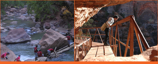
Crossing the Virgin River | Canyon Overlook Trail © Jason Rogers
To truly appreciate the beauty of Zion, visitors must go for a hike. The park has a large network of well-maintained trails with trailheads conveniently located along Zion Canyon Scenic Drive (ZCSD), Zion – Mount Carmel Highway (ZMCH), Kolob Terrace Road (KTR), and Kolob Canyons Road (KCR). Whether you’re looking for a casual leg-stretching stroll, or a boot-pounding multi-day backpacking adventure, you can find it here.
A few favorite short hikes are Weeping Rock (ZCSD), Hidden Canyon (ZCSD), Canyon Overlook (ZMCH), and Taylor Creek (KCR) Trails. Hidden Canyon Trail, located at Weeping Rock Shuttle Stop, is relatively short but quite strenuous and not for individuals with a fear of heights. You are required to traverse an exposed cliff, which drops off more than 1,000 feet. Hiking the same trail but bypassing its spur to Hidden Canyon will take you to East Rim Trail, which leads to Observation Point, one of the best vantage points in the entire park where you can look down on the main canyon and Angel’s Landing.
Trails to the top of Angel’s Landing and through Zion Narrows are discussed individually. These are classic hikes, two of the best trails in the National Park System that are renowned across the globe.
The following tables provide a more comprehensive list of Zion’s best hiking trails. Additional favorite hiking trails are designated with a thumbs up.
Zion Canyon Scenic Drive
Trail Name | Trailhead (# on map) | Length (Roundtrip distances unless noted otherwise) | Notes
Sand Bench Loop | Court of the Patriarchs Stop (1) | 3.4 miles | Moderate • Sandy trail used mainly for trail rides
Emerald Pools | Zion Lodge Stop (2) | 1.2 – 2.5 mi | Easy – Moderate • Hike to 1, 2, or 3 small pools
Angel’s Landing (favorite) | The Grotto Stop (3) | 5.4 miles | Strenuous • Adventurous hike with excellent views
Grotto | The Grotto Stop (3) | 1.0 mile | Easy • Connects Zion Lodge with Grotto Picnic Area
Kayenta | The Grotto Stop (3) | 2.0 miles | Moderate • Connects the grotto with Middle Emerald
Weeping Rock | Weeping Rock Stop (4) | 0.4 mile | Easy • Paved trail to a wall dripping spring water
Hidden Canyon | Weeping Rock Stop (4) | 2.4 miles | Strenuous • Follows a cliff ledge to a narrow canyon
Observation Point (favorite) | Weeping Rock Stop (4) | 8.0 miles | Strenuous • Look down on Angel’s Landing
Riverside Walk | Temple of Sinawava Stop (5) | 2.2 miles | Easy • Paved trail along the Virgin River
The Narrows via Riverside Walk (favorite) | Temple of Sinawava Stop (5) | 9.4 miles | Strenuous • Most scenic portion of the Narrows to Orderville Canyon • You will get wet
The Narrows (favorite) | Chamberlain’s Ranch to Temple of Sinawava (5, 6) | 16.0 miles | Strenuous • One-way, backpack (12 campsites) or day-hike (12+ hours), wading/swimming required
Zion – Mount Carmel Highway
East Rim (favorite) | Spur road past East Entrance (7) | 7.8 miles | Strenuous • One-way, long day-hike, backpack, or take Observation Point Trail to Zion Canyon Scenic Drive
Canyon Overlook (favorite) | East of the long tunnel (8) | 1.0 mile | Moderate • Short hike with excellent scenic value
Pa’rus | South Campground (9) | 3.5 miles | Easy • Paved trail follows Virgin River to Canyon Junction
Watchman | Watchman Campground (10) | 2.7 miles | Moderate • Short trail to a perch above the camp
Archeology | Zion Canyon Visitor Center (10) | 0.4 mile | Easy • Hike to small prehistoric storage buildings
Kolob Terrace Road
Right Fork | 0.5-mile past Park Boundary (11) | 11.8 miles | Moderate • Follows creek to waterfalls
Left Fork (favorite) | Left Fork Trailhead (12) | 9.0 miles | Moderate • Non-technical out-and-back to Subway
Wildcat Canyon Connector | Hop Valley Trailhead (13) | 8.7 miles | Moderate • One-way, ends at Lava Point Camp
Northgate Peaks | Wildcat Canyon Trailhead (14) | 4.4 miles | Easy • Lightly used flat trail to 7,200+ ft peak
Left Fork/Technical Subway | Wildcat Canyon Trailhead (14) | 8.1 miles | Strenuous • Requires rope, ends at Left Fork Trailhead
Wildcat Canyon | Lava Point (15) | 9.4 miles | Strenuous • Scrambling over difficult terrain
West Rim (favorite) | Lava Point (15) | 14.2 miles | Strenuous • One-way, ends at the Grotto via Angel’s Landing
Kolob Canyons Road
Taylor Creek (favorite) | Taylor Creek Trailhead (16) | 5.0 miles | Moderate • Leads to Double Arch Alcove
North Fork Taylor Creek | Taylor Creek Trailhead (16) | 5.0 miles | Moderate • Unmaintained spur from Taylor Creek
Kolob Arch via La Verkin Creek Trail (favorite) | Lee Pass Trailhead (17) | 14.0 miles | Strenuous • Trail can be made a long day hike or an overnight backpack trip
Timber Creek Overlook | End of Kolob Terrace Rd (18) | 1.0 mile | Moderate • Short hike, follows ridge to a peak