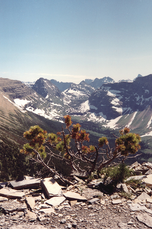
Looking into the Upper Nyack Valley
29 Dawson-Pitamakan
A day hike or backpack from Two Medicine Campground to Dawson Pass, 6.7 miles (10.8 km) one-way; from upper boat dock to Dawson Pass, 3.2 miles (5 km) one-way; loop from Two Medicine Campground, 18.8 miles (30 km); or loop from upper boat dock, 16.3 miles (26 km).
See map on 26 Scenic Point
Elevation gain: 2,935 feet
Elevation loss: 2,935 feet
Maximum elevation: 8,099 feet
Topo maps: Squaw Mountain, Mount Rockwell, Cut Bank Pass
Finding the trailhead: The Two Medicine North Shore trailhead is located on the north side of Two Medicine Campground near the end of Two Medicine Road, at the outlet of Pray Lake (Trailhead GPS: 48.49183 / –113.365836). Boat travelers will begin from the upper boat dock (Trailhead GPS: 48.474808 / –113.410906), meeting the trail after Twin Falls.
The Hike
The Dawson-Pitamakan (pronounced pit-AH-muh-kun) Trail runs from Two Medicine Lake to the Continental Divide and around into the Dry Fork drainage to form a long loop. It offers spectacular views of the spires of the southern Lewis Range, as well as good wildlife-viewing opportunities along its entire length. The trail may be hiked in its entirety in a single day, but it takes several days to fully explore the wonders of this region.
The trail begins at the Two Medicine Campground and winds around the north shore of the lake, beneath the hulking mass of Rising Wolf Mountain. Openings provided by avalanches from the mountain above allow excellent views of the peaks across the lake. The trail winds through a mixed forest that grades into spruce stands before finally emerging into an opening below Sinopah Mountain at the head of the lake. At this point a connecting trail from the South Shore Trail and the upper boat dock joins the Dawson Pass Trail. Travelers using the tour boat enter the trail here, having cut off the first 2.0 miles of the hike. A short side trip of 0.3 mile down this connecting trail brings you to the South Shore Trail to Twin Falls.
Looking into the Upper Nyack Valley

Pray Lake viewed to the west toward Mount Sinopah
From this point the trail ascends gently into the Bighorn Basin, a glacier-carved bowl filled with scattered stands of subalpine fir and lush meadows. At mile 4.8, a spur trail descends to No Name Lake, with its attendant campground. The Dawson Pass Trail continues to climb the south slope of Flinsch Peak, offering views of Mount Helen and the knife-edge wall of the Pumpelly Pillar. After 2.0 miles and 1,200 feet of steady climbing, the trail reaches the windy saddle of Dawson Pass. From this spot, vistas open to the glacier-carved valley of Nyack Creek to the south and the Lupfer Glacier, nestled high on the east slope of Mount Phillips across the valley. From Dawson Pass, mountaineers will find a fairly easy ascent up the south face of Flinsch Peak to its summit. Looking carefully, you can see where the 2003 Rampage Fire burned into the upper basin of Nyack Creek.
From Dawson Pass the trail turns north, following the Continental Divide along its west face around Flinsch Peak to an unnamed saddle at the head of the Dry Fork Valley. The trail crosses dry, barren rockscapes all along the divide, and backward glances reveal outstanding views of Lone Walker Mountain, Caper Peak, Battlement Mountain, and the spiny summit of Mount St. Nicholas. This area is home to bighorn sheep. The trail continues around Mount Morgan, and rocky pedestals on a spur ridge provide an ideal lunch spot among breathtaking views of Mounts Stimson and Pinchot across the valley, as well as the peaks to the south and north. The trail winds around to Pitamakan Overlook, which affords stunning views to the north and west.
From this point the trail turns east, following the north slope of Mount Morgan. A connecting trail from the Nyack wilderness rises to meet the Dawson-Pitamakan Trail in the course of its gentle descent to Pitamakan Pass, high above the large lake of the same name to the north. The trail to the north descends to Pitamakan Lake in the Cut Bank Creek Valley. Looking southward, the partial horn of Flinsch Peak soars above Oldman Lake, while pyramid-shaped Rising Wolf Mountain rises farther to the east. The trail descends steeply, switching back frequently through rocky ledges covered with wildflowers and firs, reaching a spur trail to the campground at the foot of Oldman Lake. This lake receives a fair amount of angling pressure, but remains good fishing for Yellowstone cutthroat trout in the one- to three-pound class. The campground is set in an open stand of old-growth whitebark pines, about 100 yards east of the lakeshore.
After leaving the campground the trail descends through parklike stands of fir separated by beargrass-studded fields along the Dry Fork. As the trail continues down the valley, it enters drier meadows of tall grasses reminiscent of high plains habitats. Nearing the foot of the valley, the trail enters a sun-dappled forest of lodgepole pine. Some 2.4 miles before reaching the Two Medicine Campground, a trail forks to the east, leading 2.6 miles through marshy aspen stands to the entrance station on the Two Medicine Road. The main trail swings southward, around the forested base of Rising Wolf, to terminate at the footbridge below Pray Lake.
Miles and Directions
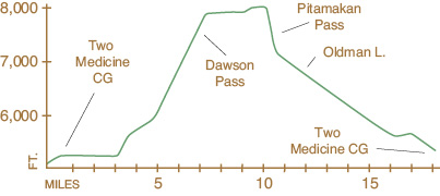
0.0Trail sign. Trail follows north shore of Two Medicine Lake.
3.3Junction with trail leading to Twin Falls and the South Shore Trail. Stay right for Dawson Pass.
4.8Junction with trail to No Name Lake and campground (0.2 mile). Stay right for Dawson Pass. Trail ascends steeply to Dawson Pass.
6.7Dawson Pass. Trail runs north, following the west face of the Continental Divide.
9.9Cut Bank Pass. Junction with trail into Nyack Creek. Stay right for Pitamakan Pass.
10.0Pitamakan Pass. Junction with the trail down Cut Bank Creek. Stay right for Oldman Lake and Two Medicine Campground. Trail descends steeply toward Oldman Lake.
12.0Oldman Lake.
12.9Oldman Campground. Trail descends gently, following the Dry Fork Creek.
16.4Junction with Dry Fork Trail. Stay right for Two Medicine Campground. Trail turns south, traversing the flanks of Rising Wolf Mountain.
18.8Return to Two Medicine Campground.