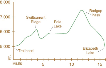
44 Poia Lake–Redgap Pass
A long day hike or backpack from Many Glacier Road to Poia Lake, 6.4 miles (10.5 km) one-way; from Many Glacier Road to Redgap Pass, 12.0 miles (19 km) one-way; or from Many Glacier Road to Elizabeth Lake foot, 16.6 miles (26.5 km) one-way.
See map on 43 Ptarmigan Tunnel
Elevation gain: 3,115 feet
Elevation loss: 3,133 feet
Maximum elevation: 7,520 feet (Redgap Pass)
Topo maps: Lake Sherburne, Many Glacier, Gable Mountain
Finding the trailhead: The trailhead parking lot is located approximately 3 miles west of the entrance station and 0.3 mile east of Apikuni Falls trailhead, on the north side of Many Glacier Road. Trailhead GPS: 48.805523 / –113.634338
The Hike
The Redgap Pass Trail offers a long, arduous route through the desolate Kennedy Creek Valley to the Belly River country to the north. Many backpackers opt for Poia Lake as a short-range backpack.
The trail begins at the Many Glacier Road, not far from the Apikuni Falls trailhead. The trail ascends as it winds eastward beneath the gabled south face of Apikuni Mountain. Lake Sherburne is visible in the valley below. After 3.0 miles, the trail mounts a wooded ridgeline, where it meets an insanely steep 1.0-mile cutoff trail from the entrance station coming in from the south. A few hundred yards beyond this junction, the trail passes the west shore of Swiftcurrent Ridge Lake, a marshy mere set in the deep forest of the crest of the ridge.
From this lake the trail drops northward into the Kennedy Creek Valley, descending through forests interrupted by small pockets of open marsh. Upon reaching the valley floor, the trail crosses a series of beaver ponds set among large aspens and turns west along the south bank of the creek. The Altyn limestone mass of Yellow Mountain rises to the north, with a pleasant waterfall nestled at its base, as the trail winds its way upward for 1.5 miles through gravelly rock gardens to Poia Lake. The lake was named for a half-mortal in Blackfoot legend named Star Boy who saved the life of Morning Star and thus restored the people to Sun Chief’s favor. The campground sits on a wooded knoll at the foot of the lake, looking westward toward the moors above the lake. The lake is deep and cold and is surrounded by blocky cliffs on both sides, but contains no fish.
The trail crosses the outlet of the lake and skirts its north shore on the way to Redgap Pass. From the head of the lake, the trail winds for 3.0 miles through open muskeg and wooded valley floor before ascending steeply toward the pass. As the trail passes out of whitebark and lodgepole pine forests into open subalpine fir parkland, beargrass blossoms dot the slopes on all sides. A backward glance reveals the hulking mass of Apikuni Mountain to the south, and Mount Henkel and Crowfeet Mountain crowd the head of the valley, with Kennedy Lake at their feet. As it reaches the windswept pass, the trail passes immediately beneath a towering chimney of reddish Grinnell argillite. Upon cresting the rise, the backpacker is greeted with stunning views of Old Sun Glacier lying at the base of the towering spires of Mount Merritt.
The trail then drops into a high, treeless cirque and winds around the west face of a rocky knob onto a series of high benches. Descending through ragged stands of pine, the trail makes its way to a junction with the Ptarmigan Tunnel Trail. From this point it is a foot-pounding 2.0-mile descent to the foot of Elizabeth Lake.
Miles and Directions
0.0Trail sign.
3.3Junction with Sherburne Cutoff Trail. Stay left for Poia Lake. Trail winds below Apikuni Mountain and ascends Swiftcurrent Ridge.
3.6Swiftcurrent Ridge Lake. Trail begins descent into Kennedy Creek Valley.
4.9Trail reaches Kennedy Creek and begins ascent to Poia Lake.
6.4Poia Lake Campground. Trail ascends gently along the Kennedy Valley floor.
9.4Trail begins ascent toward Redgap Pass.
12.0Redgap Pass. Trail begins steep descent to Elizabeth Lake.
14.6Junction with Ptarmigan Tunnel Trail. Turn right for Elizabeth Lake.
16.6Elizabeth Lake (foot) Campground.
Additional Hikes
Cracker Flats. A horse trail runs from the Cracker Lake Trail for 0.5 mile to Cracker Flats along the shore of Lake Sherburne. These flats are the former site of the mining town of Altyn, inundated by the formation of the reservoir. A trail once ran from the flats through forested slopes to the crest of Boulder Ridge, 5.0 miles to the east, but this trail has disappeared through many years of disuse.
Apikuni Falls. A short, well-maintained trail runs for 1.0 mile to Apikuni Falls from mile 10.4 of the Many Glacier Road. The high cirque beyond is accessible to climbers via a little scrambling. The enterprising bushwhacker who reaches the head of this tiny bowl is rewarded with views of Natahki Lake and the towering cliff walls surrounding it.
Kennedy Creek. A primitive route once ran up Kennedy Creek from a maze of jeep trails outside the park, linking up with the Poia-Redgap Trail. No trace of this trail remains, and hikers planning to use this route should forget about following the old trail and hike up the creek bed instead.