Denton Branch is a treasure hidden in the mist.
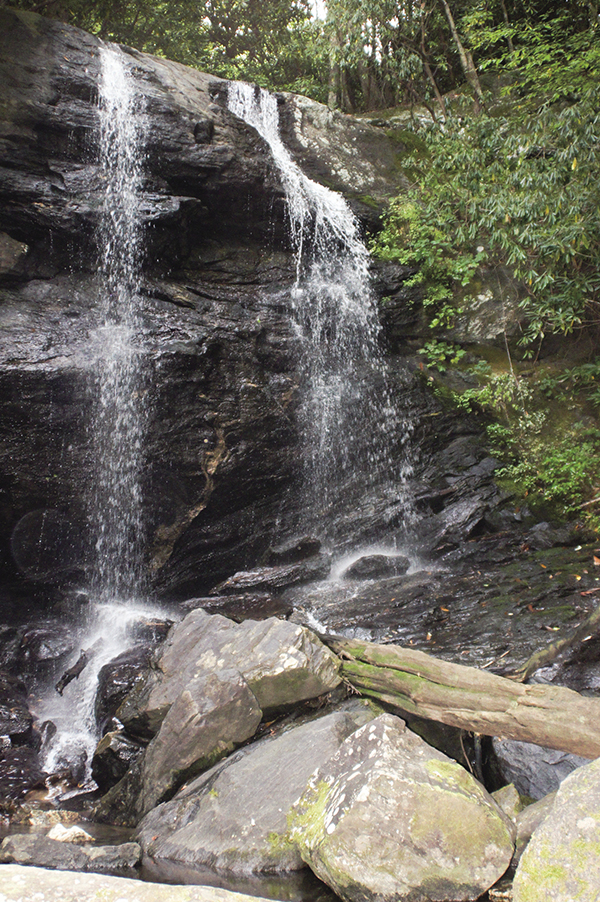
18 Denton Branch Falls
Splendid! Denton Branch Falls is one you’ll probably have to yourself—and a splendid experience it should be.
See map on 17 Flat Branch Falls
Height: 40 feet
Distance: 0.6 mile out and back
Blaze color: No blazes
County: Rabun
Land status: National forest
Trail contact: Chattahoochee National Forest, Chattooga Ranger District; (706) 754-6221; www.fs.fed.us
Maps: DeLorme: Georgia Atlas & Gazetteer: Page 16 A1; DeLorme: North Carolina Atlas & Gazetteer: Page 51 F6
Finding the trailhead: From the junction of US 76 west and US 441, drive west on US 76 for 7.9 miles. Turn right onto Persimmon Road at the sign for Tallulah River Campground and travel 4.0 miles to a left turn onto Tallulah River Road (FS 70). Continue for 1.4 miles to the Tallulah River Campground. Bypass the campground and continue straight ahead on the now unpaved Tallulah River Road for another 5.0 miles. Turn right onto Denton Branch Road, an unmarked dirt road and the first right turn after Chapple Lane, a short distance past the Valley Community Church. Follow Denton Branch Road for approximately 0.2 mile to where it dead-ends at the creek.
From the junction of US 76 and GA 197, go east on US 76 for 3.0 miles. Turn left onto Persimmon Road at the sign for Tallulah River Campground and follow the directions above.
GPS: N34 59.030 / W83 33.174
The Hike
The Denton Branch Trail is the continuation of Denton Branch Road. Follow the old roadbed as it heads north and cross the creek on foot. Continue upward on the old road, which soon becomes a narrow path and leads to a fork. Head right at the fork and follow the footpath toward the creek. Continue on the narrow path as you make your way uphill, following the creek upstream until the large and powerful Denton Branch Falls comes into view. The trail takes you across the creek once more to reach an island at the base of Denton Branch Falls.
Located within the Southern Nantahala Wilderness, Denton Branch, along with many other creeks, is part of the Tallulah River Basin. What that means is that they all flow into and feed the mighty Tallulah River. As you make your way to the trailhead, be sure to take a moment to appreciate the grand final product—the Tallulah River—as you pass it by. With its plentiful cascades, this river is always a pleasure.
Miles and Directions
0.0From the trailhead, head north across the creek. Continue upward on the old roadbed as it bends right (east) and then becomes a narrow path.
0.1Come to a fork, with an overgrown old roadbed leading up and to the left (north) and a narrow footpath leading to the right (southeast) and toward the creek. Go right (southeast) on the narrow footpath as it makes its way uphill and upstream.
0.3Cross the creek east-southeast to reach an island at the base of Denton Branch Falls (N34 59.136 / W83 32.941). Return the way you came.
0.6Arrive back at the trailhead.
Denton Branch is a treasure hidden in the mist.