Enjoy the “curling water” at Minnehaha Falls
24 Minnehaha Falls
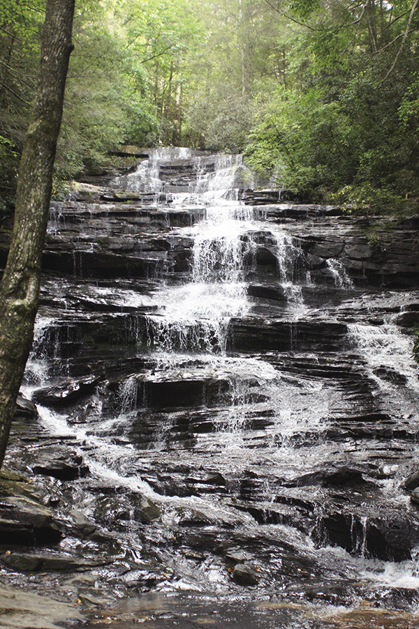
Terrific! The trail to Minnehaha Falls is also known as the Falls Branch Trail. Surprisingly, this waterfall does not seem to get a lot of traffic or praise. To me, however, Minnehaha seems almost alive. Teeming with character and uplifting in spirit, I highly recommend the “laughing waters” of Minnehaha.
See map on 23 Panther and Angel Falls
Height: 55 feet
Distance: 0.4 mile out and back
Trail surface: Hard-packed dirt
Approximate hiking time: 15 minutes
Blaze color: No blazes
County: Rabun
Land status: National forest
Trail contact: Chattahoochee National Forest, Chattooga Ranger District; (706) 754-6221; www.fs.fed.us
Maps: DeLorme: Georgia Atlas & Gazetteer: Page 16 D2
Finding the trailhead: From the junction of US 441 and US 76 east, drive south on US 441 for 8.9 miles. Turn right onto Old 441 south and travel 2.5 miles to a left turn onto Lake Rabun Road. Continue 6.2 miles before turning left onto Low Gap Road (where Lake Rabun Road becomes Seed Lake Road). Immediately turn left and drive over the bridge across Seed Lake. After approximately 0.1 mile, Low Gap Road makes a sharp bend to the right and a dirt road continues straight ahead. This dirt road is Bear Gap Road. Follow it along the lakeside for 1.5 miles to a small pull-off on the left.
From the junction of US 441 and the north end of the Riley C. Thurmond Bridge, drive north on US 441 for 1.7 miles. Turn left onto Old 441 south and follow the directions above.
From the junction of GA 197 and SR 356, drive north on GA 197 for 3.0 miles. Turn right onto Burton Dam Road at the Chevron Gas Station/Brooks Lil General Store and travel 7.2 miles. Turn right onto Low Gap Road (along the way, Burton Dam Road becomes Seed Lake Road) and follow the directions above.
From the junction of GA 197 and US 76, drive south on GA 197 for 8.2 miles. Turn left onto Burton Dam Road at the Chevron Gas Station/Brooks Lil General Store and continue 7.2 miles. Turn right onto Low Gap Road (along the way Burton Dam Road becomes Seed Lake Road) and follow the directions above.
GPS: N34 44.977 / W83 28.751
The Hike
Reach Minnehaha Falls by hiking on the Falls Branch Trail (#147). The trail begins by heading up some primitive steps and then continues its short but steady climb before leveling off and leading to the creek. Once at the creek, head left (south) and soon arrive at the base of Minnehaha Falls. The freshness of the cool breeze at the base of this one is truly exhilarating!
Minnehaha is a fictional Native American woman who was the lover of the main character in Henry Wadsworth Longfellow’s poem “The Song of Hiawatha.”
Hiawatha, founder of the Iroquois confederacy, and the fictional Minnehaha have lent their names to several places throughout Minnesota, including Minnehaha and Hiawatha Avenues in the city of Minneapolis. Often incorrectly translated as “laughing water,” the true meaning of Minnehaha is “curling water” or “waterfall.”
Miles and Directions
0.0From the trailhead, head up the primitive steps and hike southwest as the trail begins a slow but steady climb.
0.2The trail levels off and leads to the creek. Head left (south) and soon arrive at the base of Minnehaha Falls (N34 44.845 / W83 28.832). Return the way you came.
0.4Arrive back at the trailhead.
Enjoy the “curling water” at Minnehaha Falls