Ouzel Falls Trail System
The Ouzel Falls trail system begins at a bridge across Hunters Creek, south of the picnic area at the end of the road. A mere 0.3 mile of easy, pleasant trail brings you to Copeland Falls, a somewhat sudden drop in North St. Vrain Creek. It is a pretty spot and well worth a picture, but it’s no more spectacular than several unnamed places along the creek, which the trail follows for the next 1.0 mile. A detour left of the main trail hugs the creekbank for a short way upstream to one such picturesque spot, unofficially called Upper Copeland Falls. Be sure to stay on the detour or the main trail; do not trample through the narrow, flowery meadow between the two.
A little more than a 1.0 mile from Copeland Falls, you cross North St. Vrain Creek on a substantial log bridge. Just before the bridge, a path to the right to backcountry campsites extends up North St. Vrain Creek as a shortcut to the Thunder Lake Trail. It bypasses the very scenic Calypso Cascades and Ouzel Falls but also could be used as a return route from these destinations (see page 127).
Ascending beyond the bridge, you may notice some spot burns of the Ouzel Fire. Where the path bends left, you can walk straight ahead onto a large boulder and look down on the confluence of North St. Vrain Creek on the right and Cony Creek on the left. The trail continues through the subalpine forest along Cony Creek to Calypso Cascades, named for the little pink calypso orchids that bloom nearby in July. This outstanding whitewater scene is best photographed under overcast skies that help reduce light contrast between the white water and dark woods.
There is a trail junction at Calypso Cascades. The trail to the left is the Allens Park Trail (see page 135). Take the trail to the right for Ouzel Falls, crossing Cony Creek via two bridges. Remnants of spot burns from the 1978 fire are much more common beyond Calypso Cascades. Watch for deer or elk grazing on shrubs or flowers that sprout up in these burned areas. Climbing through a couple of wide switchbacks, you will see through the trees Mount Meeker and Longs Peak to the north. Meeker gives the false impression of being the taller of the two because it is closer.
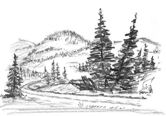
Past the switchbacks, begin to listen for the sound of Ouzel Falls, which ranks among the most spectacular in the park. From the trail’s bridge across Ouzel Creek it is possible to see the falls, but the best view is obtained by climbing up the hill just before reaching the bridge. There are worn paths of a sort weaving in and out. None is better than another, all are informal, and the very slick rocks can cause a tumble anywhere. The falls can be photographed from many different angles. Hope for overcast skies.
After crossing Ouzel Creek on the bridge, the trail circles below the ridge from which Ouzel Falls drops, reaching a spot where there is another view of Longs and Meeker. At 0.4 mile from the falls, you arrive at another trail junction. The Thunder Lake Trail goes right (see page 127); the Bluebird Lake Trail goes left.
Wild Basin
The Bluebird Lake Trail climbs steeply south from the junction to the crest of a moraine. Once on top, you are where the 1978 Ouzel Fire raged at its hottest, killing everything. Before the fire, most of the trees were lodgepole pines. Adapted to grow in burned areas, lodgepole almost certainly will be the tree species that will reestablish the forest. Views to the right to Tanima Peak and Mount Alice were not visible before the fire cleared the trees.
Beyond the area of complete deforestation, 1.3 miles after the previous junction, you reach the spur trail to Ouzel Lake. The Ouzel Fire began with a lightning strike near this lake, but damage along the trail and lakeshore was relatively light. Ouzel and Mahana Peaks are the most photogenic mountains viewed from the lake and are best pictured from the northern shore.
Ouzel Lake is dominated by the imposing bulk of Copeland Mountain. To climb Copeland, cross the lake’s outlet and fight your way through 0.5 mile of heavy subalpine forest to the top of a tree-covered ridge. Bear right there, following the ridge southwest for 0.5 mile to tree line. From tree line it is a tiresome tundra trudge past innumerable discouraging false summits to the top of the massive mountain. Copeland is the tallest peak on the southern side of Wild Basin, and the view from the top is spectacular.
The Bluebird Lake Trail continues past the Ouzel Lake spur for 0.5 mile to Chickadee Pond, passing through an area that was heavily burned. Past Chickadee Pond the trail traverses a small boulder field and passes through subalpine forest. The forest is followed by subalpine meadows, where yellow snow lilies bloom in late June. A small waterfall tumbles into this garden all summer. The path runs through rocks and back into trees and ever-increasing flowers to a meadow 5.6 miles from the trailhead. In a marshy area where the trail crosses Ouzel Creek, look for tiny white bog orchids among the many wildflowers. Often there is an ice-and-snow cave upstream at the foot of a gully where the creek has carved its way through a deep snowdrift.
After crossing Ouzel Creek the path steepens dramatically while climbing parallel to the stream, which is out of sight on the opposite side of a narrow ridge. The beaten track frequently disappears on bedrock or under snow, so it may be necessary to search for cairns.
In 1988 Rocky Mountain National Park bought three reservoirs—Bluebird Lake, Pear Reservoir, and Sandbeach Lake—from the city of Longmont. Dams impounding these reservoirs were dismantled, and the water dropped to its natural levels in those lakes. The massive concrete dam at Bluebird Lake, 6.0 miles from the nearest road, was the most difficult to remove and a major engineering feat. Here the dam’s removal affected the view less than at the other two lakes because Bluebird’s shore is mostly naked rock anyway. The best view of the lake and of Ouzel Peak rising out of the water is from the southern shore, over and around various rock outcrops.
The trail ends at the lake. To reach higher goals, cross the creek on rocks at the outlet, climb steep rock on the other side, and keep climbing to the north. After you have gained about 200 feet in elevation above the lake, bear to your left (west) across slabs of rock and tundra. Where the drainage becomes wider and less steep, you find Lark Pond. West from there it is an easy meander to Pipit Lake, about 1.0 mile from Bluebird.
Pipit is bleak, despite a colorful wildflower rim of bistort and avens. Isolation and Ouzel Peaks, stark rock towers, rise on either side. Between them is a barren pass, which looks almost as though the glacier that sculpted it melted only yesterday. Few patches of green soften the harsh landscape.
Closer examination, however, reveals that life has taken hold. Patches of tundra are vibrant with the color of alpine flowers, delicate yet rugged. The tundra plants are not so rugged, however, as to survive repeated trampling by hikers’ feet. Spread the impact and walk as gently as possible. From the top of the pass, a left-hand (south) turn heads along the ridgetop for the summit of Ouzel Peak. At first the ridge is narrow and nearly as steep on the west side as on the side you ascended. This is the line of the Continental Divide. Climb along the west side of the ridge, crossing rocks and tundra below the crest. Eventually you walk above the area of glacial action onto a broad slope leading to the top of Ouzel. The view is magnificent; you look down into Wild Basin and Paradise Park Research Natural Area.
A walk of an additional 1.0 mile along the tundra on the Continental Divide takes you to Ogalalla Peak. Halfway there you’ll bypass Cony Pass, a route of descent to either Junco Lake, south of Bluebird, or Cony Lake, in the Finch Lake trail system (see page 133).
A right-hand turn from the pass between Ouzel and Isolation Peaks leads north along the Continental Divide to Isolation Peak. It is a steep trudge along the narrow ridge past five false summits to the true summit. Because Isolation is higher than nearby Mahana and Ouzel Peaks, the view from there is superior. From Isolation the prospect south to Indian Peaks is unobstructed. (Isolation’s altitude is 13,118 feet, 200 feet less than the number recorded on the 1987 USGS map of Rocky Mountain National Park.)
A preferred route of descent is via the broad saddle between Isolation and Mahana Peaks. From the saddle you can descend directly to Eagle Lake or take a side jaunt to Frigid Lake. The direct route is to walk north downhill to a broad shelf below the saddle, follow a border of alpine willows to the edge of the shelf, and drop down to Eagle Lake. For the side trip to Frigid Lake, circle downhill from the saddle along the base of Isolation and cross snow to reach the lake. To reach Eagle from Frigid Lake, make your way down to the broad shelf and follow the route described above. You can circle Eagle Lake on the southern (right) shore, descend to Box Lake, and exit via the Thunder Lake Trail (see below).
Rather than climbing north and west from Bluebird to Pipit Lake, you can contour south from the Bluebird outlet and ascend the ridge between Bluebird and the outlet stream from Junco Lake. Junco Lake is 0.75 mile from Bluebird’s outlet. From Junco it is a rough 0.5 mile uphill to Cony Pass, which is situated south of Junco between a ridge of Copeland Mountain and the Continental Divide. From Cony Pass you can drop down to Cony Lake and exit via Finch Lake (see Finch Lake Trail System).
Back at the Bluebird–Thunder Lake junction, you can continue straight ahead along an easy grade on the Thunder Lake Trail. Cross a bridge over North St. Vrain Creek 0.4 mile from the junction, after which the shortcut trail comes in from downstream. Follow the main trail through a tight switchback and up steepening grades. At 1.3 miles from the bridge there is a junction with the Lion Lakes Trail, which goes to the right (see page 128).
Take the left-hand (lower) fork and continue on through a set of switchbacks and limber pines struggling amid rocks. Then subalpine fir and Engelmann spruce enclose the trail, and the grade becomes less steep. Soon a faint path strikes downhill to the left toward Box and Eagle Lakes (see page 129). Continuing on the level, you cross a large stream, then a smaller one, and at last reach the top of a wooded slope above Thunder Lake.
Descend with the trail to a meadow at the eastern end of the lake, 6.8 miles from the Wild Basin Trailhead. The meadow is marshy in spots; on close inspection, stalks of pink blossoms growing there turn out to be elephant heads, or little red elephants. A log patrol cabin at Thunder Lake is kept locked, but its long eaves give shelter from afternoon showers. Slosh east through the meadow to get damp feet and a good photo of the cabin, lake, and Boulder–Grand Pass with the peaks in the background.
To reach Boulder–Grand Pass, follow a trail around the northern (right) shore of Thunder Lake. Two streams feed the lake from the west. The first one (northernmost) comes from Falcon Lake, about 0.75 mile away and more than 580 feet higher than Thunder Lake. The second stream flows from Lake of Many Winds, a boulder-bordered pond immediately below the pass. Cross both streams and then, avoiding marshes, climb through woods and rocks to the vicinity of Lake of Many Winds. Circle it on the left and, staying to the right of a prominent snowfield, climb slowly up loose rock to the pass.
Broad tundra extends downhill from Boulder–Grand Pass toward as fine a string of paternoster lakes as ever a glacier carved (see East Inlet Trail in the Grand Lake chapter). Pater noster is Latin for “our Father” and refers to the Roman Catholic ritual of saying the rosary using a string of beads. Hence this geologic term describes a string of glacial lakes as being like beads on a string.
A left turn at the pass presents an uncomplicated ascent over tundra to the top of Tanima Peak. Despite weariness, stay alert to avoid damage to tundra plants. Hikers turning right at the pass have a much longer ridgetop journey to the summit of Mount Alice. Most people climb Alice from Lion Lakes and descend via Boulder–Grand Pass.
Leaving the Thunder Lake Trail at 4.8 miles from the Wild Basin Trailhead, the Lion Lakes Trail climbs straight up the hill for about 100 rocky yards. The grade then becomes more reasonable as the trail snakes through large boulders and levels on a crest. After a descent into subalpine forest, which gets your hopes up, the trail again shoots steeply uphill. Steepness is followed by moderation and steepness and moderation and swamp.
At the marshy area, the trail becomes faint while the mosquitoes become strong. Of course this is the best spot for photographing majestic Mount Alice to the west. A little pond here is usually still and provides a more dependable reflecting surface for Alice than does Lion Lake No. 1 a few yards farther ahead.
It is very pleasant to sit a spell on relatively soft and dry meadows by the shore of Lion Lake No. 1, but there is much to lure you on. A short walk along the northeastern shore presents good views of Tanima Peak rising behind a small rock-and-tree-covered ridge. Very lush meadows border the stream between Lion Lake No. 1 and Trio Falls. Immediately beyond the falls is Lion Lake No. 2, which may have more snow on its shore than Snowbank Lake, a short way farther up the drainage.
From Snowbank you can veer left to the top of a ridge leading uphill to the saddle between Mount Alice and Chiefs Head Peak to the north. Very fine photos of the east face of Alice are available from the ridge. Having hiking companions in the foreground of your pictures helps give an idea of the immensity of this sheer rock wall. From the saddle there is an interesting northern view looking down on Lake Powell in its cirque below McHenry Peak. Chiefs Head is seldom climbed from this saddle because there is a shorter way to get there (see page 131).
To reach the summit of Mount Alice, turn left at the saddle and descend for a short distance along the Continental Divide on rocks that look more difficult to pass over than they really are. The route is easiest on the right-hand (western) side of the ridge. Actually the rocks are quite interesting and definitely should be included as a frame for a photo of the North Inlet valley to the west. A little ridgetop notch at the bottom of the descent is a cozy, pleasant place, carpeted with patches of tundra.
From the notch it takes a certain amount of will to begin the very steep ascent, over boulders, of the final long slope to Alice’s summit. Again the route is less awful than it appears. As you approach the top, bear to the right (west) to avoid a false summit on the left (east). From the summit the bulk of Chiefs Head Peak diminishes the drama of Longs Peak and Pagoda Mountain; Mount Meeker, on the other hand, looks singularly pointed.
There is well over 1.0 mile of downhill tundra walking to Boulder–Grand Pass from the top of Alice. The alpine flowers can be magnificent. Carefully working your way down loose pebbles past Lake of Many Winds leads to glacier lilies and Thunder Lake, the goal of your lengthy descent. But unless you have a camp there, it is a long 7.0 miles out to the trailhead. After a fine climb like Alice, you will have a lot to think about on the way.
The track to Box and Eagle Lakes leaves the Thunder Lake Trail a little more than 0.5 mile before Thunder Lake. Descending through subalpine forest and meadows, the path disappears in the vicinity of North St. Vrain Creek. You should keep going in the same general direction through narrow, slanting meadows lying between cliff and forest and then climb a steep, narrow gorge that levels off to a marsh. Skirt the marsh on the left and climb through flowered subalpine meadows, following the brook that flows from Box Lake, a basin carved from solid rock by glaciers.
Eagle Lake was similarly carved in a shelf 70 feet higher than Box Lake. To reach Eagle, climb up the rocks on the left-hand (southern) side of Box. Make your way through the least-dense krummholz to the edge of the lake.
More trails in the krummholz along the northern shore take you to Eagle’s outlet stream. There, in early September, I found the largest arctic gentian I have seen. From the same spot you can take a good photo of Mount Meeker, featuring Box Lake in the lower part of the frame.
The most unusual sight at Eagle Lake appears a few yards downstream from the outlet: a tunnel. Big enough to walk into, with dynamite-fractured rock at its mouth and on the floor, it leads straight through the granite back toward Eagle Lake. It evidently was intended to provide a means of draining the lake when water was needed on the plains. Fortunately the tunnel remains unfinished—and Eagle Lake undrained.
Peak baggers may want to add Mahana Peak to their list by climbing it from Eagle Lake, even though Mahana is bounded on three sides by taller peaks. Make your way around the eastern end of Eagle Lake, and climb by the least-steep route over rocks to the shelf overhead. Follow the border of alpine willows uphill to a broad expanse below the Mahana-Isolation saddle. From there you can turn right to Frigid Lake, which sits below the base of Eagles Beak, nearly 1.0 mile hike from Eagle Lake, or you can climb on to Mahana, more than 1.2 miles from Eagle Lake. Head first for the broad, easy saddle, because an attempt to cut straight up the peak could lead to a bothersome false summit. The true top is on the right (southwest) side of Mahana.