Baker Gulch Trail System (Arapaho National Forest)
In 2011 the National Park Service dedicated the Bowen Connector Trail, a new 1.0-mile stretch linking the Onahu Creek Trail (see Onahu Creek–Green Mountain Circuit, below) with the Bowen/Baker Trailhead. This new path takes hikers intent on hiking in the vicinity of the Continental Divide away from the vehicle traffic on Trail Ridge Road as they walk between the Divide on Flattop Mountain and the Divide as it follows the crest of the Never Summer Range.
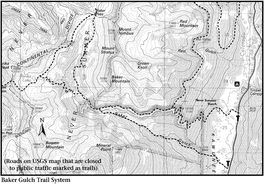
The Baker Gulch Trail is the easiest approach to a lake or peak in the Never Summer Range. Baker Gulch has felt the heavy hand of man, but the area remains beautiful and well worth visiting.
Access to the Baker Gulch Trail begins at a picnic area on the west side of Trail Ridge Road, 6.4 miles north of the Grand Lake entrance to the park and 13.9 miles southwest of Fall River Pass. From the picnic area an unpaved road extends west for 0.75 mile, nearly to the boundary of Arapaho National Forest. Because this road may be closed to private vehicles during summer, you should park at the picnic area and walk along the road.
From the picnic area the unpaved road crosses the Colorado River and meadows in the Kawuneeche Valley. As meadow gives way to forest, the road divides. Take the right-hand fork, which bends to the beginning of the Baker Gulch Trail, just short of the national forest boundary.
Once inside the national forest, the trail runs upstream on a ridge above the creek flowing down Baker Gulch. Distant views open when you reach clearings created by beavers about 1.5 miles from the forest boundary.
Just past the beaver workings, a series of short switchbacks leads to rocky rubble cast down from excavation for the Grand Ditch. Views open here across the narrow valley to Mineral Point and uphill into Baker Gulch. After you walk 0.5 mile along fractured rock slopes below the ditch, new vistas appear to the southeast, all the way to the Front Range. Chiefs Head Peak presents a very pointed aspect from this angle. From farther up the trail, Longs Peak comes into sight, looking very boxy.
You may not notice the distant peaks if your attention centers on the raspberry bushes growing among the rocks. At the right time of a good year, these bushes produce abundant and excellent fruit.
After walking for a long, hot mile over the foot-bruising rubble of ditch excavation, hikers are relieved to reenter subalpine forest. Soon the trail climbs steeply a short distance uphill to the ditch. When you cross the ditch via a substantial bridge, you enter a different world. Here no water has been diverted, and the subalpine growth is luxuriantly beautiful.
The trail becomes less distinct as it passes through three marshy meadows and enters cool, mature subalpine woods. Traveling on an easy grade, you feel real soil underfoot—dirt well laced with organic matter made available by adequate water. It is almost springy under foot.
About 0.5 mile from the ditch you enter a subalpine meadow and cross the stream flowing down Baker Gulch, from the right (north). Past the stream crossing there is a trail junction; the Baker Gulch Trail cuts right to head uphill toward Baker Pass, on the Continental Divide (see page 170). The Parika Lake Trail continues straight ahead and soon crosses the stream flowing from Parika Lake. It climbs directly uphill and away from the stream. There are a few switchbacks to help, but this stretch seems very steep in comparison with that below.
After a final switchback to the left, the path opens into a marsh, where you see a brook tumbling down a ravine from Farview Mountain. It is a nice setting, with little waterfalls and a pond surrounded by meadow.
The final 0.25 mile to Parika Lake is very steep, but rest stops offer views of the wall of the Never Summer Range, especially Baker Mountain and Mounts Stratus and Nimbus. Longs Peak still is visible far to the southeast, down Baker Gulch. After a trail runs off to the right toward Baker Pass (see page 170), it is just a few hundred yards farther to Parika Lake.
The lake lies in open tundra with an unnamed 12,253-foot bump to the north, Parika Peak directly west, and Farview Mountain to the southwest. In the vicinity of the lake’s outlet, a few stunted trees have been vandalized by an active ax directed by a small mind. Other unfortunate evidences of ignorant or malicious visitation appear here and there amid the krummholz, but the lakeshore itself remains relatively unspoiled.
From the outlet a trail climbs southwest across shelves overlooking the lake before angling north uphill to a broad saddle on the Continental Divide situated between Farview Mountain and Parika Peak. The trail runs to the left along the Divide toward Farview. From the saddle it is a fairly easy climb to the right to the doublehumped top of Parika. The summit cairn is located on the northwestern part of the peak, but deciding which point really is highest is tough.
Views from the Divide include Jack Creek drainage to the north, North Park to the west, and Bowen Gulch and Bowen Mountain to the southwest. You can follow the Divide down the eastern slope of Parika Peak to a saddle between Parika and its unnamed neighbor. There you meet a trail that ascends south from the Jack Creek drainage and continues vaguely through marshy terrain downhill to the northern shore of Parika Lake.
Back at the junction a few hundred yards short of Parika Lake, the trail branching to the north goes to the vicinity of Baker Pass. This route runs directly uphill to the pass without losing any elevation; you have to lose elevation from here if you wish to reach Baker Pass via the Baker Gulch Trail.
Back at the earlier junction just after the stream crossing, the Baker Gulch Trail heads north and away from the Parika Lake Trail, climbing gradually through a maze of elk routes and marsh. When the trail passes into forest, Engelmann spruce and subalpine firs are large and subalpine flowers—monkshood, larkspur, tall chiming bells—are abundant. Eventually the route becomes considerably less distinct and crosses a stream to climb to another track on the side of Baker Mountain. If you wish you can keep on climbing very steeply to the east to the summit of Baker.
From the Parika Lake Trail, it is a little more than 2.0 miles of exploration on the Baker Gulch Trail to Baker Pass. The overall grade is not difficult and the terrain is lovely, especially above the trees. A beautiful chartreuse tundra extends from tree line to what appears to be the pass. Actually, the top of the pass is on the Continental Divide and cannot be seen from tree line.
The trail crosses the divide into the Michigan River drainage. To the east the Never Summer Range is a high wall of broad tundra slopes except for the black cone of Mount Richthofen and the sharp ridge of Lead Mountain at the northern end of the wall. The gentle tundra slopes of Mount Cindy are to the northwest.
To descend from the pass to Parika Lake, you may have to hunt around a bit for a trail that materializes downhill and south of the pass. Head southwest below the ridge of the Continental Divide, past mine tailings and an old cabin. Stay above tree line, and watch for a distinct path that descends into the trees. It ends about 1.5 miles later at the junction with the Parika Lake Trail, a few hundred yards east of the lake.