Middle St. Vrain Trail System
To reach the Middle St. Vrain trail system, turn west off CO 72 at Peaceful Valley onto the road. Peaceful Valley is situated 4 miles south of the junction of CO 7 and CO 72, or 9.2 miles north of the town of Ward. Follow the road for 1 mile to the second campground, Camp Dick.
The 5-mile road beyond Camp Dick is a severe trial even for high-clearance four-wheel-drive vehicles, so hikers riding in a normal passenger car must park and walk. For a very pleasant 4.0 miles the Buchanan Pass Trail follows Middle St. Vrain Creek from Camp Dick to the wilderness boundary. Although it is called the Buchanan Pass Trail, the trail along Middle St. Vrain Creek is not the easiest or shortest route to the pass (see Routes from Beaver Reservoir). Just inside the wilderness boundary, the St. Vrain Mountain Trail (see page 238) climbs very steeply to the right.
The Buchanan Pass Trail continues west from the wilderness boundary along an old road now closed to bicycles and motorized vehicles. About 1.3 miles west of the St. Vrain Mountain Trail intersection, you reach a fork in the trail. The Buchanan Pass Trail bears left to cross the creek on a log bridge, beginning a long switchback east that leads eventually to the pass. About 1.1 miles along the way is the trail that branches up to Red Deer Lake (see Routes from Beaver Reservoir).
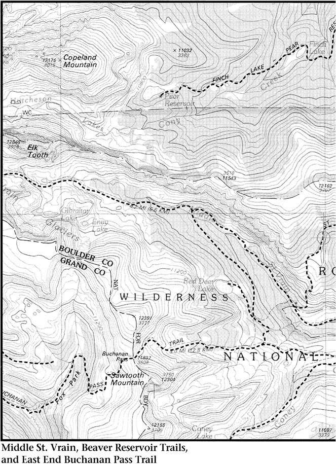
Veering right at the fork takes you up the Middle St. Vrain Valley on the St. Vrain Glacier Trail. The trail crosses the creek several times. Eventually a bend to the left climbs 0.5 mile into a cirque containing Lake Gibraltar, source of Middle St. Vrain Creek. The outlet from Lake Gibraltar flows at once into a smaller lake unofficially called Little Lake Gibraltar. Over a low ridge to the east of the trail at Lake Gibraltar there is another cirque, which contains Lake Envy. Towering above all these lakes are spectacular cliffs on which hang the St. Vrain Glaciers.
For those who can drive to the road closure, the Middle St. Vrain trail system offers alternative routes to two Wild Basin destinations. To reach Hutcheson Lakes, leave the trail about 3.5 miles beyond the road closure. Climb over loose rock up the very steep north wall of the Middle St. Vrain Valley wherever it looks least difficult. From the top of the ridge between Middle St. Vrain and Cony Creek drainages, descend with care over more loose rock to Hutcheson Lakes.
A shorter approach to Ogalalla Peak leads to a much more difficult final climb than do the approaches from Ouzel Peak or Cony Pass. When the trail bends south to Lake Gibraltar, keep going west (uphill) to a small tarn unofficially called Pika Lake. Continue on to the head of the Middle St. Vrain Valley, and climb into the cirque containing the largest and northernmost of the St. Vrain Glaciers. Ogalalla lies straight north of this body of ice. Between the cliff above the glacier and the peak there is a very steep slope covered with loose rock. Climb this talus slope to the lowest point on the skyline southwest of Ogalalla. This spot is on the Continental Divide. Once there you have a short walk east over relatively level tundra to the summit of Ogalalla.