Trails from Hessie
A quarter mile from the road to the Fourth of July Trailhead (see page 244) is the site of the 1890s mining camp of Hessie, a beginning point for trails in the drainage of South Fork Middle Boulder Creek. The road becomes a cobblestone creek bed. If lacking a vehicle with high enough clearance to surmount the water, you should park and walk 0.25 mile to the Devil’s Thumb Trail. This trail into Indian Peaks Wilderness once was a four-wheel-drive road, built before the establishment of Roosevelt National Forest. USFS signs help guide hikers through a maze of old mining and reservoir roads to popular destinations.
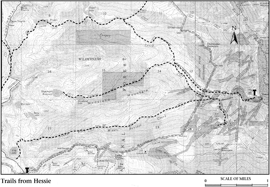
Less than 1.0 mile up the old road, the Devils Thumb bypass trail to Jasper and Devils Thumb Lakes branches to the right. This trail rejoins the old road system on the reservoir service road for Jasper Lake. Heading up the trail on the north side of Jasper Creek and returning down the old road adds variety to a hike to Jasper and Devils Thumb Lakes. Photographers may wish to pay special attention to dramatic cascades on the South Fork Middle Boulder Creek just upstream from the old road bridge, a few yards beyond the junction with the trail to Devils Thumb Lake.
About 1.0 mile up the old road, the 0.25-mile Lost Lake Trail heads left to Lost Lake, the site of mines that supported Hessie. Just beyond the Lost Lake spur, the King Lake Trail heads left to follow South Fork Middle Boulder Creek for 3.5 miles, eventually climbing steeply above tree line to an indistinct splitting of the way. Where the King Lake Trail turns sharply left after reaching a milder grade atop a glacier-carved shelf below the Continental Divide, you can turn sharply right to reach Betty and Bob Lakes, 6 and 6.2 miles, respectively, from Hessie. Easy-to-miss snatches of trail here and there lead through krummholz and across moraines to the lakes. Both are dammed by terminal moraines formed during successive pauses in the retreat of a glacier that originated in the cirque now occupied by Bob Lake. The view from Bob up to the Continental Divide is particularly memorable. The mosquitoes in August can also be very memorable.
Perched below Rollins Pass, King Lake is 5.2 miles from Hessie. It is an easy 6.0-mile walk downhill from the crumbled site of Corona, at Rollins Pass, past King Lake to Hessie. Arranging transportation at both ends of the trail can be complicated. The eastern side of the Rollins Pass Road is closed just above Yankee Doodle Lake on the east side. The only way to drive to Rollins Pass is from US 40 near Winter Park (see Corona Trail in the West of the Divide chapter).
Continuing right from the King Lake Trail, the old road follows Jasper Creek to Jasper Lake (see Fourth of July Trailhead). On the way, another branch left leads to Woodland Lake and Skyscraper Reservoir. Rotting cabins appear from time to time amid raspberry bushes along the old road to Woodland Lake, 4.2 miles from the trailhead. Almost 0.5 mile beyond is Skyscraper, nestled between two ridges jutting east from the Divide. Bob and Betty Lakes are on the opposite side of the lower ridge, seen to the left (south) across Skyscraper. Surmounting this ridge will lead to an alternate route back to Hessie along the King Lake Trail.