|
DISTANCE: 2.9 miles TYPE: Out and back TOTAL ELEVATION GAIN: 1,030 feet MAXIMUM ELEVATION: 3,180 feet DIFFICULTY: Moderate HIKING TIME: 2 hours |
Located along the Escarpment Trail, Burnt Knob rewards hikers with panoramic views of the Blackhead Range. The vista isn’t terribly far from one of the more popular parking areas in the Catskill Park, but it is rarely a destination point, due to the plethora of views scattered throughout the surrounding wilderness. The described route makes for a great day trip, with plenty of options to lengthen your hike if you’re feeling adventurous.
GETTING THERE
Take Exit 20 (Saugerties) from the New York State Thruway, then turn left onto NY-212/NY-32. At the traffic light, take a right onto NY-32 North. In 6 miles, continue straight onto NY-32A. In 1.9 miles, turn left onto Route 23A, and drive up the winding mountain road toward Tannersville. After driving through Tannersville, turn right at the traffic light onto Hill Street (County Route 23C). Head north on NY-23C for 6.1 miles. Turn right onto County Route 40, and follow it until you come to the small town of Maplecrest, in about 2 miles. Veer right onto Big Hollow Road and drive for 4 miles. The parking area is at the very end of the road. Be aware that the last mile or so of this road is considered seasonal and is not maintained during winter months. During times of heavy snowfall, you may need to park on the side of the road, as the parking area is rarely plowed.
GPS SHORTCUT
Type “Acra Point” into Google Maps and your GPS will navigate you to the appropriate trailhead. The Acra Point hike here also begins from this trailhead.
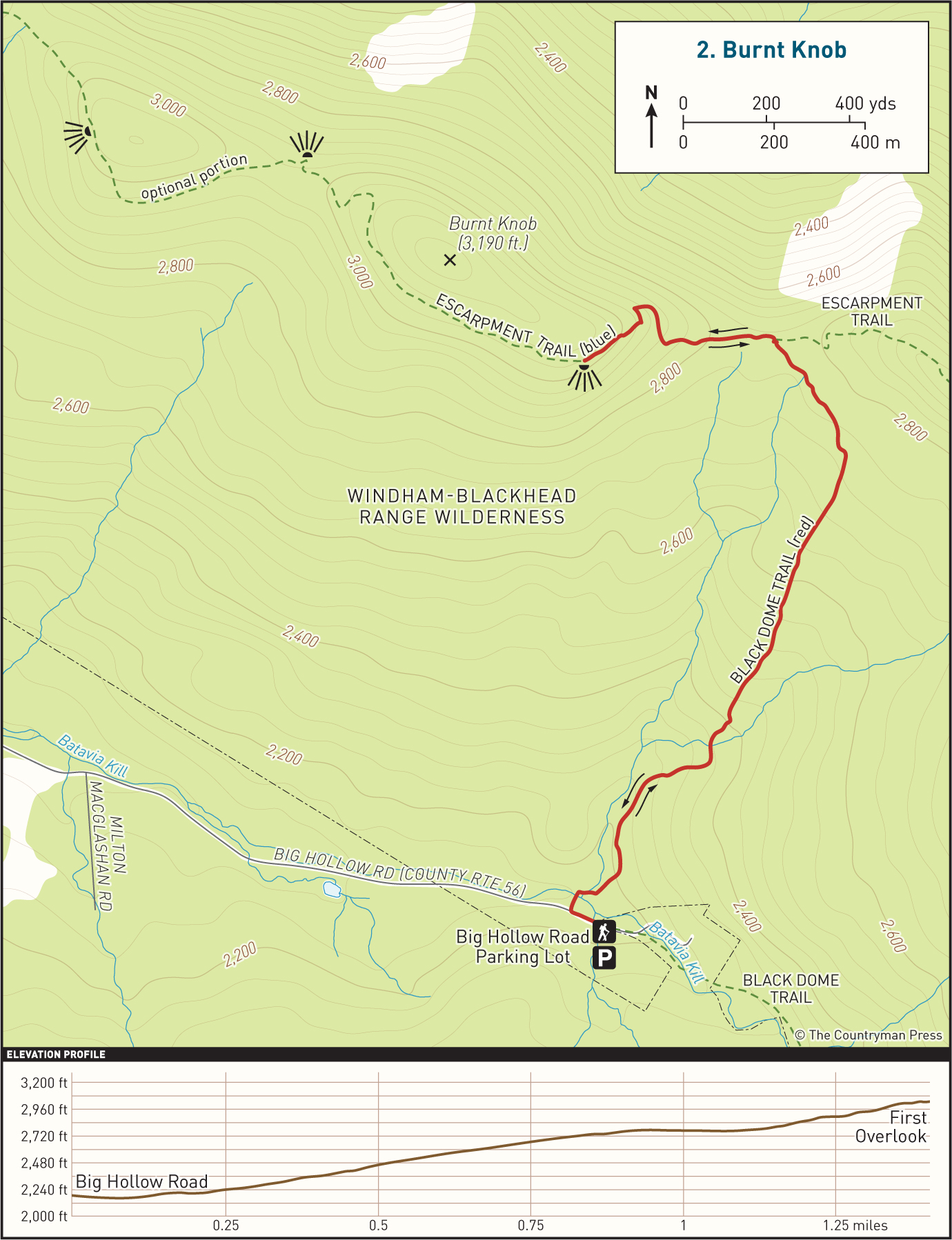
THE TRAIL
Walk up Big Hollow Road toward Maplecrest. The trailhead is slightly before the parking area on the right side of the road. Pick up the Black Dome Trail and follow the red blazes into the woods, crossing the Batavia Kill on a footbridge. The path will lead you to yet another water crossing shortly thereafter. This crossing lacks a footbridge, and in periods of high runoff or in very wet seasons, it may be impossible to cross without getting wet. Pick your way across the run and continue following the blazes. For the next half mile the trail follows the stream uphill, occasionally crossing small seasonal tributaries and runs feeding into the main flow. Eventually, you will start to veer left, leaving the stream behind.
The forest here is mostly hemlock, spruce, and various hardwoods. Look out through the trees when you stop to take a break, as you’ll be able to catch obscured views of the Blackhead Range in the distance to the south. You’ll have a wide panoramic view of the range at the vista, but these little glimpses will whet your appetite and keep you going when you’re out of breath. The grade is relatively steady for the entire ascent.
After 1.1 miles, the Black Dome Trail ends at the junction of the Escarpment Trail. Turning right here will take you to Acra Point, another fantastic vista, in just 0.7 mile. But to stick to this route, turn left here and follow the blue blazes for 0.35 mile. There is a short steep climb in about a tenth of a mile, but the trail levels significantly afterward. The viewpoint will be on the left, boasting wide-open views of the entire Blackhead Range and the valley below. The viewing area is broad and flat, with enough room for several people to comfortably break, making it a great place to sit back and have a snack.
When you are finished taking in the view, rejoin the Escarpment Trail and return the way you came, descending via the Black Dome Trail. Alternatively, you could continue heading northwest for 1 mile on the blue-blazed Escarpment Trail. This will take you to two additional viewpoints. The first is on the right side of the trail, facing north about 0.5 miles from Burnt Knob, and the second is to the left side of the trail, a mile from Burnt Knob. From the second of these vistas, you can see Thomas Cole Mountain and Camel’s Hump to the left and Windham High Peak towering to the right. The trail to these viewpoints largely follows the ridgeline. There are a few rolling hills, but otherwise there isn’t a great deal of fluctuation in elevation. Including this section of trail on your hike will add 2 miles to your trip, for a total of 4.9 miles overall. Return to your vehicle the same way you came.

BLACKHEAD AND BLACK DOME AS SEEN FROM BURNT KNOB