
Virginia Lakes Basin to Green Creek
TRAIL USE
Day Hike, Backpack, Horse
LENGTH
11.8 miles, 4–8 hours (over 1–2 days)
VERTICAL FEET
One-way:
+1,520', –3,370'
DIFFICULTY
TRAIL TYPE
Point-to-Point
FEATURES
Lake
Stream
Autumn Colors
Wildflowers
Great Views
Camping
Swimming
Secluded
Historical Interest
FACILITIES
Bear Boxes
Campground
Horse Staging
Resort
Restrooms
Water
Virginia Lakes attracts a lot of outdoor enthusiasts (hikers, equestrians, anglers) because there is much to offer—and a paved road makes the drive there easy on the passengers. For the hiker there are several general possibilities. First, you can spend a relatively short time exploring one or more of the Virginia Lakes. Second, you can climb above them in rarefied air to Burro Pass to enjoy the views. Third, you can either make a long day hike or a moderate backpack beyond the pass down to the Green Creek Trailhead, passing 10 lakes and several ponds along a mostly descending route. And fourth, you can either day hike to Summit Lake or backpack beyond it down into upper Virginia Canyon, which is the easiest-to-reach classic glacier-smoothed subalpine gorge of the Yosemite north country. This route is popular with equestrians entering Yosemite.
Permits
Overnight visitors require a wilderness permit for the Virginia Lakes Trailhead (as described) or Green Creek Trailhead (hike in reverse), issued by Humboldt–Toiyabe National Forest. Pick up your permit at the Bridgeport Ranger Station.
Maps
This trail is covered by the Tom Harrison Hoover Wilderness map (1:63,360 scale), the National Geographic Trails Illustrated #308 Yosemite NE map (1:40,000 scale), and the USGS 7.5-minute series Dunderberg Peak map (1:24,000 scale).
With a trailhead approaching 10,000 feet, small snow patches just below the pass can linger well into July. However, by early July the route to the pass is generally well traveled and easily passable—and the alpine wildflowers are at their height. To avoid crowds, hike in September, when fall colors abound.
Dunderberg Peak’s periodic rockfalls create talus that is home for yellow-bellied marmots and pikas.
Finding the Trail
From Bridgeport, drive south on US 395 through the town to the Bridgeport Ranger Station, near its south edge. Continue 12.1 miles south on US 395 to Conway Summit and the Virginia Lakes Road (Forest Service Road 21) junction. If you’re traveling from the south, Conway Summit lies 12.8 miles north of the CA 120 junction in Lee Vining. Turning west onto Virginia Lakes Road, this broad, paved road climbs 4.5 miles to an easily missed junction with broad, well-graded Dunderberg Meadow Road (FS 20). This dirt road winds 9 miles north to a junction with Green Creek Road (FS 142) and is one route to the previous trip’s trailhead and the shortest route to shuttle a second car to the ending point for this point-to-point walk. Once at the Green Creek Road junction, turn left (west) and follow FS 142 for 5.1 miles to an obvious trailhead parking area, with an outhouse and water spigot, on the right. You can also detour down to US 395 and drive up Green Creek Road from its junction with US 395 if you wish to minimize dirt road driving, but Dunderberg Meadow Road is in good condition and considerably faster.
As your hike starts from the Virginia Lakes Trailhead, for now continue straight an additional 1.6 miles along the paved Virginia Lakes Road up to a moderate-size trailhead at road’s end, passing along the way first the Virginia Lakes Pack Station on the right, a tract of vacation homes, the Virginia Lakes Resort (with café) on the left, and finally the Trumbull Lake Campground on the right. Just past the campground, the road reverts to gravel. Trumbull Lake Campground has a water faucet.
Trail Description
At an elevation of 9,850 feet, the trail departs from the west side of the parking area, near the toilets and information signs. ▶1 Numerous use trails around Big Virginia Lake can make it difficult to discern the correct route—turn right (northwest) at the lake’s edge and continue until the shoreline bends west. The trail now briefly jogs north, entering a stand of aspens, curving left again where you reach a junction with a horse trail merging from the right (0.2 mile). ▶2

Under sparse subalpine shade, your trail quickly passes a tarn and then reaches the Hoover Wilderness boundary. A fisherman’s trail branches to the left, dropping slightly to 9,886-foot-high Blue Lake. Staying on the main route, Blue Lake comes into view a moment later, cupped in steep slopes of ruddy-brown hornfels—a metamorphic rock that doesn’t have layers. Early summer colorful wildflowers emerge from the scant soil covering the rock. As you climb gently to moderately above the north shore of Blue Lake, you cross talus derived from rusty-weathered Dunderberg Peak high to your north.

At Blue Lake’s western headwall, your way climbs steeply, the ascent pausing briefly as the trail rounds an immense talus fan to the verdant banks of Moat Lake’s merrily descending outlet stream. Soon after you step across the creek, a steeply clambering use trail ascends to the unseen lake. Now your trail switchbacks more gradually up a forested hillside to reach a small miner’s cabin in a clearing. After another short climb on steep bluffs, you arrive at the outlet of Cooney Lake (1.2 miles), ▶3 which occupies a low bench in this austere timberline upland. A few small camps are found south of the inlet in wind-tortured knots of whitebark pines, reached by a footpath across the low bench. As you leave the lake, views open to your trip’s barren high point, Burro Pass (a local name; the pass is unnamed on maps). The pass saddles the western horizon; its metamorphosed tuffs look cream-colored against the surrounding, darker, metamorphosed lavas, such as Black Mountain, to your south.

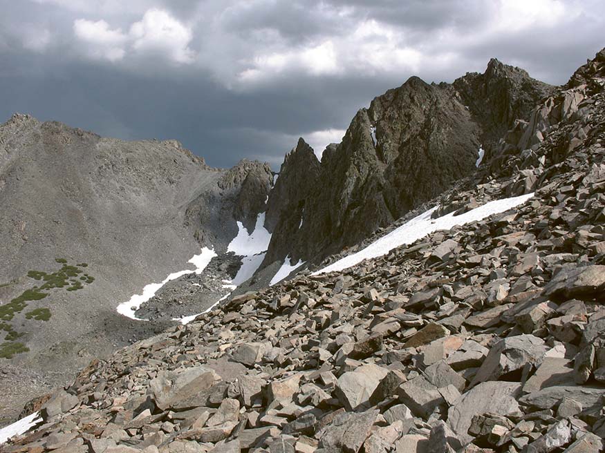
View south from Burro Pass
Beyond Cooney Lake you ascend gently west into a rocky-meadowed draw. Just before you step across infant Virginia Creek, a short path leads north to several better camps. The creek is crossed via rocks and logs, requiring a keen sense of balance (or wet feet) during high flows but becoming a series of simple steps by midsummer. Across the creek you find a second rolling bench, which harbors a clutch of small lakelets—the Frog Lakes—named for once-numerous mountain yellow-legged frogs that have disappeared due to disease and nonnative, but tasty, trout. Now you swing south of the meadowy, lowest Frog Lake—often an early-summer mosquito haven—then ascend above some lush alpine turf, step across the river again, and reach the highest lake, where good camps are found among scattered whitebark pines.

You now leave the meadows and lakes behind and climb steadily through a rocky landscape dotted by whitebark pines. Finally, the trail resolves into switchbacks, then leaves the last whitebark pines behind for a true alpine ascent along the west wall of a cirque. The relatively warm, mineral-rich, easily weathered, water-holding metavolcanic soil here supports an abundance of alpine wildflowers rarely seen elsewhere along a trail. Views across the Virginia Lakes basin continue to improve, then after a burst of short switchbacks—often snow covered through much of July—you gain broad 11,130-foot-high Burro Pass (2.9 miles). ▶4 By walking north just a minute from the trail’s high point, you can also view the Hoover Lakes, at the base of Epidote Peak, and, in the northwest, Summit Lake, at the base of Camiaca Peak. Continuing off-trail a little higher along this ridge affords views to pointy-tipped Matterhorn Peak, another valley to the northwest.

From the barren, windswept crest, you make an initial descent south, then momentarily switchback northwest. Colorful wildflowers continue to emerge beneath the boulders, especially where you cross a small trickle. Your trail switchbacks northwest down through a small, stark side canyon to a sloping subalpine bench, with small campsites tucked north of the trail. After a third set of switchbacks, you arrive at a junction on a small bench (4.6 miles), ▶5 just above East Fork Green Creek. Here you have a choice: Head over to Summit Lake (see the Option), or descend a popular route past a half dozen lakes and several ponds en route to the Green Creek Trailhead, the primary route described here.
From the junction, your Green Creek Trail descends northeast past a tarn to an excellent overlook downcanyon to the windswept, largely desolate Hoover Lakes. Beyond, light-colored granitic Kavanaugh Ridge peeks over the massive red shoulder of Dunderberg Peak. Heading north, you descend the bench you’ve been following to the drainage and step across East Fork Green Creek, then traverse across talus above the west shore of upper Hoover Lake before traversing its north shore. At the northeast corner of upper Hoover Lake, you cross its wide, rocky outlet stream (5.45 miles), and in this vicinity you could hike south briefly upslope to exposed camps on small flats above the lake’s east shore. For those seeking more sheltered or larger sites, continue ahead to East Lake and Green Lake.
Below Hoover Lake, you drop easily over willowed benches, then circle above less-visited Gilman Lake to cross the East Fork Green Creek again, this time in a stand of hemlocks and whitebark pines (6.1 miles). ▶6 Soon afterward, the gradient lessens, and your route rises gently to cross an expanse of bare rocks, still mostly red metamorphic rock. But you also pass outcrops of conglomerate rocks, easily recognized as a collection of pebbles, cobbles, and boulders cemented together. Once past Gilman Lake, you encounter a spur trail used to access campsites on the knob at the lake’s north end, and then follow a shallow trench that leads shortly to small, green Nutter Lake (6.55 miles). Camps lie below your trail in subalpine conifers at Nutter Lake’s west end. A short northwest climb from Nutter Lake on a pine-mat manzanita–patched slope next presents East Lake, the largest of the Green Creek lakes, spread 100 feet below you under the iron-stained talus skirts of crumbly Epidote Peak, Page Peaks, and Gabbro Peak. The trail parallels the east side of East Lake for most of its 0.75-mile length, passing scattered, usually small campsites on granite benches shaded mostly by whitebark pines. You then reach an extensive camping complex at East Lake’s outlet (7.4 miles). ▶7 Fishing is good here for rainbow trout.

Your trail makes the first of three outlet creek crossings just past the lake, then makes an easy 0.3-mile descent to where it begins a moderate 500-foot drop in a relatively dense conifer forest, soon reaching a second crossing. In early summer the creek can be swift, and a slip here will send you down its cascading course—take care. Beyond a third crossing, also requiring care, the trail completes another set of tight switchbacks and then levels off, at which point you can branch left, west, toward Green Lake (8.65 miles) ▶8 and its excellent campsites. At an elevation of 8,940 feet, the lake can be on the nippy side; after a refreshing swim, you’ll likely find yourself basking on nearby slabs. However, the lake’s relatively large volume and chilly temperatures make it ideal for a good-size trout population.


From the lake you have to cross Green Lake’s outlet creek, and in early summer it can be raging, so you’ll need to find a log or two to cross it. You’ll then make a brief jaunt to a junction (8.9 miles) ▶9 with a trail climbing steeply 1.6 miles up to West Lake, situated in a basin of barren rock—the shores have few trees and above lies a ring of rocky peaks.
From the junction, the Green Creek Trail, the right-hand option, starts a descent, and a rocky knob soon provides a great view down the Green Creek canyon, the best of several to come. Next, the trail descends through a swath of luxuriant wildflowers that dazzle the eyes with myriad colors. By early August, the display is diminished, but so is the water flowing down the trail. In fall this stretch of trail is equally showy, as the leaves on the scrubby aspen trees turn a brilliant yellow. Beyond, you reenter a taller forest dominated by lodgepole pines and aspens, and you soon descend a dozen short, rocky switchbacks. You soon cross out of Hoover Wilderness and traverse along a rocky bench. Below you, tall, stately Jeffrey pines dominate the forest, and you complete your descent with a brief drop to a step-across creek crossing and reach the dirt Green Creek Road (10.9 miles). ▶10 You follow the road for about 5 minutes before taking a trail branching left (11.2 miles), ▶11 which winds and undulates downcanyon, passing above the campground and reaching the parking area of the Green Creek Trailhead (11.8 miles). ▶12 (Note that you could follow the road all the way to the trailhead, and indeed this is the slightly quicker route, but the trail is a much more scenic way to end your excursion.)

OPTION: Summit Lake
From the junction ▶5 you turn southwest and drop into a seasonally verdant—indeed downright marshy—meadow and cross three broad, shallow, cobble-paved freshets. Just beyond the meadow you step across the faster flowing outlet stream from Summit Lake and begin a short but steep and cobbly ascent, paralleling the outlet stream. Soon the climb moderates, and you traverse dry sedge flats and benches past some good—but small—hemlock-bower campsites. A tent is advisable because the scattered trees offer little wind protection. Nearing the outlet of usually windswept Summit Lake, you level off (0.4 mile from main route). Angling for small brookies is fair. Now begins a long traverse curving west along the north shore to Summit Lake Pass. In midsummer the moist flats you pass through are an astonishing burst of color, with dense fields of arnicas and lupines providing foreground for your photos. At the west end of the lake, you reach the Yosemite National Park boundary, barely rising above the 10,195-foot-high lake (1.05 miles from main route). Standing at the pass, you are gazing down into remote, lush Virginia Canyon. Staring at the skyline, you can readily identify Virginia Peak, a pointed metamorphic summit that rises above and north of the summits of Stanton Peak and Gray Butte. A few more exposed campsites can be found among clusters of whitebark pines near the pass. Sunset views can be quite spectacular from here.
Looking north to the Hoover Lakes
| ||
▶1 | 0.0 | Start at Virginia Lakes Trailhead |
▶2 | 0.2 | Left at stock trail junction |
▶3 | 1.2 | Cooney Lake |
▶4 | 2.9 | Burro Pass |
▶5 | 4.6 | Right at Summit Lake junction |
▶6 | 6.1 | Gilman Lake inlet |
▶7 | 7.4 | East Lake outlet |
▶8 | 8.65 | Green Lake spur |
▶9 | 8.9 | Right at West Lake junction |
▶10 | 10.9 | Reach Green Creek Road |
▶11 | 11.2 | Left off Green Creek Road onto trail |
▶12 | 11.8 | Finish at Green Creek Trailhead |

 MILESTONES