
PHILIP WAS AT HOME IN SOUTHEASTERN MASSACHUSETTS, an area he and his family frequented for hunting and fishing and that he also knew from his journeys to Plymouth and Boston. This corner of the Old Colony thus heard the rumblings of King Philip’s War several years before its outbreak, in the death of Philip’s brother, Alexander, and in the equally infamous Treaty at Taunton. It also saw the start of King Philip’s War with the attack on Swansea, and the final passing of native resistance with Anawan’s capture at Rehoboth.
When Major Josiah Winslow set off with, in Hubbard’s estimate, “eight or ten stout men . . . well armed”1 in the summer of 1662 to bring Alexander before Plymouth authorities, he intended to ride to “the said Alexander’s dwelling, distant at least forty miles from the Governour’s house.”2 Instead, Hubbard reported, Winslow discovered Alexander at a “hunting-house within six miles of the English towns.”3 This has generally been taken to mean the area around Monponsett Lakes in Halifax where Massasoit and his sons kept a summer camp. In 1877, a local resident identified Alexander’s specific campsite as being on the southwesterly side of White Island, though the only proof offered was local tradition.4
Today, Route 58 crosses White Island along a connecting causeway that separates the two bodies of water that comprise Monponsett Lakes (or Ponds). The Halifax Historical Society has placed a marker at the intersection of Route 58 and White Island Road that reads:
Alexander’s party watch in shock and sadness as the sachem dies. His mysterious death was a blow both to his own Pokanoket and to the other Wampanoag peoples seeking leadership after Massasoit’s death. (Courtesy of the Haffenreffer Museum of Anthropology, Brown University)
NEAR THIS
SPOT WAMSUTTA WAS TAKEN
PRISONER BY
MAJ. JOSIAS WINSLOW.
AN INCIDENT SAID
TO HAVE PRECIPITATED
KING PHILLIP’S WAR.
PLACED BY
THE HALIFAX
HISTORICAL SOCIETY
In 1984 Maurice Robbins attempted to reconstruct the Monponset Path, the route by which Winslow probably traveled to reach Alexander’s camp. Robbins believed that Winslow would have begun his ride in present-day Kingston, at the junction of Court Street and Wapping Road, traveling west on Wapping Road about four miles to Harrub’s Corner in Plympton, where the street becomes Country Road:
About one and a half miles further the street name again changes to Plymouth Street (at the Plympton town line). Another mile through the town of Halifax brings out to Monponsett Pond at the junction of Route 58, there was in 1662 an Indian site that may have been the location of the hunting lodge where Wamsutta was found.5
This site, near the intersection of Route 58 and Route 106, is south of the marker placed by the Halifax Historical Society and is more consistent than tradition with contemporary accounts, none of which suggest Alexander was camped on an island.
Governor Josiah Winslow lived in the Green Harbor section of Marshfield at the Winslow family home known as Careswell, the place where Alexander lodged after being stricken by his deadly illness. Historians are uncertain as to whether Josiah and Alexander met in the home built by Josiah’s father, the governor Edward Winslow, or in a second, nearby home built by Josiah.6 Neither structure is standing today. The existing Governor Winslow House, at the corner of Route 139 and Webster Street, was built in 1699 near the location of Careswell. A marker at the house reads:
THE BOWLDER MARKS THE HOME OF
GOVERNOR EDWARD WINSLOW
BORN IN ENGLAND 1595 DIED AT SEA 1655
THIS ESTATE WAS GRANTED TO HIM IN 1632
AND HE GAVE IT THE NAME
CARESWELL
THE FIRST HOUSE WAS BUILT BY HIM IN 1636
AND STOOD SOUTH 34E [TRUE] 865 FEET FROM
THIS
BOWLDER. IT WAS AFTERWARDS OCCUPIED
BY HIS SON GOV. JOSIAH WINSLOW
THE FIRST NATIVE BORN GOVERNOR.
THE HOUSE NOW STANDING IN 1915,
S. 59 W [TRUE] 31 FEET, WAS BUILT BY HIS
GRANDSON MR. ISAAC WINSLOW IN 1699
Archaeologist James Deetz, commenting on findings at the site, reported that the Edward Winslow house
had no cellar, and its footings must have been set on the ground and later removed. The only evidence of its presence was a brick smear formed by what remained of the chimney base and small deposits of clay that might have been daubing for the walls. Winslow’s son built a substantial house nearby at about the time his father’s house was dismantled. Bricks recovered in digging this site were of two types, and some seemed earlier in type than the known date of the later house. The original house built by Edward Winslow was probably cannibalized in the construction of the second house by his son.7
Josiah Winslow’s grave is located in the Winslow Burying Ground, found on the west side of Winslow Cemetery Road, across from Presidential Circle in Marshfield.
On April 10, 1671, the commissioners of Plymouth Colony and Massachusetts Bay met at Taunton to question Philip about rumors that he was preparing for war with the English. Philip had agreed to the meeting but, ever alert to English duplicity, had stopped his party’s approach to town at the Three Mile River, about four miles away8 from Taunton’s meetinghouse, perhaps in the area south of Westville in present-day North Dighton.9 The Pokanoket were, according to Drake’s Old Indian Chronicle, “in considerable force, attired, armed and painted as if apprehending a battle.”10
Governor Prence sent James Brown and “the venerable peace-maker, Mr. Williams”11 to meet with Philip and guarantee his safety. Encouraged by the presence of old friends, Philip agreed to proceed to Taunton Green, then called the Training Field, but only when Brown and Williams agreed to remain as hostages.
The precise bounds of Taunton’s Training Field in 1671 are unknown. However, in 1717 the town voted to enlarge it to eighty-eight acres, with boundaries running approximately as follows: beginning at Neck o’Land, west along Summer and Main Street to the present Taunton Green, north along the west side of Broadway (including the site of Morton Hospital) to Winter Street, southeast to include present-day Plain Cemetery, south along Arlington Street, returning to Neck o’Land via Dean and Prospect Streets.12
Philip’s party had proceeded from the Three Mile River along a path that eventually intersected and followed present-day Cohannet Street, marching as far as the old gristmill. This mill, built by Thomas Linkon sometime after his arrival at Taunton in 1649,13 was located on the west side of Mill River, probably near the present-day YMCA. This was undoubtedly a spot familiar to Philip and to generations of Wampanoag before him, as Samuel Emery suggests in his History of Taunton:
The Indian name for Taunton is Cohannit, at first given to the falls in ye Mill River where the old Mill (so called) now stands, being in the most convenient place for catching alewives of any in those parts. The ancient standers remember that hundreds of Indians would come from Mount Hope & other places every year in April, with great dancings and shoutings to catch fish at Cohannit . . . The first English planters in Taunton found great relief from this sort of fish, both for food and raising of some and prized them so highly that they took care that when Goodman Linkon first craved leave to set up a grist mill at that place, a town vote should be passed that fish should not be stopped.14
The mill subsequently passed on to Linkon’s sons and was sold to Robert Crossman. It stood until 1823.15
It was just before reaching the mill that Philip stopped to place sentinels on a large hill that dominated the surrounding area. The hill, known in the early days of Taunton as Plumbley Hill and Rock Hill, later called Crossman’s Hill and Toad Hill, and finally simply referred to as “the gravel hill of Taunton,” was bounded by present-day Cohannet and Porter Streets on the west, Barnum Street to the south, High Street on the north, and a continuation of Clinton Street to High Street on the east. The hill was at its highest elevation in the area directly behind present-day St. Thomas Church. The only remaining vestige of Plumbley Hill is the slight rise on which the St. Thomas Church Rectory now sits.16 Once a landmark of the city, the hill was leveled (in part) to fill the swampland on which the Taunton Mall (and former railroad yard) is now located.
From Plumbley Hill, Philip was probably able to see Taunton’s meetinghouse at present-day Church Green and determine if a trap had been set anywhere along his route. Philip recognized that once he left Plumbley Hill, retreat would be nearly impossible, so he dispatched a message to the commissioners asking that they meet him there. “To this the English would not listen,” notes the Old Indian Chronicle, and the Plymouth men became clamorous to be allowed to attack Philip.17 Cooler heads from Massachusetts Bay prevailed, however, and several of the commissioners went out to meet with Philip. At that point he agreed to a parley, but only on the conditions that his men accompany him and that if talks were held at the meetinghouse, one side should be occupied by his people and the other by the English.
Taunton’s first meetinghouse sat at the head of Spring Street, on or near the present site of the First Parish Church at Church Green. (Church Green was once known as “Meeting House Common.”18) The exact date of its construction is unknown, although it is believed to have been erected before 1647.19 Taunton historian Samuel Hopkins Emery writes:
We have in our mind’s eye a distinct image of the structure—a plain, unadorned barn-like building, without tower, turret, belfry, but in the sight of the fathers and mothers of the town, a holy place, consecrated, set apart for good purposes. The inhabitants of the town were expected to be present every Lord’s day, and provision was made for their accommodation.20
In 1689–1690 repairs and additions were made to the structure, including a spindle and vane, and the hanging of a bell.21 Sometime around 1729, and after considerable debate, a second meetinghouse replaced the first. In 1789 a third was built on the same spot, and in 1829 the present structure was constructed.22 A tablet placed near the west entrance of the church grounds at the time of the city’s 250th anniversary celebration in 1889 to commemorate the first meetinghouse23 can no longer be found.
The meeting between Philip and the commissioners has been described by countless historians, most with more imagination than fact, and many with a traditional Puritan bias, as this example from Taunton historian Francis Baylies indicates:
There they conferred, and the old meetinghouse at Taunton exhibited a scene alike singular and interesting. On one side were arrayed the austere Puritan English with formal garb, close shorn hair and solemn countenances, looking hostility and defiance . . . On the other side appeared the tawny and ferocious countenances of the Indian warriors; their long, black hair hanging down their back; their small and sunken eyes, gleaming with serpent fires; their persons covered with belts of wampum and fantastic ornaments.24
This is one of many events presaging King Philip’s War where the lack of a contemporary Wampanoag account makes interpretation difficult. The story is told that Philip was caught in a set of lies and acknowledged the truth of the charges against him, including securing ammunition from the Narragansett and planning an attack on Taunton and Old Rehoboth.25 The less biased view of Samuel Drake suggests that Philip “was now completely in the power of his enemies, and that he could only extricate himself by assenting to their demands, however unreasonable they might be.”26 The so-called Taunton Agreement, which, Hubbard notes, required that Philip “resign up unto the Government of New Plimouth, all my English arms,”27 was probably taken seriously by the sachem only long enough to remove his party safely from the meetinghouse and away from the hostile crowd.
At the outbreak of the war four years later, Taunton (whose population comprised ninety-six families28) became an active military center, serving as a gathering place for troops under Major Bradford in June 1675 and July 1676. The town was said to have eight garrison houses,29 though today we know the locations of only three.30 The first was erected in a prominent position at the northwest corner of Cohannet and High Streets,31 on or near Plumbley Hill and the site of present-day Cohannet School. The second was built on the south side of Washington Street, opposite the northwest corner of Washington and Tremont Streets.32 The third, referred to as the Old Samuel Leonard House, was erected in 1653 by James Leonard at the site of Taunton’s Ancient Iron Works Company, now in Raynham.33 A memorial plaque marking the spot is located seven-tenths of a mile east from Route 44 along the south side of Route 104. Leonard was a friend of Philip and often repaired the sachem’s firearms as he passed by the Iron Works on his way to Fowling Pond. It is said that his friendship saved Taunton from a coordinated attack early in the war, and perhaps from destruction.34 A story persists that after Philip’s death, his head was deposited in the basement (or under the doorstep) of Leonard’s house for safekeeping before being sent to Plymouth.35 However, none of the early historians indicated anything but that the head was sent directly to Plymouth for display.
Philip’s hunting lodge at Fowling Pond, also in present-day Raynham, was one mile north of the Ancient Iron Works on present-day King Philip’s Street near the end of Mill Street. Fowling Pond was said to be two miles long and three-quarters of a mile wide in King Philip’s time. Today the pond has disappeared. However, a topographic description of Raynham written in 1793 gives some indication of how things may have looked in King Philip’s time:
The place already mentioned, by the name of Fowling Pond, is itself a great curiosity. Before Philip’s war, it seems to have been a large pond . . . Since then, the water is almost gone, and the large tract it once covered, is grown up to a thick set swamp, of cedar and pine. That it, however, was once a large pond, haunted by fowls, and supplied with fish in great plenty, is more than probable, for here is found, upon dry land, a large quantity of white floor sand; and a great number of that kind of smooth stones, which are never found, except on shores, or places long washed with water. There is also on the east side a bank of sand, which is called Beaver’s Dam, against which the water must formerly have washed up; and if so, the pond must once have been of such amplitude as that above mentioned. Add to this, that a large number of Indian spears, tools, pots &c. are found near the sides of the pond. This indicates that the natives were once thick settled here. But what could be their object? What could induce Philip to build his house here? It was, undoubtedly, fishing and fowling, in this, then large pond. But more than all, there is yet living in this town a man of more than ninety years old, who can well remember, that when he was a boy, he had frequently gone off in a canoe, to fish in this pond; and says, many a fish had been catched, where the pines and cedars are now more than fifty feet high.36
While Taunton was attacked twice during the war, it never suffered the kind of destruction visited upon colonial towns. On June 27, 1675, Wampanoag burned the homes of James Walker and John Tisdale, killing Tisdale.37 In April 1676, with Wampanoag military activity in Plymouth County once again on the rise, residents of Taunton were invited to abandon the town and seek safety among the people of Cape Cod.38 The townsmen graciously declined this offer, in part because “we may here be more serviceable to ye country than elsewhere.”39 This turned out to be an ominous prophecy. In June 1676, the Wampanoag captured Jethro, a black servant of Captain Willett’s household. Shortly thereafter Jethro was able to escape, carrying the warning of Philip’s planned attack on Taunton. When Wampanoag attempted to assault the town on July 11, 1676, they were met squarely and withdrew after burning two houses.40 For this, “Jethro, who saved Taunton,” was released from servitude after a term of two years.41 Had the residents of Taunton deserted the town it surely would have been destroyed. In all, William Hubbard reported that Taunton lost eleven men, two women, and two youths during the war, not including a resident slain in Northfield during the September 1675 ambush of Captain Richard Beers.42
On August 6, 1676, a party of twenty Tauntonians surprised and captured twenty-six natives, probably at Lockety Neck, between the Rumford and Wading Rivers, now in Norton.43 An 1871 map of the city shows an “Indian Battle Ground” just to the west of the Rumford River; transposed to a modern map, the site is about one-half mile from Route 140 and one and a half miles south of Wheaton College.
Also in Norton (part of Old Taunton), a monument was placed in 1889 marking the site of the first home in that town. The marker reads:
THE SITE
OF THE FIRST HOUSE IN
NORTON
BUILT BY
WILLIAM WITHERELL
A.D. 1669
ERECTED BY ORDER OF THE TOWN
A.D.1889
Witherell, who served as a sergeant with the Plymouth Colony militia, was wounded in the Great Swamp Fight in South Kingstown, Rhode Island.44 (Witherell’s wound was so serious that he could not be moved from Rhode Island until October 1676, ten months after the battle.45) The monument for his homesite is a gray stone marker, about four and a half feet tall, on the east side of Bay Street, two-tenths of a mile north from the Taunton–Norton line, tucked into the woods just off the side of the road. The “First Burying Ground,” in which Witherell, his family, and those killed in the early Indian wars are buried, was said to be located 193 feet east of the “First House” on private land.46 The land has since been plowed and no evidence of the gravesite exists.
The Bobet stone, displayed by the Old Colony Historical Society in Taunton, marked the spot in present-day Berkley (part of Old Taunton) where Edward Bobet (Babbitt) was killed by natives. Bobet, who died on June 25, 1675, was believed to have been the first victim of King Philip’s War in Taunton. Edward lived with his wife and nine children on a farm in the section of present-day Berkley once known as “The Farms,” some distance from the protection of Taunton Green. On June 25, two days after the outbreak of war at Swansea, Edward and his family walked the old footpath, now Point Street, to the safety of Taunton. According to family tradition, Edward and the family dog returned to his farm to secure some necessary household article but discovered on the return trip to Taunton that they were being pursued by natives. Edward climbed a tree and was hidden until his dog barked and gave away his hiding place. The Wampanoag shot through the tree and killed Edward. He was buried soon after where he fell and the spot was marked by a crude headstone.47
This same headstone, which was moved to a stone wall near the grave for many years, has since been placed in the Old Colony Historical Society. In 1911, a bronze memorial tablet was purchased by Bobet’s descendants and located near his grave. The tablet reads:
IN MEMORY OF EDWARD BOBET
SLAIN HERE BY INDIANS
JUNE 25, 1675
AND BURIED NEAR THIS SPOT
The new tablet can be found on Berkley Street, in the front yard of a private residence, by crossing the Berkley Bridge from Dighton, passing the Bristol County Agricultural School, and turning left onto Berkley Street. The stone is located one and one-tenth miles from the corner of Center Street and Somerset Avenue in Dighton.
Finally, Taunton was home for many years to King Philip’s Oak, once located at the southeast corner of White Street and Somerset Avenue. Tradition held that this giant tree, measuring more than sixteen feet at its base, was a regular meeting spot for Philip and his council.48 In 1926, the Daughters of the American Revolution placed a plaque on the tree which read THIS MARKS THE KING PHILIP OAK, A SENTINEL OF NEARLY FOUR CENTURIES. However, age caught up with the tree. In 1973 it dropped a twenty-five-inch-diameter branch on its owner’s automobile, parked innocently in the nearby driveway.49 Ten years later, Taunton’s Parks and Recreation Department, charged with pruning the oak, found its limbs rotted away and its trunk infested with bees and squirrels. Nearly dead, its heavy branches a menace to the public, the entire tree was taken down. Many in Taunton mourned its passing; another connection to King Philip and colonial history had been lost.
Less than a week later, a local resident reported what no one had expected: Sometime in the 1950s he had taken an acorn from King Philip’s Oak and planted it in his yard. When the seed became a sapling, it was transferred to the north lawn of the First Parish Church at Church Green, opposite Taunton’s City Hall.50 Today, this “son” of King Philip’s Oak reaches well over thirty feet. Appropriately, it grows very near the spot where Philip himself met with colonial authorities in 1671.
The story of King Philip’s Oak is steeped in the mystique so often a part of the sites associated with Philip. And, as is often the case, the mystique dissolves under scrutiny: When the original King Philip’s Oak was felled and the rings counted, a member of Taunton’s Parks and Recreation Department reported that the oak appeared to have been planted some hundred years after Philip’s death.51
Like Archduke Ferdinand’s murder before World War I, the death of John Sassamon at Assawompsett Pond in present-day Lakeville, Massachusetts, on January 29, 1674/7552 was, in many ways, the spark from which the war would inevitably catch fire. Hubbard reported that Sassamon’s body was discovered in the spring of 1675 by friends, “who finding his hat and his gun, they were thereby led to the place, where his body was found under the ice.”53 Sassamon was buried near where he was found. While his body was laid to rest, the rumors about his death were not. Upon finding the body, one friend had noticed bruises around Sassamon’s head and reported this to the English authorities at Taunton. When word of possible foul play reached the governor, Sassamon’s body was disinterred. According to Puritan historians, it was “very apparent”54 from the condition of the body that Sassamon had been murdered and not accidentally drowned. The case for his murder was sealed when “by a strange Providence an Indian was found, that by accident was standing unseen upon a hill, had seen them murther the said Sausaman.”55

This engraving shows one of the murderers of John Sassamon hiding his body under the ice. Note that the artist has included Patuckson viewing the event from King Philip’s Lookout in the background. (Courtesy of the Haffenreffer Museum of Anthropology, Brown University)
Patuckson, the Wampanoag who claimed to have witnessed the murder and whose testimony would send three Wampanoag to their deaths, was said to have viewed the murder from present-day King Philip’s Lookout, a cone-shaped hill to the south of Heritage Hill Drive, just off Route 105. A picture of the hill taken at the turn of the century shows a grassy, treeless knoll; today, the site is covered by homes and woods, so that a view of Assawompsett Pond is made more difficult, especially when the trees have foliage. Local historians place the site of Sassamon’s murder near the hill, though this is purely conjecture and assumes that a murder actually occurred, that Patuckson found himself a spectator to the murder, and that Patuckson was being truthful. Tradition holds that Sassamon’s grave is in an old Indian burial ground on the southern shore of Assawompsett Pond.56
Lakeville is also home to the Wampanoag Royal Burying Ground, located on the west side of Route 105 (Bedford Street), eight-tenths of a mile south of Long Point Road between Little Quittacus Pond and Great Quittacus Pond. Interred here are the descendants of Massasoit through his daughter, Amie, and her husband, Tispaquin. Amie was Massasoit’s only child known to survive King Philip’s War. Her family and descendants lived on Betty’s Neck, about a mile northeast of the burying ground. The last person buried in the cemetery, Lydia Tuspaquin, drowned in 1812.57 Lydia was descended from Massasoit through Amie, her son Benjamin, and his son Benjamin.58 Lydia’s father, Benjamin, married Mary Felix, who may have been the granddaughter of John Sassamon.59
By 1675 Swansea comprised thirty or forty houses widely scattered in several distinct groups. One community developed between One Hundred Acre Cove and the crossing of the Palmer River, near the Baptist meetinghouse and Miles (Myles) garrison. A second settlement lay to the east at Mattapoisett, now called Gardiner’s Neck, where the Jared Bourne garrison was located. A third major settlement of about eighteen houses was located to the south on the neck of land leading to Mount Hope along the east side of the lower Kickamuit River. This last settlement lay closest to Philip and his Pokanoket, and would be the first to feel their wrath.
On the evening of June 19, 1675, Job Winslow’s home was vandalized by Pokanoket warriors. Winslow’s home is thought to have been located on the east side of the Kickamuit River, just south of present-day Route 10360 on land subsequently owned by Edward Ennis.61 The Winslows were unhurt, but the community was suddenly alert to the gravity of the situation. (Winslow’s home was eventually destroyed, but after the war he built a second home on or near the original site.)
The next day, Sunday, June 20, a band of Pokanoket looted several homes at Kickamuit, setting two on fire. The frightened settlers quickly sought safety in the Bourne garrison, which soon held sixteen men and fifty-four women and children.62 The Bourne garrison, built of stone and probably used as a warehouse before the war,63 stood south of Route 103 overlooking Lee’s River at the sharp turn west in Old Gardiner’s Neck Road. A white rock in the corner of the lot near the driveway to a modern home marks the likely location of the garrison.64 Tradition holds that the garrison spring was in the meadow nearby,65 though today it can only be discovered (if at all) by crossing private property.
It must have been disturbing to the settlers crowded into the Bourne garrison that Hugh Cole, their most affluent neighbor and leader of the local militia, was nowhere to be found. Cole had already fled with his family down the present-day Cole River to Mount Hope Bay and the safety of Portsmouth, Rhode Island. Today, the house at “Riverby” stands on the spot where Hugh Cole’s home once stood, said to be the first house burned by the Wampanoag in King Philip’s War. The Riverby house is located on Pearse Road slightly north of Dyer Street on the west side of Cole River not far from Warren. Legend has it that Cole’s home was built on the site of a Wampanoag cemetery, which had incensed the Pokanoket. Only King Philip’s friendship with Cole saved the family, who were warned in time to flee as their house burst into flames.66
Cole’s neighbors lived on the western side of Touisset Point. Had they chosen to flee by water, as Cole did, they would have had to float past Philip’s camp at present-day Bristol Narrows, a foolhardy risk at best. In any event, they did not receive warning of trouble early enough and were forced to travel overland to the Bourne garrison.

While today only an empty field, the Miles garrison, shown here in an early-twentieth-century photo, was located on Old Providence Road near its intersection with Barneyville Road in Swansea, Massachusetts. The Reverend John Miles was compensated by the Massachusetts Bay Colony government for quartering twelve soldiers and supplying General Cudworth’s and Captain Bradford’s companies with bread, peas, tobacco, and liquor from July 17 to 19, 1675. (From King Philip’s War, George W. Ellis and John E. Morris, 1906)
After the war, Cole returned with his family but did not rebuild on Cole River. Instead, he chose a new location on the Kickamuit River. The well of Cole’s second house still sits on the east side of the Kickamuit River, south of Route 103 and west of present-day Warren High School. In the past the site was well marked, but the markers were stolen on at least two occasions and the dirt road that once led to the well is entirely overgrown and must be traveled by foot. The path begins across from the Warren Recreational Park.
As news of the attack spread, a messenger was immediately dispatched to Governor Winslow at Marshfield, who on June 21 and 22 sent orders to Bridgewater and Taunton to raise a force of about two hundred men. Aid began arriving as early as the afternoon of the 21st, but events were spiraling out of control. On the morning of June 23, additional homes were ransacked and burned by the Pokanoket. Worse yet, Philip’s men began shooting at the garrison sentries. On that day, however, the English drew first blood when John Salisbury shot and wounded a Pokanoket. On the following day, perhaps in direct retaliation, seven English settlers (including Salisbury) were killed when they left the Bourne garrison to gather corn at a deserted home about a quarter of a mile away.67 Their ambush may have taken place in the vicinity of Swazey Corner68 at the present-day intersection of Milford Road and Hortonville Road, just a short distance north of the Bourne garrison. Two other settlers were ambushed and killed when they rode in search of a surgeon.
The severed heads and hands of several of the men killed at Swazey Corner were discovered June 30 hanging from poles along the bank of the Kickamuit River. This location was pinpointed by Hubbard, who placed it about four miles from the Miles garrison,69 and by Benjamin Church, who wrote that “they marched until they came to the narrow of the neck, at a place called Keekamuit, where they took down the head of eight Englishmen that were killed at the head of Matapoiset neck, and set upon poles.”70 From these descriptions historians George Ellis and John Morris, and other antiquarians, have placed the scene just above the ancient wading place, on the west side of the Kickamuit, directly east of Belcher’s Cove in Warren.71 This same wading place was used to describe the location of Job Winslow’s property in the Swansea proprietors’ records. Consequently, we can conclude that the present-day location of this gruesome sight—“heads, scalps and hands cut off from the bodies of some of the English, and stuck upon poles near the highway, in the barbarous and inhuman manner bidding us defiance”72—would be on the west side of the Kickamuit River, just north of the crossing of Route 103.
The Kickamuit Cemetery on Serpentine Road is said to contain the graves of King Philip’s War veterans,73 though inscriptions in the cemetery are often difficult to read.
Once English troops had gathered at Swansea the desire to take the offensive grew. The Miles River Bridge, an important crossing into Pokanoket country, was the site of one of the war’s first ambushes. The Pokanoket, who had ventured close enough to the Miles garrison to shoot two of its sentries, waited patiently as Benjamin Church and members of Captain Prentice’s troops, led by Joseph Belcher and Corporal John Gill, made an ill-advised charge across the bridge into the woods on the other side. One man was killed and several wounded as the troops fell into disarray and retreated. The following morning found the Pokanoket still sniping at the garrison, so a larger body of soldiers charged back across the bridge and drove Philip’s men from the area. The Miles River Bridge today crosses the Palmer River on Old Providence Road.
Nearby is the garrison site of John Miles, a Baptist clergyman born in Wales who settled in Swansea in 1662. During the July 1675 campaign, the Miles garrison served as general headquarters for the officers at Swansea. A tablet marks its approximate location on the north side of Old Providence Road at the intersection of Barneyville Road. The tablet reads:

Old photographs of the garrison indicate that it was probably west of the tablet and closer to the intersection of Barneyville Road.
A second marker on George Street, near the Swansea line, designates the location of the church established by John Miles in 1663 and burned to the ground in King Philip’s War. After the war a new church was erected for Miles at Tyler’s Point. Nearby, at the confluence of the Barrington and Warren Rivers, is Tyler’s Point Cemetery, where Miles is buried. His grave is marked by a large stone set under a pine tree near the middle of the cemetery. Hugh Cole is also said to be buried here, though no marker can be found.74
A tablet commemorating Swansea’s veterans, from King Philip’s War to the American Civil War, is prominently displayed in the Swansea Town Hall. Prepared by Job Gardner of South Swansea, the tablet reads, in part:
KING PHILIP’S WAR 1675.
TO THE MEMORY OF THE BRAVE MEN WHO FELL
IN THE WAR WITH KING PHILIP.
THEIR NAMES ARE UNKNOWN,75 BUT THEIR DEEDS
ARE
NOT FORGOTTEN
ERECTED BY
THE TOWN OF SWANSEA
A.D. 1896
Boston was never attacked during King Philip’s War,76 though panic spread on September 23, 1675, and again on September 28 when a guard some thirty miles away at Mendon, Massachusetts, got drunk and accidentally fired his gun, alarming nearby towns.77 Boston was spared destruction during the war because of its distance from the frontier and the natural defense afforded by its topography. Indeed, colonial Boston looked much different from what we know today; the town was set on a peninsula surrounded by tidewaters and flats, connected to the mainland by a narrow strip of land to Roxbury. The bounds of the peninsula were approximately present-day Charles, Brighton, Leverett, Causeway, Commercial, North, Merchants Row, Kilby, Batterymarch, Purchase, Essex, and Washington Streets.78 The first bridge connecting Boston to the mainland (Charlestown) was not built until 1785,79 more than a century after King Philip’s War.
In addition, there is little evidence of a significant Native American presence in the Boston area after the early seventeenth century.80 When a party led by Miles Standish scouted the peninsula in 1621 it did not see a single native.81 John Thomas, an Indian purported to be over one hundred years old before his death in 1730, recalled that his father, while still young (circa 1600?), left Boston when a great sickness had wiped out most of his people. Thomas noted that “in both Dorchester and in Boston the dead were so many that they never were buried.”82
That natives once frequented the area is clear, however. One of the most famous native fish weirs known, called the Boylston Street Fish Weir, was located in Boston. Now destroyed, the weir was discovered by workers excavating the foundation of a new building. The weir consisted of hundreds of wooden stakes planted in the floor of the bay over a two-acre area. At high tide, fish would swim into this enclosure, becoming trapped when the tide went out. Perhaps 4,500 years old, the weir may have been in use up to the time of English settlement.83
Cotton Mather claimed that three hundred Indian skulls were uncovered on Cotton Hill, perhaps indicating a burial site. In March 1731, workmen digging on Cotton Hill found the bones of a human they thought to be an Indian.84 Cotton Hill was leveled in 1838 and is the site of present-day Pemberton Square.
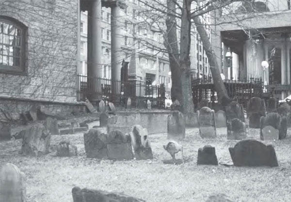
The Granary Burying Ground is one of several cemeteries in Boston to hold the remains of the veterans and leaders of King Philip’s War. (Eric Schultz)
A second important peak in colonial Boston was Sentry Hill, rising 185 feet above sea level. The order to place a beacon on its summit in times of danger eventually gave it a new name, Beacon Hill. At the time of King Philip’s War, notes Boston chronicler Annie Haven Thwing, Beacon Hill was “a grassy hemisphere so steep that one could with difficulty mount its sides.”85 Beacon Hill began to tumble in 1807, when the Mill Pond Corporation began using its soil to fill in Mill Pond.
A third peak, West Hill, together with Sentry and Cotton Hills, made up Boston’s Trimount, a topographical feature captured in the modern-day name, Tremont Street.
Much of Governor Leverett’s Boston was destroyed by two great fires, unrelated to King Philip’s War, in November 1676 and August 1679. The former destroyed the North Meeting House, Increase Mather’s house, and others around North Square.86 The latter fire demolished eighty dwellings and seventy warehouses87 and obliterated so many landmarks that the fixing of the estate boundaries was made difficult. Other fires throughout the years—in 1691, 1702, 1711, 1760 (when 349 buildings were consumed), and 1872—left little of colonial Boston standing. Today, it is believed that no building erected prior to 1676 survives.88
Leverett’s house stood at the south corner of Court and Washington Streets. A portrait of the governor is held by the American Antiquarian Society in Worcester. In 1681 Increase Mather bought a house on the west side of Hanover Street, between Tilesston and North Bennet Streets.89
According to the Memorial History of Boston, the first town house was erected in Boston in 1657, “a very substantial and comely building, sixty-six feet in length, and thirty-six feet in breadth, set upon twenty-one pillars ten feet in height between the pedestal and capital.90 This building was located in the marketplace at the head of State Street.91 It was in these chambers that Governor Leverett and officials from Connecticut and Plymouth Colonies met to issue orders during King Philip’s War. The town house was lost in the fire of 1711. The present “town house” was built in 1713, partially consumed by fire in 1767, and used as the State House until 1798, when it was replaced by the new one on Beacon Street.92
Boston is the final resting place for many important participants in King Philip’s War. Major Thomas Savage is buried in the King’s Chapel yard. He was a tailor by trade and lived near the northerly corner of North and Fleet Streets. Also buried in the King’s Chapel yard are John Winthrop, the governor of Connecticut during the war and the eldest son of the former Massachusetts governor; and Lady Andros, wife of Sir Edmund. John Hull, Massachusetts Bay’s treasurer during the war, is buried at “The Granary,” known in colonial times as the South Burial Ground. The bodies of Captain Thomas Lake (killed by Abenaki at his trading post in present-day Maine) and Major Richard Waldron (killed by Indians in New Hampshire in 1689) are interred at Copp’s Hill Burying Ground.
Captain Cyprian Southack, who fought alongside Benjamin Church, lived at the northern base of Cotton Hill; present-day Howard Street was originally named Southack’s Court after him. Captain Samuel Moseley was born at Braintree but lived with his family on the corner of present-day Union and Hanover Streets.93 Captain Daniel Henchman, severely criticized for his performance in fighting Philip at the Nipsachuck Swamp, lived and taught school in Boston prior to King Philip’s War. His residence was located just north of Copp’s Hill Cemetery, between Commercial Street and Charter Street. In 1674/75 he laid out a cartway ten feet wide, later called Declintion Alley, and today known as Henchman Street.
On the evening of October 30, 1675, a large body of Christian Indians, under suspicion by the English and forced to leave their homes against their will, were met on the Charles River by three vessels and transported to Deer Island in Boston Harbor. At the time of the war, the island—named for the many deer that used it as an escape from wolves on the mainland—was covered by forest and used for the grazing of sheep. The conditions under which these Indians prisoners lived during the war were wretched, and one report indicates that between five hundred and three thousand may have died in captivity.94 The subsequent history of Deer Island is no less glamorous. The island was farmed until 1847, when it was turned into a quarantine station to treat some of the twenty-five thousand newly arrived Irish immigrants. During the nineteenth century it was also used by a dozen city institutions—including a truant school, two “houses of reformation,” and a city almshouse—serving more than three thousand indigent people. In 1896 the Suffolk County House of Correction was opened on the island, joined in the twentieth century by a piggery whose odor sometimes drifted over Boston proper. Structures on the island were finally razed in 1992 to make way for the Massachusetts Water Resource Authority’s sewage treatment plant. No longer an island, Deer Island’s 138 acres are connected by a landfill and road to Winthrop, Massachusetts.
Records indicate that on October 18, 1662, both Canonchet95 and Philip visited Boston Common. The Memorial History of Boston describes the Common in colonial times as an area of “uninclosed waste, the stubbly cow-pasture, the bleak hill-side . . . when the wild roses bloomed upon its summit and the frogs croaked in the marshes at its base.”96 The earliest map of the Common shows only a handful of trees, one being “the Old Elm,” which was thought to be growing before the first English settlement. This elm fell in 1876 and a sprout known as “the old elm’s descendant”97 grew near the same spot. Markers at the base of this second tree once commemorated both:
THE OLD ELM
THIS TREE HAS BEEN STANDING
HERE FOR AN UNKNOWN PERIOD.
IT IS BELIEVED TO HAVE EXISTED
BEFORE THE SETTLEMENT OF BOSTON,
BEING FULL GROWN IN 1722, EXHIBITED
MARKS OF OLD AGE IN 1792,
WAS NEARLY DESTROYED BY A STORM
IN 1832. PROTECTED BY AN IRON
ENCLOSURE IN 1854
J.V.C SMITH, MAYOR
THE OLD ELM
DESTROYED BY A
GALE FEB. 15, 1876
THIS ELM
PLANTED A.D.1876
Today, neither elm nor any marker indicates the spot of these old trees, though a kiosk map at the Common indicates the location where they once stood.
Monoco was executed on September 26, 1676,98 upon the gallows at “the town’s end,” not beyond the present Boylston Street.99 But most of the early executions in Boston took place on “one of the knolls” of the Common,100 possibly near the Old Elm, and the burials were nearby. During King Philip’s War the Common became the site of numerous Indian executions. In July 1676, Matoonas was tied to a tree (the Old Elm?) on the Common and shot for committing the first murder of the war. (Ironically, in June 1656 Matoonas’ father had also been shot on Boston Common.101) About thirty Indian war prisoners were hung there in August 1676. At least fifteen natives were shot or hung on the Common in September 1676 by Chief Marshall Edward Michelson.102
Finally, Boston served as the mustering place for Massachusetts troops in their expedition against the Narragansett in December 1675. About six hundred men were gathered on Dedham Plain, a piece of land abutting the Neponset River that subsequently became Hyde Park and was annexed to Boston. This spot, now covered with homes, was also a mustering place during the Civil War.
John Woodcock’s garrison was situated at an important location on the old colonial road from Boston to Providence. It was used by Captain Samuel Moseley’s troops in June 1675, by Massachusetts Bay troops prior to the Great Swamp Fight in December 1675, by the survivors of Pierce’s Fight in March 1676, and by other troops throughout King Philip’s War. The garrison site today is occupied by a building called the Woodcock Garrison House, located on Route 1A, about four-tenths of a mile south of the North Attleboro–Plainville line. (The building is open one day in May and November and by appointment.) While some local residents believe that the existing building is Woodcock’s original structure built in 1669 (and it is so marked above the door), records and architectural evidence indicate that the present structure was built around 1720 by John Daggett. The old garrison and Daggett’s newer building may have been attached by a two-story addition and operated as an inn by Daggett.103
In 1806 the Steamboat Hotel was constructed by Israel Hatch next to Daggett’s structure directly on the site of the original garrison. In 1894, Attleboro’s Bi-Centennial Anniversary program noted that “the garrison stood one hundred and thirty-six years, and at the end of that time its timber was sound, save where it had been pierced by bullets during King Philip’s War.”104 Local historian John Daggett reported that a relic of the original garrison was preserved by the Massachusetts Historical Society.105 The Old Hatch House burned in 1893 and was itself eventually torn down.106 Ellis and Morris noted that the foundation stones and cellar holes of the original garrison could still be seen in 1906.107

Across Washington Street from Woodcock’s garrison in North Attleboro, Massachusetts, sits a well-preserved colonial graveyard, resting place for some of the English victims of King Philip’s War. (Eric Schultz)
The present-day Woodcock Garrison House, while not a part of King Philip’s War, is significant architecturally as the only known variant of a Rhode Island stone-ender—a frame house with one of the gable ends built mostly of stone or brick—in Massachusetts.108
Across Washington Street from the garrison, at the intersection of Routes 1 and 1A, is the Woodcock Historic Burial Ground (also called the Old North Burying Ground, 1776), the oldest burying spot in town. John Woodcock’s son, Nathaniel, was shot by Indians here in April 1676 and was buried where he fell. A 1694 deed to the Woodcock property mentions this spot: “Except a small parcel of at least six rods square or the contents thereof, for a burying place, in which my wife and several of my children and neighbors are interred.”109 These graves are said to be situated in the center of the present cemetery in an area unmarked by any stones. In all, there are 112 stones in the cemetery.
John Woodcock, an “implacable enemy of the Indians,” was sentenced on March 6, 1654/55, to sit in the stocks and fined forty shillings for going into an Indian’s house and stealing some property and kidnapping a child as payment for a debt he believed the native owed him.110 When Woodcock died in October 1701, it was reported that he had the scars of seven bullet holes on his body.111
At the time of King Philip’s War, Native Americans had been living on the land around Middleboro for perhaps twelve thousand years.112 The Wampanoag village settled at the time of the war was known as Nemasket, located about one and one-half miles southeast of the present-day center of Middleboro.113 Not far away, on present-day Main Street at the Nemasket River, the so-called Wading Place is commemorated by a state marker that reads:
THE WADING PLACE
SITE OF THE FORD OF WADING
PLACE WHERE THE INDIAN TRAIL
FROM PLYMOUTH TO “MIDDLEBERRY”
(MIDDLEBOROUGH) CROSSED THE
NEMASKET RIVER. WHEN THE
TOWN WAS ESTABLISHED IN 1669, ITS
SOUTHERN BOUNDARY WAS
DESCRIBED AS EXTENDING “SIX MILES
FROM THE WADING PLACE.”

“Hand rock,” located on Barden Hill in Middleboro, Massachusetts, is the stuff of legend: The handprint on the rock is said to be that of the Wampanoag who fell victim to John Thomson’s long gun in June 1675. (Eric Schultz)
The sachem of the Nemasket, Tispaquin (the “Black Sachem”), was Philip’s brother-in-law and trusted friend who led attacks throughout the war on Bridgewater, Plymouth, and Scituate. Tispaquin’s wife and children were captured and taken to Plymouth by Benjamin Church in September 1676. Church, who referred to the sachem as “a great Captain,”114 left word that if Tispaquin would surrender, he and his men would be enlisted to fight with Church in the continuing war in Maine. A few days later Tispaquin surrendered in Church’s absence. He was immediately sent to Plymouth and shot. William Hubbard refers to this episode as a trap set by Church whereby Tispaquin “received the just reward of his former wickedness.”115 Other historians believed Church was sincere, and Plymouth authorities either acted without knowledge of Church’s promise, or more likely, acted in bad faith.116 Church himself wrote that when he “returned from Boston, he found, to his grief, the heads of Annawon, Tispaquin, etc., cut off where were the last of Philip’s friends.”117 The nineteenth-century antiquarian Samuel Drake, who did extensive research on King Philip’s War, called the act “barbarous.”118 Middleboro historian Thomas Weston felt that “this action on the part of the governor and council has led to perhaps more severe criticism than any portion of the public administration at New Plymouth.”119
The authorities at Plymouth had first purchased land at Nemasket from the Wampanoag in 1661120 and granted the new area township status in 1669, when it changed its name from Namassakett to Middleberry. Over the next six years Middleboro grew to about seventy-five residents121 scattered across a sprawling settlement bounded by Plymouth, Taunton, and Bridgewater.122 Because of the close proximity of Wampanoag and English, and the nearness of both to Plymouth and Mount Hope, each sensed trouble brewing long before the outbreak of violence in Swansea.
Shortly after incorporation of the town in 1669, Middleboro inhabitants built a fort on the western bank of the Nemasket River near the Wading Place. The Old Fort is commemorated by a state marker on Route 105, nine-tenths of a mile north from the intersection of Route 28, in front of the Middleboro Memorial Junior High School. The marker reads:
OLD FORT
FIFTY RODS EAST IS THE SITE
OF THE OLD FORT, BUILT ABOUT 1670
AS A PLACE OF DEFENSE AND REFUGE
IN TIME OF NEED. DURING KING
PHILIP’S WAR, AN INDIAN MAKING
INSULTING GESTURES ON INDIAN ROCK,
ACROSS THE NEMASKET RIVER, WAS
SHOT FROM THE FORT.
The fort is thought to have been on or near the baseball field behind the junior high school; a rock near the field is used as a landmark. From here, one stands on a bluff that commands a view of the Nemasket River and the Wading Place trail. While no description of the fort remains, it was large enough to accommodate all seventy-five residents of Middleboro for six weeks.123 The fort was never attacked but was burned to the ground by Wampanoag after the abandonment of Middleboro.
The first attack on Middleboro was on July 9, 1675. John Thomson124 (sometimes spelled Tomson, later Thompson), commander of the Middleboro fort and its sixteen militiamen, wrote to Governor Winslow afterward that his men were not strong enough to take the raiders head-on, and had to watch as the town was set on fire. Thomson reported that “towards night they [the Wampanoag] returned to the top of Tispaquin’s Hill with great triumph and rejoicing, with a shout. But we firing our long gun at them, they speedily went away.”125
The long gun used to frighten the Wampanoag from Tispaquin’s Hill is today known as the Thomson Gun and resides in the collection of the Old Colony Historical Society in Taunton, Massachusetts. The story that brought the gun its fame has more than one version. In 1675, when Thomson was made commander of the Middleboro fort, he required that each of his militiamen bring an ordinary gun for defense. In addition, Thomson bought his long gun, weighing twenty pounds, twelve ounces, and measuring a full seven feet, four and one-half inches long.126
In early June 1675 a band of warriors appeared on the opposite side of the Nemasket River, on a hillside (Barden Hill) near the so-called hand rock, notable for its impression of a man’s hand. For several days the Wampanoag flung insults across the water until finally the English decided to respond. Isaac Howland, known for his marksmanship, was selected to fire the long gun. Some versions of the story say that he was to scare the warriors, and others claim that he was to kill one as a warning to the other Wampanoag.127 In any event, no one expected much more than a startled reaction from the warriors since the distance from the fort to the Wampanoag was 155 rods, or about half a mile.128 Much to everyone’s surprise, one of the natives fell mortally wounded.129 (Legend says it is his handprint on the rock.) He was carried about three miles distant and buried by his comrades. In 1821, according to tradition, a Major Thomas Bennett was ploughing his land and accidentally unearthed the bones, pipe, stone jug, and knife of the Wampanoag killed by the Thomson gun.130
The “hand rock” can still be seen today,131 its handprint clearly visible despite vandalism.
John Thomson’s home (in present-day Halifax, Massachusetts) was destroyed during the attack on Middleboro. The site is marked by a plaque set on an original hearthstone from the house. The plaque is located on Route 105 (Thompson Street) about one mile north of the Middleboro line and fifty yards east of the road.
Thomson is buried in the Nemasket Hill Cemetery; his original gravestone has been replaced by a granite marker. Isaac Howland is buried in the Middleboro Church of the Green Cemetery on Route 105.
The night that John Thomson’s house was burned, Thomson stopped to warn George Danson of the attack. Danson either waited until the next morning132 or proceeded to safety that night with something less than due haste. When he stopped to let his horse drink at a brook, tradition indicates that Danson was shot by a Wampanoag.133 The site of his alleged death is at present-day Thompson Street in Middleboro, near the Halifax line, at a brook now bearing his name.
Old Dartmouth included New Bedford, which was established in 1787, and Fairhaven, established from New Bedford in 1812. Nearly all the dwellings of the English at Old Dartmouth were reduced to ashes in the July 1675 attack. Those garrisons that survived were occupied only long enough to allow the settlers to escape to safer communities. Once abandoned, the remaining settlement was completely destroyed by the Wampanoag.
Totoson was sachem of the Mattapoisett and one of Philip’s principal lieutenants during the war. He led the July 1675 attack on Old Dartmouth (that allowed Philip to flee the Mount Hope peninsula) as well as the devastating raid on Clark’s garrison in Plymouth later, in 1676. Historians believe that Totoson’s main camp was located in present-day Mattapoisett, as described by Samuel Drake in 1829,
on the left of the main road as you pass from the village of Rochester to Mattapoisett, and about two miles from the latter. It was a piece of high ground in a large swamp, connected to the high land by a narrow neck, over which, all had to pass to visit him. The road passes near where this neck joins the high ground.134
Today, this main road is no longer used, having given way to the higher ground along where present-day North Street runs. However, Totoson and his camp are not forgotten. His name was corrupted by the English to Tousand, and eventually Towser,135 and thus he is the namesake for Towser’s Neck Road. This overgrown trail cuts between Haskell Swamp and Towsers Swamp, east of North Street and north of Tinkham Hill, and represents the remnants of the former main road. Towser’s Neck Road, which runs on private property and is difficult to reach, eventually passes the highland location of Totoson’s camp.
Totoson was never captured by the English, escaping several times from Benjamin Church and once nearly killing him. Shortly before the death of Philip, Church captured most of Totoson’s remaining company. Totoson and his young son escaped and made their way to present-day Wareham,136 where the son fell ill and died. Totoson died soon after, possibly succumbing to the same sickness as his son, though Church ascribes his death to a broken heart:
The wretch reflecting upon the miserable condition he had brought himself into, his heart became a stone within him, and [he] died. The old squaw flung a few leaves and brush over him, came into Sandwich, and gave this account of his death; and offered to show them where she left the body; but never had the opportunity, for she immediately fell sick and died also.137
John Cooke’s garrison stood several miles from Totoson’s camp in present-day Fairhaven.138 The site is marked by a bronze tablet set into stone that stands on the north side of Coggeshall Street, just west of Garrison Street. The marker reads:
THIS BOULDER
MARKS THE SPOT WHERE BARRACKS
WERE PLACED FOR THE PURPOSE OF
PROTECTING THE EARLY INHABITANTS
DURING THE INDIAN WARS
THESE BARRACKS WERE ERECTED BY
JOHN COOKE
THE LAST SURVIVING PILGRIM OF THOSE
WHO CAME OVER IN THE MAYFLOWER
AND THE FIRST WHITE MAN TO SETTLE
IN THIS TOWN.
An 1899 history of Bristol County noted that the Cooke garrison walls “were in good preservation until recent times,”139 though nothing remains today. A 1904 paper written for the Old Dartmouth Historical Society noted that “among the relics preserved in the rooms of our society are various arrowheads, spoons and cooking utensils dug up on the site of Cooke’s garrison.”140 John Cooke’s burial spot is marked not far away, on Pilgrim Avenue, west of Main Street in a small park overlooking the Acushnet River and New Bedford Harbor.
Jacob Mitchell and his wife, who resided in present-day Fairhaven south of Spring Street near the current Boys’ Club, were killed as they fled to the Cooke garrison.141 Thomas Pope and his wife, also fleeing to the Cooke garrison from their house and mill on Sconicut Neck, were killed at a location west of present-day Walnut Street on the south side of Spring Street.142
In 1907 Franklyn Howland recorded that the Wampanoag remaining in Fairhaven after King Philip’s War were confined to a reservation “of about one acre located on the west side of the road on Sconicut neck, Fairhaven, about a quarter mile south of the present chapel.”143 The burying ground of these Wampanoag was located on the east side of Sconicut Road, about one-and-one-quarter miles south of Route 6, close to the shore. “At one time beneath a solitary clump of oaks, which had been sacredly preserved, were a number of headstones,” according to Howland. “But the oaks have been cut down; the stones have been removed; the mounds have been leveled, and all traces of this hallowed spot have disappeared.”144
An Old Dartmouth garrison owned by John Russell was situated in the Apponogansett area of present-day South Dartmouth. The foundation of the Russell garrison is still visible, though briars and bramble have grown around the site. A tablet nearby reads:
THE RUSSELL GARRISON
A PLACE OF REFUGE FOR THE
EARLY SETTLERS OF DARTMOUTH DURING
KING PHILIP’S WAR
1675–1676
FOUNDATION REGISTERED BY THE
OLD DARTMOUTH HISTORICAL SOCIETY
1951
The Russell garrison can be reached on Apponogansett Bay in South Dartmouth by taking Elm Street to Lucy Street to Fort Street. Directly across the bay from the Russell garrison was a Wampanoag village called Indian Town, from which the natives
used to show themselves, and act all manner of mockery, to aggravate the English; they being at more than a common gunshot off. At one time one made his appearance, and turned his backside in defiance, as usual; but some one having an uncommonly long gun fired upon him and put an end to his mimickry.145
A garrison was also situated on Palmer’s Island on the Acushnet River, though no remains are evident on this heavily built land now connected by bridges along Route 6.
Benjamin Church conducted many of his field operations in and around Old Dartmouth and the adjacent towns comprising Old Rochester. Undoubtedly one of Church’s more pleasant wartime experiences occurred in the summer of 1676, after he had convinced Awashonks and her Sakonnet to join the side of the English. Returning from Plymouth with a new commission to lead the Sakonnet, Church was supposed to meet the natives at Sandwich, Massachusetts. When he arrived he found that the Wampanoag had already departed. Church caught a quick night’s sleep and left the following morning with sixteen or eighteen men in search of his new troops. Church described his movements as follows:
He proceeded as far as Agawom, where they had great expectation of meeting the Indians, but met them not. His men being discouraged, about half of them returned. . . . When they came to the Sippican river, Mr. Howland began to tire, upon which Mr. Church left him and two more, for a reserve, at the river. . . . Proceeding in their march, they crossed another river, and opened a great bay, where they might see many miles along shore, where were sand and flats; and hearing a great noise below them, towards the sea, they dismounted their horses; left them, and creeped among the bushes, until they came near the bank, and saw a vast company of Indians, of all ages and sexes; some on horseback running races; some at football; some catching eels and flat fish in the water; some clamming, etc.146
Discovering this group to be Awashonks and her Sakonnet, Church soon joined them, feasting on “a curious young bass in one dish; eels and flat fish in a second; and shell fish in a third.”147 After dinner, a huge bonfire of pine was lit, and the mixed group danced around as a sign that “now they were all engaged to fight for the English.”148
Historians do not know the precise location of this colorful affair. Henry Martyn Dexter suggests that the second river Church crossed was Mill Creek, flowing into Aucoot Cove. Church’s report of a “wide view of the bay” might indicate that the location of Awashonks’ celebration was between Angelica and Ned Points, or between Aucoot Cove and Angelica Point in present-day Mattapoisett.149
In 1984, Maurice Robbins of the Massachusetts Archaeological Society published The Sandwich Path: Church Searches for Awashonks, in which he attempted to re-create the likely path taken by Church. Robbins noted that the construction of the Cape Cod Canal in 1914 had eliminated the Scusset and Monomet Rivers, destroyed a large Wampanoag village near the Herring River, wiped away the nearby system of roads and paths,150 and made the precise re-creation of the first segment of Church’s journey impossible. However, once away from the canal, Robbins picked up the chase along Bournedale Road to the Head of Bay Road, into Wareham on Red Brook Road, passing along Route 6 to Elm Street. From there, Church may have followed Main Street to Fearing Hill Road and crossed the Weweantic River just north of Horseshoe Pond. Following Mary’s Pond Road into Rochester, Church detoured south just past Mary’s Pond itself to escape the wetlands where the current road ends, picking up Mary’s Pond Road again near the southern tip of Leonard’s Pond. From there, the path passed the Rochester Common, heading west on New Bedford Road, crossing into Acushnet on Perry Hill Road, and fording the Sippican River on the Hiller Farm. Church continued through Acushnet west across the Mattapoisett River to Mendall Road, south on Hathaway Road to South Main Street, and into Fairhaven, where Alden Street leads most directly to Pope Beach. It is here, after a march of about twenty-six miles from Sandwich, that Robbins believes Church found Awashonks and her Sakonnet.151 This site is considerably farther west than Dexter’s location, and given the century of archaeological discovery between Dexter and Robbins, probably more plausible.
Benjamin Church’s adventure in July 1675 on Punkatees Neck convinced the English that Philip had escaped the Mount Hope peninsula and was coordinating battle plans from the Pocasset side of Mount Hope Bay (now Tiverton, Rhode Island, and Fall River, Massachusetts). With that in mind officials ordered Massachusetts Bay troops returning from Narragansett country to march to Taunton, where on July 18, 1675, they were joined by Plymouth forces under Major James Cudworth. From there, the combined army marched eighteen miles to the “great swamp on Pocasset,”152 thought by contemporaries to be a single swamp seven miles in length. On July 19 Massachusetts and Plymouth forces entered this thick bramble and engaged Philip’s band. Five English were killed and seven wounded, several mortally. All day the English advanced and the Wampanoag fought a spirited rear-guard action. When darkness approached the exhausted English retreated from the thick undergrowth. Captain James Cudworth wrote the following account to Governor Winslow on July 20 from the garrison on Mount Hope:

While no one can be sure of the precise location of the Pocasset Swamp Fight, this early-twentieth-century photograph of Pocasset country gives a better sense of the area’s terrain than the well-developed business and residential neighborhoods of today’s Fall River, Massachusetts, and Tiverton, Rhode Island. (From King Philip’s War, George W. Ellis and John E. Morris, 1906)
On Monday [July 19] following we went to see if we could discover Philip, the Bay forces being now with us; and in our march, two miles before we came to the place of rendezvous, the captain of the Forlorn was shot down dead; three more were then killed or died that night, and five or six more dangerously wounded. The place we found was a hideous dismal swamp [Pocasset Cedar Swamp]; the house or shelter, they had to lodge in, contained, in space, the quantity of four acres of ground, standing thick together; but all women and children fled, only one old man, that we took there, who said, Wittoma was there that day, and that Philip had been there the day before, and that Philip’s place of residence was about half a mile off; which we could made no discovery of, because the day was spent, and we having dead men and wounded men to draw off.153
In all, seven or eight English lay dead with little to show for their efforts, prompting the Reverend William Hubbard to conclude that “it is ill fighting with a wild beast in his den.”154 Cudworth concurred, writing:
Now so it is, that we judge it now our work to assault him at such disadvantages; for the issue of such a design will be to pick off our men, and we shall never be able to obtain our end in this way, for they fly before us, from one swamp to another.155
The exact site of the Pocasset Swamp Fight is unknown and subject to much conjecture. Historians believe Philip probably joined with Weetamoe and her Pocasset at or near the squaw sachem’s camp, which historian Henry Martyn Dexter thought to be on the southern side of the present-day Pocasset Cedar Swamp, between South Watuppa Pond and “heights which look down on Mount-Hope Bay.”156 Writing a decade after Dexter, Ebenezer Peirce described the camp as being farther south on Nannaquaket Neck157 “on a hill not far from the shore.”158 Peirce added that in 1878 he
rode to the stone Bridge in Tiverton, where I made inquiries of the oldest inhabitants, who agree with me that the place seems most probable to have been occupied by King Philip and his followers is the low grounds next to the Taunton River, about a quarter of a mile from the present line that divides Fall River, Mass., from Tiverton, R.I., and on the Tiverton side of that line. The railroad from Fall River to Newport runs directly through this tract, as does also a turn-pike road that used to connect Fall River with the settlement at Howlands’ Ferry Bridge in Tiverton.159
In a history of Tiverton published in 1976, the author placed Philip and Weetamoe’s initial hiding spot “in the woods between the Sucker Brook and what is known as the Bear’s Den, east of the present Fish Road.”160
Some of the difference in opinion regarding the location of Philip and Weetamoe’s rendezvous point is undoubtedly due to the fact that they were in constant motion from the moment Philip bolted from the Pocasset peninsula. The two may well have occupied several sites on their journey from Tiverton to the Taunton River. Most of their march would today be obscured by the asphalt and concrete that make up urban sections of North Tiverton and Fall River. That leaves historians to speculate based on the historical record, which in itself poses problems. The area known today as the Pocasset Cedar Swamp is perhaps three-quarters of a mile long at its greatest span. This is far less than the seven miles reported by contemporary historians. Several miles of unconnected swampland run south from the Pocasset Cedar Swamp through Tiverton, though most historians place Philip and Weetamoe farther north at the time of the battle, with little inclination to march south.
Consequently, more modern writers such as George Ellis and John Morris conclude that the seven-mile swamp where the battle was said to occur “was rather a thick growth of woods and tangled underbrush than a wet and miry lowland”161 stretching north from Pocasset Cedar Swamp into Fall River and then along the Taunton River. In Fall River in History, published in 1930, the Tercentenary Committee of Fall River located the Pocasset Swamp Fight “in the southeastern part of our city, the Peasefield district, probably Maplewood.”162 Ellis and Morris, writing in 1906, determined a location for the fight farther north:
There is evidence that the encounter was a point on the eastern shore of the Taunton River directly opposite the present village of Somerset, between the Assonet River and the railroad track leading to Middleboro, and hemmed in on the east by the highway from Fall River to Assonet village. This section of country is rolling, watered by several streams, with occasional marshes.163
This location, about two miles north of the Pocasset Cedar Swamp, would put Philip and his followers near a convenient fording spot across the Taunton River. This location corresponds with Peirce’s findings and with Hubbard’s assertion that “the swamp where they would lodge begins not far from the arm of the sea, coming up to Taunton, they taking the advantage of a low tide, either waded over one night in the end of July, or else wafted themselves over upon small rafts.”164 However, Ellis and Morris do not present any additional evidence used to determine this location. Samuel Drake, careful about pinpointing locations associated with the war, wrote only that the swamp fight’s “exact locality is not pointed out.”165
In summary, we are left to speculate on Philip and Weetamoe’s exact route. We know that they fled north in hope of crossing the Taunton River, and that the English ended the chase still in unfriendly terrain they referred to as swamp. We also know that, whatever their route, the Wampanoag used the natural terrain of Tiverton and Fall River to their best advantage, inflicting real and psychological wounds on the English. This second escape from the colonial noose meant that the war would expand to all of New England and that all thoughts of a quick capture of Philip were ended.
The William Clark garrison was located on the Eel River, three miles southeast of Plymouth.166 On March 12, 1676, the house was attacked while many of the men were at a meeting in Plymouth. Eleven women and children from two families were killed and the garrison burned to the ground. Totoson led this lightning attack.167 One of the Clark sons was wounded by a tomahawk during the fight, but recovered and had a silver plate fastened to his head to protect the wound. He was called “Silverheaded Tom” for the rest of his life.168
Henry Martyn Dexter described the Clark garrison as being situated about three miles southeast from the village of Plymouth, on the west bank of the Eel River, almost against the point of junction of Plymouth Beach with the mainland and perhaps three-quarters of a mile inland from the junction; the nineteenth-century home of the Reverend Benjamin Whitmore was said to be very near the former garrison site.169 George Ellis and John Morris described the garrison in the same location, being “half a mile to the eastward of the village of Chiltonville on a site occupied by [the Whitmore house],” built about 1826.170 This is, however, another case of past antiquarians being more assured than modern historians and archaeologists. The staff at Plimoth Plantation will explain that the precise site of the Clark garrison is unknown; no remains have ever been located. Some believe that the garrison may have been located near what is now the parking area for the Wampanoag Summer Campsite at Plimoth Plantation (see below).171
There are several other sites in Plymouth related to activities during King Philip’s War. The town’s famous Burial Hill was first called Fort Hill, the site of Plymouth’s Fort Meeting House during the war. The location of the fort is marked by a sign that reads:
SITE OF THE
FIRST FORT
BUILT IN 1621
LOWER PART USED FOR CHURCH
ALSO SITE OF THE FORT
BUILT IN 1675
WHICH WAS 100 FT SQ SIDES 10 1/2 FT HIGH
On February 19, 1675, the town voted to fortify this structure by building a square palisade, ten feet high and one hundred feet on each side. Each man in town was required to build a three-foot section of it.172 It was on this palisade that Philip’s head was set after his death.173 The fort on Burial Hill was abandoned as a defense in 1677. A visitor in 1807 discovered the remains of the ditch that surrounded the fortification,174 though nothing of the fort can be seen today.
Material from the fort was sold to William Harlow for a house now known as the Harlow Old Fort House. Built in 1677, the Harlow House is a working museum that offers a glimpse of colonial life around the time of King Philip’s War through daily demonstrations of household arts. The Harlow House is located on Sandwich Street across from the fire station.
The Jabez Howland House, built in 1666, is reported to be “the last house left in Plymouth whose walls have heard the voices of Mayflower Pilgrims.” The house is located on the corner of Sandwich and Water Streets. Jabez Howland, son of John and Elizabeth (Tilley) Howland, fought under Benjamin Church and is mentioned often in Church’s narrative of King Philip’s War.
Among the antiquities preserved at the Pilgrim Hall Museum at 75 Court Street is the gun barrel with which Philip was killed; a leather pocketbook, a pair of spectacles, and a brick from the house of Benjamin Church; and many Winslow artifacts, including Josiah’s portrait, baby shoes, and various household items. There are many Wampanoag artifacts in the museum as well. These items are often in storage, so special plans must be made to view them.
The Wampanoag Summer Campsite, off Route 3 at Plimoth Plantation, re-creates Hobbamock’s Homesite, the village of a Pokanoket Indian who provided counsel to the Pilgrims. In 1995, an exhibit at Plimoth Plantation called Irreconcilable Differences: 1620–1692 painted the tense, often violent world of the Wampanoag and Pilgrim, including the attack on Clark’s garrison.
Tispaquin and a small party of Wampanoag attacked the old settlement of Bridgewater, present-day West Bridgewater, on April 9, 1676, burning a house and a barn in the east end of town. The town’s minister, the Reverend James Keith, described the assault in a letter to the assistant governor of Plymouth, ending with the fears of the townsmen: “We are in expectation every day of an assault here. The Lord prepare us for our trial.”175

Dating to 1662 and shown here circa 1906, the home of Reverend James Keith, Bridgewater, Massachusetts’ first minister, is still standing on River Street in West Bridgewater. A court case in 1818 proved conclusively that Keith lived and died in this house, which is today owned by the Old Bridgewater Historical Society. (From King Philip’s War, George W. Ellis and John E. Morris, 1906)
On Monday, May 8, that assault came when Tispaquin led about three hundred natives in an attack on the settlement. Tradition holds that the warriors set fire to some buildings on “the east side of the village on the south side of the river,”176 but a torrential downpour extinguished the flames. When Tispaquin and his men renewed their assault on the north side of the river, the residents were able to drive them away without loss.177 In fact, during all of King Philip’s War, not one of the inhabitants of Bridgewater was killed.178
The house of the Reverend James Keith, a Scottish immigrant and the first minister of Bridgewater, is still standing on River Street in West Bridgewater. The house dates to 1662, having undergone enlargements in 1678 and again in 1837. William Latham’s Epitaphs in Old Bridgewater presents pictures of the house in each of its three stages, and relates a court case tried in 1818–1819 in which it was necessary to prove conclusively that Keith lived and died in this house.179 Today, Keith’s house is owned by the Old Bridgewater Historical Society, which opens it to the general public occasionally and also by appointment.180
Keith played a small but important part in King Philip’s War. In September 1676, after Philip’s death, colonial officials debated what sentence should be handed down to Philip’s wife and nine-year-old son. The question of whether Philip’s son should be put to death was especially troublesome, and so was turned over to the clergy. The ministers Samuel Arnold and John Cotton looked to Deuteronomy 24:16 for guidance—“Fathers shall not be put to death for their children, nor children put to death for their fathers; each is to die for his own sin”—but decided that Scripture did not apply if the crime was committed by “notorious traitors, rebels, and murderers, especially of such as have bin principal leaders and actors in such horrid villainies.”181 Bending Scripture to their purpose, Arnold and Cotton voted for death. Increase Mather concurred when he compared Philip’s son to Hadad, who lived after his father’s death and proved to be a “scourge to the next generation.”182
Keith took an opposite view and wrote persuasively that, despite Psalms 137:8–9 (“Happy is he who repays you for what you have done to us—he who seizes your infants and dashes them against the rocks”), Deuteronomy 24:16 should be a guide. His opinion evidently carried great weight, for the last we hear of Philip’s son is on March 20, 1677, when John Cotton wrote to his brother, “Philip’s boy goes now to be sold.”183
Keith and his wife are buried in the Old Graveyard at West Bridgewater on the east side of South Street. Their gravestone reads:
In early August 1676, Weetamoe, accompanied by about twenty-six warriors—from a number that had once been as high as three hundred184—took refuge in a dense swamp near Taunton, Massachusetts. Perhaps she was attempting to reach Philip, or seeking safety in Narragansett country, or was simply unsure what her next move should be.
On August 6, a party of twenty men from Taunton, led by an Indian who had crossed over to the English side,185 surprised and captured the band. Weetamoe escaped and attempted to cross the Taunton River, in Hubbard’s words, “upon a raft or some pieces of broken Wood; but whether tired or spent with swimming, or starved with cold and hunger, she was found stark naked in Metapoiset, not far from the waterside.”186
Weetamoe’s corpse was mutilated and her decapitated head sent to Taunton, where it was placed on a pole, paraded through the streets of Taunton, and left on public display at the Taunton Green. Increase Mather described the scene: “The Indians who were prisoners there knew it presently, and made a most horrid and diabolical lamentation, crying out that it was their Queen’s head.”187
Both Hubbard and Mather state that Weetamoe’s body was discovered at Metapoiset,188 then a part of Swansea and now Somerset, Massachusetts. Recent tradition holds that her body was discovered near the present-day Weetamoo Street, north of the Brightman Street Bridge in Fall River, Massachusetts.189 Ebenezer Peirce reported in 1878 that

Samuel Drake visited Anawan Rock, making (in his own words) “a rude sketch of the place, which was engraved upon a copper plate for my edition of Church’s History.” (Courtesy of the Haffenreffer Museum of Anthropology, Brown University)
in the city of Fall River, near the shore of Taunton River in which Weetamoo perished, stands a large cotton factory, named in honor of this unfortunate American queen. It was near the site of the Weetamoo Mill that her dead body was washed ashore, and mutilated by professed Christians in brutal triumph.190
One modern author even fixes her point of departure near the Slades Ferry Bridge in Somerset.191 None of these latter reports are reliable; the early records indicate that Weetamoe’s body was discovered on the west side of the Taunton River. By standing at Slades Ferry and looking north along the river to the Brightman Street Bridge, however, one still has a sense of just how long and treacherous this quarter-mile swim would have been.
Perhaps no site related to King Philip’s War has been visited by as many people as Anawan Rock, located about a hundred yards south of Route 44 at Rehoboth, six-tenths of a mile west from the intersection of New Street. A small dirt parking lot leads to a footpath by which the rock is found. A sign in the lot reads:
ANAWAN ROCK
1676
SITE OF THE CAPTURE OF WAMPANOAG
INDIAN CHIEF ANAWAN BY CAPTAIN
BENJAMIN CHURCH ON AUG. 28, 1676
THUS ENDING KING PHILIP’S WAR.
The story of Anawan Rock begins with Philip’s death on August 12, 1676, after which colonial troops began relentlessly hunting down the remaining bands of Algonquian hidden in the woods of Plymouth and Massachusetts Bay Colonies. One of the most sought-after native leaders was Anawan, described by Church as a “great soldier . . . a valiant Captain under Asuhmequin [Massasoit] . . . and Philip’s chieftain all this war.”192 Anawan was said to be quite old at the time of King Philip’s War, though his spirit and vigor remained unquestioned. When Philip’s camp was attacked in Bristol, Anawan “hallooed with a loud voice, and often called out, ‘Iootash, Iootash,’ ”193 according to Church, which meant to “stand to it, and fight stoutly.”194 Anawan was shrewd enough to escape the scene of Philip’s death, and made his way with the remnants of Philip’s people—perhaps fifty or sixty in all195—to a camp in the southeasterly part of present-day Rehoboth. This site, protected on three sides by the Squannakonk Swamp,196 had as its northern boundary an imposing rock, down which any intruder would have to scale to gain surprise entry to the camp.
Captain Benjamin Church had returned to Plymouth after the death of Philip, but was summoned to Rehoboth when news was received that Anawan and his company had been spotted “ranging about their woods.”198 After capturing a number of Wampanoag, Church eventually learned the exact whereabouts of Anawan. Led by one of Anawan’s own men, Church moved quickly on Monday, August 28, to capture the chief who “never roosted twice in a place,”199 Church believed, and who “often said, that he would never be taken alive by the English.”200 Church, through his son Thomas, wrote a firsthand account of Anawan’s capture destined to immortalize not only Church but Anawan Rock as well:
The old man had given Captain Church a description of the place where Annawon now lay, and of the difficulty of getting at him. Being sensible that they were pretty near them, with two of his Indians he creeps to the edge of the rocks, from whence he could see their camps.
He saw three companies of Indians at a little distance from each other, being easy to be discovered by the light of their fires. He saw also the great Annawon and his company, who had formed his camp or kenneling place by felling a tree under the side of the great clefts of rocks, and setting a row of birch bushes up against it; where he himself and his son and some of his chiefs had taken up their lodgings . . .
The rocks were so steep that it was impossible to get down, but as they lowered themselves by the boughs and the bushes that grew in the cracks of the rocks.
Captain Church, creeping back again to the old man, asked him if there were no possibility of getting at them some other way? He answered, no, that he and all that belonged to Annawon were ordered to come that way, and none could come any other way without difficulty or danger of being shot.
Captain Church then ordered the old man and his daughter to go down foremost, with their baskets at their backs, so that when Annawon saw them with their baskets, he should not mistrust the intrigue. Captain Church and his handful of soldiers crept down also, under the shadow of those two and their baskets.201
Church captured Anawan and his band, secured their weapons, and then shared a meal with the aged chief. In William Hubbard’s version of events, published in 1677, Anawan confessed to a number of crimes against the English, which would help to justify his execution a short time later in Plymouth. However, Church’s firsthand account fails to mention any confession, showing instead the respect and admiration each man had for the other.
The nineteenth-century antiquarian Samuel Drake visited the site of Anawan’s capture in 1826,202 the same year that the Taunton-Providence turnpike (now Route 44) was begun. (In Church’s time, the path closest to Anawan Rock would have been a trail near the east flank of Great Meadow Hill, half a mile north of the rock, and a difficult march through unbroken woods.203) Drake described the rock in some detail, noting that the road passed within about forty yards of the rock, which extended northeast and southwest seventy or eighty feet. The rock’s “southwest side hangs over a little, and the other, on the northeast part, seems in no very distant period, to have tumbled down in large clefts.” He also remarked that “the northwest side of the rock is easily ascended, as it gradually slopes away from its summit to its base, and at an angle, perhaps, not exceeding 35 degrees.” Drake also found, near the rock’s southwest extremity, “an opening of an angular form, in which, it is said, Annawon and the other chiefs were encamped.”204
Ten years later Leonard Bliss Jr., in History of Rehoboth, described Anawan Rock in a way that so closely resembled Drake’s description that it seems evident he was quoting from Drake’s work.205 Anawan Rock, Bliss wrote, was “a few rods south of the new turnpike from Taunton to Providence . . . on the northern border of a great swamp . . . this side can be seen from the turnpike, and is easily ascended.” Bliss, however, placed the “opening of an angular form,” Anawan’s camping spot, on the rock’s southeast extremity. “In one of the perpendicular sides of this opening is an excavation or fissure, narrow at the bottom and widening gradually upwards, and commencing so near the ground as to make a very convenient seat. This is called ‘Anawan’s chair’; for it is said that in this is where Anawan used to sit.” Within this angular opening there once stood a tree, blown down in the “September gale” of 1815, that “was covered for several feet from the ground with the names of many whom had visited the rock.”206
Both Drake and Bliss agreed on the site, placement, and general description of Anawan Rock. Their disagreement over the position of the fissure seems odd, since Drake described it correctly as being on the southwest side of the rock, and Bliss seemed to be working from Drake’s description. It is clear, however, that they were both describing the same rock, one generally held by their counterparts to be Anawan Rock.
Henry Martyn Dexter visited Anawan Rock some thirty years after Bliss, around 1865, and his description noted how the construction of present-day Route 44 “through the northern end of the swamp, with the natural change of years, has made the position more accessible than of old.” Dexter reported the existence of a tree, “larger than any near it, which bears the marks of being often used as a hitching-post,” a bit northwest of the rock. He relied on “a continuous tradition,” a deep recess along the rock’s southern face, “which answers well to Church’s description of the spot in which Annawon was . . . encamped,” and the site’s protected nature to conclude that this was, indeed, the site of Anawan’s camp.207
Another local historian, Ebenezer Peirce, visited Anawan Rock about 1858, and again in 1878 when he wrote his Indian History, Biography and Genealogy. He described the rock in the same terms as Drake, Bliss, and Dexter, probably referring to the writings of one or more of them. However, after comparing Anawan Rock to Church’s writings, Peirce expresses considerable disappointment “to find so few evidences of the natural difficulties complained of by Capt. Church in getting from its top to the camping place of Annawon.”208 Peirce wrote:
I am nineteen years older than Capt. Church was when he performed his feat that has been wondered at and applauded for more than two hundred years, and in that nineteen years I have grown, as Church would express it, “ancient and heavy” as well as clumsy; he had two strong arms and two very active hands, which I have but one arm, and one hand and that an awkward left one; and yet I passed down the rock and passed up again without the aid of boughs or bushes, and in fact experienced less difficulty in doing so than in getting over many an ordinary stone wall.209
Most recently, local historian Bob Sharples has taken the accounts of Drake, Bliss, and Peirce to question whether the rock they described in the nineteenth century is the same one known today as Anawan Rock, and if that rock is the same one described by Church more than three hundred years ago. On all accounts there appear to be small discrepancies. Sharples notes, for example, that Anawan Rock is over twice as far from Route 44, and nearly twice as long as the seventy or eighty feet described by the three historians; in addition, Sharples adds, it “displays no evidence to support an 1836 account telling about pieces of the rock breaking away and tumbling down the northeast side.”210
As for Church’s description, Sharples finds, like Peirce, that Anawan Rock is less difficult to ascend or descend than he had envisioned. In addition, Sharples writes, “Standing on the great rock I could not imagine 70 or 80 Indian Braves camping and cooking as mentioned in Benjamin Church’s account. I couldn’t imagine them in that wet, mosquito infested swamp, the terrain I encountered when I viewed the site.”211
With these issues in mind, Sharples investigated the area around the place known as Anawan Rock, along both sides of Route 44, in hopes of finding a site that better fit the evidence provided by historians. (Several rocks in the area are of comparable size and type to Anawan Rock.) Sharples settled on an imposing rock located two-tenths of a mile west of Anawan Rock on Route 44, 150 feet north of the highway:
From the peak, there is a clear panorama of a wide flat and dry area, now dotted with young trees, forming a more logical Indian campsite. [So-called] Sharples Rock is also more difficult to climb; footing is risky on the northeast side where loose pieces of the large rock have broken away.212
In addition, Sharples notes the existence of a cave located about five hundred feet away on the south side of Winthrop Avenue, now in a private yard and bricked up as a fireplace. This cave, in which several Indian artifacts were said to have been found, once extended about twenty feet inside a long rock mound. Sharples hypothesizes that Anawan may have hidden the tribe’s wampum belts here, the same belts presented to Church by Anawan on the night of his capture.213
The true location of Anawan Rock, like many of the sites related to King Philip’s War, cannot be proven conclusively. However, most local historians disagree with Sharples’ conclusion, and suggest that the evidence supporting the existing rock is too powerful to be dismissed.214 Besides tradition, which dates back to at least 1815 (when a tree already covered with the carved initials of the rock’s many visitors blew down215), Anawan Rock also appeared in one of Rehoboth’s proprietor’s deeds as early as 1763.216 This documentation was brought to light by E. Otis Dyer Sr., and his son, E. Otis Dyer Jr., both intimately familiar with Rehoboth’s early history, and both land surveyors with over forty years’ experience in the town.
On September 19, 1763, Rehoboth granted Jonathan Bliss the land on which Anawan Rock sat; the rock was specifically named in the deed, the first time Anawan Rock had ever been privately owned. Signing on behalf of the town was Ephraim Bliss, a friend and business partner of Charles Church, grandson of Benjamin. It seems probable that Ephraim, through Charles, would have been familiar with Anawan Rock and been a reliable authority for its location. (It is interesting to wonder if Benjamin Church took his children and grandchildren on visits to the scenes of his various exploits, like Anawan Rock.) In any event, there was no confusion in the minds of the town’s fathers about the location of Anawan Rock in 1763, a time when many who knew Benjamin Church personally would still have been alive.
Jonathan Bliss died in the late 1700s and granted the land on which Anawan Rock sat to his son, Asahel Bliss. This is the “Mr. A. Bliss” whom Samuel Drake visited on this trip to the rock in 1826, and the same man to whom Leonard Bliss referred in 1836 when he wrote his history of the town. Asahel Bliss bequeathed the land around Anawan Rock to his daughter, Lydia Pratt, who in 1890 sold it to the Rehoboth Antiquarian Society.

Anawan’s capture, which occurred about a month after Philip’s death, ended forever the era in New England when English and Algonquian would live peacefully side by side. (Courtesy of the Haffenreffer Museum of Anthropology, Brown University)
This clear succession of Anawan Rock, which passed from the Rehoboth proprietors to the town’s antiquarian society in 127 years through just three owners, all in the same family, would seem to lay to rest the “other rock” theory. To be sure, Anawan Rock does not match precisely with the exploits of Benjamin Church, though Church was nearly eighty when he dictated his account of the war, and prone to the exaggeration and lapses of any old soldier. Besides, few local historians have attempted to descend the rock in the dark of night, after a difficult march through uncut trails, with deadly enemies waiting below. In addition, the nature of the terrain directly adjacent to the rock may have been quite different three hundred years ago, making it nearly impossible to assess the true difficulty of descending Anawan Rock. As for the site’s fitness as an enemy camp, it is important to recognize that Anawan and his people were running for their lives, probably did not intend to stay in any one location for more than a night, and would have willingly traded mosquitoes and dampness for disguise and security.
The rock designated by Bob Sharples is situated north of Route 44 and, therefore, unquestionably different from the sites described by Drake, Bliss, Dexter, and Peirce. Indeed, it more closely matches the sort of rock we would expect to find after reading about Church’s exploits. However, the flat, dry ground around the rock is (on a current topographic map) badly exposed to the east, and to a lesser extent south, giving Church much easier entrance to Anawan’s hideaway than down the sheer face of a rock. The existence of a nearby cave is interesting but speculative only; there is no mention of any such place by any of the contemporary historians (including Church). The distance from the current Route 44 to Anawan Rock is almost irrelevant, as we do not know if the course of the original turnpike traveled by nineteenth-century historians is identical to the current Route 44.
Taken as a whole, the small discrepancies between Church’s account of Anawan Rock and two centuries of historical description should not dissuade us from the obvious: When we stand today atop Anawan Rock, we are as close to experiencing King Philip’s War as the changes of over three centuries allow.
The capture of Anawan left one more titillating mystery for future generations: What became of Philip’s intricately woven wampum belts, which told the history and traditions of the Pokanoket people? When Benjamin Church captured Anawan, the aged Pokanoket presented Church with
Philip’s belt, curiously wrought with wompom, being nine inches broad, wrought with black and white wompom, in various figures, and flowers and pictures of many birds and beasts. This, when hanged upon Captain Church’s shoulders reached his ankles; and another belt of wompom he presented him with, wrought after the former manner, which Philip was wont to put on his head. It had two flags on the back part, which hung down on his back, and another small belt with a star upon the end of it, which he used to hang on his breast, and they were all edged with red hair, which Annawon said they got in the Mohog’s [Mohawk] country.217
While Church was generous with Philip’s possessions, it seems fairly certain that he delivered these great treasures to the governor of Plymouth Colony, Josiah Winslow.218 In 1677, Winslow sent a letter to King Charles II, detailing the end of the war and adding:
Craves His Majesty’s favourable acceptance of a few Indian rarities, the best of their spoils of the ornaments and treasure of Sachem Philip, the grand rebel, most of them taken by Captain Benjamin Church (a person of great loyalty and the most successful of their Commanders) when slain by him, being his Crown, gorge, and two belts of their own making of their gold and silver.219
The governor sent these items to England courtesy of his brother-in-law, Major Waldegrave Pelham.
It was with great distress, then, that Plymouth received a letter from the Crown in 1679, chastening the colony for neglecting to communicate to them the conclusion of King Philip’s War. Winslow relayed this to the General Court in July 1679, where a second letter was ordered written, and copies of the original documents attached. Winslow made no mention of his brother-in-law’s responsibility for this embarrassing incident.
The king received this second correspondence in September 1679, remarking in a note to Winslow that “they were the first letters received from him and is very thankful for the presents he never received, nor the letters, the copies of which he has sent.”220 We know, therefore, that in September 1679 Philip’s belts were still “at large,” no longer in Winslow’s hands but not yet in the hands of the Crown.
In May 1680 Winslow wrote again to the king, this time naming his brother-in-law specifically as the culprit in the 1677 misadventure:
The letters were delivered to Mr. Ashurst of London, merchant, and by him delivered to Winslow’s wife’s brother, Major Waldegrave Pelham, an Essex gentleman, of Ferriers Hall in Bewers. Was very unwilling because of their relation to have named him, but has twice written to him very plainly and advised him to frame the best excuse he could for his neglect and yet to deliver them the presents, but he will not give a word in answer.”221
Strangely enough, the letter of June 26, 1677, accompanying the belts that Josiah Winslow sent to the king, eventually made it into Whitehall’s catalog of state papers, though it was inserted out of place, among the documents of 1680. Whether this was a duplicate copy of Winslow’s letter, sent later, or proof that the original letter (and belts?) were finally delivered by Pelham to the king is unknown. Nothing more was heard from Pelham on the subject; he retreated to his family home called Ferriers, near Bures Town in Essex, and died in 1699. His manor became in modern times Ferrier’s Barn/Farm, a self-help cultural cooperative for the elderly.
Where Philip’s belts lie today remains a mystery. Perhaps they are hidden among the treasures of the British Crown, or locked away in some dusty storage area of the British Museum. (The museum had disclaimed any knowledge of Philip’s belts,222 and entreaties to the Crown go unanswered, as one might expect.223) Perhaps, too, they are buried in the ground near the old Pelham manor in Essex. Or maybe, as some historians hold, the belts never made it to England at all, but still reside somewhere in New England. One nineteenth-century antiquarian was told that a family in Swansea, Massachusetts, held Philip’s belts.224 Likewise, a bead belt held by the Rhode Island Historical Society was thought for many years to be that of King Philip, and went by the name King Philip’s belt. Not long ago it was determined that the beads for the belt could not have been manufactured much before the 1790s, placing the age of King Philip’s belt a century younger than Philip himself.225
One tantalizing clue as to the belts’ whereabouts remains. In the 1980s, Maurice Robbins of the Massachusetts Archaeological Society, believing he may have located the belts, began negotiations with a small museum in Great Britain for their return. Several members of the society remembered discussion of a possible trade, as the corresponding museum was interested in a particular type of cannon to add to its collection. With Robbins’ death in 1990, however, the negotiations broke off, and members of the society today have no written record of Robbins’ work or remember the museum with which he was corresponding.226
This beautiful 1859 illustration by F. A. Chapman is titled “The Perils of our Forefathers” and shows the so-called “Angel of Hadley,” long considered a myth of King Philip’s War. It is now believed that the “angel,” who appeared miraculously in the midst of an Indian attack on the town to help the English repel the invaders, was General William Goffe. The general stands at the doorway while his benefactor, the Reverend John Russell, gestures from the pulpit. (Courtesy of the Hadley Historical Society)


