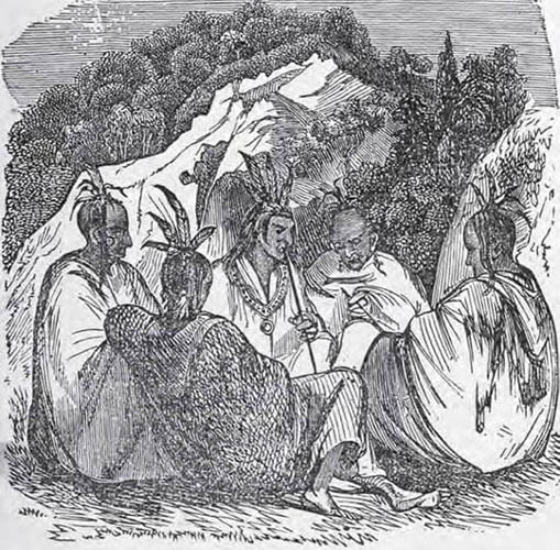
THE HISTORIANS OF KING PHILIP’S WAR often referred to three native camps located in Nipmuc country that were each used extensively throughout the war as places of shelter and defense. These sites, called Wachusett, Menameset, and Quabaug Old Fort, were strategically located between Narragansett and Wampanoag territory to the south, and the Connecticut River Valley Indians to the west. As such, they were centers of command that played host to an extraordinary mix of Native American peoples throughout King Philip’s War.
The first and most vaguely defined site was described by William Hubbard when he reported that the Narragansett, after their defeat at the Great Swamp Fight, marched north into Nipmuc country “toward Watchuset Hills meeting with all the Indians that had harbored all winter in those woods about Nashaway.”1 This same camp at “Watchuset Hills” was nearly attacked by Major Thomas Savage in March 1676, but the assault was called off when Savage marched to the Connecticut River to counter threats of an attack there.2 Mary Rowlandson was held captive at or near this same camp in April 1676; local historians place this site “on the western side of Wachusett, probably Princeton.”3 Despite these several references, the precise site of the Nipmuc’s “Wachuset Hills” camp is today unknown, though hikers and skiers undoubtedly trace the same paths that Philip and his armies walked in 1675 and 1676.
Menameset (sometimes written as Wenimisset) was perhaps the most important Native American military site of the war, and the site to which the Nipmuc fled immediately after the outbreak of hostilities in 1675. Menameset comprised three villages, described in detail by J. H. Temple in his History of Brookfield, Massachusetts. All three villages were seated on the eastern bank of the Ware River, in the northern section of New Braintree and the southern section of Barre.
The most southern (or “lower”) site of Menameset is marked by a small, inscribed stone situated on the north side of Hardwick Road just east of Wenimisset Brook. Behind the marker is a flat plain of perhaps five acres, bordered by the brook on one side. Historians George Ellis and John Morris believed that the encampment was about twenty rods from the Ware River,4 but modern historians are less convinced that the correct site has been discovered.5
Menameset’s “middle village” (heading upstream), thought to be another campsite that King Philip visited in 1675,6 is located north of Hardwick Road about a mile northeast of the first site. It can be found by walking north through North Cemetery at the “bend” in Hardwick Road and continuing through a small pine grove behind the cemetery. There one finds a perfectly flat plain of about forty acres stretching back to the Ware River, large and ideally suited for a camp, where numerous native artifacts have been found.
The northernmost camp (“upper village”) of Menameset is today a sand pit, located in the town of Barre just west of Airport Road, about seven-tenths of a mile from the New Braintree border. There, the Ware River forms a double oxbow, and it was in the lower bend of about nine acres that the camp probably sat.7 Many historians think it was here that Mary Rowlandson was held captive from February 12 to February 28, her third remove,8 and that this would be where she met Robert Pepper, who had been captured at Beers’ Ambush. Any evidence of Native American activity has been generally destroyed by the work of backhoes.
Temple also discussed in detail the sites of several other important Nipmuc villages, including their stronghold known as Quabaug Old Fort. Also called Ashquoach, this village has traditionally been located on Indian Hill, north of Sherman’s Pond (“Great Pond”) in Brimfield, Massachusetts, a short distance from the Warren town line.9 Levi Badger Chase, in his description of the Bay Path, noted the importance of Ashquoach’s location:
Four paths are mentioned as diverging from this point. The western path from Quabaug “Old Fort” passed north of Steerage Rock to the bend in Quabaug River; parting there, one branch kept south of the river, to Springfield, the other crossed the river into Palmer and on to the Great Falls of the Connecticut, now Holyoke City. Another path ran to the falls of Ware River; and still another to the Indian village of Wickabaug, now West Brookfield.10
Temple noted that Ashquoach was distinguished for its great cornfields and strong defenses, situated as it was at the highest point of the hill with an open view in all directions.11 It is thought that King Philip stopped here on August 5, 1675, on his flight from the Nipsachuck Swamp Fight, but finding the fort deserted, marched to Menameset where Nipmuc warriors were preparing for war.12 Today, the traditional site of Ashquoach can be found on the southeastern knoll of Indian Hill, on a flat spot beside the steep eastern slope, north of the split between Marsh Hill Road and Brookfield Road. The site is on private land and partially fenced.
More recently, in Wheeler’s Surprise: The Lost Battlefield of King Philip’s War, author Jeffrey Fiske has reexamined historical records and concluded that Ashquoach was most likely located “on a hill northwest of Quaboag Pond” in present-day Brookfield. Fiske believes the confusion has come about from use of the term “Connecticut Path” to describe not one but three ancient paths in Massachusetts.13
Wekabaug, not central to the war but the single largest Nipmuc camp in the area, was built on a bluff at the southerly end of Wekabaug (Wickaboag) Pond, adjacent to the pond,14 in present-day West Brookfield. This camp was visited by Massasoit in 1657 and apparently pledged allegiance to him at the time. Related sites include a camp located about three-quarters of a mile southeast and just across the river, a burial spot on a bluff at the northeasterly end of Wickaboag Pond, and two camps on Quaboag Pond in Brookfield. One of these latter camps was located at the fork of the Seven Mile Brook and Five Mile Brook, formerly a steep hill leveled during construction on the East Brookfield railroad station and freight yard.15
Massachusetts Bay had been involved in King Philip’s War from its outset, sending troops to assist Plymouth Colony at Swansea and to meet with the Narragansett in Rhode Island. On July 14, 1675, however, the war took on new meaning for officials in Boston when violence spread into Massachusetts Bay Colony itself. A Nipmuc band under Matoonas killed five or six residents of Mendon at work in the fields. The Nipmuc did not press their attack, fleeing instead into the surrounding woods. Hubbard noted that the settlement, “lying so in the Heart of the Enemies county, began to be discouraged,” and shortly after was abandoned.16
That winter the Nipmuc returned and burned the deserted settlement to the ground. The Reverend Increase Mather, in a rare attempt at humor, spoke to the spiritual health of the colony when he wrote that in “Mendam, had we mended our ways as we should have done, this misery might have been prevented.”17 Very little is known about the actual assault, nor have all the names of the victims been identified. One frustrated Mendon historian complained that the town records do not furnish “a single item of intelligence”18 concerning King Philip’s War. Based on land records, antiquarians have suggested an approximate location of the attack, and a marker at Providence Road and Hartford Avenue that designates the site reads:
NEAR THIS SPOT
THE WIFE AND SON OF
MATTHIAS PUFFER
THE SON OF JOHN ROCKWOOD
AND OTHER INHABITANTS OF
MENDON
WERE KILLED BY NIMUCK INDIANS
14 JULY 1675
THE BEGINNING OF KING PHILIP’S WAR
IN THE COLONY OF MASSACHUSETTS
In addition to this marker, the state of Massachusetts has designated the site of Mendon’s First Meetinghouse on Route 16 at Main Street. This structure was built in 1668 and lost in the general destruction of 1676.
In 1967, the town celebrated its three hundredth anniversary by issuing a commemorative coin, the reverse side of which depicted the massacre.
On August 2, 1675, one of the war’s best-known and most devastating ambushes, Wheeler’s Surprise, took place within the bounds of present-day New Braintree. The ambush occurred just as Philip was making his escape from English soldiers in the Nipsachuck Swamp and heading north to join his Nipmuc allies.
Captain Edward Hutchinson had been assigned the unenviable task of negotiating a treaty with the Nipmuc, in part because “he had a very considerable farm thereabouts, and had occasion to employ several of those sachems there, in tilling and plowing his ground, and thereby he was known by face to many of them.”19 Such a treaty, more threat than negotiation, was designed to keep the Nipmuc from joining Philip. In retrospect, the mission was doomed to failure: Mendon, Massachusetts, had already been destroyed by Nipmuc warriors, and Philip had just slipped past the English at Pocasset and was on the move. At the time, however, colonial officials still held that Wampanoag aggression could be contained in southern New England.
Hutchinson was experienced in this type of highly charged negotiation, having met with Narragansett leaders in June and July 1675 to force their signatures on a treaty of neutrality. He was accompanied in this new effort by three friendly Indians; three men from nearby Brookfield, including Sergeant John Ayres; Ephraim Curtis, an able and courageous scout who built the first home at Quinsigamond, or present-day Worcester; and Captain Thomas Wheeler, whose mounted force consisted of twenty men.20 Hutchinson, Wheeler and his troops had marched from Cambridge to Sudbury on July 28, 1675, and then west into Nipmuc territory. Most of the soldiers under Wheeler were from Billerica, Chelmsford, and Concord, and did not know the area into which they were riding.
When Wheeler and the party arrived at Brookfield (called Quaboag Plantation, now the Foster Hill section of West Brookfield) on Sunday, August 1, Curtis and three others were sent to arrange a meeting with the Nipmuc. Curtis discovered the Nipmuc at a camp about ten miles from Brookfield and drew from them a promise to meet with Hutchinson the following morning at 8 AM. The designated rendezvous spot was “upon a plain within three miles of Brookfield,”21 often thought to be the small plain at the intersection of Shea and Madden Roads in West Brookfield.22 When Hutchinson’s party arrived at the appointed hour there were no Nipmuc to be found.
This location can be visited today, though there is little left resembling what Hutchinson and Wheeler might have seen. The site was examined as long ago as 1871 by historian Ebenezer Peirce, who wrote:
The scene was almost entirely changed from that of one hundred and ninety-six years before. True, the pond [Wickaboag Pond] occupied the site it did then, and the soil of the plain was yet there, but all else, how completely changed! I suppose that I passed over the identical ground on which it was proposed to meet and make a new treaty with the Indians.23
Upon reaching this location, the men debated among themselves whether to proceed with the mission or return to Brookfield. Captain Wheeler, who would survive the ensuing ambush and write a firsthand account not many months later, noted:
But the three men who belonged to Brookfield were so strongly persuaded of their freedom from any ill intentions toward us . . . that the said Captain Hutchinson, who was principally intrusted with the matter of Treaty with them, was thereby encouraged to proceed and march forward towards a Swamp where the Indians then were.24 When we came near the said Swamp, the way was so very bad that we could march only in a single file, there being a very rocky hill on the right hand, and a thick swamp on the left, in which were many of those cruel blood-thirsty heathen, who there way laid us, waiting an opportunity to cut us off; there being also much brush on the side of the said hill, where they lay in ambush to surprise us. When we had marched there about sixty or seventy rods, the said perfidious Indians sent out their shot upon us as a shower of hail, they being, (as was supposed,) about two hundred men or more.25
Eight English were killed immediately or wounded and left for dead, including all three men from Brookfield who had encouraged Hutchinson to push on. Five others were wounded but escaped, including Wheeler, Wheeler’s son (who saved his father’s life), and Hutchinson. Hutchinson died from his wounds soon after and was buried in Marlboro, Massachusetts.26
When the party attempted to retreat, the Indians prevented them from going back the way they came, forcing them instead to retreat by clambering up a “steep and rocky hill.”27 Wheeler added that “we returned to the town as fast as the badness of the way and the weakness of our wounded men would permit, we being then ten miles from it,”28 and also noted that “none of us knew the way, those of the town being slain; and we avoiding any thick woods, and riding in open places to prevent the danger by the Indians.”29
There are the essential facts of the ambush and retreat as they have been handed down through Wheeler’s firsthand account. Ever since, historians and antiquarians have speculated as to the precise location of the attack. In a footnote to the 1843 publication of an oration he delivered in 1828, Joseph Foot suggested that the precise site would never be determined:
The spot where Captain Hutchinson and his company were attacked cannot be ascertained. There are two places, which tolerably answer the description given by historians. The one is near the line of Brookfield and New Braintree. The other is nearly two miles north of this line. Without records and with contradictory traditions it is probably impossible to determine with certainty at which place the onset was made.30
Foot’s conclusion notwithstanding, speculation on the site of Wheeler’s Surprise became something of a heated debate in the late nineteenth century, with so many papers being delivered on the subject that one historian felt a complete bibliography was needed.31 However, all the debate focused around two particular locations—not necessarily consistent with Foot’s theory—both of which can still be investigated by historical sleuths interested in determining for themselves the true location of Wheeler’s Surprise.
In 1884, the Reverend Lucius R. Paige published a paper in the New England Historic Genealogical Register entitled “Wickaboag? Or Winnimisset? Which Was the Place of Capt. Wheeler’s Defeat in 1675?” In it, Paige made the case for Wheeler’s Surprise having occurred in Winimisset Meadows, somewhere along a mile stretch east of the Winimisset Brook, just west of the steep hill rising toward Brookfield Road. Paige knew this area well “because his grandmother in her girlhood resided on the border of the Winimisset (or Meminimisset) Valley . . . and because he saw it so often when he was a boy.”32 Today that site is along Slein Road, perhaps near an A-frame house located about one-half mile north of the intersection of Wine Road. (This site is referred to by Paige as the Fay Farm or Brookside Farm.) A bird’s-eye view of the area can be seen from a stone marker commemorating Wheeler’s Surprise, located on West Road, three-tenths of a mile north of Unitas Road. The marker reads:
SOMEWHERE WITHIN 1/2 MILE
ALONG THE BASE OF THIS HILL
CAPT. EDWARD HUTCHINSON AND
HIS COMPANY WERE ATTACKED
BY INDIANS LYING IN AMBUSH
AUG. 2 1675 AND HE AND MORE
THAN ONE HALF HIS MEN SLAIN
OR WOUNDED.
The state of Massachusetts has indicated this same general area on a marker located on Route 67 (Barre Plains Road) near Thompson Road.
Paige’s argument relied on an interpretation of Wheeler’s report that his party was ambushed in the same swamp in which Curtis had met with the Nipmuc the prior day, “about ten miles north-west from us,”33 according to Wheeler, or about “eight miles from Quabouge,”34 according to Curtis. Winimisset (or Wenimisset) Meadows is eight to ten miles from Foster Hill, depending upon the route taken. This location was bolstered by William Hubbard’s history, in which he reported that Wheeler’s party was ambushed “four or five miles”35 from the appointed rendezvous place; Winimisset Meadows is four or five miles from the plain at the head of Wickaboag Pond. In addition, local tradition had long indicated Winimisset Meadows as the site of Wheeler’s Surprise.
In 1893, nine years after Paige made his case for Winimisset Meadows, a map entitled “A New Plan of Several Towns in the County of Worcester,” prepared by General Rufus Putnam and dated March 30, 1785, was discovered at the Massachusetts Historical Society. The map, which measured twenty by twenty-eight inches and covered an area of about 450 square miles, included the towns of Rutland, Oakham, Hardwick, New Braintree, Brookfield, and Warren, as well as parts of about thirteen other nearby towns. The map had been given to the historical society on April 9, 1791, and was accidentally bound into a folio volume entitled Atlas Ameriquain Septentrional and, hence, lost for over a century.36 Designated on this map in the general vicinity of the site indicated by Paige was the note: “Hutchinson & Troop Ambushed between Swamp & Hill.”37 This map, prepared by an esteemed Revolutionary War soldier, a noted civil and military engineer, and a man who spent part of his childhood in New Braintree, seemed to prove Paige’s conclusion. Paige “expressed his satisfaction in the discovery of the Putnam map, inasmuch as it so fully coincided with his own opinion . . . [and] if not full proof of the correctness of his own theory, [it was] at least a very respectable precedent.”38
Several important issues remained, however, and these were tackled by J. H. Temple in his History of North Brookfield, Massachusetts, published in 1887 after Paige’s publication but before the discovery of Putnam’s map. Temple offered the opinion that Wheeler’s Surprise occurred in a more southerly location, only a few miles north of Wickaboag Pond, between Mill Brook and Whortleberry Hill. As part of his research, Temple “traversed the valley from Barre Plains to Wekabaug pond”39 but could find no location in Winimisset Meadows matching Wheeler’s description of a “narrow defile.” Further, Temple did not believe that the Nipmuc would endanger their own camp by setting an ambush so close to it.
Temple then turned to the testimony of two Indian guides in Wheeler’s party. One, James Quannapohit, said that Menemesseg (another name for Winimisset; neither term was ever used by Wheeler in his report) was “about eight miles north from where Capt. Hutchinson and Capt. Wheeler was wounded and several men with them slain.”40 George Memicho, who was taken captive in the ambush, said that he was taken to a camp “six miles from the swamp where they killed our men.”41 Temple believed that both descriptions pointed to a location south of Winimisset Meadows and not far from the head of Wickaboag Pond. In fact, Temple noted, if William Hubbard’s estimate of Wheeler and his party riding four to five miles were applied to their starting location at Foster Hill, this would also point to his more southerly location.42
What sealed this new location (sometimes referred to as the Pepper farm) for Temple, however, was his identification of a spot in “very complete agreement of existing conditions with all the details given in Capt. Wheeler’s Narrative.”43 That spot, which is nearly unchanged today from the engraving shown by Temple in his History of North Brookfield, is located on private land off Barr Bridge Road along Mill Brook. A walk along this hillside, which is no longer particularly rocky, gives one a good sense for how an ambush might develop, how difficult the defile between the hillside and swamp might have been to travel, and how impossible it would have been to escape on horseback in any direction but up and over the hill.
To the modern historian, both sites are interesting but neither conclusive. Paige’s location carries the weight of tradition, made an even less reliable source than usual in New Braintree because nobody lived there at the time of the ambush. There is, however, a tantalizing note from Captain Samuel Moseley written to Governor Leverett from Lancaster on August 16, 1675, in which Moseley and about sixty men
marched I(n) company with Capt. Beers & Capt. Lathrop to the Swamp where they left me & took their march to Springfield and as soon as they ware gone I took my march Into the woods about 8 miles beyond the Swamp where Capt. Hutchinson and the rest were that were wounded & killed.44
If Moseley knew the location of the ambush, then perhaps it was common knowledge to many soldiers stationed in the area. This would bolster tradition as a historical source despite New Braintree’s lack of settlement in 1675. Paige also has General Putnam’s map supporting him, but Putnam prepared the map more than a century after the event and himself relied on local tradition. Perhaps most damaging to Paige is that no location can be found which resembles even vaguely the one described by Wheeler. Modern historians believe that the swamp along Winimisset Brook was closer to the hillside in former times, but whether it ever matched Wheeler’s description is unknown. In 1899, D. H. Chamberlain investigated Winimisset Meadows, taking six trips on foot, horseback, or wagon and making ten separate visits to particular points. He was, even a century ago, unable to find a location matching Wheeler’s description.
Temple has in his favor the discovery of a location that very closely matches Wheeler’s report. In addition, local tradition also sides with Temple; older citizens of New Braintree referred to the Pepper farm location as “Death Valley.” The weaknesses in Temple’s arguments are Hubbard’s contention that Wheeler’s party rode four to five miles from their first rendezvous point, near the head of Wickaboag Pond, which would place them eight to nine miles from Foster Hill.45 Also, Wheeler says that his party retreated ten miles from the scene of the ambush back to Foster; even riding a circuitous route through North Brookfield to avoid ambush, it is difficult to find ten miles between Temple’s ravine and Foster Hill.
George Bodge, writing in 1906, found merit in both arguments and noted that “both Paige and Temple are eminent authorities in antiquarian research; both reason from the same evidences in general . . . I am free to say that reading the arguments of both again and again, I am unable to decide which is the most probable site of the encounter.”46
Some historians, including Chamberlain, have virtually dismissed the use of mileage, arguing that the distances given were estimates made under extreme duress. Others, like Louis Roy, have guessed at the best path between Brookfield and the Nipmuc camps at Winimisset and, by examining a topographic map, determined the location of the ambush. Roy believed that Wheeler’s party traveled the Bay Path and that the ambush occurred on present-day Padre Road, about two-tenths of a mile south of the split from West Road.47
Of course, the real surprise in Wheeler’s Surprise for modern historians may be that we have completely missed the route taken by Wheeler’s party. It is possible that, having left the first rendezvous point, Wheeler and his men rode to the east of Whortlebury Hill, along the high land of West Brookfield Road. They may have taken this route specifically to avoid ambush along the more heavily traveled Bay Path, or because the distance was shorter, or because the terrain was better for a large group on horseback.48
Local historian Jeffrey Fiske, in his thoughtful and thorough Wheeler’s Surprise: The Lost Battlefield of King Philip’s War, has taken a careful look at the information and misinformation surrounding 1) the destination of Wheeler and Hutchinson; 2) their route of march; and 3) how their distance was calculated and reported. Fiske concludes that, “while the ambush sites suggested by Josiah Temple and Dr. Louis Roy are incorrect,” and the general area suggested by Lucius Paige is a reasonable estimate for the location of Wheeler’s Surprise, “I have not been able to absolutely identify the ambush site.”49
Two rumors had surfaced in the distant past concerning Wheeler’s Surprise. One concerned Wheeler’s sword, which was said to have been discovered in Winimisset Meadows. The other had to do with a pile of horse bones uncovered in the same location. Both are unsubstantiated and add only color to our knowledge of Wheeler’s Surprise, which remains nearly as much a mystery today as it was a century ago.
When Captain Thomas Wheeler and his remaining men fled the ambush at New Braintree, they sought safety at the English settlement of Quabaug, now the Foster Hill area of West Brookfield. Quabaug had been settled in 1660 by men from Ipswich, Massachusetts. At the time of King Philip’s War, it was an isolated farming settlement of barely twenty homes.50 Its closest neighbor was Springfield, a day’s journey to the west. Douglas Leach suggests that “indeed, scarcely a town in all of Massachusetts could claim the dubious distinction of being more isolated than Brookfield.”51

The Nipmuc used this flaming cart, filled with birch bark, straw, and powder, in an unsuccessful attempt to dislodge the English from the Ayres garrison. (Courtesy of the Haffenreffer Museum of Anthropology, Brown University)
The surprise return of Wheeler and his exhausted troopers from their disastrous meeting with the Nipmuc alerted the settlers at Quabaug to danger. The frightened inhabitants abandoned their homes and fled to the house of Sergeant John Ayres. (Ayres had accompanied Wheeler and Hutchinson on their mission to parley with the Nipmuc, and for his efforts was lying dead at the New Braintree ambush site.) In all, eighty people gathered in this one home and prepared to defend themselves against the Nipmuc assault. Henry Young and Ephraim Curtis immediately set out on horseback for Marlboro but soon met hostile Nipmuc. They fled back to the garrison and shortly thereafter the assault began.
The August 1675 siege of Brookfield would last almost three days and become one of the most dramatic military engagements of the war. Upon their arrival at Quabaug, the Nipmuc warriors under Muttawmp immediately set fire to all of the structures except the fortified garrison. For forty-eight hours they surrounded the building and, in William Hubbard’s account,
assaulted the poor handful of helpless people, both night and day pouring in shot upon them incessantly with guns and also thrusting poles with fire-brands, and rags dipped in brimstone tied to the ends of them to fire the house; at last they used this devilish stratagem to fill a cart with hemp, flax and other combustible matter, and so thrust it back with poles together sliced a great length, after they had kindled it; But as soon as it had begun to take fire, a storm of rain unexpectedly falling, put out the fire, or else all the poor people, about seventy souls, would either have been consumed by merciless flames, or else have fallen into the hands of their cruel enemies, like wolves continually yelling and gaping for their prey.52
The English in the Ayres garrison responded as best they could, but the scene must have been chaotic and terrifying. Henry Young ventured too close to a window and was mortally wounded. A son of Sergeant William Pritchard attempted to secure desperately needed supplies from a nearby building, perhaps his own residence on the first lot east of Ayres’ garrison, but was captured and killed. For intimidation, the Nipmuc mounted Pritchard’s head on a pole. (Sergeant Pritchard himself had been killed at Wheeler’s Surprise). Thomas Wilson, one of the earliest English settlers at Quabaug, was shot through the jaw while attempting to secure water from a well not far from the garrison. Amidst this death and destruction there was also life, however, as two sets of twins were reported born during the siege.53
The English were surrounded but not completely helpless. They returned fire and continually thwarted Nipmuc attempts to set the garrison aflame. Reports of eighty Nipmuc killed were undoubtedly inflated,54 but Muttawmp and his warriors did not go without loss. Indeed, Ephraim Curtis was able to find enough weakness in the siege line to crawl past the Nipmuc on August 3 and make his way by foot the thirty miles to Marlboro.
Major Simon Willard and his forty-eight troopers55 were conducting operations west of Lancaster and arrived first at Quabaug. Willard, who at seventy years of age was the chief military officer of Middlesex County, had heard reports of the Nipmuc attack from people traveling along the Bay Path. He and his men rode the thirty-five or forty miles to Brookfield and arrived after nightfall on August 3,56 where they charged past the Nipmuc sentries, whose warning shots went unnoticed. Increase Mather wrote:
the Indians were so busy and made such a noise about the house that they heard not the report of those guns; which if they had heard, in all probability not only the people then living at Quaboag, but those also that came to succor them had been cut off.57
Willard’s party58 rode almost to the door of the Ayres garrison before they were spotted. With their arrival, the Nipmuc fired the remaining buildings and broke off the siege. Soon after, colonial reinforcements arrived, swelling the ranks of men under Willard to 350 English plus the Mohegan that had pursued Philip so successfully at Nipsachuck. Willard would stay for several weeks to direct military activity in the area, but the residents had little reason and little hope of real security, so the settlement at Quabaug was abandoned.
The landmarks related to the original Quabaug Plantation settlement are well marked along the north side of Foster Hill Road in present-day West Brookfield. Much of the site today is a large, open field. Traveling west, the first marker (set in a stone wall near a more modern home) designates the Ayres garrison, followed by a more elaborate memorial to John Ayres and a small stone marking the well at which Major Wilson was shot. Further west, still on the north side of Foster Hill Road, is a stone indicating the location of the first meetinghouse, burned in 1675, and a second built in 1717. The plantation’s burial ground, dated 1660–1780, is designated to the northeast of the meetinghouse location.

Foster Hill Road in West Brookfield, Massachusetts, is the site of Quabaug Plantation, attacked and destroyed by the Nipmuc in August 1675. The large memorial on the right designates the site of the Ayres garrison. (Eric Schultz)
The precise site of the Ayres garrison was apparently in some dispute in the early nineteenth century. In 1843 Joseph Foot noted:
There has been of late years no small disagreement respecting the place, where the fortified house stood. Some have attempted to maintain that it was northeast of Foster’s Hill. But as no satisfactory evidence in support of this opinion has been found, it is to be regarded as unworthy of credence. There are several weighty reasons for believing, that it stood on a hill. 1. The principal English settlement was there. 2. The meeting-house which was burned by the Indians was there. 3. In the account of the attack on the fortification a well in the yard is mentioned, and a well has been discovered near the north west corner of Mr. Marsh’s door yard, of which the oldest inhabitants can give no account except as they have been told, it belongs to the fortified house. 4. At a distance of a few feet north of the well the ground when cultivated as a garden was unproductive. As the soil appeared to be good, it was difficult to see any reason for the barrenness. On examination however it was found that a building had stood on the place. Several loads of stone, which had formed a cellar and chimney were removed, amongst which various instruments of iron and steel were found. 5. There is a hill directly west of this place, which corresponds sufficiently well with the descriptions of that, down which the Indians rolled the cart of kindled combustibles. There is then good reason to conclude that it stood between Mr. Marsh’s house and barn.59

This beautiful, detailed engraving shows the assault on the Ayres garrison, which lasted for three days and resulted in the abandonment of Brookfield. (Courtesy of the Haffenreffer Museum of Anthropology, Brown University)
A state marker on Route 9 at the boundary of Brookfield and West Brookfield encapsulates the whole grim story of Brookfield’s early years in a few short lines:
BROOKFIELD
SETTLED IN 1660 BY MEN FROM
IPSWICH ON INDIAN LANDS CALLED
QUABAUG. ATTACKED BY INDIANS
IN 1675. ONE GARRISON HOUSE
DEFENDED TO THE LAST. REOCCUPIED
TWELVE YEARS LATER.
On August 24, 1675, just a few weeks after the siege of Brookfield, the English held a council of war at Hatfield to address the growing native presence at the Norwottock village, located on a bluff along the western bank of the Connecticut River above Northampton. A force of one hundred men commanded by Captains Thomas Lathrop and Richard Beers was ordered to surprise and disarm these natives, none of whom had committed any hostilities against the English. Divining English intent, the Norwottock fled the camp just before Lathrop and Beers arrived on the morning of August 25. Finding the native fires still smoldering, the English sent a portion of their troops to defend Hatfield while the remainder set off in pursuit of the natives.
A mile south of present-day South Deerfield, near the rise known as Wequomps (present-day Sugarloaf Mountain), colonial soldiers overtook the Norwottock, who dashed into present-day Hopewell Swamp. There they set an ambush for the English troops. Mather reported that
on a sudden the Indians let fly about forty guns at them, and was soon answered by a volley from our men; about forty ran down into the swamp after them, poured in shot upon them, made them throw down much of their baggage, and after a while our men after the Indian manner got behind trees, and watched their opportunities to make shots at them.60

While the exact location of the battle is unknown, Hopewell Swamp in South Deerfield, Massachusetts, shown circa 1906, was the location of the so-called Battle of South Deerfield, a three-hour skirmish that Puritan commentators fashioned as a great victory for the English army. In reality, it turned the peaceful Norwottock against the colonists and cost the English nine soldiers. (From King Philip’s War, George W. Ellis and John E. Morris, 1906)
The fight lasted three hours. The English lost nine men and the natives were said to have lost twenty-six,61 probably an exaggeration designed to turn the first military engagement in the Connecticut River Valley into a desperately needed English victory. The real result of this Puritan-styled “Battle of South Deerfield” was to turn the neutral Norwottock into deadly enemies.Writing in 1872, J. H. Temple discovered a location that met all the particulars of the Battle of South Deerfield. The spot was located about a quarter mile south of Sugarloaf Mountain where the old Deerfield trail skirted the edge of Hopewell Swamp. Here, Temple wrote, was a ravine that allowed the natives good cover, the ability to fire up both sides of the bluff, and an excellent retreat route. Temple even made an engraving of the location.
Today local tradition places the battle in Whately, Massachusetts, though there is no agreement as to the precise location. The swamp south of Sugarloaf Mountain is quite large and has been altered considerably over the years by drainage, industry, and the construction of homes. There are many spots that would seem to match Temple’s description, and it seems unlikely that we will ever have more than a general sense as to where the battle took place.62
Squakeag, now Northfield, was located a few miles north of Deerfield near the present-day New Hampshire border. Barely three years old, Northfield, as described by Ellis and Morris, consisted of “some seventeen thatched cabins, a palisade of rough logs eight foot high set upright in the ground and pierced with loopholes, and a log fort and church.”63 The most far-flung of the Connecticut Valley settlements, Northfield was generally isolated from the violence that had occurred in Brookfield, Whately, and New Braintree, and in the Plymouth Colony settlements farther south.
On September 1, 1675, sixty natives attacked and burned buildings and barns in Deerfield. When the inhabitants of Northfield awoke on Thursday, September 2, they were still unaware of this attack. Heading off in pursuit of their daily activities, the Northfield settlers were suddenly assaulted by a mixed band of Pocumtuck and Nashaway led by Monoco. Eight English were killed. The settlers rushed from their houses and fields to the stockade, watching as their homes went up in flames.
Massachusetts Bay authorities decided to evacuate Northfield immediately. On Friday, September 3, thirty-six mounted men and one ox team under the command of Captain Richard Beers of Watertown, Massachusetts, began the thirty-mile march from Hadley. Unable to reach Northfield before sundown, Beers and his men camped three miles south of the town, perhaps near Four-Mile Brook.64
On Saturday morning, September 4, Beers left his horses under guard at the camp and began the short march to Northfield. His decision to approach the town by foot may have indicated that he expected to meet resistance, but Beers did not take the usual precaution of sending scouts and flankers to protect the main force. In addition, Beers made no attempt to alter his route from the usual approach to Northfield, along the high plain.
Marching north, the English troops kept to the high way65 until they sighted Sawmill Brook, which flowed through a ravine still thick with summer growth. (This main path to the settlement was probably to the east of present-day Route 63, on slightly higher ground.)66 They followed along the left bank of the brook and then
attempted to cross it where a depression in the plain made a passable fordway, in order to reach the hard land south and west of dry swamp, and so come into the village near where is now the south road to Warwick.67 This was the common route of travel at the time; and the Indians knew that, as matter of course, he would take it, and made their plans accordingly. Concealed in front, and behind the steep bank below the crossing-place, on his right, they fired upon the carelessly advancing column just as the head was passing the brook, when it would have been exposed for its entire length.68
The location of the ambush is marked on the east side of Route 63, just north of the Community Bible Church. The marker reads:
INDIAN COUNCIL FIRES
TWO HUNDRED AND FIFTY YARDS
EASTWARD ARE THE SITES OF THREE
LARGE INDIAN COUNCIL FIRES. THE
BEERS MASSACRE OF SEPTEMBER
4, 1676, TOOK PLACE IN A GORGE
ONE-QUARTER MILE TO THE
NORTHEAST
Sawmill Brook, shown on modern topographic maps as Roaring Brook, can be reached by a dirt road north of the marker. (The dirt road is on private property and sometimes blocked.) The precise location of Beers’ crossing is conjecture only, though one or two places seem logical. The spot where the dirt road first skirts the brook also affords an excellent view of Beers Mountain and Beers Hill, the direction in which the captain retreated.
The English were thrown into confusion by the attack but, as J. H. Temple and George Sheldon decribe the encounter, were able to fight their way out of the ravine and make a stand “towards the south end of the plain, where is a slight rise of land.”69 This plain, now called Beers Plain, is designated by a marker just a short distance north of the “Indian Council Fires” sign.70 Beers Plain runs north from this spot and west toward the Connecticut River. Temple and Sheldon believe it to have once been the site of a Native American village, “as attested by the remains of their granaries, and their large burial places.”71
As the English fell, Beers and a few survivors were able to retreat to a small ravine about three-quarters of a mile away on the southern spur of present-day Beers Mountain, sometimes called Beers Hill. Here Captain Beers was killed. Two days later his body was buried.
A marker on the east side of Route 63 near the Community Bible Church designates the general area of Beers’ last stand. The site of Beers’ grave can be found at the base of the main building of the Linden Hill School near the intersection of South Mountain Road and Lyman Hill Road. A modern stone marker indicates the burial spot. Temple and Sheldon, writing in 1875, provide a glimpse as to how the site was altered before the present stone marker was set.
The tradition which marks this as the spot where Capt. Beers was killed and buried, is of undoubted authenticity. The old men in each generation have told the same story, and identified the place. And the existence here from time immemorial of two stones—like head and foot stones—set at the proper distance apart, certainly marks the place of a grave; and the care to erect stones indicates the grave of more than a common solider. The new house of Capt. Samuel Merriman, built about 50 years ago, was set directly across the ravine, which was made to answer for a cellar by filling in the space front and rear. Capt. Ira Coy informs the writer that, before any thing was disturbed, he and Capt. M. dug into the grave. They found the well defined sides and bottom, where the spade had left the clay solid; and at the depth of about twenty inches (the shallowness indicating haste) was a layer of dark colored mold, some of it in small lumps, like decayed bones. The grave was then filled up, a large flat stone laid over it, and the hollow graded up.72

This nineteenth-century engraving may represent the ambush of Captain Beers and his men in Northfield. The movement of goods from abandoned towns not only fed the English army, but also deprived the natives of the spoils of war. (Courtesy of the Haffenreffer Museum of Anthropology, Brown University)
The Linden Hill School building which now sits near the site is more recent than the one described by Temple. Beers’ grave marker has been moved from its original site, farther along the lawn to a position closer to the street.73
Temple and Sheldon also note that iron from the teamsters’ cart used by Beers was discovered in the early nineteenth century and worked up by a local blacksmith.74 In addition, local histories relate that as late as 1824, “at a sandy knoll on the west side of the road, near the place where the attack commenced, the bones of the slain are still to be seen, in some instances, bleaching in the sun. Until lately the mail route from Montague to Northfield passed over this ground.”75
The ambush was devastating to the English, who lost twenty-one men. Thirteen men, including the guard left with the horses, returned to Hadley that evening. Two more straggled in the following day, including one who had escaped from capture and reported, however accurately, the deaths of twenty-five natives during the attack.76 One man arrived confused and nearly starved six days later; he had escaped the ambush by hiding in a gully and covering himself with leaves. This gully is known as Old Soldiers Hole, a deep ravine leading from Beers Plain to the Connecticut River, one-quarter of a mile south of the lower point of Three-little Meadows.77 It is today split by Route 63 and the railroad embankment, almost directly west of Beers Hill.
On September 6, Major Robert Treat and about one hundred men rescued the anxious settlers of Northfield, still stranded in their stockade. Along the way Treat and his men found the decapitated heads of some of those slain stuck on poles, and one, wrote Hubbard, was found “with a chain hooked into his under jaw, and so hung up on the bow of a tree.”78 Such sights completely demoralized the English, who buried the dead, evacuated the town, and left it to be destroyed.
Several other sites around Northfield are associated with King Philip’s War. On Monday, March 6, 1676, Mary Rowlandson of Lancaster stayed with her Indian captors at a camp by the side of the Great Swamp described by Temple and Sheldon near “where the highway to Wendell crosses Keeup’s Brook, to the east of Crag Mountain.”79 The historians add that Philip’s Hill, “a projection of the plain which comes near to the river bank,”80 is located on the west side of the Connecticut River north of Bennett’s Meadow. This was said to be a fortified Indian site during the war and Philip’s camp for part of the winter of 1675–1676. “This hill was defended by a ditch and bank on the westerly side, and otherwise by its steep ascent; but being only about sixty feet high, it was a position of no great strength.”81 In 1897, twenty-five years after postulating the existence of Philip’s fort at this site, Sheldon reversed his position, writing, “What you see on Philip’s Hill is the work of honest John Tomkins, and not that of a fort which King Philip never built.” Tomkins, Sheldon continued, was a “hedger and a ditcher” who left a legacy of ditches around Northfield designed as the “the cheapest and most enduring fences” to hold livestock.82
On September 12, 1675, just a few days after the evacuation of Northfield, the settlement at Deerfield was assaulted for a second time by a small band of warriors who managed to burn two houses and steal several wagons full of food. Deerfield was a tempting target for the Indians because of its poor defenses and excellent fall harvest. Recognizing this, Massachusetts Bay leaders decided to evacuate Deerfield and sent troops under Captain Thomas Lathrop of Beverly, Massachusetts, to escort teamsters from Deerfield to Hadley. There, the foodstuffs could be distributed throughout the Connecticut River Valley towns during the winter months.
On September 18, Lathrop led seventy-nine men83 and a number of carts loaded with provisions on a slow march from Deerfield to Hadley. Several miles south of Deerfield near a shallow brook in present-day South Deerfield, the convoy’s lead stopped to rest and allow the teamsters in the rear time to catch up. Like Increase Mather, who describes a scene in which many of the soldiers were “so foolish and secure as to put their arms in the carts, and step aside to gather grapes, which proved dear and deadly grapes to them,”84 we can only wonder what Lathrop was thinking at the time, given the recent attacks on Deerfield and the fatal ambush of Captain Beers on a similar mission to Northfield two weeks before. Edward Everett suggested that nearby scouting activity by Captain Moseley and his troops, and the sense that one of the more difficult legs of the journey had been completed, led to carelessness:

This depiction of the massacre at Bloody Brook shows Captain Lathrop’s men marching from Deerfield and illustrates how the distance between the teamster carts made a concentrated defense against the Nipmuc ambush nearly impossible. (Courtesy of the Haffenreffer Museum of Anthropology, Brown University)
Captain Moseley, who had arrived on Connecticut River three days before, was at this time stationed with his company at Deerfield, and proposed, while Captain Lothrop was on the march downward, to range the woods in search of the enemy . . . It is not improbable that Captain Lothrop and his men, relying too much on Moseley’s cooperation, proceeded without due caution. Having passed with safety through a level and closely-wooded country, well calculated for a surprise, and deeming themselves in some degree sheltered by the nature of the ground they had reached, the tradition is, that on their arrival at the spot near which we are now assembled, their vigilance relaxed. The forest that lines the narrow road, on which they were marching, was hung with clusters of grapes; and, as the wagons dragged through the heavy soil, it is not unlikely that the teamsters, and possibly part of the company, may have dispersed to gather them.85
Not only did Deerfield suffer considerable destruction during King Philip’s War, but the village would fall victim again in 1704 to a lightning raid by Indians migrating along the Connecticut River Valley to Canada.
Lathrop’s lapse in judgment would prove fatal. Muttawmp and his “multitudes”86 set upon the English in a “sudden and frightful assault,”87 killing Lathrop almost immediately. More than forty soldiers and seventeen teamsters were killed.88 Captain Samuel Moseley and his troops were patrolling nearby and dashed to the rescue, only to be drawn into the fight with taunts of “Come on, Moseley, come on. You want Indians. Here are enough Indians for you.”89 All afternoon Moseley and his men fought, losing eleven90 and coming dangerously close to being completely surrounded and destroyed, until Major Robert Treat arrived around dusk with enough reinforcements to drive Muttawmp and his men from the field.
The brook at which Lathrop and his men paused, once called Muddy Brook, was said to have turned red with English blood and has ever since been known as Bloody Brook. Today, it crosses under Main Street in South Deerfield about one mile south from the intersection of Route 5; this is said to be precisely the spot at which Lathrop passed.91
Two memorials are maintained at the site. A white marble monument was erected in 1838 and stands just south of the brook at the bend in the road near Frontier High School. The cornerstone for the monument was laid in 1835 at an occasion that brought Edward Everett, General Epaphas Hoyt of Deerfield, and about six thousand people to the site. Everett delivered his keynote address under a walnut tree just east of the monument.
The second Bloody Brook memorial, and perhaps the oldest surviving monument to veterans in America, is found about one hundred yards south of the marble monument in the front yard of 286 North Main Street. This rectangular slab is set horizontally in the ground and marks the common grave of Lathrop and the men buried there by Treat and Moseley the day following the ambush.92 This monument was moved so many times by owners of the property that in 1835 a committee of investigation was formed93 to identify the precise location of the mass grave. Guided by “tradition and some aged people”94 the committee located the spot. A contemporary account reported that the bones of about thirty men were found “in a state of tolerable preservation, but fell to pieces on exposure to the air”;95 these were all that remained of the “sixty persons buried in one dreadful grave”96 described by Increase Mather. On the same day that the English mass grave was rediscovered, the committee also reported finding a grave with the remains of ninety-six Native Americans, about a half mile distant, to the southwest of the grave of Lathrop.97 Contemporaries assumed that these natives had been killed in the fight. Edward Everett supposed that the Indian warriors
The Bloody Brook Memorial was dedicated in 1838 by the governor of Massachusetts, Edward Everett, and stands today as one of the most visible reminders of King Philip’s War. (Eric Schultz)
The site of the Bloody Brook battle, captured in this early-twentieth-century photograph, shows the crossing at North Main Street in South Deerfield, Massachusetts, and the marble monument placed in 1838. Bloody Brook is one of the most famous and best-visited sites of King Philip’s War. (From King Philip’s War, George W. Ellis and John E. Morris, 1906)
fled across the brook, about two miles to the westward, closely pursued by the American force, and here the action was probably suspended by the night. A quantity of bones, lately found in that quarter, is very probably the remains of the Indians who fell there at the close of the action.98
We will never know if Everett was correct in his assumption, but we can be sure that Moseley and Treat would have been surprised to discover that, in Everett’s nineteenth-century terms, they had become the “American force” at Bloody Brook.
Springfield’s location on the Connecticut River and at the junction of two important colonial trails made it second only to Hartford in importance among the Connecticut River Valley towns. On the eve of King Philip’s War the settlement boasted a population of five hundred English settlers scattered about four distinct villages. These included the town center; a settlement opposite the center on the west bank of the Connecticut River; Longmeadow, located four miles south of the center; and Skepnuck, situated three miles northeast of the center.
About a mile south of the center, on a bluff along the east bank of the Connecticut River nearly opposite the Westfield River, sat a palisaded Agawam Indian village. The site is today referred to as Longhill, and the village itself, Fort Hill (which is designated by a marker at the intersection of Sumner Avenue and Longhill Street99). It was established as a native village about 1650 and was made famous as the staging grounds for an Agawam-led assault on Springfield during King Philip’s War.
Fort Hill’s boundaries have never been precisely determined, but a Springfield historian’s description of the site in 1886 noted the following:
A little plateau on a prominent spur of a hill, with abrupt declination shaped liked a sharply truncated cone, afforded natural advantages for a fort. There is a deep ravine on the south side, which was probably the fortified approach to the fort. Many stone arrow-heads and hatchets have been found in this ravine . . . It has been assumed by some that only a part of the plateau was included in the fort . . . [but] it is fair to conclude that the whole brow of this hill was surrounded by a stockade.100
In 1895 local historian Harry Andrew Wright excavated Fort Hill. He discovered (among hundreds of artifacts) “the site of ten rows of lodges and two large council houses,” as well as “a pattern of post molds uncovered along the western margin of the bluff,”101 confirming that the village had been palisaded. A short distance south of the site, Wright uncovered thirteen burial sites.
More recently, William R. Young and John P. Pretola of the science museum in Springfield have studied Fort Hill.102 The site has yielded artifacts (housed in collections at the Springfield Science Museum, the Skinner Museum at Mount Holyoke College, and the Peabody Museum at Harvard University) such as a German silver-plated spoon consistent with the mid-seventeenth-century occupation of Fort Hill; “Dutch fairy pipes” from Bristol, England; finished gunflints; three good examples of Native American ceramics; and even an oyster and quahog shell, indicating contact with coastal native groups.103 More puzzling to Young and Pretola is the relative lack of structural features at the site, making it impossible to reconstruct the configuration of Fort Hill, and leaving the possibility that more of the site is still unexplored.104
Among Springfield’s most influential residents was Major John Pynchon, son of Springfield’s founder and a successful merchant who played an important role in the establishment of several Connecticut River Valley towns. Despite his business success, Pynchon was no soldier and had asked Massachusetts Bay officials on two occasions to be relieved of his post as commander of all colonial troops in the valley. Pynchon was especially at odds with the council’s military strategy, which emphasized an offensive campaign where every soldier took to the field, often leaving Springfield and nearby towns undefended.
Pynchon watched with anguish as Captain Richard Beers was ambushed on September 4, Lathrop’s troops were massacred at Bloody Brook on September 18, and Pynchon’s own mill complex in present-day Suffield, Connecticut, was destroyed on September 26. With small bands of warriors roaming the woods throughout the valley, sniping at settlers and soldiers alike, and the council pushing him to act, Pynchon knew that he must locate and engage the main body of Indians.
Also troubling to Pynchon was the suspicion that the local Agawam might not remain loyal to the English, despite their neutrality thus far. To head off any threat, Pynchon had requested that hostages be sent to the English as a sign of good faith. The Agawam balked.

A town constable of Springfield, Massachusetts, Lieutenant Cooper was convinced that the Agawam would remain loyal to the English. This conviction cost Cooper his life, and a marker on present-day Mill Street designates the spot of his ambush. (Courtesy of the Haffenreffer Museum of Anthropology, Brown University)
Pynchon’s suspicions were well-founded but not strongly enough held. On October 4, 1675, he led a large force from Springfield to join troops stationed at Hadley. On the morning of October 5 this combined force attacked a large Indian camp located about five miles to the north. Springfield was left suddenly defenseless, a point not lost on the Agawam.
It would be revealed later that the Agawam had been sheltering within Fort Hill, for some period before October 5, a body of hostile warriors. On the night of October 4 as many as several hundred additional warriors had been secretly admitted into the Agawam village. With their encouragement, a plan was devised to attack Springfield the following morning, once Pynchon’s troops were well clear of the town. This plot was revealed by Toto, an Indian employed by an English family at Windsor, Connecticut. Messengers were sent to Springfield on October 5 and managed to awaken residents and gather the population in three fortified houses. A messenger was sent to Hadley to recall the recently departed troops.
Among Springfield’s three garrisons was the home of John Pynchon (once thought to be a brick house but now believed to be a wood-frame house built by his father near the corner of present-day Main and Fort Streets).105 The second garrison belonged to Jonathan Burt and stood near the southwest corner of present-day Broad and Main Streets.106 The third garrison, built in 1665, was the Ely Tavern, located on Main Street, a little south of present-day Bliss Street.107 The Ely Tavern was moved about 1843 to Dwight Street, west of State Street, and was demolished in 1900. All signs of these early garrisons have been lost to the growth of Springfield’s central business district.
When all remained quiet on the morning of October 5, Lieutenant Cooper and Thomas Miller, the town’s constable, decided to ride to Fort Hill and investigate. Cooper in particular was convinced that the Agawam would remain loyal to the English despite hostilities throughout the valley. He was wrong; only a short distance from the garrisons the two were ambushed. Miller died instantly but Cooper kept his mount long enough to warn the nearest garrison, at which point he also died. A marker on present-day Mill Street designates the spot of the ambush.
A body of warriors estimated at between one hundred and three hundred108 was hot on Cooper’s heels and immediately attacked the garrisons. Meeting with resistance, they began to fire the unoccupied structures, burning thirty-two houses and twenty-five barns.109 Had help not arrived at this point, the Reverend William Hubbard wrote, “the poor people having never an officer to lead them, being like sheep ready for the slaughter . . . no doubt the whole town [would have] been totally destroyed.”110 Major Robert Treat appeared on the west bank of the Connecticut River with troops but was unable to cross in the face of enemy fire. He still managed to distract enough of the warriors so that the destruction of the town was slowed. By the time Major Pynchon and his 190 men reached Springfield in the early afternoon, riding nonstop all day, the native forces had escaped to Indian Orchard on the Chicopee River six miles east of Springfield.111
The assault on Springfield was traumatic. Three English had been killed, great quantities of provisions were lost, Pynchon’s remaining mills were destroyed, only thirteen houses were left standing in the town center, and any sense that Springfield might offer a safe haven from hostilities was shattered. Hubbard wrote, “Of all the mischiefs done by the said enemy before that day, the burning of this town of Springfield did more than any other, discovered the said actors to be the children of the devil, full of subtlety and malice, there having been from about forty years so good correspondence betwixt the English of that town and the neighbouring Indians.”112 For the third time Pynchon asked to be relieved of his command and would soon learn that orders had already been sent appointing Major Samuel Appleton to his post.
The center of Springfield was not attacked again during the war, and the town was never abandoned. However, on March 26, 1676, a group of sixteen or eighteen settlers and soldiers under Captain Whipple, many “having most of the winter [been] kept from the public meeting on the Lords Days, for fear of the enemy,”113 were ambushed by eight warriors114 while walking to church from Longmeadow to Springfield. Two English were killed and four captured. Tradition locates the ambush in present-day Forest Park, at the southern end of Springfield, near the Pecowsic Brook.115 The following day English troops caught up with the kidnappers, who killed both children and one of the women while severely wounding the other.
Hatfield, located on the western bank of the Connecticut River opposite Hadley, had been the “west side” of the Hadley settlement until 1670, when the General Court granted its independence. Seventeenth-century Hadley
made a general picture not so different from today. The settlers viewed a wide valley, abounding in large meadows of lush native grass, good for mowing but devoid of timber except for tree clumps in swampy parts or along the river . . . The mighty Connecticut River flowed to the sea—the river bed narrower and its banks further from Main Street than they are today. The road to Northampton made the same big bend as it does today before turning up Main Street. Except that it was a narrow or path, Main Street in 1661 was, just as now, about a mile in length with a Common on the south end . . . The first houses were set back on either side and extended from the present Maple Street corner approximately to the present School Street.116
By the time of King Philip’s War, there were about fifty houses and 300 or 350 settlers in Hatfield.117
By the middle of October 1675, the lower Connecticut River Valley was alive with the activity of native warriors encouraged by their victories at Brookfield, Deerfield, Northfield, and Springfield. Major Samuel Appleton had recently taken over command of the valley troops from John Pynchon, and hardly knowing from which direction the next assault might come, divided his army among three towns. In Northampton he placed a force under Lieutenant Nathaniel Sealy, supplemented by troops under Major Robert Treat of Connecticut. In Hatfield he stationed Captains Jonathan Poole and Samuel Moseley. Meanwhile, Appleton himself commanded a force stationed at Hadley.
At noontime on October 19 the anxious waiting was over. Several fires were spotted north of Hadley. Perhaps against his better judgment, Captain Moseley sent out a scouting party of ten men who marched two miles from the garrisons and were caught in an ambush. Six men were killed, three captured, and only one returned to Hatfield.
Fearing the worst, Moseley sent to both Hadley and Northampton for reinforcements. Appleton left twenty soldiers in Hadley and crossed the river with the remainder to join Moseley. At about 4 PM a large band of warriors118 appeared at the edge of the meadows and rushed the settlement. William Hubbard, undoubtedly the recipient of a firsthand account of the battle from his neighbor, Samuel Appleton, recorded that “Major Appleton with great courage defending one end of the town and Capt. Moseley as stoutly maintaining the middle, and Capt. Poole the other end; that [the Indians] were by resolution of the English instantly beaten off, without doing much harm.”119 Appleton caught a bullet through his hat and another soldier was killed, but the force of the English volleys convinced the warriors that the town was too well fortified to defeat. After about two hours they retreated in some confusion, their first real setback in the war.
The battle at Hatfield was a turning point for the English, proving that native warriors could be repulsed if the military was prepared. In addition, Hubbard recorded, “This resolute and valiant repulse put such a check upon the pride of the enemy, that they made no further attempt upon any of those towns for the present,”120 retiring for the winter to plan their spring campaign.
After this first attack on Hatfield the settlers copied Northampton’s example and constructed a stockade, working throughout the fall and winter to encompass nearly half of the town’s existing structures.121 The wooden stockade stood ten to twelve feet high and ran four hundred feet. A 1910 history described it as follows:
The house of Fellows, Cole, and Field at the south, and several at the north, were outside. The south line of the palisades was below the Godwin lot, occupied by Rev. Hope Atherton, and the Daniel Warner allotment on the opposite side of the street. The north line was between the houses of Daniel White, Jr. and John Allis, crossing the street to include the homestead of Samuel Dickinson.122
A successful attempt was made about 1839 to trace the line of the stockade, though it is unclear from the historical material what precisely was being “traced.”123 A more recent history reported that the “two lengthwise walls of the enclosure ran parallel to Main Street, thus closing in the houses and barns on either side.”124 The southern perimeter of the stockade wall crossed at present-day 12 Main Street and the northern perimeter at 49 Main Street.125
On May 30, 1676, “a great number”126 of warriors appeared in Hatfield, burning twelve outlying structures and stealing cattle and sheep. Many of these warriors were thought to be survivors of the fight at Peskeompskut (Turner’s Falls) earlier in the month. Twenty-five men rowed across from the Hadley side to offer reinforcement but were cut off from both the stockade and a retreat to the river. Five were killed before soldiers came rushing out of the Hatfield stockade to their defense. A short time later Captain Benjamin Newberry and his troops appeared on the opposite shore at Hadley. The Indians held off Newberry’s men and continued their attack briefly but were unable to breach Hatfield’s stockade and retreated at dusk. In all, seven English were killed and five wounded.
The most devastating assault on Hatfield occurred on September 19, 1677, more than a year after King Philip’s death, when a party of forty to fifty natives attacked the town, catching the settlers completely off guard. Many of the town’s men were working in the fields or helping to raise the frame of a house outside Hatfield’s palisade, which likely was at the very end of the village street.127 Several men were shot down from the top of a house they were raising while others were carried away captive. The warriors rushed through Middle Lane (present-day School Street) and set fire to several structures. A vicious battle took place at the intersection of Middle Lane and present-day North Main Street.128 Twelve English were killed, four wounded, and seventeen kidnapped129 by this band of Canadian-bound Indians, who never attempted to breach Hatfield’s stockade. Breaking off the raid, they raced with their captives across the fields to the Pocumtuck Path. Heading north, the warriors took additional captives and caused more destruction at Deerfield.
Contrary to the belief of the English settlers, who saw Philip’s hand in every battle of the war, Philip played little part in the events in New England during the winter months of 1675 and 1676. While his precise movements are unknown, it appeared that shortly before the bloodiest day of the war, the Great Swamp Fight (at South Kingstown, Rhode Island, on December 19, 1675), expecting little assistance from the Narragansett, Philip and his men had headed northwest to seek other allies. By December 1675130 the Pokanoket sachem had settled into winter quarters as a guest of the Mahicans in Schaghticoke, New York, north of Albany on the Hoosic River. Philip’s plan, to acquire additional guns and encourage the Mahicans to take up arms against the English, apparently met with some success; a report delivered to New York Governor Edmund Andros in February 1676 indicated that Philip had gathered twenty-one hundred warriors.131
This was all the governor needed to hear. Fearing the war’s spread into New York, Andros encouraged the Mohawk—already hated enemies of the Algonquian—to attack Philip’s army. In a ruthless surprise assault late in February, the Mohawk killed all but forty of about five hundred men with Philip. A second band of about four hundred scattered.132 One historian wrote that “this was the blow that lost the war for Philip.”133 Philip hobbled back to New England, destined to spend the remainder of the war as a relatively minor figure, more hunted than hunter. Without this fresh source of ammunition and men, the native alliance began to crumble. Individual sachems, like Canonchet, would emerge as prominent military leaders, but a coordinated native war strategy would become increasingly difficult to prosecute.
Schaghticoke is an ancient Indian habitat dating back many centuries before King Philip’s War. The site of the Mahican settlement during the war is thought to be land at the crossroads of the Hoosic River and the Tomhannock Creek (the name Schaghticoke might mean “comingling of waters”), and it is here that Philip may have quartered during the winter of 1675–1676. Local legend suggests several places in Schaghticoke where an Indian battle occurred, though there is no conclusive evidence to indicate the location of the Mohawks’ surprise attack on Philip and his army. The eighteenth-century Knickerbocker mansion, on Knickerbocker Road off Route 67, is the best landmark for this area as it sits in the center of Old Schaghticoke and the ancient Indian settlements.134 The nearby Knickerbocker Family Cemetery, site of the oldest marked graves in town, is said to contain both Indian and slave burials.
A field located just before the Tomhannock Creek on the north side of Route 67 is said to be an Indian burying ground.135
This part of the Hoosic River Valley has come to be known as the Vale of Peace. It was the site of an important meeting in late 1676 (or 1677), after Philip’s death, in which Governor Andros of New York brought together English, Dutch, Mohawk, Mahican, and Algonquian refugees from New England, promising the latter a safe haven from the New England authorities demanding their return.136 An oak tree, known as the Witenagamot Oak, was planted to mark the occasion. This tree survived until 1948.137 A second oak was planted nearby in 1701. In this way Andros was able to turn enemies of New England into “New York’s staunch supporters.”138
Thomas Eames’ farm was located within the bounds of the Plantation of Framingham, on the southern slope of Mount Wayte, about seven miles southwest of Old Sudbury. On February 1, 1676, while Eames was away, the house was assaulted by about a dozen Nipmuc under Netus.139 Tradition holds that two of the children were captured at the well, and Eames’ wife attempted to fight off the attack by pouring boiling liquid (from the manufacture of soap) on her assailants.140 Netus and his men, according to Hubbard, “burned all the Dwellings that belonged to the Farm, Corn, Hay and Cattle, besides the Dwelling-house.”141 Eames’ wife and three or possibly four of their children were killed, while the rest were carried off toward Lancaster. At least one son eventually made an escape, and others of the children were ransomed. Thomas Eames lived only a few years after the tragedy, dying in 1680, and Netus was killed at Marlboro on March 27, 1676.142
On Mount Wayte Avenue in present-day Framingham sits a marker designating the location of Thomas Eames’ house. Town historian William Barry wrote in 1847 that “a partial depression of the surface, with the surrounding apple trees, still indicate[d] the spot,”143 though nothing can be seen today.
On the tenth of February, 1676, came the Indians in great numbers upon Lancaster. Their first coming was about sun-rising. Hearing the noise of some guns, we looked out: several houses were burning, and the smoke ascending to heaven. There were five persons taken in one house: the father, the mother, and a suckling child they knocked on the head: the other two they took and carried away alive. There were two others, who being out of their garrison on some occasion, were set upon; one was knocked on the head, the other escaped. Another there was, who, running along, was shot and wounded, and fell down; he begged of them his life, promising them money, (as they told me,) but they would not hearken to him but knocked him in the head, stripped him naked and split open his bowels. Another, seeing many of the Indians about his barn, ventured and went out, but was quickly shot down. There were three others belonging to the same garrison who were killed; the Indians getting up upon the roof of the barn, had advantage to shoot down upon them over their fortification. Thus these murderous wretches went on burning and destroying [all] before them.
At length they came and beset our own house, and quickly it was the dolefullest day that ever mine eyes saw.144
So began one of the great epics of colonial literature, The Narrative of the Captivity and Restoration of Mrs. Mary Rowlandson, written by the wife of Lancaster’s first ordained minister. The book, published in 1682, chronicled Mary’s ordeal as a captive of Quannopin, a sachem of the Narragansett who helped lead his people in the attack on Lancaster. Mary’s captivity lasted almost three months and took her on an arduous journey as far south as New Braintree, Massachusetts, and as far north as Chesterfield or Westmoreland, New Hampshire.145 During her captivity she suffered hunger and exhaustion, watched her youngest child die in her arms of a wound received in the attack, but also lived and worked with Quannopin, Weetamoe, and Philip—giving us one of the few glimpses of the Algonquian at war.
The native attack on Lancaster, shown here as it was being planned, devastated the town and led to, in Mary Rowlandson’s words, “The dolefullest day that ever mine eyes saw.” (Courtesy of the Haffenreffer Museum of Anthropology, Brown University)

This marker, moved often by road crews and for a time hidden behind a stone wall, commemorates the Rowlandson garrison in Lancaster, Massachusetts. Not far away, a tall pine tree designates the precise site of the garrison, destroyed in the war. (Michael Tougias)
At the time of the attack, Lancaster consisted of about fifty families organized around six garrisons. The defense of the town was placed in the hands of fifteen soldiers, detailed to the various garrisons. Conscious of Lancaster’s exposed position and prompted by threats of impending attack, the Reverend Joseph Rowlandson had traveled to Boston to seek additional military assistance.
The assault on Lancaster came at dawn on February 10, 1675/76, and was led by Monoco. Five of the town’s garrisons held, but the Rowlandson garrison had several disadvantages upon which the natives quickly seized. First, the garrison stood on the slope of a hill, so that the natives could lie along the crest and fire continuously with little fear of being hit by return fire. More devastating, however, was a mistake made by the settlers in piling winter firewood against the loopholes in the rear of the garrison. Seeing this, the natives seized a cart from the barn and, using the same strategy as that employed at Brookfield, set its cargo of hay, flax, and hemp on fire and launched it at the garrison. Soon after, the Rowlandson garrison was in flames and its occupants were racing for other garrisons. Of ten or twelve men within the garrison, only Ephraim Roper escaped. All of the women and children were captured, including Mary Rowlandson.
The site of the Rowlandson garrison is on the adjoining field to the north of the Thayer Performing Arts Center at 438 Main Street. A dirt road off Main Street leads past the location. A white pine was planted to mark the site of the garrison, and a cemetery sits on the south side of Main Street where the town’s meetinghouse stood. No marker is evident near the pine, though just off Main Street, tucked directly behind the stone wall running along the road, is a stone marker. This marker once sat near the road, but was moved several times and eventually ended up in a spot that can only be seen by climbing on top of the wall itself. The marker reads:
IN THE FIELD NEARBY WAS
SITUATED THE GARRISON HOUSE
OF THE REV. JOSEPH ROWLANDSON
FIRST ORDAINED MINISTER OF
LANCASTER.
DURING HIS ABSENCE ON
FEBRUARY 10, 1675–76 THIS
GARRISON HOUSE WAS ATTACKED
AND DESTROYED BY INDIANS.
THE INHABITANTS WERE
MASSACRED OR CARRIED INTO
CAPTIVITY. LATER MOST OF THEM
WERE REDEEMED.
THE MINISTER’S WIFE
IMMORTALIZED HER EXPERIENCE
IN “THE NARRATIVE OF THE
CAPTIVITY AND RESTORATION OF
MARY ROWLANDSON”
PRINTED IN CAMBRIDGE,
MASSACHUSETTS, 1682.
The Algonquian were said to attack from the west of the fir tree marker, where a pond has since been dug.146
Meanwhile, the arrival of Captain Samuel Wadsworth and forty soldiers from the east spurred the natives to retreat, but not without first firing most of the outlying buildings, gathering up great stores of food and livestock, and then forcing twenty-four English captives to march with them. Total casualties for the town probably exceeded fifty.147 The survivors, under the protection of colonial troops, buried their dead, probably near where they fell. A few headed east to be with relatives, while others took refuge in the garrisons of Cyprian Stevens and Thomas Sawyer. The Stevens garrison is marked on Center Bridge Road, near Neck Road, on the south side of the North Nashua River. The marker reads:
SITE OF THE HOME
OF CYPRIAN STEVENS
IN THE ASSAULT UPON THE
TOWN, FEB 10, 1675/6, A RELIEF
FORCE FROM MARLBORO
RECOVERING A GARRISON HOUSE
BELONGING TO CYPRIAN STEVENS
THROUGH GOD’S FAVOR
PREVENTED THE ENEMY FROM
CUTTING OFF THE GARRISON
Stevens’ father-in-law was Major Simon Willard, who rode to the rescue of Brookfield and was active in a variety of military operations during King Philip’s War.
The site of the Thomas Sawyer garrison is marked at the corner of Main and Prescott Streets. The marker reads:
SITE OF
THOMAS SAWYER’S
GARRISON HOUSE
BETWEEN THE MASSACRE OF
FEBRUARY 10, 1675–6,
AND THE
ABANDONMENT OF THE TOWN,
THE INHABITANTS TOOK REFUGE
IN THE STEVENS (WILLARD) AND
SAWYER GARRISONS
On March 26, Lancaster was abandoned, in the words of historian Robert Diebold, “more desolate than the rude wilderness from which it had been laboriously conquered.”148
On her first night of captivity, Mary Rowlandson rested with her captors on George Hill, about a mile from the Rowlandson house. The location is marked by the so-called Rowlandson Rock, which can be found today in the woods at the end of Windsor Road, off George Hill Road, near the water tower. The rock is not immediately visible, but requires a hundred-yard hike northwest from the tower. (The state of Massachusetts has placed a commemorative marker at the junction of Main Street and Sterling Road, giving directions to the approximate location of Rowlandson Rock.) In her narrative of the captivity she describes the scene at this stopping place:
Oh the roaring, and singing, and dancing, and yelling of those black creatures in the night, which made the place a lively resemblance of hell . . . There remained nothing to me but one poor, wounded babe, and it seemed at present worse than death that it was in such a pitiful condition.149
A few days later her wounded daughter would die. The possible location of this death is marked in New Braintree on the north side of Thompson Road, a few hundred yards west of Hardwick Road. The marker reads:
SARAH P. ROWLANDSON
BORN SEPT. 15, 1669
SHOT BY INDIANS AT LANCASTER
FEB. 10, 1676
TAKEN TO WINNIMISSETT CAMP
DIED FEB. 18, 1676
Q. HIST. SOC.
Well treated throughout her captivity, Rowlandson nonetheless suffered the same deprivations as her captors, who were often without food and constantly forced to be on the move. In retrospect, it was a first glimpse of how desperate the Algonquian had become, despite the terror their victories in March and April 1676 would bring to the colonists.
On May 2, 1676, Mary was redeemed by John Hoar of Boston at a well-known gathering place of the Nipmuc since called Redemption Rock. It is located in Princeton, Massachusetts, along Route 140, four-fifths of a mile north of the Route 31 split. (This section of Route 140 is known as Redemption Rock Trail.) A small parking lot is adjacent to the rock. An inscription on the perpendicular face of the rock reads:
UPON THIS ROCK MAY 2ND 1676
WAS MADE THE AGREEMENT FOR THE RANSOM
OF MRS. MARY ROWLANDSON OF LANCASTER
BETWEEN THE INDIANS AND JOHN HOAR OF CONCORD
KING PHILIP WAS WITH THE INDIANS BUT
REFUSED HIS CONSENT

Now a notable stop along the hiking trails of Mt. Wachusett in Princeton, Massachusetts, Redemption Rock marks the location of Mary Rowlandson’s return from her native captors in 1676. (Michael Tougias)
Shortly thereafter, Mary was reunited with her husband, sister, son, and daughter. In all, over twenty of the Lancaster captives were returned. The town was eventually resettled, but fell victim to assault once again on September 11, 1697, during King William’s War. In one strange twist of fate, Ephraim Roper, who survived the attack at the Rowlandson garrison and survived the fight at Turner’s Falls, would finally fall victim during the 1697 massacre.150 Roper’s garrison is marked on the north side of George Hill Road, just west of Langden Road in Lancaster.
The Rowlandsons Locker, a chest made of solid English oak, was thought for many years to have belonged to John White, Mary’s father and one of the wealthiest early settlers of Lancaster. (White’s home was located on the west side of Neck Road, near the road’s only sharp bend.151 The site is not marked.) The story was told that Mary had inherited the locker, that it had been rescued from her burning garrison, and that it was recovered by the family when they moved to Wethersfield, Connecticut, after the war. The town library purchased the piece in 1876 and placed it on display. More recently, evidence has been found to suggest that the locker, now preserved in Lancaster’s historical collections, was purchased by the Rowlandsons after their move to Connecticut.152
When the natives attacked and destroyed Lancaster on February 10, the town had been ill prepared and desperately seeking reinforcements. No such situation existed in Medfield, where eighty infantry under Captain John Jacob and twenty troopers under Captain Edward Oaks had been sent by Massachusetts Bay to bolster the town’s militia of about one hundred men.153 Together, these two hundred soldiers seemed capable of preventing the kind of destruction visited upon their western neighbor. Nonetheless, eleven days after the destruction of Lancaster, Monoco and perhaps three hundred warriors154 infiltrated Medfield and attacked at daybreak on February 21. The colonial soldiers, scattered throughout the town and completely unsuspecting of an assault so early in the day,155 watched half of Medfield burn to the ground before they could fire a warning cannon and chase the intruders from the settlement.
Medfield was located about twenty-two miles156 from Boston and ten miles southeast of Dedham, the town from which Medfield split off in 1651. Medfield was created, at least in part, to buffer its more established parent from the Indian-infested wilderness.157 However, the greed of Medfield’s settlers, who, the historian Hubbard criticizes, were “every where apt to engross more Land into their Hands than they were able to subdue,”158 left the town “over run with young Wood and seated amidst of a Heap of Bushes,”159 perfect conditions for a surreptitious attack by Monoco’s men. This exposed condition was not lost upon the residents of Medfield, who, in petitioning the governor and council for aid on February 14, wrote: “Our Towne is a frontier Towne . . . what will become of the city if the hands of the country grow feeble.”160
While tradition says that natives were spotted on Noon Hill (south of Noon Hill Street) and Mount Nebo (north of Philip Street) after Sunday services161 on February 20, Hubbard and other historians generally believed that the Algonquian did not actually begin their quiet invasion of the settlement until that evening, from the west,
some getting under the Sides of the Barns and Fences of their Orchards, as is supposed, where they lay hid under that Covert, till break of Day, when they suddenly set upon sundry Houses, especially those Houses where the Inhabitants were repaired to Garrisons [and] were fit for the Purpose: some were killed as they attempted to fly to their Neighbors for Shelter: some were only wounded, and some taken alive and carried Captive.162
The first house burned was that of Samuel Morse, at the east end of Medfield, thought to be a general signal for the attack to begin. Morse had gone out to his barn early in the morning to feed his cattle, and was surprised to see a native hiding in the hay. Morse, so tradition says, feigned ignorance, left the barn immediately to gather up his family, and watched his dwelling burst into flames as he and his family fled for a garrison. It was this early warning that saved the entire town from being destroyed.
The Morse residence, no longer standing, was located nearly directly across from Peak House on the south side of present-day Main Street (Route 109).163 It was at this point that Main Street turned to the southeast, and instead of following the present Route 109 (which did not exist until the nineteenth century), crossed to the north and east of Mount Nebo and picked up present-day Foundry Street.
Peak House, undoubtedly the best-known historic structure in Medfield, was the site of the Benjamin Clark house, destroyed during the attack on February 21.

Peak House in Medfield, Massachusetts, was the site of the Benjamin Clark house, destroyed during the February 21, 1676, attack on the town. In 1677 Clark rebuilt the present structure, which is considered typical of seventeenth-century cottages, with the exception of the steeply pitched roof. (From Historical Collections, John Warner Barber, 1848.)
Benjamin rebuilt the house in 1677 and petitioned the General Court of the Colony for relief from taxes while he recovered from his losses. This replacement house built in 1677 is the present “Peak House.” It is a typical 17th century cottage of one-room plan, one and one-half stories in height. Its most unusual feature is its exceptionally steep pitched roof, the highest pitch on record in the Commonwealth of Massachusetts for a 17th century house.164
Peak House was restored to its assumed seventeenth-century appearance in 1924 and donated to the Medfield Historical Society, which owns it today. The ancient structure is located at 347 Main Street (Route 109), about a mile from the Dover town line.165
There were several garrisons located in Medfield at the time of King Philip’s War. That of Isaac Chenery was located east of Mount Nebo; in 1876, its remains were still visible:
It is situated upon a knoll or rise of land, upon the borders of a large swamp. To be seen at the present time are the remains of the stockade, in almost the exact form of a horseshoe, and in nearly the middle the almost perfectly square cellar of the old house. The corners are as plainly to be discerned as any portion.166
The tradition is that Chenery spotted natives lurking around his home the evening before the assault, but unable to warn the town, he spirited his family to a cranberry meadow, where they spent the night safely under the protection of a great rock.167 The location of Chenery’s garrison was at the end of present-day Foundry Street, in Walpole; the vague shape of a fort can still be seen, though the land is now occupied by a private residence and permission to view the remains must be sought.168
A second garrison was located at the northwest corner of Main and Brook Streets, the present site of a red saltbox.169 Another garrison was situated in front of the present home at 72 Harding Street; some of the old timbers from the garrison were said to be used in the present structure.170 A fourth garrison was thought to be located on present-day North Street, opposite the head of Dale Street, where apartments now sit. In the western part of Medfield, now Millis and Sherborn, settlers gathered for protection in the “Stone House,” located near the Millis–Sherborn line near Route 115.171 Constructed entirely of stone, this structure, according to local historian Richard DeSorgher, was larger and better fortified than “any similar structure on the then frontier.”172
Deaths in the Medfield attack totaled seventeen or eighteen.173 One woman, Elizabeth Smith, was killed near the junction of South and Pound Streets while fleeing with her infant; her baby was left for dead by the natives but survived.174 The wife of Lieutenant Henry Adams, Elizabeth Paine Adams, survived the attack but was shot to death that night in the home of the minister when a firearm accidentally discharged from the floor below, of which Increase Mather wrote, “It is a sign God is angry, when he turns our Weapons against ourselves.”175
The total number of houses and barns destroyed in Medfield was forty or fifty.176 Two mills were reported burned; one, that of Henry Adams, was located near Mill Brook, close to the present-day Elm Street.177 The home of John Partridge, located near the corner of North and Harding Streets, was burned.178 Several houses in the Castle Hill area near North Street were destroyed, says DeSorgher, going on to catalog still more devastation:
The Bridge Street section was totally destroyed . . . Also to go up in flames at about the same time was the Gershom Wheelock home, located near the corner of Main and Causeway St., and the Joseph Bullard house, located off West Main Street . . . On the west bank of the Charles River, the Indians set fire to the Jonathan Adams house and John Russell, then nearly 100 years old, was burnt alive inside it.179
Despite these losses, William Hubbard reported that all of Medfield’s garrison houses and “the chiefest and best of their Building escaped the Fury of the Enemy.”180
Loaded with plunder, some natives withdrew across a bridge over the Charles River leading to Sherborn. Another group of natives crossed the “Great Bridge,” thought to be located southeast of the present Brastow Bridge (also called “the Poor-Farm Bridge,” at the crossing at West Street andDover Road), about halfway between the bridge and Route 109.181 Its crossing is marked by large rocks on either shore182 that can still be seen from Brastow Bridge. It was on this bridge183—no longer standing—that a letter was posted, probably written by a young Indian who had formerly operated a printing business in Boston, known as James the Printer. The letter was designed to strike fear in a badly shaken English populace:
Know by this Paper, that the Indians that thou has provoked to Wrath and Anger will war this twenty-one Years, if you will. There are many Indians yet. We come 300 at this Time. You must consider that the Indians lose nothing but their Life. You must lose your fair Houses and Cattle.184
Before the English could rally, the natives fired both bridges, making pursuit impossible. Then, upon a hill in full sight of the smoking ruins, Monoco and his men roasted an ox. The site of this victory celebration is marked by a clump of tupelo trees, which have been called “King Philip’s Trees” for almost three centuries. (Whether Philip actually participated in the attack is subject to disagreement, though it appears certain that Monoco was the chief military commander.) King Philip’s Trees can be found in present-day Millis, on private land off Dover Road, a short distance west of the bridge.
On February 22 the natives returned to their camp at Menameset. Mary Rowlandson reported:
But before they came to us, oh the outrageous roaring and hooping that there was! They began their din about a mile before they came to us. By their noise and hooping they signified how many they had destroyed (which was at that time twenty three). Those that were with us at home were gathered together as soon as they heard the hooping, and every time that the other went over their number, those at home gave a shout, that the very earth rang again.185
Not far to the southwest of Medfield is the present-day town of Franklin, Massachusetts, once a part of Wrentham, Massachusetts. Wrentham was abandoned before March 30, 1676, in the wake of the destruction at Lancaster and Medfield, and burned shortly after by the natives. However, prior to its destruction (the exact date is unknown) a man by the name of Rocket, while searching for a lost horse, stumbled upon the camp of forty-two warriors. Returning to Wrentham, he recruited a dozen men who crept back to the camp and attacked shortly after daylight. A nineteenth-century Franklin historian named Mortimer Blake told the story:
The suddenness of the attack so confused the Indians who escaped the first shot that they rushed and leaped down a steep precipice of the rock; where they, maimed and lamed by the fall, became speedily victims to the quick and steady aims of the whites. One or two only escaped to tell the fate of their comrades.186
This location, today known as Indian Rock, is located off Jordan Road (which runs off Route 140) in Franklin. In 1823, the town celebrated the Fourth of July with an oration at the rock. In 1976, Franklin’s Historical Commission rededicated Indian Rock.
Settled in 1655, Groton was home to about sixty families on the eve of King Philip’s War.187 In August 1675, residents had complained to Governor Leverett that they were lacking both guns and ammunition to defend themselves.188 By February 1676, the town was in a miserable state, feeling itself encircled by the enemy, its livestock unprotected, its food supply disappearing, with the soldiers sent to protect the town fast contributing to its poverty.
Five garrisons had been established to protect Groton’s residents in the event of an attack. Four were set along Main Street, “so near together,” says Hubbard, “as to be able to command from one to the other.”189 An 1848 description by local historian Caleb Butler placed one at Captain James Parker’s house lot,
now owned by Dr. A. Bancroft and his son, on both sides of the great road, and his house probably stood as near the brook as was convenient. John Nutting’s house lot joined Parker’s on the north side of the brook, and his house might be within “eight or nine poles” of Parker’s, at or near the house of Aaron Perkins. Mr. Willard, the minister, owned the house lot south of Parker’s, and tradition places his garrison on the land of Jonathan Loring, partly between his house and the road.190
Today, a Massachusetts commemorative maker located on Main Street between the town hall and Court Street designates the location of Parker’s garrison. Nutting’s garrison was located on the north corner of Court and Main Streets, home to Sergeant’s Drugstore in the 1990s.191 The Willard garrison, thought to have been destroyed many years ago, was rediscovered in the late 1960s when residents undertaking renovations on a home off Main Street found evidence of seventeenth-century construction. The home was investigated by the Massachusetts Historical Commission and is now believed to be that of the Reverend Samuel Willard. Willard’s house is located on the west side of Main Street, four houses away from the town hall near the junior high; it is the second house behind a small gift shop.192 Groton’s fifth garrison was about a mile away, and several sites have been identified as possibilities, though the precise location is unknown.
On March 2, a small band of warriors raided eight or nine houses and made off with some cattle. The following day, Major Simon Willard and Captain Joseph Sill combed the area but could find no trace of the enemy.
On March 9, several warriors, who had spent two days rifling through some of Groton’s abandoned homes, ambushed a cart sent from one of the town’s garrisons to gather hay. One man was killed and one taken captive. Hubbard recorded that the latter was “sentenced to Death, but the Enemy not concurring in the manner of it, execution was deferred, and he by the Providence of God escaped by a bold Attempt the Night before he was designed to Slaughter, and fled to the Garrison of Lancaster.”193
The first two Indian assaults on Groton were frightening but relatively harmless. On March 13, however, Monoco led perhaps four hundred warriors194 in a major assault on the town, which succeeded in destroying the town’s meetinghouse and a large number of dwellings. The attack unfolded like so many others: Monoco and his forces infiltrated the town during the evening and early morning hours. When morning came, most residents went about their business as usual until two warriors were spotted along the top of one of the town’s nearby hills. An alarm was given and soldiers serving under Captain Parker rushed after the pair, leaving one garrison entirely unprotected. When the soldiers reached the brow of the hill, however, they suddenly found themselves in an ambush. (Butler believed this hill was on Dr. Bancroft’s land, nearer to Nutting’s garrison than Parker’s;195 today, this hill can be seen from Main Street, rising behind the First Baptist Church.) One man was killed, three wounded, and the rest fled in disarray.
Meanwhile, a second band of warriors had reached the unprotected garrison and pulled down its palisade. (Butler conjectured that this was the Nutting garrison.)196 The women and children, Hubbard wrote, “by the Goodness of God made a safe Escape to the other fortified House without Harm, leaving their Substance to the Enemy, who made a Prey of it, and spent the Residue of the Day in removing Corn and House-hold stuff (in which Loss five Families were impoverished).”197 Among the warriors in this second party was Monoco.
Soon, all over town, homes and barns were set on fire. The settlers did well to protect their remaining garrisons, but could do little to stop the destruction. That night many of the warriors retreated to an “adjacent Valley,”198 while others felt secure enough to sleep in the town, some in the garrison itself.
There is a story, passed down by Hubbard, that Monoco kept up a dialogue all night long with “his old neighbor,”199 Captain Parker, the garrisons being close enough that conversation was possible. (Monoco resided near Lancaster before the war; Parker had lived in Groton for many years.) If Hubbard was correct, Monoco discussed the causes of the war, how to bring about peace, and boasted that he had burned Medfield and Lancaster, that he would now burn Groton, and that he would soon burn Chelmsford, Concord, Watertown, Cambridge, Charlestown, Roxbury, and Boston. Monoco ended this dialogue with the words, “What Me will, Me do.”200 (Monoco was hung in Boston on September 26, 1676, having carried out only part of his threat.)
In all, forty houses and a number of other buildings were destroyed in Groton.201
Soon after the March 13 attack, Groton’s residents abandoned the town and took refuge in Concord. The evacuation had great similarities to that of Bloody Brook, and could have easily turned into a massacre of the English had luck not been on their side. Hubbard recorded that Captain Sill was sent
with a small Party of Dragoons of eight Files to fetch off the Inhabitants of Groton, and what was left from the Spoil of the Enemy, having under his conduct about sixty Carts, being in Depth from Front to Rear about two Miles: when a Party of Indians lying in Ambush at a Place of eminent Advantage, fired upon the Front, and mortally wounded two of the vaunt Carriers, who died both the next Night; and might (had God permitted) had done eminent Damage to the whole Body, it being a Full Hour before the whole Body could be drawn up . . . but the Indians after a few more Shots made, without doing Harm, retired and made no further Assault.202
The place of the ambush, where the natives had “eminent Advantage,” was thought by Caleb Butler to be the “ridges.” After the war, travelers making their way across the ridges at night were said to hear the screams of women and children, ghostly echoes of the ambush. One night, Colonel James Prescott was returning from Boston when he passed through the ridges, and knowing the story, he stopped to listen. Sure enough, he soon heard an unusual noise, but instead of fleeing in terror, decided to investigate. He tied his horse and began walking toward the sound, coming to the pond (probably Knopps Pond) on the north side of the ridge road, and proceeding to the north side of the pond. There he discovered the source of the noise: not ghosts of Groton’s past, but a litter of young minks.203
The ridges can be found at what today is Route 119 south of the village, just north of Four Corners and east of Knopps Pond. The ridges themselves are a series of steep, curving slopes that one Groton historian described as “looking quite like a railroad embankment”204 and left by glacier activity; Route 119 itself is constructed on a ridge. Before the forest was allowed to grow in this area, the ridges were plainly visible.205
By mid-March 1676 Northampton was as well secured as its frontier location would allow. The town, formed in 1653 and home to about five hundred people,206 had been fortified over the winter months by a long wooden palisade that enclosed the structures around its central meetinghouse. In addition, the settlement was host to one company of soldiers under Captain William Turner and two under Major Robert Treat of Connecticut, or about three hundred soldiers in all. Turner had arrived on March 8 and Treat on the 13th;207 had the river Indians realized this, they might never have attacked.
On the morning of March 14 a sizable force208 of local warriors, perhaps aided by Narragansett and Nipmuc,209 assaulted Northampton, breaking through the palisade in three places. Nine houses were set on fire outside the palisade, and one within,210 before the soldiers could respond, but once the natives recognized the huge force present, they turned and fled. The palisade designed to keep them out now, in Hubbard’s words, boxed them in, “like Wolves in a Pound, that . . . could not fly away at their pleasure.”211 Eleven or twelve were killed, while five English lost their lives and five others were wounded.212 The remaining warriors retreated into the forest. In the process, they made off with a few horses and sheep, but it was hardly the victory for which they had hoped. For the first time in many months, the English were able to celebrate.
Part of the reason for Northampton’s readiness was its several prior encounters with native warriors. The first had occurred on August 20, 1675, when Samuel Mason was killed.213 A month later, on September 28, 1675, Praisever Turner and Uzacaby Shakspeare were murdered and scalped while cutting wood, probably on Turner’s lot in the area east of Elm Street and present-day Paradise Road.214 Most of the houses standing in this area now were built in the period between 1870 and 1890, and are within the Smith College campus.215
On October 28 of that same year, seven or eight of Northampton’s settlers, harvesting crops in Pynchon Meadow, were surprised by a band of warriors but managed to elude their attackers, who, according to local historian James Russell Trumbell, burned four or five houses and several barns “that stood some distance from the principal settlement.”216 Pynchon’s Meadow comprised 120 acres at the most northerly turn of the “Ox Bow,” bounded by present-day Pynchon Meadow Road, Curtis Nook Road, and Old Springfield Road.217 The settlers fled along present-day South Street.218
The current locations of the structures destroyed in the October 28 attack are more difficult to pinpoint, since they were said to be located on South Street,219 which in colonial times was south of Mill River. The course of Mill River has changed significantly over three hundred years: It now flows south from Paradise Pond, but it once flowed west, more parallel with Main and Pleasant Streets. Local historian James Trumbell placed the destroyed homes near the Starkweather estate,220 found on an 1873 map to be in the area east of present-day Old South Street, near Dewey Court. This area, once south of Mill River, is now considerably east.
On October 29 the same group surprised and killed two men and a boy in the meadows opposite the town mill, at the upper end of present-day Paradise Pond,221 but were unable to destroy the mill. The Northampton Town Mill was built in 1671 at “Red Rocks,” near the bend in the Mill River between present-day College Lane and Paradise Road, upon the land of Praisever Turner.222
These two attacks prompted Northampton to construct its wooden palisade, which Hubbard describes as “a Kind of Barricado . . . of cleft-wood about eight Foot long,”223 never thought to be sturdy enough to withstand an attack, but strong enough to “break the force of any sudden assault.”224 The location of the palisade constructed as a result of King Philip’s War has never been precisely determined. However, it was known to have been north of Mill River, and to have enclosed the meetinghouse (located where the Hampshire Council of Governments building now stands, on the corner of Main and King Streets225) and the structures closest to it. Trumbell used the boundaries of a second palisade, constructed in Northampton a decade after the close of King Philip’s War, to hypothesize where a portion of the first may have been built: The eastern bound of the 1675 palisade may have been along Hawley Street, beginning at Bridge Street. From there the palisade would have run west along the bank of the old course of the Mill River, approximately where the New York, New Haven, and Hartford railroad tracks now run. From there, the palisade crossed West Street, and jogged north, following the banks of the Mill River.226
The palisade was breached in three places227 during the March 14 attack, each of which give us additional clues as to its boundaries. One breach was on the east side of Round Hill, south of Summer Street and west of Prospect Street. A second was west of King Street, just north of Myrtle Street. The third was on the west side of Pleasant Street, across from the junction of Holyoke Street, perhaps the southeast corner of the palisade. Trumbell wrote that this last was the “most serious demonstration; here the defenses were quickly broken through, and a desperate conflict ensued.”228
Northampton was threatened again shortly after the March 14, 1676, attack,229 but was spared another assault during the remainder of the war.230 Like many colonial towns, Northampton was not spared other tragedy, however. At the fight at Turner’s Falls in May 1676, twelve of thirty-one Northampton soldiers were killed.231
In 1675, Marlboro was a frontier town of about 225 people232 situated over a wide territory along the Connecticut Road between Boston and the Connecticut River Valley settlements. Comprising perhaps thirty homes,233 Marlboro was also the site of the Praying Indian community of Okamakemest, which had been in conflict with the English settlers since the building of the town’s first meetinghouse in the 1660s. It seems that Marlboro’s minister, the Reverend William Brimsmead (also written Brinsmead), had located the meetinghouse upon an old Indian planting field, in a position that essentially blocked access from the Praying Village to Marlboro’s main thoroughfare. It was, as one modern-day historian has noted, the single location most likely to cause bitterness among the Praying Indians.234 (Indeed, one story related that the natives, prior to the war, would hide in a swamp east of the meetinghouse on Sunday and fire their guns in the direction of the structure to harass the English.235)
The meetinghouse, says Marlboro historian Ella A. Bigelow, was a “small, one-storied building with oil paper in the windows for light and thatched with straw and a kind of tall grass taken from the meadow.”236 It was located on the north side of the present-day Main Street, on the hill at the intersection of Rawlins Avenue, immediately in front of Marlboro’s former high school (now the Walker Building).237 This hill is thought to have been more elevated than at present.238
Because of Marlboro’s strategic position, it played an important role in King Philip’s War, being garrisoned for military operations in February 1676. The settlement was attacked and partially destroyed on March 16, 1676, and assaulted again on April 17, when many of the town’s remaining structures were burned.239 Even after the second assault and subsequent abandonment by its residents, Marlboro continued to be maintained by the military as a supply depot. Because of this, a few of Marlboro’s structures survived the war, and some survive to this day.

The Reverend William Brimsmead, who lost his home in the March 1676 attack on Marlboro, is interred in the town’s oldest burying ground, Spring-Hill Cemetery, located at Brown Street and High Street. (Eric Schultz)
On Sunday, March 26, the colonists were assembled in their meetinghouse, with the Reverend Mr. Brimsmead about to begin his sermon, when the cry went up, “The Indians are upon us.”240 (One version of the story says that a Mr. Thomas Graves, suffering from a toothache, had stepped outside for a moment during the sermon and spotted the natives beginning their assault.)241 The attack proceeded quickly, as the settlement was widely scattered and the garrisons could offer little resistance; “thirteen of their dwellings, and eleven barns, were laid in ashes; their fences thrown down; their fruit-trees hacked and peeled; the cattle killed or maimed; so that their ravages were visible for many years,” wrote Charles Hudson in his 1862 history of Marlboro.242 Since many of the attacking natives had converted to Christianity, there is a tradition that says they were unwilling to set fire directly to the meetinghouse, but set fire instead to Brimsmead’s nearby house, situated to the southwest; from there, the flames leapt to the meetinghouse. Both structures were destroyed. Several accounts suggest that all but one of the congregation safely escaped to the Deacon Ward garrison, located about a quarter mile away, though if even half the town were attending the meeting the garrison would have been overflowing. The Ward garrison, located on present-day Hayden Street at a location since called the “Daniel Hayden farm,” survived the war but did not survive two subsequent fires.243
William’s Tavern, destroyed by natives and “promptly rebuilt,” was located on the south side of West Main Street and Gleason Street, at the sharp turn to Lakeside Avenue. A small strip mall now occupies the spot. A state marker designating the location has been removed, though the town plans to re-erect it. The marker reads:
WILLIAMS TAVERN
THE FIRST TAVERN WAS ERECTED ON
THIS SITE BY LIEUTENANT ABRAHAM
WILLIAMS IN 1665. DESTROYED BY
INDIANS IN 1676. IT WAS PROMPTLY
REBUILT AND MANAGED BY THE
WILLIAMS FAMILY UNTIL 1829. HERE
THE EARLY CIRCUIT COURTS CONVENED,
STAGE COACHES CHANGED HORSES,
AND HISTORIC PERSONAGES TARRIED.
(One of these historic personages was said to be George Washington.) A photograph of the rebuilt William’s Tavern is hanging at the Marlboro City Hall.
Another of Marlboro’s garrisons was located in the northern part of town, on land flooded in the nineteenth century to create the Fort Meadow Reservoir.244 Based on old maps, the garrison may have been located at the far eastern end of the reservoir, near present-day Hosmer Street.
The Brigham house, said to be a garrison during the war and still standing (though greatly changed), is located in the southern part of Marlboro on Brigham Street at the corner of LaRose Drive. Some of the natives who returned to Marlboro after the war lived near here, on the Brigham farm.245
William Brimsmead, who outlived the assault on Marlboro by a quarter century, is interred at the town’s oldest burying ground, Spring-Hill Cemetery, located at Brown Street and High Street. His marker placed near the site of his grave reads:
WILLIAM BRINSMEAD
FIRST PASTOR OF
MARLBOROUGH
1660 1701
PLACED BY
THE GEN. JOSEPH BADGER CHAPTER D.A.R.
1912
Spring-Hill Cemetery’s first burial was that of Captain Edward Hutchinson of Boston, ambushed in Wheeler’s Surprise at the present-day New Braintree, Massachusetts. Mortally wounded, he rode for home but died at Marlboro on August 19 in the public house operated by John Howe. Hutchinson’s inscription reads:
CAPTAIN
EDWARD HUTCHINSON
AGED 62 YEARS
WAS SHOT BY
TREACHEROUS INDIANS
AUGUST 2 1675
ERECTED BY
THE GEN. JOS. BADGER
CHAPTER OF THE
DAUGHTERS OF THE
AMERICAN
REVOLUTION
OCT. 27,
1921
The Howe Tavern, where Hutchinson was said to have died, is still standing (as a private residence) at the end of Fowler Street, off Stevens Street.246
One of the few natives to participate in the war and return to live in an English community was David Munnanow. Hudson says his “wigwam was on the borders of the pond near the public house long known as William’s Tavern, where he lived with his family many years, and died in extreme old age.”247 Munnanow admitted to having assisted in the destruction of Medfield, but for whatever reason was allowed to live his life peacefully.
Elizabeth Howe, seventeen years old and a resident of Marlboro, was visiting her sister, Ann (Howe) Joslin, at Lancaster on the day that that town was attacked. She was captured and later released. Tradition says that she lived to an old age but, according to Ella Bigelow, “never quite overcame the shaking and trembling which the fright brought upon her.”248
With the abandonment of Lancaster and Groton, and the partial evacuation of Marlboro, the settlement at Sudbury had become even more exposed to the danger of attack. Much of Sudbury’s old settlement was located east of the Sudbury River, in present-day Wayland, though several garrisons and the town’s first gristmill (called Noyes’ Mill or Hop Brook Mill) were situated to the west of the river. A wooden bridge crossed Hop Brook near this mill, connecting Sudbury to the Marlboro Road. A second bridge, known as Town Bridge, crossed the Sudbury River, connecting the west bank settlers with the town’s meetinghouse and central settlement. The Old Lancaster Road ran east into town, splitting two prominent rises of land, Goodman’s Hill and Green Hill.
By early April colonial authorities were aware that a sizable body of natives had gathered at a camp near Mount Wachusett. Under orders from the colonial Council of War, Captain Samuel Wadsworth marched about seventy men to the garrison at Marlboro, passing through Sudbury on the evening of April 20, 1676. Even as Wadsworth and his troops marched westward through the settlement along the Marlboro Road, as many as five hundred warriors from the Wachusett camp—Philip probably among them—had begun infiltrating Sudbury. In the early morning of April 21, 1676, they sprang their attack, focusing first on the well-fortified but poorly situated249 Deacon Haynes garrison, built about 1646250 on the western bank of the Sudbury River. John C. Powers, in We Shall Not Tamely Give It Up, writes:
Clouds of smoke spurted upwards from the stonewalls and woods surrounding the Haynes garrison house. Musket shot rattled like hail against the stout planking . . . Added to the din came the sounds of heavy fighting from the east side of the river where a determined force of settlers made heavy resistance to another strong raiding party in the center of town, and a desperate hand to hand, house to house battle ensued.251
The Haynes garrison drew fire all morning, though George Ellis and John Morris say the attack “was not vigorously pressed, being probably in the nature of a feint.”252 The barn to the west of the house was set on fire but collapsed without harming the garrison. To the rear of the garrison a slight rise provided cover to a group of natives busily loading one of Haynes’ wagons with combustible material; however, when the flaming cart was pushed down the hill its wheel hit a rock, harmlessly spilling its fiery contents.253 In the end, the Haynes garrison would hold, even as destruction raged around it.
Today, the site of the Deacon Haynes garrison is marked on Water-Row Road, about two-tenths of a mile north of Old Sudbury Road (Route 27). The house was situated about fifteen yards from the road, facing south.254 It survived the Sudbury Fight, only to be demolished sometime after 1876.255 The cellar hole of the garrison is still visible. A marker on the site reads:
SITE OF THE
HAYNES GARRISON HOUSE
HOME OF DEACON JOHN HAYNES
HERE THE SETTLERS
BY THEIR BRAVE DEFENSE
HELPED SAVE THE TOWN
WHEN THE INDIANS TRIED
TO DESTROY SUDBURY
18–21 APRIL 1676256
ERECTED BY
WAYSIDE INN CHAPTER D.A.R.
OCT. 1922
John J. McCann, a Sudbury resident who was born in the Haynes garrison in 1860, remembered that “the rooms on the second floor toward the hill were bricked about four feet high, between the outer and inner walls”257 to keep the Indians from shooting those sleeping.
When news of the attack on Sudbury reached Concord, eleven brave but foolhardy men of that town marched along the west bank of the Sudbury River. There, in full view of the settlers at the Haynes garrison, they were ambushed and virtually wiped out, with only one man escaping.258
Sometime in the early afternoon, troops under Captain Hugh Mason of Watertown drove the natives from the central settlement and crossed the Town Bridge to the western bank of the Sudbury River. By now, the heaviest action was occurring on Green Hill, which Mason and his troops tried repeatedly and unsuccessfully to reach. At risk of being surrounded and cut off, they eventually retreated to the garrison of Captain Goodenow (or Goodnow), Sudbury’s second important fortification on the western side of the Sudbury River.
A state marker at the intersection of Old County Road and the Boston Post Road (Route 20) designates the site of the Goodenow garrison. The marker reads:
THE GOODENOW GARRISON HOUSE
PORTION OF THE GOODENOW GARRISON
HOUSE IN WHICH SETTLERS
TOOK REFUGE FROM KING PHILIP’S
INDIANS DURING THE BATTLE OF
APRIL 18–21, 1676.
Despite the sign, no remains of the Goodenow garrison remain. The house was standing as late as about 1815, but was moved or destroyed shortly thereafter.259
Captain Wadsworth had learned of the attack on Sudbury soon after his arrival at Marlboro. Gathering together most of his exhausted troops, including those under Captain Samuel Brocklebank already stationed in Marlboro, Wadsworth rapidly retraced his march from Sudbury. As the combined force crossed the bridge at Noyes’ Mill and marched to a point just south of Green Hill, they spotted a few warriors fleeing northward in the large field at the base of the hill. Thinking they had surprised Philip’s rear guard, Wadsworth and Brocklebank’s fifty men left the road and set off in hot pursuit along the west side of Green Hill. (Local historian Alfred Hudson believed there was a path already here that connected Hop Brook Mill with the Old Lancaster Road.)260 When they reached the pass between Green Hill and Goodman’s Hill, however, a deadly ambush was sprung; shots rang out from both hillsides as bodies of warriors—perhaps five hundred in all261—rushed to block the northern and southern retreats.
Wadsworth’s men, thrown momentarily into a panic, were able to form a square, repulsing several native charges. As the afternoon wore on and relief—such as Captain Mason and his troops, Corporal Solomon Phipps and his troopers from Charlestown, Captain Edward Cowell (on the march from Brookfield to Boston), and Captain John Cutler—was effectively blocked from reaching Green Hill, Wadsworth and his troops made their way up its side. By late afternoon the English had reached the top, losing only five men in about four hours of fighting, and for the first time found their position defensible. Nearby to the south sat the Goodenow garrison and the Noyes’ Mill, the latter uninhabited but able to be fortified. Darkness might bring hope of escape.
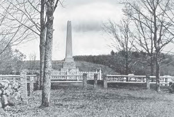
The Sudbury Fight, a brilliant victory for the native alliance, is marked in several locations throughout the town of Sudbury, Massachusetts. This grave marker, at Wadsworth Cemetery off Concord Road, commemorates the deaths of Captains Samuel Wadsworth and Samuel Brocklebank and twenty-seven of their men, and is near the spot where many of them fell. (From King Philip’s War, George W. Ellis and John E. Morris, 1906)
It was then that the natives lit the dry brush of Green Hill on fire, forcing Wadsworth and his men to flee from the choking smoke and chaos. As they retreated to the south, in the direction of Noyes’ Mill and the Goodenow garrison, most of the English, including Wadsworth and Brocklebank, were cut down; The Old Indian Chronicle records that “the Indians . . . came upon them like so many Tigers, and dulling their active Swords with excessive Numbers, obtained the Dishonor of a Victory.”262 As night fell the natives, having completed their rout, retreated to the west, leaving the frightened settlers scattered throughout Sudbury’s garrisons to wonder what fate would bring them in the morning.
The site of Noyes’ Mill is marked on Route 20, west of Concord Road, near the present-day Mill Village shopping center. The marker reads:
HOPBROOK MILL
TO THE LEFT IS THE SITE OF
HOPBROOK MILL, ERECTED IN 1659
BY VIRTUE OF A TOWN GRANT TO
THOMAS AND PETER NOYES, “TO
BUILD AND MAINTAIN A MILL TO
GRIND THE CORN OF THE SETTLERS.”
IT IS NOW THE PROPERTY OF
HENRY FORD.
While the distance to the summit of Green Hill is not great, it is far enough away to understand how so many of Wadsworth’s men were lost. With most of the English driven into garrisons, the area between the hill and the mill must have been alive with warriors.
The day after the battle Captain Samuel Hunting and his native troops, who had arrived on foot from Charlestown late the prior day, searched the area for the English dead, gathering the bodies of five of the Concord militia. These were buried in a common grave at the east end of Town Bridge.263 Also, early that morning, the garrison at Marlboro watched silently as the victorious natives shouted seventy-four times to indicate the number of English they believed were lying dead in Sudbury.264
Wadsworth, Brocklebank, and about twenty-seven of their men were buried in a mass grave described by Alfred Serend Hudson as about six feet square “in which bodies were placed in tiers at right angles to each other.”265 The spot was marked by a heap of stones, in part to deter wolves. In 1852 the remains of these men were excavated and moved fifty feet north to the site of a new monument. A state marker at Boston Post Road (Route 20) and Concord Road designates this memorial, which is four-tenths of a mile north on Concord Road at the Wadsworth Cemetery. The marker reads:
SUDBURY FIGHT
ONE-QUARTER MILE NORTH
TOOK PLACE THE SUDBURY FIGHT
WITH KING PHILIP’S INDIANS ON
APRIL 21, 1676. CAPTAIN SAMUEL
WADSWORTH FELL WITH TWENTY-
EIGHT OF HIS MEN. THEIR MONUMENT
STANDS IN THE BURYING GROUND.
The monument itself sits toward the back of the cemetery and reads:
THIS MONUMENT IS ERECTED BY THE COMMONWEALTH OF
MASSACHUSETTS AND THE TOWN OF SUDBURY IN GRATEFUL
REMEMBRANCE OF THE SERVICE AND SUFFERINGS OF THE
FOUNDERS OF THE STATE AND ESPECIALLY IN HONOR OF
CAPT. S. WADSWORTH OF MILTON
CAPT. BROCKLEBANK OF ROWLEY
LIEUT. SHARP OF BROOKLINE
AND TWENTY SIX OTHERS, MEN OF THEIR COMMAND, WHO FELL
NEAR THIS SPOT ON THE 18 OF APRIL 1676 WHILE DEFENDING
THE FRONTIER SETTLEMENTS AGAINST THE ALLIED INDIAN FORCE
OF PHILIP OF POKANOKET
1852
Samuel Wadsworth’s stone, set in 1730 by his son, Benjamin (then president of Harvard College), was moved with the bodies to the base of the new monument. It reads:
CAPT. SAMUEL WADSWORTH OF
MILTON, HIS LIEU. SHARP OF
BROOKLINE, CAPT. BROCKLEBANK
OF ROWLEY, WITH ABOUT
TWENTY-SIX OTHER SOLDIERS
FIGHTING FOR YE DEFENSE OF
THEIR COUNTRY WERE SLAIN
BY YE INDIAN ENEMY, APRIL 18TH
1676, & LYE BURIED IN THIS PLACE.
Several other garrisons not known to be actively involved in the battle on April 21 are designated in Sudbury. The Parmenter garrison is commemorated by a stone marker on Garrison House Lane, a dirt road on the north side of Boston Post Road (Route 20), about six hundred feet east of the entrance to the Wayside Inn. The marker reads:
NEARBY IS THE SITE OF
THE PARMENTER GARRISON,
A STONE HOUSE BUILT
PREVIOUS TO 1686 AND
USED AS A PLACE OF REFUGE
FROM THE INDIANS.
RAZED IN 1858.
ERECTED BY
WAYSIDE INN CHAPTER D.A.R
1906
The Parmenter garrison was a two-room, one-story structure.266 Tradition holds that workmen building the Wayside Inn retreated to this garrison at night for safety.267
The Brown garrison was probably built about 1660 by Major Thomas Brown268 and stood at the intersection of Nobscot and Dudley Roads. The structure, made of wood and lined with brick, was demolished in about 1855269 and no sign of it remains.
Other houses in Sudbury were thought to have been used as garrisons, though none remain. One of these, a blockhouse torn down in the early nineteenth century, was said by one observer to have bullet marks on it.270
The Sudbury Fight should have been one of the natives’ finest hours. The feint at the Haynes garrison, the ambush of the Concord men, the ambush of Wadsworth’s troops, the ability to seal off Green Hill from reinforcements, and the firing of Green Hill were as fine a display of military tactics as occurred during King Philip’s War. (If it could be proved that Philip had masterminded this battle—which it cannot—then it would lay to rest the question of his military prowess.) A victory this close to Boston, inside the Marlboro defense and standing toe-to-toe with English soldiers, should have given the Wampanoag, Nipmuc, and Narragansett warriors a tremendous lift. However, such was not the case.
Perhaps the natives took unacceptable losses. Perhaps the fact that Sudbury still stood, and English reinforcements continued to pour in from all directions, was disheartening. Perhaps the fact that the natives still found the garrisons to be nearly impossible to crack made the victory hollow. In any event, when the war party returned to its camp at Wachusett, Mary Rowlandson wrote:
To my thinking, they went without any scruple but that they should prosper and gain the victory. And they went out not so rejoicing, but they came home with as great a victory, for they said they had killed two captains and almost an hundred men. One Englishman they brought alive with them; and he said it was too true for they had made sad work at Sudbury, as indeed it proved. Yet they came home without that rejoicing and triumphing over their victory which they were wont to show at other times, but rather like dogs (as they say) which have lost their ears. Yet I could not perceive that it was for their own loss of men. They said they had not lost but above five or six, and I missed none, except in one wigwam. When they went, they acted as if the Devil had told them that they should gain the victory; and now they acted as if the Devil had told them that they should have a fall.271
Shortly after the Sudbury Fight the native alliances would splinter, with Philip returning to his homeland and native warriors concentrating their efforts not so much on war but on feeding their people.
By early May 1676, negotiations for the release of English hostages had stalled any coordinated offensive campaign by the colonial troops in the Connecticut River Valley. Meanwhile, settlers along the valley were growing restless and frustrated, as small bands of natives from the upper valley made repeated incursions, stealing livestock and making planting impossible. Public pressure for a renewed offensive grew.
The prospects for an aggressive campaign looked bleak. Captain William Turner, a tailor in Boston prior to the war, was stationed in Hadley with fifty-one men, many of them young, inexperienced, and, in George Madison Bodge’s estimation, “in great distress for want of clothing both Linen and Woolen.”272 An additional fifty-five men and boys, also poorly armed and supplied, were garrisoned in Springfield and Northampton.273 Turner himself was weak from sickness (perhaps the “epidemic distemper or malignant cold” spreading throughout the colonies,274 or residue from his long imprisonment as a Baptist at the hands of Massachusetts Bay authorities), and had asked to be relieved of his commission some time before.
What was most aggravating to many of the valley’s settlers was that a large native encampment was known to exist at Peskeompskut, present-day Turner’s Falls in the town of Montague. Turner coauthored a letter to the General Court on April 19, reporting that “it is strange to see how much spirit (more than formerly) appears in our men to be out against the enemy . . . [who] now come so near us, that we count we might go forth in the evening, and come upon them in the darkness of the same night.”275 The close encampment of which Turner wrote comprised three sites near the “upper falls” of the Connecticut. George Ellis and John Morris place one of these sites on “high ground on the right bank at the head of the falls, another on the opposite bank [possibly present-day Great Island],276 and the third on Smead’s Island, a mile [farther down the river].”277 The Indians living there, themselves short of food, were going about the business of fishing and planting, largely unmolested. Many were women, children, and the aged. If their activity were allowed to continue, the Nipmuc and river Indians would be refortified for an aggressive summer campaign.
Three events spurred the English to action. The first was the escape of John Gilbert, who had been taken prisoner in Springfield a month before. Gilbert was able to brief Turner on the size and makeup of the Peskeompskut camps and alert him to the natives’ slackened preparedness. Then, on May 12, warriors from Peskeompskut swept down into the valley, across the Hatfield meadow, and made off with a herd of seventy horses and cattle. This was a great loss to the English that turned frustration into anger. Three days later, Thomas Reed, a soldier captured near Hadley on April 1 and held at Peskeompskut, appeared in Hatfield to confirm Gilbert’s information. He added that the natives were also planting as far south as Deerfield, and that the huge camps included no more than “sixty or seventy fighting men . . . [who] were secure and scornful, boasting of great things they have done and will do.”278 The Connecticut Council of War nonetheless continued to balk at taking action, in part because the camp at Peskeompskut still held a large number of English hostages.
Despite the lack of support from Hartford, the ill preparedness of the English troops, and his own sickness, Turner decided that the time to strike had come. Calling for volunteers from Hatfield, Northampton, and Hadley, he assembled more than 150 mounted men at Hatfield. The group waited for several days in anticipation of additional reinforcements from Connecticut, but finally giving up hope, they began their twenty-mile march to Peskeompskut near sundown on May 18.
Turner’s men marched past the scene of the Hopewell Swamp fight, across Bloody Brook, along the same path that Beers had traveled, and through ravaged Deerfield, which they reached around midnight.279 An approaching thunderstorm, memories of the disasters that had occurred along their path of march, and fatigue must have taken some of the early excitement out of the expedition. Ellis and Morris relate, however, that they pressed on, crossing the Deerfield River at the “northerly end of the meadows, near the mouth of Sheldon’s Brook,” where they were almost discov ered by a native fishing camp at present-day Cheapside.280 The Indians appeared with torches to investigate the disturbance, but determined that a herd of moose must have crossed the river and returned to sleep.

William Turner’s surprise attack on the Native American camp at Peskeompskut, or present-day Turner’s Falls, Massachusetts, turned to near disaster for the English. Turner himself died in the helter-skelter retreat, and the spot of his death is marked today in Greenfield, Massachusetts. (Eric Schultz)
As the rain began falling and lightning lit up the sky, the troops crossed the Green River, passing the great ash swamp to the east, and reached the high ground just under Mount Adams at daybreak.281 Leaving their horses about a half mile from the falls, they crossed the shallow Fall River just above the site of the Old Stone Mill,282 near the Connecticut River,283 and marched up a steep hill above the upper Peskeompskut encampment.
All was quiet in the camp below: Hubbard says the natives “were almost in a dead Sleep, without any Scouts abroad, or watching about their Wigwams at Home; for in the Evening they had made themselves merry with new Milk and roast Beef.”284 Turner’s men rushed the sleeping camp, firing into the wigwams so quickly that the Indians had little time to respond. Some natives were shot and others were drowned while trying to escape across the river. Captain Samuel Holyoke, grandson of William Pynchon, discovered five Indians cowering in the rocks by the shore and killed them with his sword. As the warriors fled, more of the aged and young were indiscriminately massacred. Meanwhile, the camp was set on fire, food stores destroyed, and two forges used for the repair of guns hurled into the river.
To this point, the English had lost only one man. However, once the initial blow fell, the battle quickly began to turn. Turner had failed to station men at the crossing from Smead’s Island, where warriors were now springing into action directly in the path of the English retreat. Turner’s men had lingered too long in their destruction, and were now set upon by the same warriors they had chased from the camp. As the Indians pressed their attack, the inexperienced English panicked; their horses were almost stolen, their rear guard cut off and left to escape on its own, with the rest fleeing in disarray. A rumor that Philip had appeared with one thousand warriors quickly spread, adding to the frenzy.
Turner tried to lead a coordinated retreat, while Holyoke held the rear. At the Green River, near the mouth of Ash Swamp Brook, Turner was fatally shot at the river’s edge,285 near the site where Nash’s Mill was later built.286 This spot was commemorated in Turner Square, located at the upper end of Conway Street, at the junction of Silver Street in present-day Greenfield. A stone marker was erected there in 1905. When Interstate 91 was constructed, Fall Brook, a western spur of Fall River, was routed underground and the Turner monument removed to the town swimming pool near the Green River, thought to be a more accurate indication of where Turner fell. In the late 1980s a second, more detailed marker was erected near the first.287
About 1874, at a place described in Lucy Cutler Kellogg’s History of Greenfield as being “on the Lucius Nims farm near the Meadow road just south of the road to Nash’s Mills,” Judge Thompson uncovered human bones that he believed were those of Captain Turner. The bones had been buried on higher ground, away from the river. Judge Thompson stored them in a box in a nearby mill in the Nash’s Mills neighborhood; this mill eventually burned down, taking the bones with it.288
With Captain Turner fallen, the retreat continued, passing through Deerfield to Deerfield South Meadows and a place known as the “Bars.”289 All the while the natives kept pace, harassing and killing the terrified troops. Eventually, Captain Holyoke was able to reestablish some sense of order, and, says Hubbard, had he “not played the Man at a more than ordinary rate, sometimes in the Front, sometimes in the Flank and Rear, at all Times encouraging the Soldiers, it might have proved a fatal Business to the Assailants.”290
When the English troops reached Hatfield late in the morning, forty-five were missing. Six would straggle in over the next few days. Shortly thereafter Connecticut sent a company of eighty men under Captain Benjamin Newbury to bolster the Connecticut Valley towns.
Estimates regarding native losses ranged as high as three to four hundred,291 but the best guess might be one or two hundred, many being women, children, and old people.292 (Even Increase Mather admitted, “Victory was not so great as when first apprehended.”)293 However, worse than these losses, the fight at Turner’s Falls broke the back of native resistance in the Connecticut River Valley. Most of the Indians’ hard-earned supplies were lost. Their hope for a stable food source was gone. And their strategy of negotiating with the English to buy time had failed. There would be other attacks as King Philip’s War wound down, but military activities in the valley would become an entirely one-sided affair in the aftermath of the fight at Turner’s Falls.
The battle site at Turner’s Falls has changed dramatically since the days of King Philip’s War. Before the construction of dams, the water around the falls was one of the chief spawning grounds for shad and salmon. In History of the Town of Gill, Ralph Stoughton notes that Great Island, situated in the Connecticut River near the falls, “originally towered high above the normal water level, a rugged pinnacle of rock with a sheer drop on its western side to a lower expanse containing some three acres of fertile soil.”294 From Great Island to the Gill shore, a four-hundred-yard-long flume sped the river along; from Great Island to the Montague shore there formed a natural waterfall.
Today, Great Island is but a shadow of its former self, connected by steel and asphalt to the shore, sitting low to the water which quietly passes by on either side. Smead’s Island, located farther south, is today sometimes submerged underwater.
A monument at the intersection of Montague City Road and French King Highway looks down upon the scene of the fight and across to the village of Turner’s Falls. The rise of land behind the monument is the slope down which Turner’s men marched to attack the camp.
In August 1675, the military designated Hadley as headquarters for operations along the Connecticut River Valley. The town was fortified by troops, supplies, and a stockade that stretched from riverbank to riverbank, taking advantage of Hadley’s position along a bend in the Connecticut River. In “Seventeenth-Century Military Defenses Uncovered,” Rita Reinke recorded that in 1990 a team from the University of Massachusetts at Amherst, working with town records and deeds, discovered a small segment of this palisade when they uncovered “a ditch, at least one-and-one half feet deep, and three feet wide . . . and running parallel to it, was a shallower trench for the palisade’s posts.” (Evidence of the palisade had been first uncovered about 1905, when a local farmer was plowing on the east side of West Street Common.) Archaeologists noted that floods, construction, and farming would have obliterated much of this old fortification, but to have discovered a segment of it meant, according to Reinke, that “Hadley is now one of the few places in New England where the evidence of 17th century military defenses has been seen.”295
It was from this relatively secure position that the ill-fated troops under Captain Richard Beers would leave to evacuate Northfield, and those under Captain Thomas Lathrop would depart to evacuate Deerfield.
On June 12, 1676, Hadley was subject to a vigorous assault that quickly melted away when native warriors discovered—so most histories record—three hundred English soldiers and two hundred English-allied Indians on hand to meet them. The battle began in the early morning as three soldiers, unwisely leaving the settlement without their arms, came charging back toward the fortification pursued by twenty natives. Two of the soldiers were killed and the third mortally wounded. Soon a band of warriors was being engaged and driven back on the south side of the settlement, while at the north end of town, according to Increase Mather’s account, “a great Swarm of Indians issued out of the bushes, and made their main assault.”296 Some of the natives attacked a house where the inhabitants fired what Mather describes as a “great gun,”297 causing them to flee in panic. Finally, concludes Hubbard’s version of the event, the natives felt “such a smart Repulse, that they found the Place too hot for them to abide it.”298
When the Indians retreated en masse, they were pursued only a short distance. Both Hubbard and Mather, usually reticent in their criticism, questioned this lack of pursuit, and the loss of an opportunity to destroy so large a force.
The English reported that as many as seven hundred natives had attacked the settlement,299 but could find only three dead. Later reports, not necessarily reliable, indicated that the Mohawk may have fallen upon the warriors’ women and children while this attack was going on.300
While there is little disagreement among historians that Hadley was assaulted on June 12, 1676, there has been a great deal of controversy throughout the years as to whether Hadley also suffered an earlier attack, on September 1, 1675. Some notable historians were convinced that the September 1 attack occurred, and that colonial authorities participated in one of America’s first military cover-ups. Other historians, including most modern writers, claim that the attack on September 1 was a fanciful creation based on tradition and legend.
At the root of the controversy lies the presence in Hadley of Major General William Goffe, a member of the High Court of Justice that sentenced King Charles I to death in 1649. (Russell Bourne notes that, for Puritans, Goffe “was as close as a man could come to being a saint.”)301 In May 1660, when the exiled King Charles II was restored to the throne, Goffe fled to Boston, arriving there in July.302 The following February he moved to New Haven, Connecticut, accompanied by his father-in-law (and fellow regicide judge) Lieutenant General Edward Whalley. These two lived as fugitives in New Haven until October 1663, when they moved to the home of the Reverend John Russell at Hadley.303
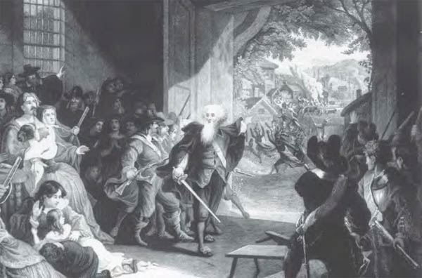
To add to the scene’s drama in this depiction of the Angel of Hadley, Chapman shows the natives inside Hadley’s palisade, even though all the destruction occurred outside the fortification. (Courtesy of the Hadley Historical Society)
According to tradition, few in Hadley knew that Goffe and Whalley were residents at the town’s parsonage for nearly ten years. In fact, Goffe would be successful in eluding the king’s agents, said to be searching the colonies for his presence, and die of natural causes many years after the end of King Philip’s War.
The only contemporary account of an extraordinary event occurring at Hadley on September 1, 1675, was written in 1677 by Increase Mather. The minister noted that the residents of the town “were driven from the Holy Service they were attending by a most sudden and violent Alarm, which routed them the whole day after.”304 Mather said nothing more about the event. William Hubbard, generally more detailed in his description of the war than Mather, failed to mention the alarm entirely. Increase Mather’s son, Cotton, who later wrote his own history of King Philip’s War, was as silent as Hubbard. Indeed, nothing more was heard on the subject—not from the minister Russell, Springfield’s John Pynchon, or in any records of the time—until 1764, nearly a century after the war, when Governor Thomas Hutchinson published his history of Massachusetts.
Hutchinson was in possession of Goffe’s diary, in which the general described his years of concealment as a fugitive. As Hutchinson recounted Goffe’s adventures, he added to his history what was described by George Sheldon as an “anecdote handed down through Gov. Leverett’s family.”305 It seems that when the alarm was sounded in Hadley on September 1, 1675, the frightened residents were thrown into confusion. Hutchinson wrote:
Suddenly a grave, elderly person appeared in the midst of them. In his mien and dress he differed from the rest of the people. He not only encouraged them to defend themselves, but put himself at their head, rallied, instructed and led them on to encounter the enemy, who by this means were repulsed. As suddenly the deliverer of Hadley disappeared. The people were left in consternation, utterly unable to account for this strange phenomenon. It is not probable that they were ever able to explain it. If Goffe had been then discovered, it must have come to the knowledge of those persons, who declare by their letters that they never knew what became of him.306
In his 1794 history, The Judges of Charles I, Ezra Stiles, the president of Yale College, embellished Hutchinson’s account, repeating the basic story but adding that the residents of Hadley felt they had been delivered by an “Angel of God.”307 Stiles’ account most certainly came directly from Hutchinson; the language seems too similar, and the story too consistent:
Suddenly, and in the midst of the people, there appeared a man of very venerable aspect, and different from the inhabitants in his apparel, who took the command, arrayed and ordered them in the best military manner, and, under his direction, they repelled and routed the Indians, and the town was saved. He immediately vanished, and the inhabitants could not account for the phenomenon, but by considering that person was an angel sent of God upon that special occasion for their deliverance; and for some time after, said and believed that they had been delivered and saved by an angel.308
With impeccable sources like Hutchinson and Stiles as their bedrock, historians repeated Goffe’s valiant rescue of Hadley for a century. With each retelling the assault grew more threatening, more detailed, and often more confusing. By 1824, one respected local historian had muddled the alleged attack of September 1 with the real attack on June 12 the following year.309 By 1859 another historian had decided that the attack took place on the east side of the village, since “an aged woman, in a remote part of town, says she had heard that Goffe saw the Indians entering the town from the mountains in the distance.”310 Later, it was revealed that Goffe had observed the Indians from his chamber, which had a window toward the east, and that the attack was “undoubtedly upon the outskirts of town.”311
While history was being adorned, some explanation for Mather and Hubbard’s silence had to be given. The theory of a colonial cover-up designed to protect Goffe and Whalley from the king’s agents was well suited to the task. Under this interpretation, Mather’s reference to an “alarm” was nothing less than a cryptic reference to the assault. The complete silence of Hubbard, so thorough in other respects, was proof positive of a colonial plot. Local historian Sylvester Judd believed Hutchinson’s account of the September 1 attack and concluded that “it was necessary at the time, and long after, to throw a veil over the transaction of that day.”312
In 1874, George Sheldon wrote a stinging critique of the attack on Hadley for The New England Historic Genealogical Register, tracing every known historical account back to Hutchinson. Why, Sheldon asked, would a cover-up need to include the attack itself, not simple silence on Goffe’s role? Why, if the appearance of Goffe had been so unique, would the tradition of the attack have been handed down only in Governor Leverett’s family? Indeed, Sheldon noted, Hutchinson had access to the personal papers of both Increase and Cotton Mather, and to Goffe’s personal diary, and yet he still had to rely on a Leverett family tradition as a source for his story. Sheldon concluded his detailed argument by writing that “there was no attack on Hadley Sept. 1st, 1675 . . . [and] that the story of General Goffe’s appearance either as man or angel, at any attack on the town is pure romance.”313
Most twentieth-century historians, no doubt reading Sheldon, have likewise been skeptical about a September 1675 attack. George Ellis and John Morris wrote that “the alleged furious attack on Hadley, which made it necessary for Goffe to take command of the panic-stricken settlers, never occurred.”314 Douglas Edward Leach noted that “the episode is legendary rather than historical.”315 Russell Bourne referred to the story as “the best example of Puritan writers’ creative efforts.”316 It would seem that the matter had been laid to rest, once and for all.
In 1987, however, Douglas C. Wilson published an article in the New England Quarterly casting doubt on Sheldon’s analysis and opening the door again to the conspiracy theory. First, Wilson noted, Goffe and Whalley had a wide and intricate network of connections within the colonies. Their friends included Daniel Gookin (who had crossed the Atlantic with them and harbored the two when they first reached New England), Governor John Leverett (who had fought under Whalley in England’s Civil War), Increase Mather, and a number of other important colonial leaders. These colonial leaders were ready and capable of hiding their guests from the king’s agents.
Second, Wilson concurs with Sheldon that an attack on Hadley on September 1 probably never occurred. However, by drawing on a letter from Hadley’s pastor, John Russell, written in 1677, Wilson conjectured that Goffe may have played a vital role in the real attack on Hadley in June 1676.
Sheldon had dismissed the need for Goffe’s assistance on June 12 because Hadley was alive with soldiers—some five hundred Connecticut men under Major Talcott. The truth, however, is that Talcott and his men were probably stationed across the river in Northampton.317 In addition, Mather’s description of the event is unclear, and several of his lines can be taken to imply that Hadley’s settlers were involved in repulsing the first wave of warriors. Unquestionably, Talcott himself was across the river in Northampton,318 which would help to explain why there was no order given to pursue the fleeing Indians.
Goffe’s role in the battle would have been protected by Mather and Hubbard, and also by the official military correspondence of Major Talcott (who was the brother-in-law of Goffe’s host, the minister John Russell). A few months after the battle, Goffe left for Hartford, a sign that his secret of twelve years might have been compromised.
Like many mysteries in King Philip’s War, the arguments concerning the “Angel of Hadley” weigh heavily on both sides, yet neither is entirely convincing. Conspiracy or legend, Goffe’s role in the attack on Hadley is another indication that historians of King Philip’s War often wrote more than history; it is only through the careful efforts of people like George Sheldon and Douglas Wilson that the rest of us know the difference.
On August 11, 1676, between 200 and 250 natives, intent on fleeing the war and seeking refuge with the Indians of New York, crossed the Chicopee River on rafts and headed for Westfield, Massachusetts. Major John Talcott and his Connecticut forces, which had been engaged in operations shortly before near Taunton, Massachusetts, were alerted by the settlers at Westfield to the native presence. Talcott followed in hot pursuit, eventually overtaking the refugees on August 15 at their camp on the western bank of the Housatonic River. Talcott divided his troopers, sending half to cross the river below the camp and approach from the west, while the remainder would attack from the east. This first band was spotted by a native fishing in the river; the Indian was killed immediately, but the shot cost the English an element of surprise. Despite this, at least thirty-five natives were killed and twenty captured.319 Hubbard wrote that others must have been wounded given the “dabbling of the Bushes with Blood, as was observed by them that followed them a little further.”320 Talcott, short of supplies, was forced to break off the chase.
Hubbard placed this massacre at the “Ausotunnoog River (in the middle Way betwixt Westfield and the Dutch River, and Fort-Albany).321 This area was wilderness in 1676, and would be for another fifty years. The town historian of Great Barrington, Charles Taylor, wrote in 1882 that “Talcot’s fight with the Indians is, we believe, the earliest occurrence connecting this section of country with history.”322 Therefore, determining the present-day location of the massacre is left to tradition and conjecture.
Taylor wrote of traditions that placed the massacre in Stockbridge, and in the “northeast part of Salisbury, at the locality now called Dutcher’s Bridge.”323 However, the most logical route that a large group of natives would take, proceeding in great haste west from Westfield toward the Hudson River, would cross the Housatonic River at the fordway by the so-called Great Wigwam in present-day Great Barrington. The precise location of the Great Wigwam, a ceremonial meeting place of the natives, is unknown, but thought to be near the site (in the 2010s) of the Congregational Church between Pleasant and Church Streets.324 The site of the massacre itself is designated on the west bank of the Housatonic River, near Bridge Street, by a large granite marker.
This image of Philip’s death—while dramatic—shows the sachem dressed to conform to nineteenth-century sensibilities, not to Benjamin Church’s more accurate but less modest description. (Courtesy of the Haffenreffer Museum of Anthropology, Brown University)