THE FIRST SIGNS OF WAR in the region of the Massachusetts Bay Colony that became present-day Maine began about three months after the outbreak of war in Swansea, Massachusetts, and took the shape of marauding rather than violent assault. The home of Thomas Purchase, a man characterized by Hubbard as “an ancient planter about Pegypscot River, and a known trader with the Indians,”1 was ransacked on September 5, 1675, the day after Richard Beers and his troops were ambushed in Northfield, Massachusetts. Hubbard says the Abenaki stole liquor and ammunition and killed livestock, but “offered no incivility to the mistress of the house.”2 They left, however, with the ominous warning that those coming after them “would deal far worse”3 with the English. Purchase and his family took heed and moved to Lynn, Massachusetts, after the incident.
While several traditions exist, the precise location of Thomas Purchase’s homestead can only be guessed. A history of Brunswick published in 1939 stated that Purchase may have lived on a knoll due east of the falls on the Androscoggin River once known as Fish House Hill.4 Purchase may also have had a residence at the head of New Meadows River, near where the Androscoggin River and Merrymeeting Bay meet.5
If the attack on the Purchase home was restrained, then the assault a week later on the Wakely family home in the area of present-day Portland was a tragic sign that King Philip’s War had come to Maine in all its fury. Thomas Wakely had been made a freeman of Massachusetts in 1636, so by the time of the war was undoubtedly an elderly man. Wakely and his family must have lived in an isolated location, for Increase Mather writes that they “lived many years in a plantation where there was no church at all,”6 and, as Hubbard reported, it took a day before soldiers could arrive to investigate “the fire they discerned the day before.”7 Hubbard described the gruesome scene they found at Wakely’s homestead:
The house burned to ashes, the bodies of the old man and his wife half consumed with the fire, the young woman killed, and three of the grand children having their brains dashed out . . . one girl of about eleven years old, was carried captive by them.8
The captive, Elizabeth Wakely, was freed in June 1676 and was still living in 1723.9
The present-day location of Wakely’s home is thought to be the east side of the Presumpscot River, three-quarters of a mile below the falls.10
Several other events associated with King Philip’s War occurred in present-day Portland, though their locations have been covered by urban construction. On August 11, 1676, almost a year after the assault on Thomas Purchase’s farm, the home of Anthony Brackett on the west side of the Back Cove was assaulted, with Brackett, his wife, and five children carried into captivity. A few days later his captors, who may have included Simon “the Yankee killer,” heard about the destruction of an important English trading post on Arrowsic Island (see below). Eager to share in the booty, the Abenaki became lax, allowing Brackett and his family to escape in an old birch canoe that Mrs. Brackett mended with a needle and thread.
Brackett’s home was located on Cleve’s Neck, now the downtown area of Portland. In the early twentieth century, George Ellis and John Morris reported that the cellar hole of the house was still visible on Deering Avenue a “few rods beyond the railroad crossing just north of Deering’s Oaks.”11 Today, however, this site is near the intersection of Routes 25 and 295, a completely developed area. No sign of the house exists.12
Likewise, the garrison of George Munjoy, used only briefly during the war, was located at the northwest corner of present-day Mountfort and Fore Streets.13 Its foundation is now buried under the sidewalk.
Once called Munjoy’s Island, present-day Peaks Island was the scene of an Abenaki ambush on September 3, 1676. A party of English attempting to secure sheep as food for their families were surprised and driven into the ruins of an old stone house on the southwest point of the island, four rods northeast of the Brackett family cemetery fence and a few rods from the channel separating Munjoy’s from James Andrews’ Island.14 All seven men were killed—some by stoning and others shot.15 Today, Peaks Island is reached by a twenty-minute ferry ride from Portland Harbor, and is Casco Bay’s most heavily populated island.
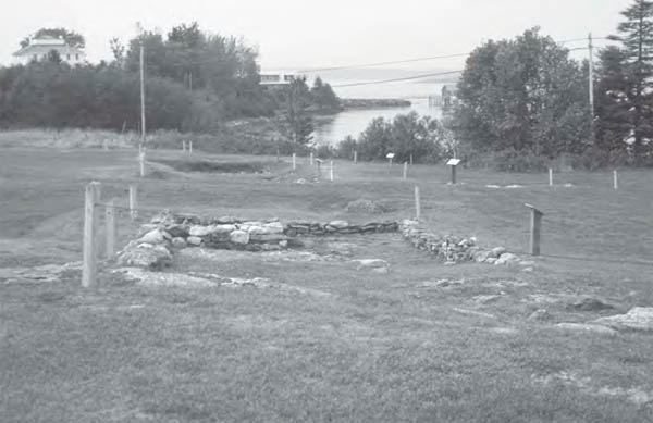
The Reverend William Hubbard referred to Pemaquid, Maine, as the “utmost boundary of New England.” Today, Colonial Pemaquid retells the story of Pemaquid, in part, through the preservation of its archaeological sites. (Eric Schultz)
Outside of Portland, attacks on English settlements continued in earnest throughout the fall of 1675 and into 1676. The house of Captain John Bonython, destroyed by Abenaki on September 18, 1675, was situated in present-day Saco along the Saco River. The site is shown on a 1901 map to be on the east side of present-day Hobson’s Lane (the oldest road in Saco), just before where the road turns toward the wharf.16 Today the site is covered by a landfill.
Bonython had abandoned his home prior to the attack, probably after being warned by a friendly Abenaki,17 and taken up a defense across the Saco River at Major William Phillips’ garrison, described in one Saco history as a “heavily timbered structure with an overhanging second story.”18 Within an hour of spotting the first smoke from the Bonython home, the fifty or so English huddled inside Phillips’ garrison were assaulted. Hubbard writes that at the first report of Abenaki activity, Phillips rushed to the window, and
another of his men, coming after, cryed “Master, What mean you, do you intend to be killed?” at which words he turned suddenly back from the window, out of which he was looking, when presently a bullet stuck him on the shoulder, grazing only upon it, without breaking the bone. The Indian upon the shot, thinking he had slain thereby (as they heard afterwards) gave a great shout, upon which they discerned that they were surrounded by them; whereupon they presently fired upon the enemy from all quarters, and from the flankers of the fortification, so as they wounded the captain of the Indians, who presently leaving the assault, retired three or four miles from the place.19
Hubbard continues, describing how the Abenaki spent the better part of the day destroying Phillips’ sawmill and corn mill, and part of the night constructing a cart filled with combustible material to fire the garrison. The cart, apparently similar to the one used at the assault on Brookfield, was wheeled out by moonlight at four or five o’clock in the morning. Phillips’ men
were a little discouraged at the site of this engine; but he bid them be of good courage . . . the cart, when brought a little nearer, became unwieldy by reason of the barricado planted in it, and being to pass through a small gutter, one wheel stuck fast in the slough, which brought the cart suddenly to the left, whereby the drivers lay open to the right flanker.20
Six Abenaki were killed and fifteen wounded, and with their captain mortally wounded some distance away, the siege was ended. However, the exposed position of the Phillips garrison also forced the English to abandon it. Soon after, the house was burned to the ground.21
The present-day site of the Phillips garrison is in Biddeford, Maine, on the west side of Pierson’s Lane, about halfway up the hill from Water Street.22 The neighborhood is now made up of two- and three-story apartment buildings.
The house of Richard Tozer at the old settlement of Newechewannick (present-day Berwick, Maine) was attacked on October 1, 1675, by two Abenaki, Andrew (of Saco) and Hope-Hood.23 Fifteen women and children were trapped within the house, says Hubbard, and only through the courage of
a young maid of about eighteen years of age . . . who being inbued with more courage than ordinarily the rest of her sex used to be . . . first shut the door, whereby they were denied entrance, till the rest within escaped to the next house, that was better fortified; that young Virago kept the door fast against them so long till the Indians had chop’d it in pieces with their hatchets; when entering the house, they knocked the poor maid down with their hatchets, and gave her many other wounds, leaving her for dead upon the place.24
After leaving the house, Andrew and Hope-Hood killed a three-year-old and captured an eleven-year-old. Miraculously, the “young maid” recovered from her wounds and was eventually “restored to perfect health again.”25
Tozer’s home was located about a mile from present-day Salmon Falls, New Hampshire, in present-day Berwick, Maine. This structure was known for years as the Old Garrison House and survived until the 1850s. Today, a nineteenth-century farmhouse sits on the exact location of the old cellar hole. The home can be seen on the west side of Route 236, at the top of the hill, about six-tenths of a mile north of the Boston and Maine Railroad tracks.26
On October 16, 1675, the Abenaki returned to Tozer’s home, killing Richard Tozer and capturing his son. Lieutenant Roger Plaisted, in command of the nearby garrison, sent seven men to rescue Tozer and his family. The party was ambushed, with two killed and the remainder barely able to reach the garrison. As Hubbard’s account of the war in Maine continues, the following day Plaisted led a party of twenty men to locate and bury the dead:
They were first to the furthest place, where they found Ro. Tozers body, and put it into their cart; but coming back to take up the other two bodies, which were fallen in a little swamp nearer to the garrison, they were set upon by an hundred and fifty of the enemy, that had hid themselves in the bushes, and under the stone-wall.27
Plaisted’s band was forced to retreat, though Plaisted, “disdaining either to fly from or yield himself,”28 fought to the death. His eldest son and a third man were also killed, and another son mortally wounded.
The Plaisted garrison was situated near the Tozer home, on the same side of Route 236, about two-tenths of a mile from the railroad tracks. A new house today stands on the site of the old cellar hole. On the east side of Route 236 nearly three-tenths of a mile from the tracks is a nineteenth-century marker designating the spot where Roger Plaisted and his son were killed. This tombstone is just off the road, surrounded by a small iron-bar fence.29 (This should not be confused with a small family burying ground just a few yards to the north.) The stone has fallen and is difficult to see without walking a short distance into the woods.
On August 13, 1676, the fortified house and trading post of Richard Hammond was attacked and destroyed by Abenaki warriors. Hammond and fourteen others lost their lives.30 Only a young woman, either a servant or Hammond’s daughter, fled in time to escape the assault. Hammond, described by Hubbard as “an ancient Inhabitant and Trader with the Indians up Kennibeck River,”31 was known for cheating his native customers, and the attack, says another historian, was marked by “particular ferocity.”32
The precise location of Hammond’s trading post was disputed for many years. The Reverend Henry O. Thayer finally established the location of Hammond’s property through his research, writing that “it can be rebuilt in fancy upon the northeastern curve of Long Reach where are now grouped the village dwellings of Day’s Ferry.”33 More precisely, Hammond’s home and trading post were located on the east side of the Kennebec River, slightly northwest of the intersection of Route 128 and Old Stage Road in present-day Woolwich. Some excavation has been done, though the site is difficult to locate precisely without assistance and is now on private land.
The trading post of Thomas Clarke and Thomas Lake, two wealthy Boston merchants, was situated on the eastern edge of Arrowsic Island, along the Sasonoa River between present-day Mill Island and Spring Cove, near the town of Woolwich, Maine. Clarke and Lake had purchased the four-mile-long island in its entirety in 1657, building up a prosperous trade in lumber, fish, cattle, and furs along one of the Indians’ well-traveled canoe routes. The trading post was large and in many ways self-sufficient. Hubbard described it as having
convenient Buildings for several Offices, as well for Wares and Trading, as Habitation: six several Edifices are said to have been there erected. The Warehouse at that Time was well furnished with all Sorts of Goods; besides a Mill and other Accommodations, and Dwellings within a Mile of the Fort and Mansion House.34
The trading post was also well armed, though not to the extent of a true military fort.35 Nonetheless, Hubbard conjectured that “had it been carefully defended it might have proved the Defense and Security of all that Side of the Country.”36
In the early morning of August 14, 1676, fresh from their raid on the Hammond house, the Abenaki took advantage of a careless sentry to spring a lightning attack on the trading post. Hubbard reported, without explanation,37 that the natives followed the sentry “in at the Fort-Gate,”38 which must have been left open, “while others of them immediately seized the Port Holes thereof, and shot down all they saw passing up and down within the Walls, and so in a little Time became Masters of the Fort, and all that was within it.”39 Thomas Lake, sensing the futility of fighting, fled with his agent, Sylvanus Davis, and two other men “out at a back Door, whereby they escaped to the Water-side, where they found a Canoe, into which they all entered and made away toward another Island near by.”40 Their flight did not go unnoticed, however, as the natives launched a canoe in pursuit. Lake and his men reached the shore of Mill Island—about five-eighths of a mile distance—but not before Davis was wounded. Unable to run or fight, Davis hid in ‘the Cleft of a Rock hard by the Place, where he first landed.”41 Two days later he emerged and escaped by canoe. Davis would survive the war, and it was likely his account from which Hubbard drew his description of the attack.42 Hubbard records that the two other men with Lake safely escaped by foot, perhaps being younger than the sixty-one-year-old merchant. Lake, unable to elude his pursuers, was shot and killed near the spot where the canoe landed. Six months later, in February 1677, an expedition under Major Richard Walderne would discover Lake’s body in almost perfect condition, “preserved entire and whole and free from Putrefaction by the Coldness of the long Winter,”43 and transport it to Boston. There, it was interred at Copp’s Hill Burying Ground, where Lake’s gravesite is still visible today.
Having driven the English out of the fort, the natives stole or destroyed everything of value, including several structures outside of the fortification. Their victory was complete, having taken (possibly without loss) the best-fortified settlement in the region and gaining huge stores of food and supplies in the process. In addition, the victory took a huge psychological toll on the area; Hubbard reported that when news of the disaster at Arrowsic spread, “all the plantations of the English in those Parts were soon after left, and forsaken by Degrees.”44
The location of the Clarke and Lake trading post was discovered in the 1890s by the minister Henry O. Thayer, who proceeded (in a not very scientific way) to excavate portions of the site. Thayer’s announcement of his discovery also led to several generations of treasure hunters, who destroyed portions of the site for future archaeologists. Fortunately, professionals began excavating the site in 1967, and by 1970 Professor James Leamon and his students from Bates College were exploring the site on an annual basis as part of a six-week course in historical archaeology.45 Today, the Clarke and Lake site is one of only a handful of English sites from the seventeenth century to have been extensively excavated in Maine.46
After excavating a portion of the site, Thayer wrote that “relics have been gathered, implements found, bones exhumed, flagstones of old pathways uncovered.”47 Thayer also discovered a brass sword hilt, since lost, and an unidentified iron artifact left in the possession of the Woolwich Historical Society.48 Unfortunately, he left no plan of his work, and modern archaeologists are left to guess at the precise location where Thayer dug.
The best and most complete summary of the history and archaeology of the site is The Clarke and Lake Company: The Historical Archaeology of a Seventeenth-Century Maine Settlement, published by Emerson W. Baker in 1985. In it, Baker reviewed the discovery of six seventeenth-century structures, reported in detail on many of the artifacts found, and wove the findings into a historical interpretation of the site.
Among the discoveries was a large collection of prehistoric artifacts, indicating the presence of natives for thousands of years prior to the English settlement on Arrowsic. Historic artifacts included a brass “posey ring,” common to colonial sites, mingled with calcified human hand bones; these bones, along with some nearby pieces of badly burned skull, were probably those of one of Clarke and Lake’s employees killed in the August 1676 attack. These are the only human remains uncovered at the site (except for perhaps Thayer’s report of “exhumed bones”), and the burial site of the settlers has never been located.49
More than seven thousand nails and nail fragments have been unearthed, and Baker conjectured that they may have been manufactured at the Saugus Iron Works in Massachusetts.50 Clarke and Lake’s two cannons were removed by Walderne’s party in February 1677, when any working firearms overlooked by the Abenaki would also have been collected. However, evidence of the trading post’s arsenal has surfaced in the form of a side plate to a snaphance pistol, a trigger guard from a musket, several musket balls, pieces of birdshot, and enough flint and chipping debris to indicate that flints may have been produced at Arrowsic.51 Less exotic, but equally important, numerous artifacts related to daily living—buttons, buckles, pipes, stoneware, pewter, spoons, candleholders, clay marbles, a razor, a Jews’ harp, spurs, and coins—have been uncovered at the site.
The first English expedition intended to destroy the Indian fort in the area of present-day Ossipee, New Hampshire, was planned in December 1675, at about the same time as the Great Swamp Fight. The tactics were identical: Catch the Abenaki off guard, smash their winter quarters, and destroy their ability to wage war in the spring. However, the northern weather was uncooperative. Hubbard reported that the winter was so hard that “it was not possible to have marched a Days Journey into the Woods, without hazarding all their Lives that should venture up: The Snow being found generally in those Woods four foot thick on the tenth of December.”52
The following year operations began a month earlier, so that by November 1, 1676, 130 English and 40 Christian Indians under Captains Hawthorne and Sill began their difficult four-day march to Ossipee.53 The fort they sought to attack had been built between 1650 and 166054 by some English tradesmen (possibly from Dover, New Hampshire, or Saco, Maine55), hired by the Indians to construct a defense against the Mohawk. Hubbard says the sturdy fort was built fourteen feet high with flankers at each corner.56 When Hawthorne and Sill arrived, the fort was deserted; they proceeded to burn it, and sent a scouting party farther north to see if any natives could be found. Discovering none, the entire party headed home, “having run,” concludes Hubbard, “more hazard of their limbs, by the sharpness of the frost, than of their lives by an assault from their enemies.”57
This scene has changed dramatically in the last three hundred years. Today, where the fort once stood, is the second tee of the Indian Mound Golf Course in Ossipee.58 It is the property of the Ossipee Historical Society. No recent archaeology has been conducted at the site, but work in the early nineteenth century concluded that the fort had included a palisade of about an acre in dimension.59
The fort at Black Point (present-day Scarborough, Maine) was the scene of one of Mugg Hegone’s greatest military victories, and later, the scene of his death. Mugg, who styled himself “of Saco River,” and was described variously as chief of the Androscoggins, principal minister of Madockawando, and prime minister of the Penobscot sachem,60 was active as a military leader during King Philip’s War. Mugg knew the English, having lived among English families for some years,61 so he also took on the role of diplomat, even traveling to Boston on a peace mission.
On October 12, 1676, between fifty and one hundred warriors attacked the garrison at Black Point, which was considered by the English, according to Hubbard, to be so strong that “a few Hands might have defended against all the Indians on that Side of the Country.”62 Captain Henry Jocelyn owned the garrison, and, in the absence of Captain Joshua Scottow, headed its defenses; like John Pynchon of Springfield, he was a successful merchant and influential man, but a poor soldier. (A letter from Jocelyn to Scottow in August 1676 reported “ye averseness of the generality of ye Inhabitants to obey military orders.”63) When Mugg called Jocelyn out to discuss peace, the sachem offered to let all of the English leave with their possessions if the fort were surrendered peacefully. Jocelyn, who might have resisted the parley in the first place, retreated to the fort to present the offer. There, he discovered that all but his household servants had fled the garrison by boat. Unable to defend the fort, he surrendered. (Jocelyn was treated kindly and released the following spring.) Mugg Hegone and his force had taken Black Point without losing a man.
Having little use for the garrison, the natives deserted Black Point by November, and by early the following year the English had reoccupied it.64 By May 1677, Lieutenant Bartholomew Tippen had command of the fort, and on May 14 Mugg Hegone and his forces again laid siege to it. This time the English resisted while the warriors mounted a fierce assault, killing three soldiers and capturing a fourth. The assault lasted three days until, on May 16, Lieutenant Tippen noticed the fatal wounding of a warrior observed to be “very busy and bold in the Assault,” says Hubbard’s account, “whom at the Time they deemed to be Simon, the arch Villain and Incendiary of all the Eastward Indians, but proved to be one almost as good as himself, who was called Mugg”;65 Mugg’s death “damped the Courage of all of his Companions”66 and the siege was lifted.
On June 22, 1677, Captain Benjamin Swett and Lieutenant James Richardson led a force of forty English—described by Hubbard as many “young, raw and inexperienced Soldiers, who were not able to look Danger, much less Death, in the Face”67—and two hundred friendly Indians (from the Natick, Massachusetts, area)68 on an expedition to Piscataqua. Sailing to Black Point on June 28, they received intelligence that a large body of natives were nearby. The next morning Swett and Richardson led a force ashore and were joined there by men from the Jocelyn garrison.
The lessons of the war had unfortunately been lost on Swett, and the presence of friendly Indians was of no help. Swett’s soldiers caught sight of some fleeing warriors, pursued them nearly two miles from the fort to a hill, and found themselves in the midst of a blistering ambush from swampland on either side of the hill. In Hubbard’s account, the young soldiers panicked and scattered, while “a few resolute Men of Courage bore the Brunt of the Service till they were in a Manner all knocked down.”69 Richardson was killed and Swett, victim of twenty wounds, fought his way almost back to the garrison before falling. When it was over twenty friendly Indians and forty English lay dead,70 including Swett and Richardson.
The scenes of these various encounters are today part of the Prouts Neck Wildlife Preserve and Bird Sanctuary in Scarborough. A marker for Jocelyn’s garrison can be found one-tenth of a mile past the post office on the west side of the Route 207 extension. It reads:
GARRISON COVE
SITE OF THE
JOCELYN (OR SCOTTOW) FORT
HEADQUARTERS FOR DEFENSE
FIRST INDIAN WAR
CHIEF MOGG HEIGON
KILLED HERE IN AN ATTACK
MAY 1677
Also in the wildlife preserve is Massacre Pond, which commemorates Benjamin Swett’s disastrous defeat. The ambush probably occurred some distance northeast of the pond near Moore’s Brook. A common grave is said to lie at the southwest corner of Massacre Pond, though no marker commemorates the ambush, and signs discourage visiting this residential area.
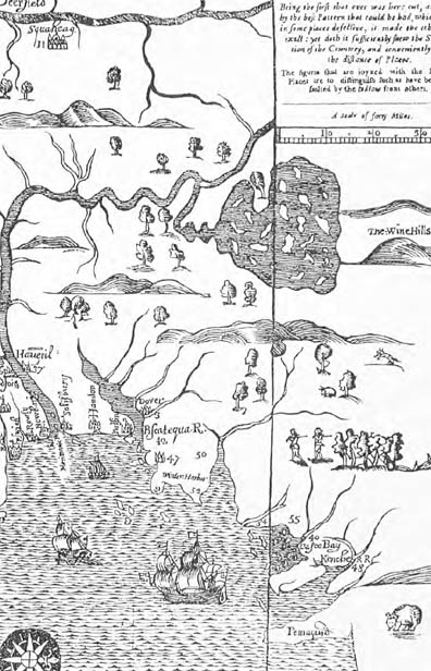
A section from “A Map of New England,” produced by John Foster of Boston around 1677. (Courtesy of the John Carter Brown University)