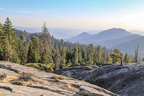
hiking through the Giant Forest
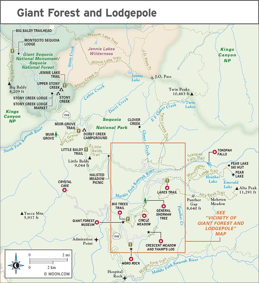
Exploring Giant Forest and Lodgepole
hiking through the Giant Forest
Look for S to find recommended sights, activities, dining, and lodging.
S Explore the Giant Forest Museum: This beautiful museum features informative exhibits about the surrounding giants. It’s also a good spot to visit with a park ranger (click here).
S Look up at General Sherman Tree: Join hundreds of revelers to gawk at the largest living tree on earth (click here).
S Ascend Moro Rock: Climb 400 stone stairs to reach exhilarating views of the High Sierra and San Joaquin Valley (click here).
S Go Underground at Crystal Cave: Take a guided tour to see this cave’s unique marble formations for yourself (click here).
S Hike to Tokopah Falls: It’s a fairly flat hike to this ripping waterfall, where you might hear pikas chirping (click here).
S Follow the Lakes Trail: It’s a rare opportunity to be able to hike to an alpine lake not far from a major road; this trail gives you the chance to stop at four different ones (click here).
S Walk the Big Trees Trail: Follow this paved loop that circles Round Meadow to enjoy the sights of sequoias, wildflowers, and wildlife (click here).
S Hike around Circle Meadow: The Congress Trail circles this less-visited meadow, showing off a quieter side of Giant Forest (click here).
S See Crescent Meadow and Tharp’s Log: This dazzling alpine meadow hike gets you up close and personal with a fallen sequoia that was converted into a home in the 1860s (click here).
Tharp’s Log.
If you only have one day in Sequoia National Park, Giant Forest is your stop. After realizing no two sequoias are the same, you’ll return again and again, to meet them all.
Why not start with the largest living thing on earth, the General Sherman Tree? From there, take a short trip along the Congress Trail to meet more forest denizens (noisy chickaree squirrels and a variety of woodpeckers), not to mention clusters of sequoias. This special forest is open all year, for hiking in the warmer months and snowshoeing in winter, and there are plenty of paved, flat trail options too. Follow the road out to Crescent Meadow to climb Moro Rock for great views or visit the “tree you can drive through.” To really understand the foundation of the park, take a guided tour into Crystal Cave, a miraculous vein of limestone transformed into stunning underground rock formations.
The larger Lodgepole area offers hikers a surplus of beauty, from Tokopah Falls to high meadows, lakes, and granite domes. Many people pass through Lodgepole, gazing at the big trees from their car on the way to somewhere else—but this is a mistake. Stop and give yourself time to truly admire the natural wonders before you. These trees have been stretching to the sky for thousands of years. And, believe it or not, the trees aren’t the oldest natural marvels you’ll encounter. Older still is the granite carved by glaciers. You could spend an entire lifetime admiring the magnificent landscape. After a full day, the perfect way to relax is a nice meal at the Peaks in Wuksachi Lodge or a barbecue at Wolverton Picnic Area. For those on a budget, set up your tent at Lodgepole Campground. The sites next to the Marble Fork of the Kaweah River are so peaceful that the rangers live here, too.
The landscape consists of many little enclaves here: the sunny slopes surrounding Dorst Creek and Wuksachi Lodge, the nestled canyon of Lodgepole, and the expansive circle of big trees in Giant Forest. Luckily, everything is within 40 minutes of each other, thanks to the area’s shuttle system.
With a full day in Giant Forest and Lodgepole, you can easily hit most of the area’s highlights. Start the day with a visit to the General Sherman tree then take the shuttle to the Big Trees Trail or meander along Congress Trail. If you’re hungry for some background on the park, pop by the Giant Forest Museum. In the afternoon, pack a picnic and head to Beetle Rock for a late lunch with a view of Lodgepole. Time permitting, you could tack on Tokopah Falls in early summer.
To tour Crystal Cave, you’ll need to budget at least half a day. The temperature of the cave is a cool 50°F (10°C), unaffected by the external weather. Pack layers, even in the summer.
Over a weekend, you can split your time between Giant Forest on your first day and around Lodgepole on the second. Traveling between the two areas is easy on the shuttle, but it’s not always the most efficient mode of transportation. Though weekends are crowded on Moro Rock, the view from the top is worth it. If you’d like fewer stairs and people but equal vistas, try Beetle Rock or a bigger hike to Little Baldy. For more views after a challenging climb, opt for Alta Peak. With a week, you will have the freedom to explore, try something new, and enjoy everything this area has to offer—all without feeling rushed.
Most park visitors come in the summer, but Lodgepole has enough room for everyone. Between Memorial Day and August, every campground and trail fills with people. Late August is when the crowds begin to thin. This is a great time to visit, as the weather is excellent through October. Autumn (Sept.-Oct.) brings brisk, starry nights and even fewer crowds, but most waterfalls dry up and trails can be quite dusty. Winter (Nov.-Feb.) is a quiet time, when you can admire the snowy landscape. You’ll need to brave the bitter cold and icy driving conditions, though. In spring (Mar.-May), the snow melts and wildflowers and dogwoods bloom. This is an ideal time for photographers to visit, as there will be few other visitors in the park.
Stop by the Lodgepole Visitor Center (63100 Lodgepole Rd., 559/565-4436, www.nps.gov/seki, 7am-5pm daily May-Nov.) for informative videos, planning information, and helpful tips from local guides and rangers. The theater shows a 20-minute video that offers information on the area’s history. The wilderness desk can advise on the best day hikes, set you up with an overnight backcountry permit, rent out a bear canister, or discuss trail conditions. Also at the visitors center is a bookstore run by the Sequoia Parks Conservancy, selling souvenirs, books, and stuffed animals. The visitors center is conveniently located at the first turnoff for Lodgepole, next to the market and less than half a mile from the campground. It’s a great place to park your car and hop on the shuttle to the more crowded Giant Forest trailheads.
Wheelchairs can be rented for free from the visitors center (and the Giant Forest Museum) and can be used anywhere in the parks. You will need to provide your name and phone number and return the wheelchair at the end of the day.
The Giant Forest Museum (Hwy. 198, 16 mi/26 km north of Ash Mountain entrance, 559/565-4480, www.nps.gov/seki, 9am-6pm daily mid-May-mid-Nov., 9am-4:30pm daily mid-Nov.-mid-May) offers visitors a chance to get to know the largest trees in the world through interesting exhibits on size comparisons, fire ecology, and history. Visit with rangers stationed at the front desk or participate in a ranger program in front of the Sentinel Tree. Stop in the small bookstore, which features books of all kinds, jewelry, hand-thrown pottery mugs, stuffed animals, and coloring books.

The museum’s central location makes it a great jumping off point for hikes. Here you’ll also find water fountains and restrooms. There’s an accessible parking lot just west of the museum. Across the street you can get beautiful sunset views from Beetle Rock. The only thing missing here is food.
The vehicle entrance fee is $35 for Sequoia and Kings Canyon National Parks. Giant Forest and Lodgepole are accessible from the Ash Mountain entrance in the Foothills region or by driving south along the Generals Highway from the Big Stump entrance at Grant Grove.
Take a guided day trip of Giant Forest with Sequoia Sightseeing Tours (559/561-4189, www.sequoiatours.com, $99 children, $149 adults, cost covers park entrance fee). Offering an insider’s experience of this part of Sequoia National Park throughout the year, the tour also includes a picnic lunch. Tours depart from Three Rivers. Another tour option visits Kings Canyon.
The Generals Highway (Hwy. 198) stretches from Grant Grove in the north to the Foothills in the south, but this 19-mile (31-km) scenic drive covers just the greatest hits of the Lodgepole and Giant Forest sections, spanning from Dorst Creek Campground to Crescent Meadow. Traffic permitting, it can take as little as an hour to drive this section, but if you stop at all the sights along the way, budget up to four hours so you’re not rushing. (For more details on the northern portion of the drive, see the Grant Grove chapter. To continue south, see the Foothills chapter.)
Start your drive at Dorst Creek Campground. Turn onto Dorst Creek Road and park along the side of the road after about 0.2 mile (0.3 km). Hop out of the car and look to the east to check out beautiful Dorst Creek Meadow, speckled with wildflowers in spring. At the end of the campground road, you can hike the Muir Grove Trail to better explore this area.
Exit the campground and turn right to head south on the Generals Highway for 5 miles (8 km). On the right is a pullout marking the Halstead Meadow Picnic Area. It’s worth a stop, especially in the early spring, to look for resident black bears foraging for grasses.
Continue heading southeast along the Generals Highway and enjoy the next 2 miles (3 km) of rolling, beautiful road. As your car dashes between the slanting light of this open forest, look for signs of past forest fires. Turn left onto Wuksachi Way and drive for about half a mile to reach Wuksachi Lodge. The road climbs above a granite ridge and reveals the peaks of the Silliman Crest and the upper watershed of the Marble Fork of the Kaweah River. The Wuksachi people once lived in this canyon; one of the last fluent speakers of the Wuksachi language, Eddie Sartuche, helped name the lodge. Stop at the lodge to visit its gift shop, or enjoy a bite at the elegant restaurant, The Peaks.
Head back the way you came on Wuksachi Way, then turn left to get back on the Generals Highway heading east. Continue another 2.3 miles (3.5 km) and turn left to reach the Lodgepole section of the park. Friendly rangers are on staff at the Lodgepole Visitor Center, ready to answer questions. If you’re interested in adding a hike to your stop, you can access the trail to Tokopah Falls from this area. If you need a snack, stop into the Lodgepole Market Center.
Now it’s time to make your way into the Giant Forest. From Lodgepole, turn left to head south again on the Generals Highway. In 1.5 miles (2.5 km), turn left onto Wolverton Road. Continue along the road for another 0.5 mile (0.8 km), then turn right, following signs for the General Sherman Tree. It’s another 0.7 mile (1.1 km) on this road to reach the parking lot. Hop out of the car to pay a visit to the General Sherman Tree, the largest living tree on the planet. After you’ve craned your neck to admire General Sherman’s beauty from all possible angles, you may want to check out the nearby Congress Trail to get a feel for this part of the forest.
Return to your car and exit the parking lot. Turn left onto Wolverton Road, then left again to get back on the Generals Highway heading south. This part of the road winds through the dappled shadow and sunlight of the Giant Forest. The sequoias loom above. The temptation to reach out and touch them is great. Drive slowly, windows open or top down. After 2.7 miles, you’ll reach the Giant Forest Museum, a grand modern tribute to the trees. On the left of the museum is a beautiful lookout spot called Beetle Rock.
If Crescent Meadow Road is open, take the left turn after the Giant Forest Museum. (The road is closed to vehicles on summer weekends and holidays. During this time, you must take a shuttle to get to any of the sites along the road.) This 1.8-mile (3-km) spur road offers amazing views as it skirts the southern end of Giant Forest, ending at Crescent Meadow. Sights along the way include Moro Rock, Tunnel Log, and several named sequoias like the Colonel Young Tree, the Booker T. Washington Tree, and the Roosevelt Tree. From Crescent Meadow, you can walk along the flat path to Tharp’s Log.
TOP EXPERIENCE
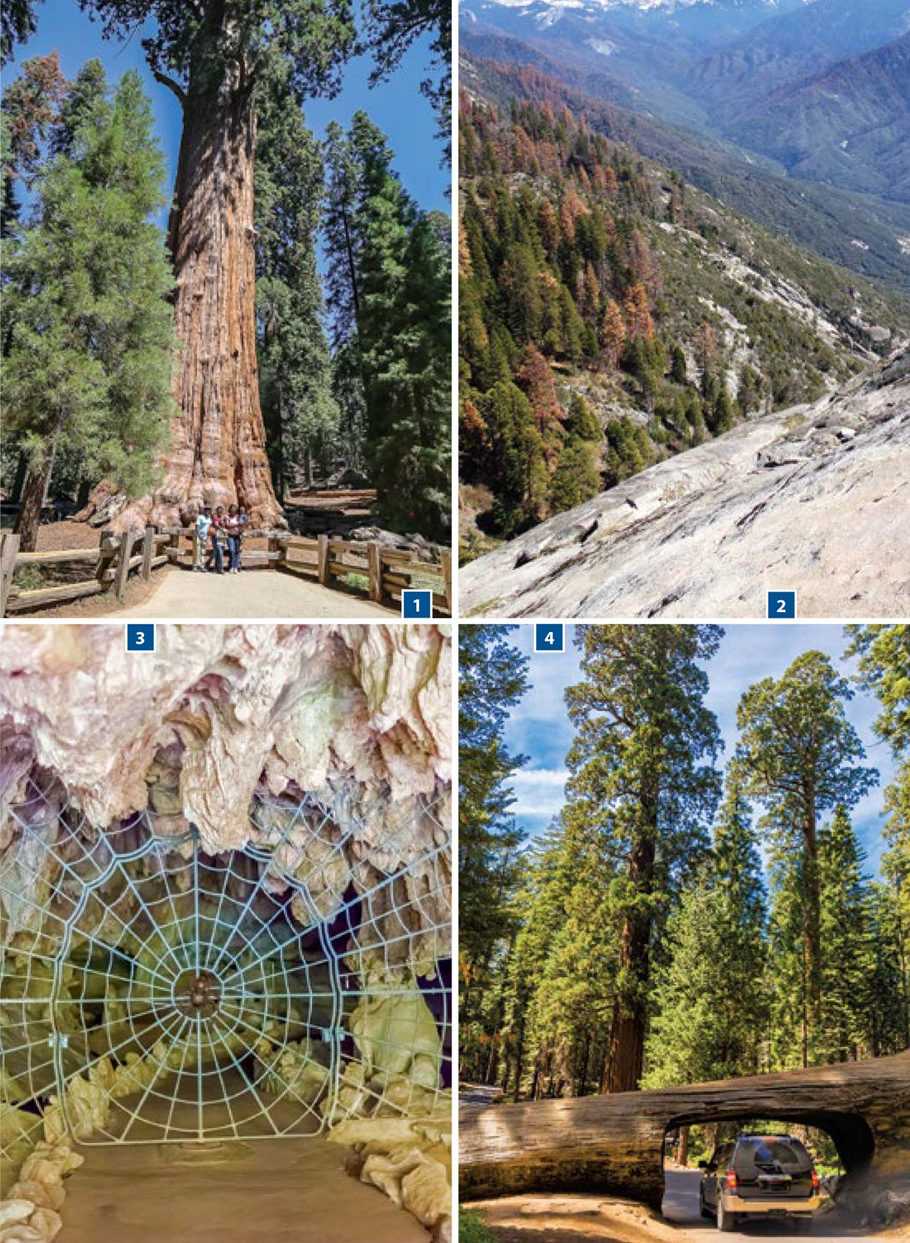
At the windy northern edge of a sunny, open part of the forest, the General Sherman Tree is a magnificent natural wonder. It’s the largest living tree on the planet—275 feet tall, over 36 feet wide at its base, and weighing an estimated 2.5 million pounds. About the size of the Statue of Liberty, this tree is estimated to be 2,300-2,700 years old. You can easily visit the tree in 15-30 minutes, but you’ll likely want more time to spend gazing in awe.
As many as 500 people will visit the tree within an hour during high season, so be prepared to wait for your photo op—or simply go to the back side of the tree. General Sherman is distinguishable from the other trees by its sheer size, so you won’t need to see the name plate on the front.
The park service has made visiting the tree easy for everyone. The main parking lot is off Wolverton Road. It opens onto a 0.5-mile (0.8-km) path to the tree; it’s paved, but has a few stairs along it. There’s also a parking lot designated for visitors with disability placards. From this lot, there’s a wheelchair-accessible path to the tree. The shuttles stop at this accessible lot as well as the main lot.
TOP EXPERIENCE
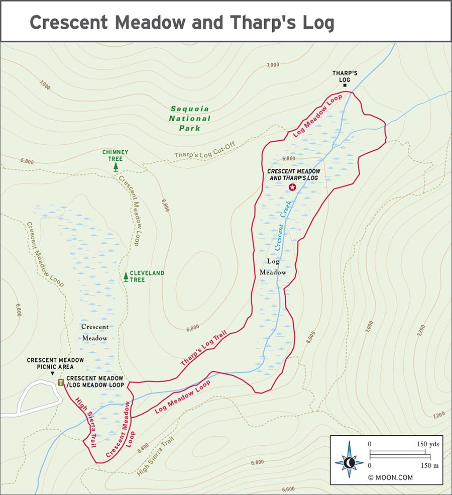
The granite dome known as Moro Rock protrudes over a mile above sea level and thousands of feet above the surrounding landscape. You can climb to the top of this rounded bulb to gain panoramic views from the Sierra Nevada peaks to the Central Valley below. This is a strenuous, short climb: 400 granite stairs ascending 300 feet (90 m) in a very short distance. It takes about 20 minutes to complete, but the views along the way and at the top are so grand you will want to allow for at least an hour for your trek.
Moro Rock is conveniently located near Giant Forest Museum. Shuttles (Gray Route, 8am-6pm daily summer, free) depart from the Giant Forest Museum every 20 minutes for the half-hour trip. The road to Moro Rock, Crescent Meadow Road, is closed to vehicles summer weekends and holidays from 8am-7pm. During this time, shuttles are the only way to get beyond the Giant Forest Museum to Moro Rock. In the shoulder seasons and on summer weekdays you may drive the road and try to find a spot in the small parking lot.
In the summer, you can meet a ranger at the top of Moro Rock (10am daily). Rangers will answer questions and provide information about the geology of the Sierra Nevada. Kids and adults alike enjoy the opportunity to hear more about the area. Note that this is an especially crowded time of day to visit Moro Rock. For the best experience, go at dawn or dusk to avoid the crowds—and to get better photos.
Many motorists are interested in the “tree you can drive though,” more officially known as Tunnel Log. In 1937 this mighty sequoia fell on the road, blocking passage to the area. Rather than removing the log outright, a tunnel was carved through it. Driving through it has been a popular tourist experience ever since.
Crescent Meadow Road, which leads to Moro Rock from the Giant Forest Museum provides access to Tunnel Log, as well as Auto Log, another fallen tree that visitors were once able to drive on top of. Although you can no longer drive on Auto Log, you can still pay it a visit. Note that Crescent Meadow Road is closed to vehicles on summer weekends and holidays. Hop on a shuttle to reach Tunnel or Auto Logs during these periods.
TOP EXPERIENCE
Sequoia and Kings Canyon National Parks are home to more than 200 caves, including the state’s longest cave. One of just two caverns in the parks that are open to the public, Crystal Cave is a marble cavern that was discovered in 1918. (The other cave accessible to the public is Boyden Cavern.) Touring this cave is an unforgettable experience, where you can take in stunning and strange formations, refreshingly cool air, and pure silence and darkness.
Access to Crystal Cave is provided via guided tours (www.recreation.gov, late May-Sept., prices vary by tour type) run by the Sequoia Parks Conservancy. The cave tour season typically begins in mid- or late May and continues through September, but it can vary from year to year. Crystal Cave may not be a good option for you if you have claustrophobia or respiratory issues. Any time of day is interesting inside the cave, but summer afternoons are best spent in the subterranean coolness here.
The Standard Tour ($16 adults, $5 children) is 50 minutes long, with a maximum of 50 participants. The tour route is paved and well-lit. Along it you will see rare cave formations, including cones and shields (where calcite is forced through a crack in the ceiling and forms a large fan), and more common stalagmites. In one room of the cave, you’ll experience total darkness, and your other senses will take over—listen for the sounds of water everywhere around you. Participants should be able to walk 1.5 miles (2.5 km). Bring a jacket, as it is typically 50°F (10°C) inside the cave.
For the more adventurous, there are the Discovery Tour (1.5 hours, $25 pp, max. 18 participants, under age 13 not permitted) and Wild Cave Tour (4-6 hours, $140 pp, max. 6 participants, under age 16 not permitted). Both of these tours require comfort with confined spaces and the ability to walk long distances. On the Discovery Tour, you will take a deeper dive on the cave’s geology and ecosystem, all by flashlight (provided). The Wild Cave Tour is a spelunker’s dream: You’ll crawl through tight spaces and travel along 3 miles (5 km) of the cave. You will be covered in mud and water by the end, so wear clothes that can get dirty. Note that if your chest or hip circumference is greater than 50 inches, you will not fit through the passageways of the Wild Cave Tour.
Tour tickets must be purchased in advance. Purchase tickets online at www.recreation.gov at least two days in advance. Slots open in the winter for the following summer season.
To try for same-day tickets, go to either the Foothills Visitor Center (Generals Hwy., 559/565-4212, 8am-4:30pm daily Apr.-Nov.) or the Lodgepole Visitor Center (47050 Generals Hwy., 559/565-3341, 7am-5pm daily Apr.-Nov.). Note that tickets are not sold at the cave entrance.
The naming of a sequoia is an honor bestowed on prominent members of society. Several of these giant trees are named for people who played a role in their early conservation—and their destruction. Many of Giant Forest’s named trees are political in nature: The Franklin, Hamilton, and Washington Trees are named after three of the United States’ founding fathers. (The Washington Tree was once the second largest tree in the world, but was struck by lightning in 2003.) Some of the other trees named for U.S. presidents include Lincoln, Monroe, John Adams, and Cleveland. The House, the Senate, and the President Trees are named after U.S. political bodies and positions.
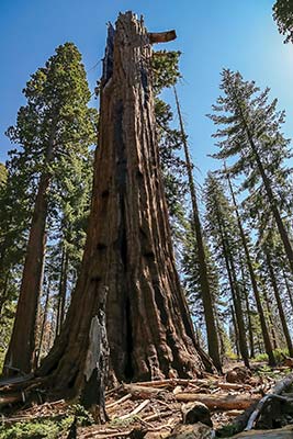
remains of the Washington Tree, once the second largest tree in the world
There are also trees named for other remarkable humans who left their mark upon the world. Next to the President Tree is the Chief Sequoyah Tree, named after Sequoyah, a prominent member of the Cherokee Nation who is credited with inventing the written form of the Cherokee language.
The Clara Barton Tree, one of the few trees named for a woman, honors the humanitarian founder of the American Red Cross. The Susan B. Anthony Tree was named for the champion of women’s suffrage, who not only fought for women’s right to vote, but also the abolition of slavery and an egalitarian society. Visit this tree just past the Clara Barton Tree, on the way to Round Meadow.
When Colonel Charles Young, the first acting superintendent of Sequoia National Park and leader of the Buffalo Soldiers, was offered a namesake tree in the early 1900s, he suggested it honor his contemporary instead, Booker T. Washington. Washington was born into slavery, but eventually attended a university, then went on to help found Tuskegee University. He also served on the boards of Fisk and Howard Universities and was an adviser to several U.S. presidents. In 2003, 100 years after Colonel Young’s service to Sequoia National Park, a tree near the Booker T. Washington Tree was dedicated to him. Both the Booker T. Washington Tree and the Colonel Young Tree can be found near the Auto Log.
The turnoff for Crystal Cave is 2 miles (3 km) south from the Giant Forest Museum. From the Generals Highway, the road to Crystal Cave is a very curvy 7 miles (11 km) that takes 45 minutes to drive. Drive time could increase if there’s road construction. Vehicles longer than 22 feet (7 m) or with trailers are not allowed on this road.
From the parking lot, a 0.5-mile (0.8-km) path descends to the cave entrance, marked by a famous gate—a large metal spiderweb built in the 1940s to protect the cave from vandalism.
Be sure to account for the drive time and the time it takes to walk to the cave entrance, so that you don’t miss your tour departure time. Plan to arrive 15 minutes before your tour starts.
Lodgepole and Giant Forest are a hiker’s paradise. All of the trailheads are accessible by shuttle.
Distance: 4.2 miles (6.8 km) round-trip
Duration: 2 hours
Elevation Change: 500 feet (150 m)
Effort: Moderate
Trailhead: Muir Grove/Dorst Creek Campground
Directions: From Lodgepole Village, drive 8.2 miles (13 km) west and north on the Generals Highway toward Grant Grove. Turn left onto Dorst Creek Road and continue through the campground for 0.9 mile (1.5 km). From the group campsites, turn left and park in the hiking parking lot. Via the Lodgepole/Wuksachi shuttle (purple route 3), get off at the third campground shuttle stop, walk west to the trailhead parking lot, and turn north. Enter the group site area on the left and turn right to head toward site B. The trailhead is just across the road from site B.
A short trail with great views brings you to the rarely visited Muir Grove. This is a great mellow morning hike if you’re staying at Dorst Creek Campground. The light filtering through the giants makes this a one-of-a-kind sequoia experience, especially in fall when the azaleas and dogwoods deliver colorful accompaniment to the sequoias’ red bark.
From the trailhead, follow a small dirt path north for a short distance. Do not cross the bridge, which will have you continuing on the Dorst-Lost Grove Trail. Instead, turn left onto Muir Grove Trail and head west. Stay on the south side of the creek as you follow it downhill among the firs and ferns. As the forest opens up, you will see Big Baldy rising above. As you ascend to a ridgeline, the visible crowns of sequoias draw closer. Continue along the granite ridgeline until the trail crosses a small creek. Here you’ll enter a section of burned sequoias, then you’ll find yourself surrounded by the sequoias of Muir Grove. Return the way you came to get back to the trailhead.
Dorst Creek Road, the road to the campground, is open June through September. If you’re here outside that period, you can get to the trailhead by hiking along the road, which adds another 1.8 miles (3 km) to the total distance of this hike.
Distance: 3.5 miles (5.5 km) round-trip
Duration: 2 hours
Elevation Change: 750 feet (230 m)
Effort: Moderate
Trailhead: Little Baldy
Directions: From the Lodgepole Village, drive 6.6 miles (11 km) west and north on the Generals Highway. At the top of a hill is a turnout signed for Little Baldy where you can park. The trailhead is on the eastern side of the turnout.
The views on this hike are unparalleled, offering memorable sunrises, stargazing, and everything in between. In the spring, there is snow on the peaks to the east; this is also usually when the air is clearest. In fall, you’ll have Little Baldy to yourself. Go in the mornings for clearer air, before the haze rolls up the mountain.
This out-and-back trail is easy to follow. Start on the first few stone steps and climb, following the sweet smells of Jeffrey pines in the sunshine. There are just two long switchbacks on this hike; you’ll climb parallel to a steep hillside and come around the back of Little Baldy, the granite dome perched well above the forest. The last 0.25 mile (0.4 km) is flat. Look for Mineral King Valley to the southeast. Nowhere else in the front country will you have such expansive views. Return the way you came.
The glacier-hewn granite canyons of Lodgepole are ideal for hikers looking to access the high country with relatively little effort.
Distance: 3.1 miles (5 km) one-way
Duration: 1.5 hours
Elevation Change: 480 feet (150 m)
Effort: Easy
Trailhead: Wuksachi Lodge upper parking area
Directions: From Lodgepole Village, turn right and head northwest on the Generals Highway for 1.6 miles (2.5 km). Turn right onto Wuksachi Way and follow this for 0.6 mile (1 km) to the lodge.
Named for the Wuksachi people who once inhabited the area, this easy dirt trail offers a pleasant walk through the forest well above the road, but with little elevation gain. Few people walk this trail, so you’re nearly guaranteed solitude. The pines and riparian areas along each creek are not only visually stunning, they also offer amazing smells and sounds—especially in early summer when hermit thrushes can be heard harmonizing.
From the end of the road by the Wuksachi Lodge, start your hike on the Wuksachi Trail. Trek along a few short switchbacks to cross Clover Creek. The trail slides around the nose of a hillside and leads you to Silliman Creek and other streambeds (which may be dry). At the junction with Twin Lakes Trail, turn right and head south on the Twin Lakes Trail. Continue your hike on the rock-lined path, which parallels the Marble Fork of the Kaweah River, until you reach Lodgepole Campground. You can return the way you came or, if it’s summer, hop on a shuttle from Lodgepole Campground to return to the Wuksachi Lodge.
Distance: 3.4 miles (5.5 km) round-trip
Duration: 2 hours
Elevation Change: 500 feet (150 m)
Effort: Easy
Trailhead: Tokopah Falls/Lodgepole Campground
Directions: From Lodgepole Visitor Center, drive east on Lodgepole Road for 0.5 mile (0.8 km). Veer left to enter the campground.
A trip to the elegant Tokopah Falls is always memorable: towering monoliths, beautiful granite slabs and scree fields, and the wildflower-lined Marble Fork of the Kaweah River.
The path to Tokopah Falls starts from the end of Lodgepole Campground’s upper loop, on the north side of the river. It’s a straight shot and a steady grade through the sunny forest on a sandy path. The best part is the last 0.25 mile (0.4 km)—a tumble of pure white boulders where pika and marmot can be heard chirping. At the end of the trail, gaze upon the calming cascade of Tokopah Falls, whose water streams down in several strands and jumps over cracks in the granite. Stay on the trail as the rocks are slippery. Return the way you came.
Distance: 11.5-12 miles (18.5-19 km) round-trip
Duration: 5-7 hours
Elevation Change: 2,300 feet (700 m)
Effort: Strenuous
Trailhead: Lakes/Wolverton
Directions: From Lodgepole Village, turn left onto the Generals Highway, heading southwest, and drive 1.5 miles (2.5 km). Turn left onto Wolverton Road and continue to the end of the road, another 1.5 miles (2.5 km). The Lakes Trail is the main trailhead among a distraction of signs. The Wolverton shuttle (orange route 4) stops here.
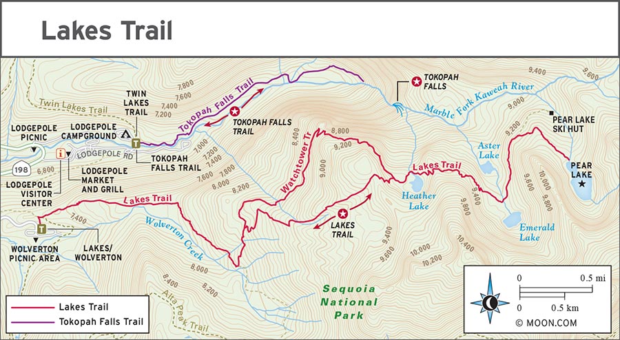
This out-and-back trek offers a plethora of lakes. This is a very popular trail with plenty of wildflowers and scenery for all. A series of lakes is evidence of a valley glacier that repeatedly traveled this trail eons ago. The glacier carved a u-shape valley, pausing intermittently before continuing its erosive steps down. Some of the lakes you’ll see along this trail include Heather Lake, named for the favorite flower of John Muir that grows on its shores; Aster Lake, which appears to have just emerged from the cracks in the rock; and Emerald Lake, which is secluded but easy to reach.
There are two options for hiking part of this trail. About 2 miles (3 km) in, you’ll choose between the Watchtower route and the Hump route. The Watchtower route includes a steep overlook and is a bit more gradual. The Marble Fork of the Kaweah River rips and turns through the canyon 2,000 feet (610 m) below. The Hump route is the only option for winter travel. It’s better for hikers who don’t like heights or exposure, but it’s a steeper trail. In total, the Hump Route is shorter by 0.5 mile (0.8 km), but has more elevation gain.
From the Lakes trailhead, follow the wide, well-traveled dirt path eastward for the first couple miles. At the north end of Britten Meadow, at the junction with Panther Gap Trail, turn sharply left (north) to stay on the Lakes Trail. After 0.25 mile (0.4 km), the trail will fork for the Watchtower or the Hump. They diverge for about 1.5 miles (2.5 km) before rejoining just above Heather Lake. Here, the peaks of the Great Western Divide and Silliman Crest perch above the canyon.
Continue directly up the rocky and sandy trail. Eventually, the trail passes between Aster and Emerald Lakes. Pass a junction for the ranger station (open in winter to skiers) and continue to Pear Lake. Once you’ve had your fill of this glacier-carved lake, go back the way you came.
Distance: 13.8 miles (22 km) round-trip
Duration: 8-9 hours
Elevation Change: 4,000 feet (1,220 m)
Effort: Strenuous
Trailhead: Lakes/Wolverton
Directions: From Lodgepole Village, turn left onto the Generals Highway, heading southwest, and drive 1.5 miles (2.5 km). Turn left onto Wolverton Road and continue to the end of the road, another 1.5 miles (2.5 km). The Lakes Trail is the main trailhead among a distraction of signs. You can also take the Wolverton shuttle (orange route 4) to this trailhead.
This trail offers incredible views. Nowhere else in the front country can you get such vistas within a day’s walk. Spending the whole day ascending this mountain, at 11,204 feet (3,410 m) above sea level, will definitely have you huffing and puffing, but the trail meanders among some of the most scenic parts of Lodgepole. This trail is awesome from spring, when the snows have melted out, through the first big storm, usually in October.
From the north end of the parking lot, take the Lakes Trail for the first 1.8 miles (3 km). Stay to the right to join the Alta Trail, which meanders and climbs through the Giant Forest. Continue along the Alta Trail, passing Panther Peak to the south. The trail takes you to Mehrten Meadow, with wildflowers and a small cascade. Take a break here if you need to.
Continue on Alta Trail for another easy mile until you reach the tough, steep climb to the peak. At the junction with Alta Meadow Trail, stay left to continue on Alta Trail to the peak. Along the way, try and spot rare foxtail pines, which are only found in California. When you reach the peak, take in the gorgeous views. The glaciated ridges along the Great Western Divide show the path of ice rivers, steeply descending over thousands of years. When you’re ready, head back down and return the way you came.
There are almost 40 miles (64 km) of trail within the Giant Forest and each one is unique. Climb a granite dome for spectacular views at Moro Rock or visit Crescent, Circle or Round Meadows for wildflowers. The trails described here are ordered from north to south on the Generals Highway.

Distance: 1-mile (1.5-km) loop
Duration: 30 minutes
Elevation Change: Negligible
Effort: Easy
Trailhead: Big Trees
Directions: Park in the lot for the Giant Forest Museum or take the Giant Forest shuttle (green route 1). There’s a paved, accessible path that leads to the trailhead from the museum. Visitors with disability placards can park at the small lot at the Big Trees trailhead.
This easy, fully accessible, paved trail encircles Round Meadow and is surrounded by sequoias. Rangers lead hikes on this popular trail daily, but you can learn on your own thanks to interpretive signs. There are several unique trees—a pair that has grown together named Ed by Ned, which start the hike, and several fire scarred trees, including one you can walk through. It doesn’t matter which direction you take the loop.
Despite its popularity, Round Meadow often boasts wildlife sightings: chickaree squirrels, Steller’s jays, garter snakes, and bears can be spotted across the meadow and along the hillsides. Giant wildflowers like corn lily, ranger’s buttons, and cow parsnip grow over three feet in height and fill the meadow, blooming through September. Sunrise and sunset here are especially nice, but Round Meadow is a treasure no matter the time of day.
Distance: 2 miles (3 km) round-trip
Duration: 1 hour
Elevation Change: Less than 500 feet (150 m)
Effort: Easy
Trailhead: General Sherman Tree
Directions: From Lodgepole Village, turn left onto the Generals Highway and drive southwest for 1.5 miles (2.5 km). Turn left onto Wolverton Road. After 0.6 miles (1 km), turn right. Follow this road for 0.7 miles (1.1 km) to reach the General Sherman Tree parking lot.
This paved loop hike takes you from the great General Sherman Tree to several other impressive sequoias nearby. From the parking lot, walk south on the paved trail to reach the General Sherman Tree. Near General Sherman, at the Leaning Tree (marked with a kiosk and bench), turn left onto the Congress Trail; you’ll be hiking this loop clockwise.
When the trail forks, take a right over a small bridge. This 0.8-mile (1.2-km) section of trail is crowded, but there are several amazing trees along the way. When the Congress Trail dead-ends into the Alta Trail, take a sharp right and, 100 yards later, at a small meadow, take a left on a spur trail. Admire the tremendous President Tree, which is the third largest sequoia in the world—topped only by General Grant and General Sherman. Nearby is the Chief Sequoyah Tree, a short walk off trail. Retrace your steps and get back on the paved trail, toward the Senate Group, an unmistakable cluster of sequoias, then continue your walk, following signs for Congress Trail heading northwest.
As you return north toward the parking lot, the trail brings you to the massive McKinley Tree, named for President William McKinley. Continue along this leg of the Congress Trail until you reach the General Sherman Tree once more.
Distance: 6.3 miles (10 km) one-way
Duration: 3 hours
Elevation Change: 500 feet (150 m)
Effort: Moderate
Trailhead: General Sherman Tree
Directions: From Lodgepole Village, turn left onto the Generals Highway and drive southwest for 1.5 miles (2.5 km). Turn left onto Wolverton Road. After 0.6 miles (1 km), turn right. Follow this road for 0.7 miles (1.1 km) to reach the General Sherman Tree parking lot.
This hike is a way to get off the beaten path and experience the bliss of seemingly endless meadows, carpets of indigo lupine, and some of the most wonderful giant sequoias that the park has to offer. Wildlife like pine marten and black bears are also more likely in these parts of the sunny forest. You’ll venture along seven different trails on this hike.
From the parking lot, go south on the paved trail. Turn left to join the Congress Trail and follow it to Alta Trail. Turn right and follow Alta Trail for 100 yards. At a small meadow, turn left onto a spur trail to reach the President Tree, and, just off the trail, the Chief Sequoyah Tree.
From the President Tree, follow the path to the Senate Group, a stand of six giant sequoias. On the south side of the Senate Group, follow the unnamed trail. The forest floor here is blanketed by green and purple lupine. Innumerable giant sequoias offer shade. Enjoy this ethereal section of the trail as you head south for 1 mile (1.5 km).
Continue slightly uphill and into the Circle Meadow Basin. You’ll enter the meadow by curving around its easternmost edge. The trail wraps around some fallen giants. Admire the meadow’s many flowers and grasses. At the edges, get a fleeting whiff of the Sierra rein orchid—30 tiny blossoms line a 16-inch-tall stem; each flower is hardly bigger than the mosquitoes and moths that pollinate them.
Cross the bridge at the southern end of the meadow to pass a couple of cool trees: Black Arch, a living tree you can walk through, and Pillars of Hercules. Past the trees, you’ll arrive at the Cattle Cabin, a one-room structure built a century ago. People lived here until 1916 when the cabin was purchased by the National Park Service. From Cattle Cabin northward, you are reentering a busier part of the forest, but you will still have plenty to enjoy.
Visit the beautifully symmetrical McKinley Tree before backtracking to take the trail to the west along a recently burned area and to the Lincoln Tree, the fourth largest tree alive today.
Next, take the Alta Trail southwest along a ridge. There is a left turn to a dirt path turnoff that leads to the Washington Tree. Once the world’s second largest tree, lighting struck this massive being in 2003, burning the inside and blasting limbs and bark some 30 feet outward.
From the Washington Tree, return north, retracing your path to get back to the Alta Trail. Continue southwest into a glen of dogwoods. As you cross Little Deer Creek along the Alta Trail, you’ll travel downhill to the Hazelwood Nature Trail, where yet another small meadow boasts bright yellow flowers. Turn left to reach the closest shuttle stop at the Giant Forest Museum and the Sentinel Tree. Hop on the shuttle to get back to your car at the General Sherman Tree parking lot.
Distance: 2.2 miles (3.5 km) round-trip
Duration: 1 hour
Elevation Change: Less than 500 feet (150 m)
Trailhead: Crescent Meadow
Directions: From the Giant Forest Museum, take the shuttle or drive the road to Moro Rock (Crescent Meadow Rd.) to the end, where there’s a parking lot. The trailhead is at the east end of the parking lot.
Most tourists come to this part of Sequoia to hike Moro Rock or go through Tunnel Log. But at the end of the road to Moro Rock is a network of trails surrounding Crescent and Log Meadows, strung together by Crescent Creek. This loop trail takes you to the top sights, including sequoia couples and triplets, as well as burnt, dead, and hollowed-out varieties. You can tack on other trails here if you have time and energy to spare for some rolling hills; most of the trails lead back to the parking lot. The signage can be confusing, so pick up a detailed map at the Giant Forest Museum. Deer and black bear are not uncommon in this part of the Giant Forest.
From the trailhead, follow signs for Crescent Meadow/High Sierra Trail heading east. The trail immediately crosses a little creek. When the High Sierra Trail veers right, stay to the left on Crescent Meadow Trail, which hugs the south end of Crescent Meadow. In just 0.2 mile (0.3 km), you will be taking the next right onto Log Meadow Trail, after the creek.
After a short uphill hike, you’ll overlook Log Meadow to the east, named for the extraordinary number of logs within. As you descend to meadow level, you will reach Dead Giant. Get up close and personal with the sheer magnitude of this recently fallen sequoia. (Note: This portion of the hike is rolling, but the trail flattens out as you cross two small and flower-filled creek beds.)
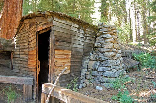
Continue along the trail to reach Tharp’s Log. This fallen sequoia once housed a man named Hale Tharp. He was one of the first non-Native American people to visit Giant Forest, led by two Yokuts guides in 1858. He lived in this hollowed-out tree each summer from 1861-1890, raising cattle in the meadow. His fireplace, kitchen, and living quarters remain well-preserved in the dark log. (You’ll need to use the flash if you’d like a photograph.)
From Tharp’s Log, a paved path leads south and west back to Crescent Meadow and the parking lot.
Lodgepole’s easy-to-follow trails are ideal for backpacking novices—they lead to unique scenery with moderate elevation gain, there are relatively few creepy crawlies or scary animals, and the night skies are spectacular.
This strenuous 13.6-mile (22-km) out-and-back trek can be an ambitious day hike, but it’s best done as a backpacking trip, which will allow you to relax and delight in the shores of the Twin Lakes. The Twin Lakes Trail follows water for almost the whole way and arrives at two lakes, which are more like fraternal twins than identical. A stunning meadow and views of the massive peaks of the Kings-Kaweah Divide, all over 10,000 feet (3,000 m), including Mount Silliman at 11,188 feet (3,410 m), are your rewards for the steep climb. This trip will appeal to fishers, swimmers, and wildflower lovers alike.
At the designated campsites at Twin Lakes, you’ll find fire rings, bear lockers, and a pit toilet. The best sites are on the shores of the larger lake, overlooking the talus slope and sheltered by trees. There are also passable campsites at Cahoon Meadow and the JO Pass junction, if you want to stop earlier. Even though this trail doesn’t always hit capacity, you’ll want to book your wilderness permit early.
Starting from Lodgepole Campground, follow the bridge across the Marble Fork of the Kaweah to the Tokopah Falls Trail. Almost immediately, take a left at the Twin Lakes trailhead. Walk along the trail through the forest into Tokopah Valley, where the path starts climbing.
After about a mile, the trail levels out and the forest closes in, changing to shade-loving firs. Follow the trail over windy Silliman Creek; you’ll cross twice in this section of trail. Continue to Cahoon Creek and Cahoon Meadow. These creek beds and meadows burst with wildflowers, attracting local birds.
Continue along the trail, steadily climbing up to Cahoon Gap, nearly 8,700 feet (2,650 m) in elevation. From Cahoon Gap, descend toward the junction that leads to JO Pass, where you will find a few campsites.
Stay right at the junction to continue east on Twin Lakes Trail, climbing along the trail until you arrive at Twin Lakes, signaled by an informational sign. The southern lake is larger and more exposed with reflections of Twin Peaks to the north. The northern lake is smaller and more forested.
Because of the scenery, accessibility, and relative ease, this 11.5-mile (18.5-km) trip on the High Sierra Trail to Bearpaw High Sierra Camp is extremely popular. Staying at Bearpaw is a backpacker’s dream: You don’t need to pack meals or bedding, because the camp provides all that for you. If you’re new to backpacking, or just looking to hike with a light pack, this trip is a great option.
High Sierra Trail
You’ll want to snag your Bearpaw reservation the day that they are made available for your desired date—366 days in advance. It costs around $200 per person per night (includes all meals), and spots go quickly. Reserve online (www.visitsequoia.com) or via phone (877/436-9726). Meals at Bearpaw are served up family style, with a vegetarian option at every meal. Beer and wine are available for purchase.
Wilderness permits are also required, but they’re free for confirmed Bearpaw guests. If you have a reservation at Bearpaw, you don’t need to reserve your wilderness permit in advance. Pick up your permit the day your hike begins at the Lodgepole Visitor Center’s wilderness desk (559/565-3766, 7am-11am and noon-3:30pm daily).
The High Sierra Trail is a gentle ribbon of rock, spanning from the sequoias to Mount Whitney, the highest peak in the continental United States. If you love the High Sierra but your knees or lungs can’t take the steepness of Cedar Grove or Twin Lakes, this is the hike for you. Starting at 6,800 feet (2,070 m) elevation, this hike ends just 1,000 feet (300 m) higher. If this is your first backpacking trip, the high mileage makes it a strenuous effort; it’s closer to moderate for those with more experience. The last mile is a real butt-kicker, going up several steep switchbacks. But, oh, the reward: vistas in every direction. Along the way you will pass several meadows and water features.
The trail begins at the Crescent Meadow picnic area, cutting east from the restrooms. After 0.5 mile (0.8 km), the trail departs Crescent Meadow and the sequoias. About 1 mile (1.5 km) in, after meandering through the eastern edge of the Giant Forest, you will reach Eagle’s View, an overlook where you can see into a 7,000-foot-deep (2,130-m) canyon—it’s deeper than the Grand Canyon.
Continue along the trail and you’ll reach Mehrten Creek, where a natural waterslide cascades over granite that’s speckled with wildflowers. Walk farther along the trail and you’ll reach the Buck Creek Bridge. From here, you have a strenuous 600-foot (180-m) climb over a mile of switchbacks before reaching Bearpaw High Sierra Camp. Just south of the camp is Bearpaw Meadow. If you were to venture some 60 miles (97 km) farther on the High Sierra Trail, you would reach Mount Whitney—the highest point in the Lower 48.
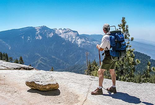
Positioned at the eastern edge of the Sierra Nevada, Mount Whitney is the highest point in the continental United States, at an elevation of 14,505 feet (4,420 m) above sea level. Thousands of people hike to the top each summer.
hiking Mount Whitney
There are several options for approaching this glorious mountain. The most popular option is to start from the town of Lone Pine and do the 22-mile (35-km) hike in one day, starting and leaving from the trailhead at Whitney Portal, just west of Lone Pine. This same trip can also be done as an overnight backpacking trip.
Plan for at least three days for your Whitney trip: one day for your arrival and getting your permit, one day for the hike, and one day (or more) for the recovery and return home.
If you can, budget extra time in the Sierra for acclimating to the high elevation. Know the symptoms of altitude sickness: headache, nausea, and feeling loopy, lightheaded, or tired.
Start training early. Do practice hikes of at least 16 miles and with 5,000 feet (1,520 m) or more elevation change. Practice using your trekking poles in preparation for the long, steep downhill return.
Here are some helpful items to pack that you might not normally carry on a day hike:
• headlamp and extra batteries for the pre-dawn start
• ibuprofen or Tylenol to help with minor symptoms of altitude sickness
• water filter or sterilization system to keep your pack weight down
• salty snacks, electrolyte powder or tablets
Wilderness permits (www.recreation.gov, $6 per permit, $15 recreation fee per person) are required year-round for day trips in the Mount Whitney Zone and overnight trips in wilderness areas. Permits are issued via a lottery system on Recreation.gov in early March.
To enter the permit lottery, have the following information on hand: method of travel, planned route, and the names of the primary and alternate trip planners. Permits must be picked up by noon the day before your scheduled departure.
The route from Whitney Portal is 22 miles (35 km), with over 5,000 feet (1,520 m) of elevation gain. Start by 5am to avoid afternoon thunderstorms at the summit. The major sights and stops along the trail include Lone Pine Lake, Outpost Camp, Mirror Lake, and Trail Camp. Just before you reach the summit is the Smithsonian Hut, a stone cabin that was constructed in 1909. Be sure to sign the log inside to prove you made it. Continue a bit farther and you’ve made it to the top of Mount Whitney. Take in the panoramic views for as long as you can.
Head back the way you came for 11 miles (18 km) to reach the trailhead at Whitney Portal. Be sure to take extra care on the descent, when exhaustion can take a toll on your knees and your balance.
To get to the trailhead at Crescent Meadow from the Lodgepole Visitor Center, drive south on the Generals Highway for 4.3 miles (7 km). Turn left onto Crescent Meadow Road (immediately after the Giant Forest Museum) and continue 2.6 miles (4.2 km) to its eastern terminus. On summer weekends, Crescent Meadow Road is closed. You’ll need to leave your car in the parking lot of the Giant Forest Museum and take the Moro Rock shuttle (gray route 2) to Crescent Meadow.
There is a designated snowplay area at Wolverton Picnic Area (eastern end of Wolverton Rd.). This open grassland area has two hills with few trees and sits at 7,250 feet (2,210 m) elevation, prime for the perfect amount of snow. Bring your sled, toboggan, and winter gear and head out on plowed Wolverton Road, located between Giant Forest and Lodgepole.
No winter trip to Sequoia is complete without a snowy trek through the Giant Forest. Many trail options are detailed in the cross-country skiing pamphlet available at the Giant Forest Museum.
Beginners should opt for a shorter hike with less elevation gain, like Crescent Meadow Road. Seasoned and advanced skiers will be delighted by challenging climbs into the wilderness, and might want to spend a day on the Alta Trail or a night at the Pear Lake Ski Hut.
You can rent snowshoes from Wuksachi Lodge or Lodgepole Market. Rangers lead free two-hour guided snowshoe walks. The walks occur on weekends and holidays, weather permitting. Call the Giant Forest Museum (559/565-4480) for departure times and to reserve a spot. Snowshoes are provided for free for these walks.
From the Giant Forest Museum, follow the wide, relatively flat Crescent Meadow Road for an easy snowshoeing trip. The road is not marked with blazes, but is easily followed due to its width. It is 2.5 miles (4 km) from Giant Forest Museum to Crescent Meadow, where the road ends.
When you’re ready to head back, return the way you came. After about 1.4 miles (2.3 km), you can depart Crescent Meadow Road to take the route to Bear Hill, which will add 1 mile (1.5 km) to the trip. Turn right onto Bear Hill Trail and follow the trail blaze, a yellow triangle with a bear on it. After you’ve climbed Bear Hill, turn left onto the Alta Trail and return to the museum.
This 1.2-mile (2-km) out-and-back trek along Old Lodgepole Road (also signed as the Congress Trail) passes by some of the largest living trees on earth. Start from the wheelchair-accessible parking lot for the General Sherman Tree, on the Generals Highway. (It’s open to all in the winter.) From the parking lot, join the path (usually cleared of snow) and head north on the General Sherman Tree trail. Keep left at each T intersection and you will arrive at the General Sherman Tree after 0.2 mile (0.3 km). Unlike in summer, you may have a chance of solitude with the world’s largest living tree. Consider the awe-inspiring fact that this tree has survived over 2,000 winters.
When you’re ready, return the way you came until you meet up with the yellow triangle signs marked with an L, indicating the old Lodgepole Road, or signs for the Congress Trail. About 100 yards from the parking lot, take the fork to the left, heading south. This is a good time to put on your snowshoes.
Continue south along the old Lodgepole Road and admire some of the largest trees in all of California’s groves, including the McKinley and Lincoln Trees, which are close to each other. Turn around at the Lincoln Tree to return to the parking lot.
Starting from Wuksachi Lodge, this moderate out-and-back trek (3.8 mi/6 km round-trip) to two creeks will have you feeling lucky to be here. Wuksachi Trail, marked by a four-leafed clover blaze, is for intermediate skiers and snowshoers.
From the lodge’s upper parking lot, the trail heads northeast. Trek along a few switchbacks before coming to the Clover Creek Bridge. Continue through the red fir forest for 0.8 mile (1.3 km) until you come to Silliman Creek. The swift creek leads your eye up to the great, beautiful Mount Silliman. Both creek and mountain were named for the Yale University chemistry professor Benjamin Silliman, who trained the leader of the first California state geologic agency, William Brewer. Cross the creek and continue another 0.2 mile (0.3 km) to the Twin Lakes Trail junction. Turn around when you get to a sharp right turn. Admire the scenery and then return the way you came.
Lodgepole and Giant Forest are the heart of Sequoia summertime storytelling. There are more rangers and programs here than anywhere else in the park. To see what unique programs are happening during your visit, check the kiosk at either of the campgrounds or stop by the visitors center.
Many programs are offered at the same time daily, including ones about bears at Lodgepole Visitor Center, guided walks along the Big Trees Trail, and campfire programs at Lodgepole and Dorst Creek Campgrounds.
Rangers are positioned at the base of the General Sherman Tree and on top of Moro Rock, and can also be found wandering Giant Forest and cruising Tokopah Falls Trail. Or you can stop into the Giant Forest Museum or Lodgepole Visitor Center for help on finding the perfect hike for you, tips on how to find a pika or identify a flower, or descriptions of a bear’s amazing birth.
There are a couple of great programs that the Sequoia Parks Conservancy sponsors at Wuksachi Lodge. Each morning you can attend Coffee with a Ranger and get a free cup of joe while you chat about the park. On select evenings there are living history performances, which tell of the hardships and successes of early park denizens.
You may be familiar with musician Bob Marley’s tribute to the Buffalo Soldiers, who in the final verse are described as “trodding through San Juan in the arms of America.” What you may not know is that since the Civil War, African American troops have been crucial in defending the United States and its natural resources. The song’s reference to the Spanish American War in 1898, where brave African American troops and cavalry fought up the slope of San Juan Hill in Cuba, is only one component of their legacy: The Buffalo Soldiers were also some of the first guardians of Sequoia National Park.
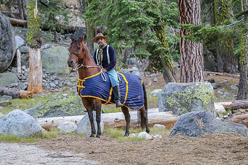
a Buffalo Soldier reenactor
The national park service was not established until 1916, but the big trees were so wonderful—and so imperiled—that they needed immediate protection. In 1903, six days after they escorted President Theodore Roosevelt around San Francisco, the Buffalo Soldiers were dispatched from the Presidio to Sequoia National Park. The M and I troops of the 24th Infantry and the 9th Cavalry journeyed over 300 miles (480 km) across California to reach Sequoia.
Under the direction of Captain Charles Young, one of the few African American officers in the segregated military, the troops established fire watches, surveyed a path to Mount Whitney, ran off loggers, prevented herders from letting their sheep graze the meadows, and protected other park resources. Young was born to parents who were enslaved and became the third African American graduate of the United State Military Academy. During his tenure as acting superintendent of Sequoia, he put his education in engineering to work by leading the construction of new roads and the maintenance of old ones.
When offered a named tree in his honor during this period, Young instead dedicated it to Booker T. Washington. A century later, in 2004, another tree was named in Young’s honor. Today, you can visit the Colonel Young Tree and the Booker T. Washington Tree on Crescent Meadow Road, which Young helped design.
Some of first defenders of Sequoia National Park were the Buffalo Soldiers—African American calvary and infantry units sent from the U.S. Army to protect the fledgling national park. Each year, Buffalo Soldier Day celebrates their legacy, as well as showcasing the group’s engineering feats in developing the road to the park. Events include guided walks at Giant Forest Museum, a special horse-led trip to the Colonel Young Tree, named for the first African American superintendent of a national park, and a living history reenactment of the daily life of the regiment. The event usually occurs in August; check the park website for the exact dates.
For any camping gear, food, clothes, maps, and books, visit the Lodgepole Market Center (63204 Lodgepole Rd., 559/565-3301, www.visitsequoia.com, 7am-9pm daily summer, winter hours are reduced). They have long hours, a nice selection of beverages and hiking snacks, along with almost anything you might need (and may have forgotten) for your stay in the campground, such as rain gear. The market also carries fresh and refrigerated foods.
Your best bet for cool books is the Lodgepole Visitor Center (63100 Lodgepole Rd., 559/565-4436, www.nps.gov/seki, 7am-5pm daily May-Nov.) or the Giant Forest Museum (Hwy. 198, 16 mi/26 km north of Ash Mountain entrance, 559/565-4480, www.nps.gov/seki, 9am-6pm daily May-Nov., 9am-4:30pm daily Dec.-Apr.). Both are run by the Sequoia Parks Conservancy which means every purchase helps support programs in the park. They have many publications that were created exclusively for the conservancy, on topics including Crystal Cave, sequoias, and John Muir. They also carry neat hats, shirts, mugs, water bottles, stuffed animals, and games.
Visit the lobby of the Wuksachi Lodge, where the small Wuksachi Gift Shop (64740 Wuksachi Way, no phone, 8am-9pm daily summer) carries local goods like honey, geological treasures, postcards, shirts, and jewelry. You can also find some interesting art to bring home so you will always remember your Sequoia adventure.
Lodgepole Café (63204 Lodgepole Rd., 559/565-3301, www.visitsequoia.com, 7am-9pm daily summer, winter hours are reduced), inside the Lodgepole Market Center, is a great option for on-the-go meals to take on the trails. In the morning, order grab-and-go breakfast sandwiches or burritos. In the afternoon, get made-to-order burgers or a chicken sandwich.
If you’re looking for table service, metal utensils, and views of 11,000-foot (3,350-m) peaks, then head to The Peaks (Wuksachi Dr., 559/625-7700 ext. 7608, www.visitsequoia.com, 7am-10am, 11:30am-3pm, and 5pm-10pm daily, lounge and bar with limited menu 2:30pm-5pm daily and full menu 5pm-9pm daily, $20-25). There are delicious options for everyone, including vegans, gluten-free folks, and kids. Enjoy some creative entrées, like mouthwatering burgers composed of short rib and brisket meat, as well as fresh salads, including a delightful shrimp and melon combination. The wine selection is basic (and expensive), but there are draft beers from local breweries for $8.50 per pint, as well as a full bar. It is highly recommended that you make a reservation for dinner (up to 30 days in advance). On Sunday mornings, the breakfast buffet has many options and a mimosa bar to boot. Whatever your order, a meal at the Peaks will be a memorable part of your vacation.
If you’re tired of roasting marshmallows at Dorst Creek Campground, enjoy some creature comforts in the form of fresh pizza at Stony Creek Lodge (65569 Generals Hwy., 559/565-3909 or 877/828-1440, www.mslodge.com/stonycreeklodge, 4pm-7:30pm daily May-Oct., $10-20), just 5 miles (8 km) north on the Generals Highway. The lodge’s restaurant offers a casual buffet dining option with pizza, wine, and beer on a simple patio.
The sister of Stony Creek Lodge, the Montecito Sequoia Lodge (63410 Generals Hwy., 559/565-3388, www.mslodge.com, 7:30am-9am, noon-1:30pm and 5:30pm-7pm daily summer, noon-1pm and 6pm-7:30pm daily off-season, breakfast $9, lunch $10, dinner $20-30) provides home-cooked, casual buffet dining perfectly positioned on a lake on the Generals Highway. In addition to the views, you can fill up on hot buffet choices, with two kinds of meat, special breads, and pastries. Vegetarian options are available daily. If you have allergies or other dietary restrictions, call ahead. Come at the beginning of the buffet hours for the best options.
One of the best ways to enjoy the scenery is sharing a snack with family and friends in the company of trees. Many of these picnic areas are temperate and available in the middle of the day, and hardly anyone stops by in the morning or evening. There may be fire restrictions in place, so check ahead if you want to grill.
Halstead Meadow Picnic Area is just the place to make a cup of coffee and wait for whatever may saunter into the peridot pasture. At 21 acres, the montane meadow is one of the park’s largest. Don’t miss the wildflowers in the summer. Halstead Meadow is 4 miles (6 km) west of the Lodgepole Visitor Center on the Generals Highway.
Away from the crowds, campground, and store, the Lodgepole Picnic Area gives visitors a taste of idyllic life, where you can swim in the Marble Fork of the Kaweah River and have dinner on a granite boulder. A loop parking lot, picnic tables, vault toilets, and water spigots mark this simple picnic area. You can walk down along the river until you reach the foothills; if you continue a bit farther, you’ll get your own private riverfront picnic spot. (Be careful walking along the river in springtime—the water is swifter, deeper, and colder than it appears and can be deadly if you fall in.) The picnic area is less than half a mile north of the Lodgepole Visitor Center, accessible from the Generals Highway.
Tucked away between Lodgepole and Giant Forest is a little valley and meadow with a quaint picnic spot overlooking the meadow at Wolverton Picnic Area. Barbecues and water are available. Heading south from Lodgepole Visitor Center on the Generals Highway, turn left onto Wolverton Road and continue to the end of the road.
After a hike in Giant Forest, replenish your energy by relaxing on a forested ridge. Pinewood Picnic Area features water, restrooms, and grills. Though not exactly a suppertime serenade, ravens and chickarees will add to the ambience, and the vanilla smell of Jeffrey pines will encourage dessert. Pinewood is near Round Meadow, on the north side of the road. Heading south on the Generals Highway from the General Sherman Tree, take the first right after about 1 mile (1.5 km).
Crescent Meadow Picnic Area does not have grills, but it has sequoias and sometimes deer and bears. After a hike through the Giant Forest, you can end your adventures with a picnic and take the shuttle back to your campground. The picnic area is at the eastern end of Crescent Meadow Road.
Though not an official picnic area, Beetle Rock has great views, access to restrooms by the Giant Forest Museum, and is near the museum’s parking lot. On a clear day, visibility extends to the bottom of the Central Valley, a mile below. On a hazy day, the sunset will be all the more vibrant. To access Beetle Rock, drive or take the shuttle to the Giant Forest Museum. In the parking lot across the street, walk to the right of the entrance. A short distance down a dirt path is a picnic table and an open rocky area, shaped like the domed back of a ladybug beetle.
view from Beetle Rock
If you didn’t already know about Wuksachi Lodge (64740 Wuksachi Way, 866/807-3598, www.visitsequoia.com, from $140 winter, from $260 summer), you would never realize that a highly rated and popular hotel is tucked away on the ridgetop forest. With 102 rooms, the lodge is an ideal home base for visitors with a loose definition of “roughing it.” It affords stunning vistas, luxe amenities, and the ability to meet other like-minded nature lovers. Located 2 miles (3 km) north of Lodgepole and 6 miles (10 km) north of Giant Forest, the lodge’s discrete log-cabin buildings are mostly hidden, except for the main lodge, which houses a full-service restaurant, cocktail lounge and bar, gift shop, conference center amenities, and a deck with a window-service food spot.
Guest rooms are set back in quiet nooks a couple hundred yards away from the lodge. Each room has a mini-fridge, television, and coffee maker. There are three room options: Standard rooms accommodate four people but do not have the sofa. Deluxe rooms have more space and can include a crib or rollaway bed for a maximum of five people, as well as a sofa or table and chairs. The Superior room can accommodate six people and has an alcove for seating or sleeping. There is Wi-Fi, but it’s best for social media and email access, not for streaming videos. Guests can order box lunches ($10-14) ahead of time to take on the trail the following day. The boxes include a sandwich (veggie or meat), chips, fruit, and a drink.
The lodge has services to help guests with luggage; there are no elevators. They also have rooms with mobility and hearing accessibility, including roll-in showers and visual alarms. Views are best from the Stewart Building. Pets are allowed for an additional fee of $25.
The lodge is open all year, but you might need chains to get here in the winter. Call and make your dinner reservation at the lodge’s on-site restaurant, The Peaks, up to 30 days before your stay.
For family fun, stay at the all-inclusive Montecito Sequoia Lodge (63410 Generals Hwy., 559/565-3388 or 800/227-9900, www.mslodge.com, from $180 winter, from $250 summer). Surrounded by beautiful views and on the edge of a lake, this secluded resort has been helping families unplug and enjoy the peace of the mountains since the 1970s. Instead of televisions, guests enjoy swimming and boating in the lake, horseback riding, tennis, beach volleyball, and archery. Book a room in the lodge or a standalone cabin. Some of the cabins have a separate, shared bath. The lodge has Wi-Fi, accessible from its restaurant. Rates include buffet meals, snacks, and drinks, activities, and kids’ programs.
The halfway point between Lodgepole and Grant Grove is Stony Creek Lodge (65569 Generals Hwy., Sequoia National Forest, 559/565-3909 or 877/828-1440, www.mslodge.com/stonycreeklodge, May-Oct., $170-230), the sister property of the Montecito Sequoia Lodge. This rustic 12-room hotel, seemingly hewn from the mountains around it, lies near the border of Sequoia National Park. Breakfast is included in the rate.
Within view of the granite mountains above, Lodgepole Campground (Apr.-Nov., $22) provides the closest access to excellent hiking and creature comforts. With all 203 sites within earshot of the Marble Fork of the Kaweah River, the campground provides rest and relaxation with a perfect soundtrack. Conveniently, several trails leave right from this area: Tokopah Falls, Twin Lakes, and Wuksachi Trail. It’s also walking distance to Lodgepole’s market, restaurant, laundry, showers, and shuttle. The campground has a dump station, flush toilets, and a pay phone. Be sure to store everything that smells in a bear locker and stay within arm’s distance of your food: Bears are very active in this area. For backpackers starting or ending trips, there are some walk-up sites available. Make a reservation early (starting in November of the previous year) because this campground is very popular.
Despite some tight quarters, uneven ground, disruptions by bears, early risers, and late night singers, Dorst Creek Campground (June-Sept., $22) is perfectly located for family or solo trips. Located 9 miles (14 km) from Lodgepole and 18 miles (29 km) from Grant Grove, the 212 sites of this midway point campground are often full because of its combination of landscape and amenities, which include flush toilets, water, fire pits, picnic tables, dump station, and a pay phone. Sometimes last-minute reservations can be found, and walk up sites are available on weekdays. The campground offers group sites for 15-50 people ($50-70) and wheelchair-accessible sites. It also provides access to Muir Grove and Dorst Creek Trails.
Two campgrounds on national forest land offer over 70 sites and access to Lodgepole and Giant Forest, Grant Grove, and Hume Lake, all within 20 miles (32 km). Perhaps because of their proximity to good mountain biking, Big Baldy, and Jennie Lakes Wilderness, as well as easy access to the amenities at Stony Creek Lodge, both campgrounds are popular. Located half a mile east of Stony Creek Lodge on the Generals Highway, both campgrounds are open from late May through late September or early October, depending on weather. You may need a permit for your campfire or stove, so check fire restrictions before you arrive. Stony Creek Campground (Sequoia National Forest, 877/444-6777, www.recreation.gov, late May-mid-Sept., $27, $7 for extra vehicle) has 50 sites with flush toilets and an amphitheater. Across the highway, a more rustic Upper Stony Creek Campground (Sequoia National Forest, 877/444-6777, www.recreation.gov, late May-mid-Sept., $18, $5 for extra vehicle) has vault toilets and 23 RV and tent sites.
Unlike in the national park, which only allows camping in the backcountry or in campgrounds, dispersed camping is an option in the national forest. If you plan to have a fire, pick up a free permit at the visitors center in Grant Grove, at Hume Lake Ranger Station, or online at www.fs.usda.gov/sequoia. You’ll need to bring your own water and manage your waste properly.
The Generals Highway cuts through steep mountainsides, which means that rockslides and other hazards are common. The park service is constantly working to keep it drivable for visitors—and safe for wildlife, too. Ongoing road-widening projects can cause delays of up to an hour.
You can attempt to avoid delays by planning to your trip around construction hours, especially between Hospital Rock and Beetle Rock, and between Grant Grove and Lodgepole. The parks’ entrance stations provide clear schedules so that you can plan accordingly. Another alternative is to make your accommodations in Lodgepole or at the Wuksachi Lodge, Stony Creek Lodge, or Montecito Sequoia Lodge, which are all within shuttle or walking distance of area attractions.
In the summer, the roads are more crowded with visitors. Get ready for bear jams—when people spontaneously stop or abandon their cars to snap a photo of a bear somewhere close to the road—and try to be patient. Fall and winter see fewer crowds, Crescent Meadow Road is fully open to vehicles, and visitors can park in the wheelchair-accessible lot for the General Sherman Tree (in the summer, this lot is open only to vehicles with disability placards). While some areas may be closed due to snow, plows work quickly to open up Wolverton Road.
There are several parking options in the area. Across the street from the Giant Forest Museum is a large lot for both RVs and personal vehicles. The main parking lot for the General Sherman Tree is off Wolverton Road. Lastly, just beyond the Lodgepole Market and just after entering the campground, there is a huge parking area that will provide access to the Tokopah Falls Trail. All of these areas are frequently serviced by shuttles, allowing you to park your car for the day while you explore the area.
The free shuttles in Sequoia offer convenient routes, spanning from Dorst Creek Campground and Wuksachi Lodge to the Giant Forest, Moro Rock, and Crescent Meadow. The longest trip is about an hour, but most stops are within 20 minutes of each other and can make one-way hikes more convenient. The shuttles run every day in the summer from 8am to 6pm. In the winter, shuttles run every 30 minutes on weekends only. For more information on the different routes, visit www.nps.gov/seki.
It’s best to fuel up before entering the park, in Three Rivers, Squaw Valley, or Dunlap. There is one gas station not too far from Lodgepole, if you’re running low. About 13 miles (21 km) north of the Lodgepole Visitor Center, Stony Creek Lodge (65569 Generals Hwy., 559/565-3909) has 24-hour credit card gas pumps in the summer. Electric cars can use the local plugs at Wuksachi Lodge, but they may not be suitable for your vehicle.