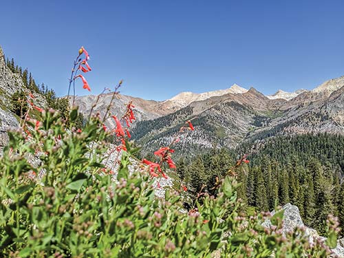
wildflowers in Mineral King
wildflowers in Mineral King
Look for S to find recommended sights, activities, dining, and lodging.
S Go Back in Time at Atwell Mill and Grove: This quiet glen that was once a working timber mill offers visitors a look at Mineral King’s mining history (click here).
S Stroll to Black Wolf Falls: Just minutes from the road, you will find a perfect cold, white waterfall set amid yellow wildflowers (click here).
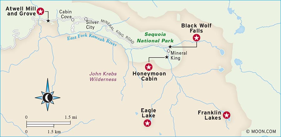
S Revisit the Past at Honeymoon Cabin: Stop by the remains of an early 1900s cabin and learn about the area’s surprising history (click here).
S Hike to Franklin Lakes: Pass cascades and plenty of wildflowers on this climb to a wonderous alpine scene (click here).
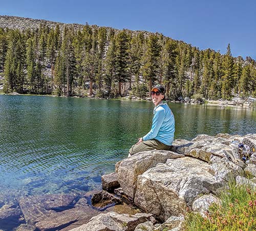
S Trek to Eagle Lake: The hike to this quintessential Sierra lake is an adventure that hikers of all ages will enjoy (click here).
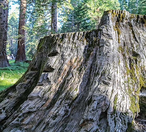
tree stump at Atwell Mill.
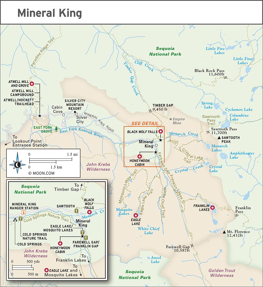
Named to the National Register of Historic Places, Mineral King preserves a storied past. The Yokuts people summered here for centuries before settlers discovered silver in the 1870s. Residents of the 3,000-person boomtown Beulah sought their fortunes in the mines. Avalanches and limited returns led to a bust and the end of the town. The area, which encompassed the former Beulah and is now known as Mineral King, was named for the variety of precious ore found in the rocks here. At one point, Disney planned a ski resort where the small Cold Springs Campground now stands, but was thwarted by a famous legal battle with the Sierra Club.
Though it’s rich with interesting history, the real prize for making the journey to Mineral King is the landscape. Stunning Black Wolf Falls and Crystal Falls can be seen throughout the valley. Sawtooth Peak glows pink at sunset, standing as a sentinel above the valley. Eagle Lake’s views and wildlife will transport you to nature’s version of a dream world.
Today, Mineral King’s untrammeled wilderness is one of the best places for visitors with more time and less tolerance for crowds. Those who brave the harrowing drive (about 1-2 hours from the Foothills region) to get here will be rewarded with stunning views from easier hiking trails in the high country. For rock hounds, there are alpine caves and beautiful banded marble among metamorphic folds of rock.
For your visit, pack your own food, fill up on supplies (especially gas), and watch out for marmots (they chew exposed wires on vehicles, searching for rare salts). Your time in Mineral King will be unlike any other in California: remote, wild, and peaceful.
Like most of the High Sierra, Mineral King is inaccessible during the long winter season. Roads open around Memorial Day and close at the end of October. Services like potable water are suspended even earlier in October. Spring, summer, and fall are busy as tourists come for wildflowers, animals, hiking, and fishing. Mineral King is home to some of the park’s coolest temperatures as well as the highest-elevation trailheads and campgrounds.
Mineral King is a high-elevation valley, nestled at 7,800 feet (2,380 m) elevation, and the weather can be temperamental. Cloudless skies and exposed trails can make for exhausting hiking conditions. Be prepared for afternoon thunderstorms and frigid nights. Snow can persist at some of the passes through June. Mineral King Road opens in May and closes in October. Early- and late-season visits can be chilly, with highs in the 40-60s (4-16°C) and lows in the 20-30s (-6 to -1°C). From June through September, the valley warms up. Temperatures can reach the 90s (32-37°C) during the day, but campers will enjoy a cool evening in the 40-50s (4-10°C).
Just south of Mineral King, sequoia groves like Atwell Mill sit about 1,000 feet (300 m) lower in elevation. The groves tend to be sunny and warm—over 70°F (21°C) during summer days. Campers at Atwell Mill Campground will also enjoy slightly warmer temperatures at night compared to Cold Springs Campground.
Three days in this part of the park will give you a chance to acclimate to the high elevation, try a hard hike, and enjoy dipping your toes in the creek before heading home. But you can hunker down for a full week to make the most of the picturesque landscape. If you’re just coming for a weekend, aim to arrive early on a Friday to ensure a campsite and head out by 2pm on Sunday for the safest driving conditions.
If Mineral King is your only stop in Sequoia and Kings Canyon, you can experience a sequoia grove at Atwell Mill or East Fork Grove. If you’re venturing into the backcountry, reserve a permit beginning March 1 in order to pick your favorite trailhead.
The Mineral King Ranger Station (mile 24/km 39, Mineral King Rd., 559/565-3768, 8am-3:45pm daily late May-mid Oct.) issues wilderness permits, rents bear cans, and sells water bottles and hiking maps, including detailed quadrangle topographic maps. You can also get your national park passport stamped at the station.
The vehicle entrance fee is $35 for Sequoia and Kings Canyon National Parks. The Lookout Point Entrance Station (Mineral King Rd. and Hwy. 198, 559/565-3341, late May-mid Oct.) does not have much in the way of services, but it is a good spot to stop and stretch your legs. Restrooms and some information about the park are available. RVs and trailers should turn around at this point.
This exciting drive along Mineral King Road spans from its western junction off Highway 198, to its eastern terminus, a distance of 25 miles (40 km). Budget about 1.5 hours to do this one-way drive. With a combination of pavement and gravel, this drive is not ideal for low-clearance vehicles. It’s also not for the faint of heart, featuring hairpin curves and exposed cliffs.
From the town of Three Rivers, the turnoff for Mineral King Road is 3.8 miles (6 km) northeast on Highway 198. The turnoff is hard to see; take the first right after the sign that reads “Sequoia Nat’l Park 2.” If you get to the Ash Mountain entrance, turn around and go back 2 miles (3 km) on Highway 198 to find Mineral King Road.
After 6.5 miles (10.5 km) on Mineral King Road, stop at a pullout before you cross the cement bridge, built in 1923 to allow passage over the East Fork of the Kaweah River. Peer into the canyon and admire the view. In spring, a waterfall is visible upstream.
Hop back in the car and continue along Mineral King Road, now running parallel to the East Fork of the Kaweah River. When you reach the Lookout Point Entrance Station, pull over and take in one last view of the foothills.
From here you’ll notice the composition of the forest changing from buckeyes to pines. Severe droughts in recent decades have changed the composition of southern Sierra conifer forests more drastically than in other areas. Continue your drive and climb through the forest. There are a couple roadside picnic areas that make nice stops along the way.
Nine miles (14 km) past the entrance station, Atwell Mill Campground marks the center of this giant forest. Pull off the road here and pause for a moment to take in the big trees before continuing uphill.
As you continue along the road, you’ll spot great Sawtooth Peak with its unmistakable profile above many other mountains. Next, you can stop at the Mineral King Ranger Station and stay for a program. At the end of the day, take in the peaceful sunset alongside a small creek near the Eagle Lake trailhead. You’ve reached the eastern end of Mineral King Road. To return, go back the way you came.
At the western edge of Atwell Mill Campground, there is an unnatural glen. Here you’ll find the unmarked Atwell Mill, a structure once used by the Kaweah Commonwealth Colony, a group of would-be utopians, after they were kicked out of Giant Forest. Unfortunately, lumber milling was impractical in the glen, so they resorted to logging the nearby sequoias. The remaining metal infrastructure and surrounding stumps you see here can help you imagine a much louder and busier time in Mineral King, when hundreds of people would have been milling timber. Today, you can see new sequoias are springing skyward.
To access the unmarked mill and meadow, follow the Atwell Mill Campground road to the end, near site 17. A dirt trail takes you downhill 50 yards to the old mill site. If you aren’t staying at the campground, you can park at the end of the road.
Throughout the valley, Black Wolf Falls is visible. It’s beautiful from a distance, but it’s even better up close. The water forms a stout, asymmetrical cascade that’s dense and frothy on its right side and a gentle, shimmering trickle on its left. Interrupting the flow are occasional rocky ledges where clusters of vibrant yellow mountain monkeyflower bloom. At the end of the season, when other waterfalls dry up, Black Wolf keeps running. The trail to the waterfall has no clear start, but a short walk brings you to the sight and sounds of water dancing on rock.
Near the end of Mineral King Road is a fork that diverges to the Franklin Lakes trailhead on one side and the Eagle Lake trailhead on the other. Park near the trailhead for Franklin Lakes. (On busy weekends, it can be hard to find a spot.) Walk back the way you came, about 150 yards (toward the ranger station).
On a straight stretch of the road that’s bordered by cottonwood trees, you come across a dry riverbed. Walk east for about 200 yards on any of the informal trails that depart from either side of the riverbed. There’s really no wrong way to approach the falls, as the informal trails all converge into one short dirt path along the hillside that brings you through the brush and to the misty waterfall. Stay and swim in the small pool beneath the waterfall or admire (but do not enter) the mining tunnel to the right of the falls. Return the way you came, keeping an eye out for warblers and chickadees.
Honeymoon Cabin (dawn-dusk daily late May-mid-Oct.) is a free, open-air museum maintained by the Mineral King Historical Society (http://mineralking.org). At the eastern end of Mineral King Road, near the parking area for the Eagle Lake trailhead, is this one-room cabin built around 1914. Photographs and artifacts offer a glimpse of life for the miners and their families who once lived in this area starting in the late 1800s. The displays are updated annually by the museum’s passionate curators.
It may be hard to believe, but the land that this cabin resides on is technically owned by the Walt Disney Company. A swath of what’s now Mineral King was purchased in the 1960s by Disney with the goal of developing a ski resort. The idea was eventually abandoned after preservationists like the Sierra Club stepped in.
Every hike in Mineral King has some elevation gain. The area is bookended by Timber Gap and Farewell Gap, and surrounded by Mineral, Sawtooth, Florence, and White Chief Peaks.
Distance: 3 miles (5 km) round-trip
Duration: 1.5 hours
Elevation Change: 600 feet (180 m)
Effort: Easy
Trailhead: Hockett, Atwell Mill Campground
Directions: From the Lookout Point Entrance Station, drive 9 miles (14 km) northeast along Mineral King Road to the Atwell Mill Campground. The trailhead is near site 16. Parking is available in the lot on the east side of the campground.
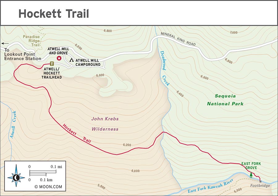
Named for John B. Hockett, who helped design Mineral King Road, the full length of the popular Hockett Trail is 10 miles (16 km). This 1.5-mile (2.5-km) section is an easy walk that dips into the canyon, reaching a small waterfall beneath big trees, and a little wooden bridge.
In Atwell Mill Campground, follow the dirt road heading southeast, passing a variety of trees, including some giant sequoias. At 1.5 miles (2.5 km) from the trailhead, you’ll reach a giant sequoia grove. Stop at the footbridge that crosses the East Fork of the Kaweah River and admire your surroundings. When you’re done, return the way you came.
Distance: 2.3 miles (3.7 km) round-trip
Duration: 1 hour
Elevation Change: 460 feet (140 m)
Effort: Easy
Trailhead: Cold Springs Campground
Directions: From the Lookout Point Entrance Station, drive 13 miles (21 km) northeast along Mineral King Road. Pass the road to Cold Springs Campground on the right and park near the Mineral King Ranger Station. You’ll need to walk from here into the campground to start the hike. The trailhead is near site 6.
This dirt path is accessible to most, with few stairs and many wildflowers as you meander upstream from Cold Springs Campground into the Mineral King Valley with Sawtooth Peak above and Black Wolf Falls below.
Follow the lightly traveled trail east from the campground, keeping an eye out for deer and marmot. Enjoy the interpretive signs, which help identify native plants and trees. At the end of the trail, you’ll find private cabins. They sit on the remains of Beulah, the mining town that thrived in Mineral King until the 1906 San Francisco earthquake. When you’re ready, return the way you came.
Distance: 9.8 miles (15.8 km) round-trip
Duration: 6 hours
Elevation Change: 1,400 feet (430 m)
Effort: Moderate-strenuous
Trailhead: Sawtooth
Directions: From the Lookout Point Entrance Station, drive 13 miles (21 km) northeast along Mineral King Road to the Mineral King Ranger Station. Continue 1 mile (1.5 km) farther east to reach the Sawtooth trailhead, on the north side of the road.
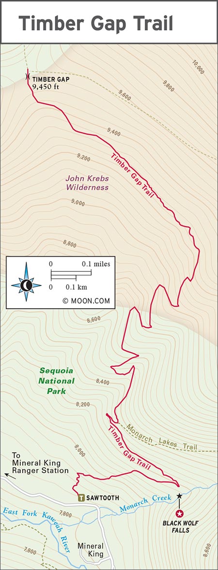
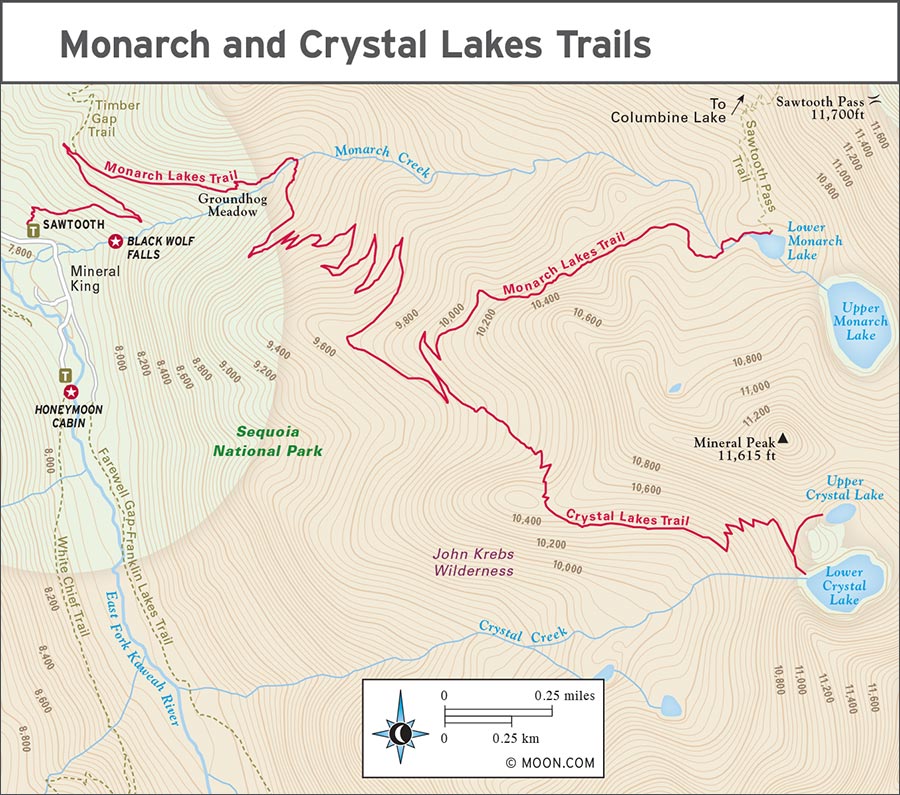
Start your hike from the Sawtooth trailhead, walking through sagebrush-lined switchbacks and stopping to view Black Wolf Falls along the way. Continue northward on this old mining route. At 0.2 mile (0.3 km), you’ll reach a fork with the Monarch Lakes Trail. Keep left to continue north on the trail to Timber Gap. As you continue to climb steadily through a mix of sun and shade, the views improve. Look to the south, all the way across the valley, and spot Farewell Gap as you trek along the switchbacks that cut through red fir forest.
At mile 4.9 (km 7.9), cresting a hill, you’ll reach Timber Gap, the pass between Mineral King and the Middle Fork of the Kaweah River Canyon. Stop and enjoy the shaded view. To the south, all of Mineral King is laid out before you, including the canyon that houses the East Fork of the Kaweah River. To the north, the top of a massive exposed plume of granite marks Alta Peak. When you’re finished catching your breath and taking in the views, return the way you came.
Adventurous hikers may want to traverse to the right from the top of Timber Gap, approximately 0.75 mile (1.2 km) along a historic wagon road to the ruins of the Empire Mine and its camp. Backpackers can link Timber Gap to Bearpaw Meadow.
Distance: 9 miles (14 km) round-trip
Duration: 6 hours
Elevation Change: 2,600 feet (790 m)
Effort: Moderate-strenuous
Trailhead: Sawtooth
Directions: From the Lookout Point Entrance Station, drive 13 miles (21 km) northeast along Mineral King Road to the Mineral King Ranger Station. Continue 1 mile (1.5 km) farther east to reach the Sawtooth trailhead, on the north side of the road.
This out-and-back trail is one of the easier ones in the valley, but it is still challenging because of its mileage and the elevation gains. Spend the night if you can: Stargazing up here will blow your mind. Crystal Lake is less crowded than Monarch, but Monarch offers access to the lovely and remote Columbine Lake via a backcountry trip over Sawtooth Pass. Whichever lake you choose, you’ll be glad you made the trek—these lakes are why people come to Mineral King.
From the Sawtooth trailhead, trek along sagebrush-lined switchbacks, pausing on a rusty rock that overlooks Black Wolf Falls. After 0.2 mile (0.3 km), the trail will split: Keep right to stay on Monarch Lakes Trail. Continue to Groundhog Meadow, named for the yellow-bellied marmots who sun themselves here. Deer are also common in this area.
After a quick pause at the meadow, continue climbing for 2.2 miles (3.5 km), darting back and forth across a hillside with little exposure along an even grade. You’ll come to a fork in the trail. To reach the Monarch Lakes, take the more traveled northern path (to the left). After 1 mile (1.5 km), you will reach the Lower Monarch Lake, cradled beneath Sawtooth Peak. Continue an additional 200 feet (60 m) south to Upper Monarch Lake to get a better feel of the place.
To reach the Crystal Lakes from the fork with the Monarch Lakes Trail, take the southern (right) trail. Hike for 1.7 miles (2.7 km) until you reach the base of Mineral Peak, formerly named Little Matterhorn, and home to three mines: Silver Tip, Buckeye, and Crystal. The trail is well worn, though not officially maintained, so loose rock makes it a challenging trek. Continue your ascent until you reach Lower Crystal Lake. Upper Crystal Lake is accessible via a northwest spur trail just before the Lower Crystal Lake dam.
From either the Monarch or Crystal Lakes, you’ll return the way you came to the Sawtooth trailhead.
Distance: 11.4 miles (18 km) round-trip
Duration: 8 hours
Elevation Change: 3,460 feet (1,050 m)
Effort: Strenuous
Trailhead: Franklin Lakes/Farewell Gap
Directions: From the Lookout Point Entrance Station, drive 14.3 miles (23 km) northeast along Mineral King Road, passing the Mineral King Ranger Station, to a fork in the road. The eastern fork is where you’ll find the trailhead for Franklin Lakes. You can park here, but don’t block the driveway to the stables. If there’s no room to park, go back and take the western fork across a bridge to a gravel parking lot (also the location of the Eagle Lake/Mosquito Lakes trailhead). Retrace your path across the bridge and to the eastern fork to start hiking. There’s a restroom between the two trailheads, next to the river.
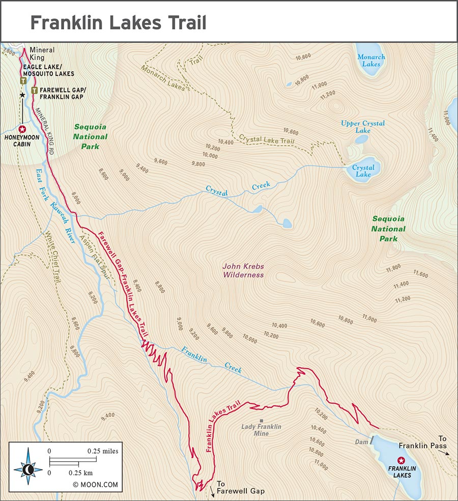
This exposed trail on the eastern side of the valley climbs gradually to the reward of the Franklin Lakes and Farewell Gap. Following the East Fork of the Kaweah River, you’ll meander among sagebrush, with plenty of wildlife like green tailed towhees to keep you company. There are great camping options here if you wish to backpack and stay the night by the lakes.
Heading south from the trailhead, you’ll pass the old corrals and Mineral King Pack Station. Continue straight for 1 mile (1.5 km), climbing 200 feet (60 m) in elevation, an ideal height for viewing a waterfall at Crystal Creek. At a small fork, keep left and take the uphill route. After 0.5 mile (0.8 km) you’ll encounter switchbacks beginning at Franklin Creek. At 3.7 miles (6 km) from the trailhead, a short set of switchbacks takes you on a path departing from the Farewell Gap Trail. At this fork, take the high road and stay to the left to reach the Franklin Lakes.
The Mather Mountain Men Party entered the valley via Timber Gap, visible for the last time as you cross the Lady Franklin Mine. These pioneers of protected public lands walked their stock up the slippery, snowy hillside. As you climb, consider that at least you’re not pulling a horse. When you reach the top, you’ll be rewarded with beautiful Lower and Upper Franklin Lakes.
Adventurous climbers may enjoy a scramble up the scree to Florence Peak or Rainbow Mountain. Return the way you came to get back to your car.
Distance: 7.1 miles (11.4 km) round-trip
Duration: 4 hours
Elevation Change: 1,500 feet (460 m)
Effort: Moderate
Trailhead: Eagle/Mosquito
Directions: From the Lookout Point Entrance Station, drive 14.3 miles (23 km) northeast along Mineral King Road, passing the Mineral King Ranger Station, to a fork in the road. Take the western fork and cross a bridge to reach a gravel parking lot. The Eagle Lake/Mosquito Lakes trailhead is accessible from the parking lot.
Though Mineral King wasn’t preserved until 1973, the man who became the first director of the National Park Service, Stephen T. Mather, thought it was worthy of preservation when he and a posse of conservation leaders toured Sequoia in the early 20th century.
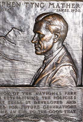
a plaque depicting Stephen T. Mather
On July 14, 1915, they left Visalia for Giant Forest and just three days later arrived by mule in Mineral King Valley. They entered from the north via Timber Gap, paused to admire Sawtooth Peak before spending a raucous night in the valley near what we now call Honeymoon Cabin. Mather’s tall tales of bears and mountain lions scared two of the party off, and the next day, only 17 of the influential men and their support team attempted to hike up the steep, grueling trail of granitic sand, climbing 4,000 feet (1,220 m) in 5 miles (8 km) to Franklin Lake. They opted out of leaving via Farewell Gap, selecting to walk their horses up to a snowy and icy Franklin Pass instead. Reaching the Great Western Divide, the party peered across the many granite peaks of the Sierra to their first sight of Mount Whitney.
This trip was more than a travel adventure. Gilbert Grosvenor, the first publisher of National Geographic magazine, dedicated an issue to the protection of what would become the national parks. This issue was placed on the desk of every member of Congress. Mather and his mountain party’s journey, in part, led to the passage of the Organic Act, establishing the national park service and preserving the park lands.
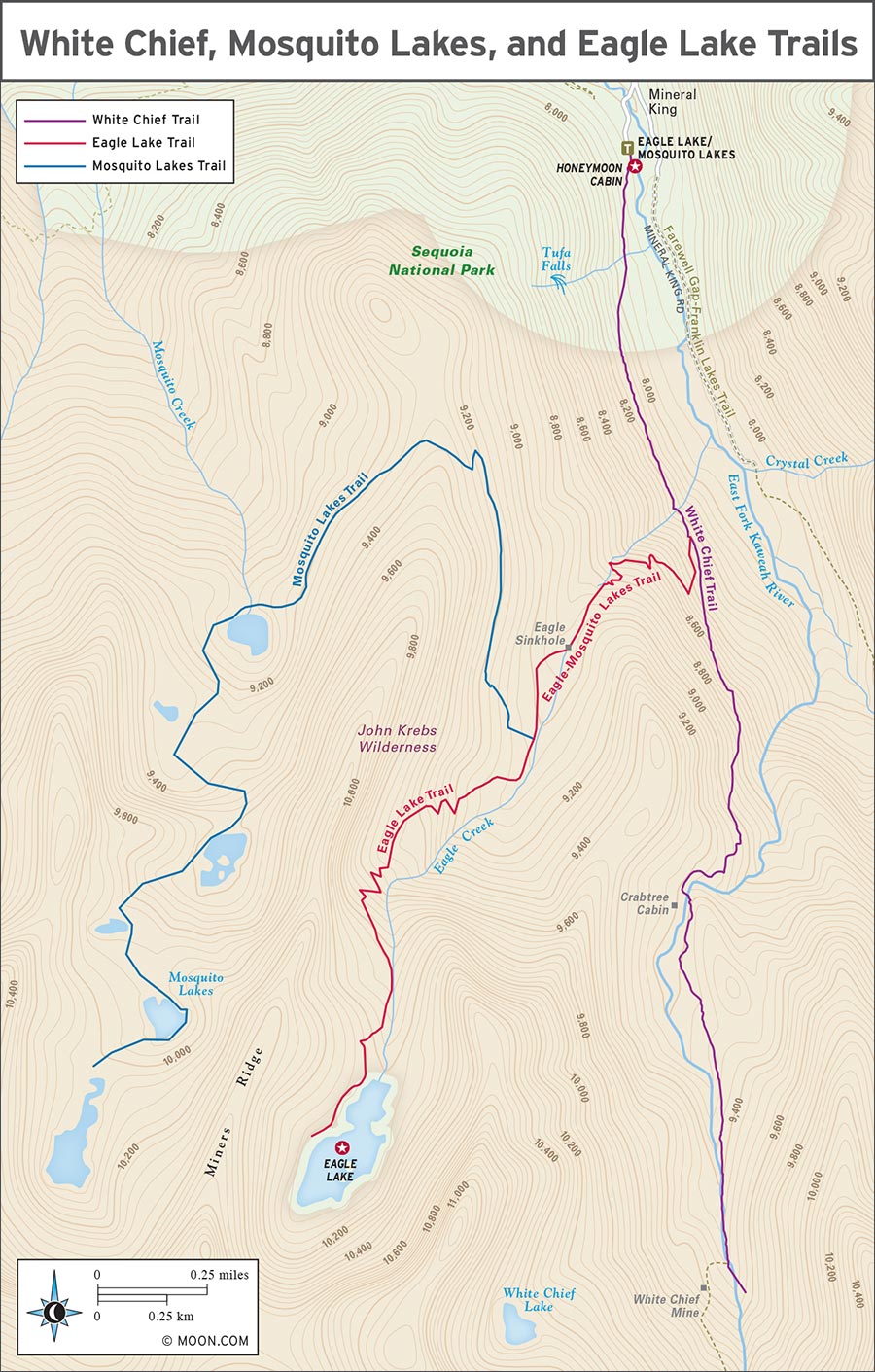
This trek occupies the western flank of the mountains that also house Eagle Lake and the Mosquito Lakes. The trail gradually climbs an east-facing slope and is more shaded than most of the other day hikes in the area. As the trail rises into a red fir forest, across the canyon you can see a wide waterfall. Views of an old mine provide a fun bit of history.
Beginning at the end of the road, start a steady, slow climb heading south. At 0.2 mile (0.3 km), you’re treated to a wildflower-encrusted gem of a waterfall, Tufa Falls. Across the canyon, looking east, is Crystal Creek Falls, an ethereal cascade running the length of the mountainside. It’s most photogenic starting at mile 0.8 (km 1.3).
At 1 mile (1.5 km), the junction for Eagle Lake and Mosquito Lakes will reduce most of the foot traffic, and you will be left alone to continue southward, climbing a tough second mile into White Chief Canyon. The views and fewer people make it worth the walk.
This trail is rich in history. At mile 1.5 (km 2.5) are the barely discernible remains of Crabtree’s Cabin, which was built by farmers trying to escape the summer heat. You’ll have to use your imagination: a century of winter weather has reduced the cabin to just a few scraps of metal.
Continue uphill, among the rare Foxtail Pines, until the trail opens up into White Chief Canyon. Just above the trail, you’ll see the remains of the White Chief Mine. The mine is over 100 feet (30 m) deep, and you can see inside the passageway miners made, but it is not safe to explore. Instead, gaze upon an unnamed dense and frothy waterfall, which appears from a band of white marble just east of the mine. When you’re ready, return the way you came.
Distance: 6.8 miles (11 km) round-trip
Duration: 4 hours
Elevation Change: 2,200 feet (670 m)
Effort: Strenuous
Trailhead: Eagle/Mosquito
Directions: From the Lookout Point Entrance Station, drive 14.3 miles (23 km) northeast along Mineral King Road, passing the Mineral King Ranger Station, to a fork in the road. Take the western fork and cross a bridge to reach a gravel parking lot. The Eagle Lake/Mosquito Lakes trailhead is accessible from the parking lot.
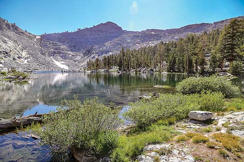
Eagle Lake
Parts of this trail are steep and a little tricky to navigate and the elevation gain adds the feeling of several more miles; plan for an all-day affair. The challenging trek to Eagle Lake is the most popular trail in Mineral King, and it’s easy to see why: It boasts waterfalls, wildflowers, huge views, cool rocks, wildlife, and a big, gorgeous lake to boot. Embrace the crowds and revel with your fellow hikers in what could be the most perfect day of your life.
From the trailhead, start with a gradual climb south up the shady, east-facing side of the canyon, where you can set your gaze on Farewell Gap. Pass Tufa Falls at the 0.2-mile (0.3-km) mark and continue chipping away at the elevation along the dirt trail. Continue around a couple of bends and you’ll be treated to an elegant wisp of a waterfall: Crystal Creek Falls tumbles down the eastern side of the valley. As you turn and ascend the trail, the angle and light on the waterfall changes, making for different and interesting photos.
At about 1 mile (1.5 km), the view opens up: Eagle Creek cuts through a meadow full of lupine, larkspur, horsemint, and more. This is a perfect place to stop and smell the flowers. When you’re ready to resume your hike, follow the creek for 0.5 mile (0.8 km) and admire the beautiful crimson columbine and orange leopard lily. (You might even see a coyote sipping water from the creek.) Hike along the trail until you reach a fork. Turn right to continue on Eagle Lake Trail (White Chief Trail continues straight) and follow it along until you reach another fork, where Mosquito Lake Trail ventures off to the right. With Eagle Creek on your left, continue your progress on the trail until you reach Eagle Lake.
Stop to admire the panoramic views from Eagle Cap to Farewell Gap to Mineral King. Swim in the lake, fish for tiny trout, or bask on the lakeshore. Return the way you came; the downhill trek goes much faster.
At the age of 40, Susan Thew took her first horsepacking trip into the wilderness and high country of what is now Sequoia National Park. With one companion, a small pack train, and her considerable determination, passion, and wit, Thew set out each summer from 1918-1926 to photograph a landscape few would ever be able to reach in person.
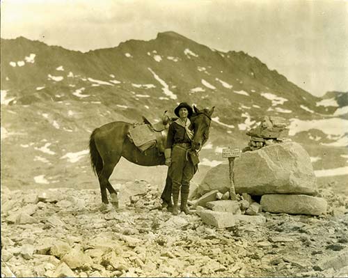
Susan Thew at Muir Pass, Kings Canyon National Park
The largest and most complete photographic record of the region to date, Thew’s gazetteer The Proposed Roosevelt-Sequoia National Park was shared with members of Congress in 1926. Later that year, due to Thew’s research and hard work, the park boundaries were extended to include the lands surrounding Mineral King: the Great Western Divide, the Kaweah Peaks, Kern Canyon, and Sierra Crest, tripling Sequoia National Park’s acreage.
Thew wrote of her experiences, “If you are weary with the battle, either of business or the greater game of life, and would like to find your way back to sound nerves and a new interest in life, I know of no better place than the wild loveliness of some chosen spot in the High Sierra in which, when you have lost your physical self, you have found your mental and spiritual re-awakening.”
Distance: 6.4 miles (10.3 km) round-trip
Duration: 4 hours
Elevation Change: 2,200 feet (670 m)
Effort: Strenuous
Trailhead: Eagle/Mosquito
Directions: From the Lookout Point Entrance Station, drive 14.3 miles (23 km) northeast along Mineral King Road, passing the Mineral King Ranger Station, to a fork in the road. Take the western fork and cross a bridge to reach a gravel parking lot. The Eagle Lake/Mosquito Lakes trailhead is accessible from the parking lot.
Following the trail marked for both Eagle Lake and Mosquito Lakes, start with a gradual climb south through a shady area with a great view of Timber Gap. Pass Tufa Falls and continue your upward trek. After turning right at the junction with White Chief Trail, you’ll progress along the peaceful switchbacks of Eagle Lake Trail, cutting back and forth across a meadow brimming with pennyroyal, horsemint, lupine, and the occasional larkspur. Take a break in the meadow (created by an avalanche!) to admire the view.
When you’re ready to continue, resume your hike as the trail continues to climb. When you reach the junction with Mosquito Lakes Trail, marked by a subtle sign just after the Eagle Creek sinkhole, take a sharp right. Most hikers will take the Eagle Lake turnoff, so you’ll enjoy more peace and quiet for the remaining portion of the trail.
Follow the trail as it continues upward. When you reach the first of the beautiful Mosquito Lakes, you can stop and turn back or continue on to access the upper lakes. The fishing is better and the lake views more stunning the higher you go. You cannot camp at the first lake, but it is allowed beginning with the second one. There is no official trail between the lakes, but enough people travel this route that you can follow informal trails through the brush. Return the way you came.
Most of the listings in the Day Hikes section can be made into lovely overnight or two-night backpacking trips. Particularly nice for beginner backpacking trips are Franklin Lakes and Monarch Lakes, but both are popular on weekends. You may find more privacy on the Mosquito Lakes or Timber Gap. Camping zones are clearly designated for each lake.
Because of the easy access for backcountry experiences, with relatively painless approaches, Mineral King is a popular starting point for backpacking. It is also easy to link with other trails, including Lodgepole and Mount Whitney. Permit quotas for each trailhead often fill up on weekends. Make a reservation at least two weeks in advance and be prepared for alternate routes if you don’t have a reservation.
Although the cold waters here are not suitable for larger creatures, the fish make up for their small size with vibrant color and energy. Many of the alpine lakes in Mineral King basin contain trout populations, and the East Fork of the Kaweah River (which was once stocked) sustains naturalized populations of brook and rainbow trout.
Eagle Lake and both Franklin Lakes are popular, reliably fruitful fishing places. Fly-fishing below Silver City Resort can be good but it’s a bit hit-or-miss. Though Soda Springs, the creek running through Farewell Canyon, is closed to fishing, try plying some of the small pools below Cold Springs Campground or Silver City Mountain Resort—but stay in the shadows; the fish can spot an angler through the crystalline waters. Other decent fishing access points include the East Fork Trail and the Lookout Point Entrance Station.
Get a California fishing license online or at the Three Rivers Mercantile (41152 Sierra Dr., Three Rivers, 559/561-2378) before driving up to Mineral King.
Mineral King’s rangers know how to put on a show. With axe in hand, rangers will start a campfire and spin a yarn to tell listeners all about the area’s storied history. Schedules for the campfire talks, as well as other talks and guided hikes are posted at the Mineral King Ranger Station.
Mineral King is a living community, having been continuously occupied for over 130 years. The dedicated volunteer staff of the Mineral King Preservation Society (www.mineralking.org) host educational picnics and a variety of programs throughout the high season, including Music on the Mountain in early August, and spooky ghost story presentations in late October. Visit their facebook page for information about specific events
The Mineral King Ranger Station (mile 24/km 39, Mineral King Rd., 559/565-3768, 8am-3:45pm daily late May-mid Oct.) sells a small selection of maps (including topographic quadrangles for backpackers), water bottles, and a few souvenirs. Proceeds go to the park. You can also get a tarp to protect your car from hungry marmots in May and June.
A visit to the gift shop in the lobby of Silver City Mountain Resort (Mineral King Rd., 559/561-3223, www.silvercityresort.com, 9am-5pm Tues.-Wed., 8am-8pm Thurs.-Mon. May-mid-Oct.) might help you find rare books about hiking and history, as well as locally made artistic wares that are not available anywhere else. Even if you’re not looking for a souvenir, the shop’s original architecture and rustic-chic decor make it worth a stop.
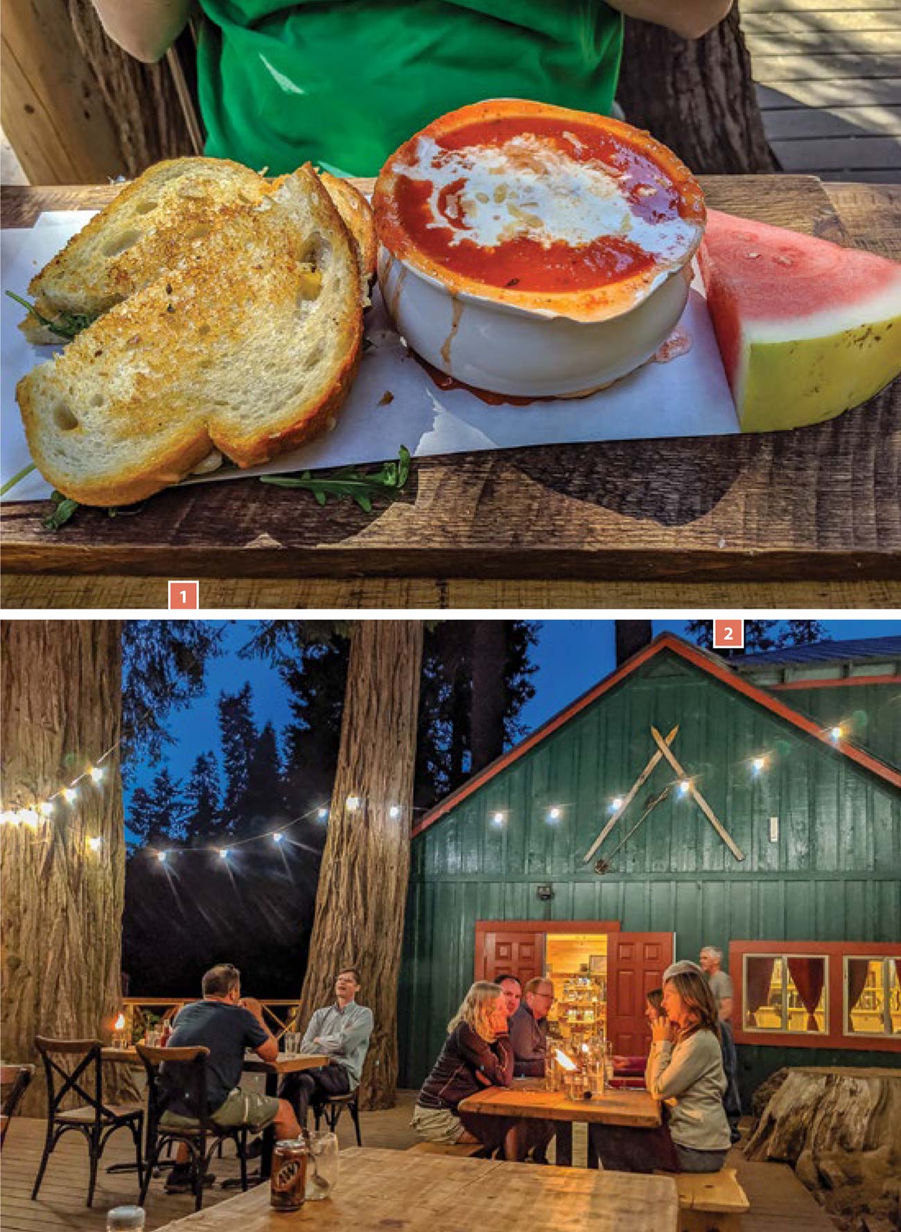
The only restaurant in the area is at the Silver City Mountain Resort (Mineral King Rd., 559/561-3223, www.silvercityresort.com, 8am-7pm Tues.-Wed., 8am-8pm Thurs.-Mon. May-mid-Oct., breakfast $8-18, lunch and dinner $10-20). Surrounded by trees and twinkling lights, the resort’s dog-friendly porch doubles as a casual restaurant. Grab a fresh-squeezed mimosa or a pint of California craft beer and start a horseshoes match or conversation with your neighbor. The atmosphere is light, friendly, and family-oriented and the food is just as delightful. The menu highlights local, Central Valley ingredients, like beef from Harris Ranch and produce from Flora Bella Farms. The greatest treat to end brunch, lunch, or dinner is a slice of homemade pie: chocolate walnut, berry, and apple are all part of the rotation. The resort also offers clean and comfortable cabins ($125-400) that are best described as logger chic: wooden cabins with modern bathrooms, fresh linens, and a forest-based color palette of dark greens and warm tans. The cabins are set close together on a hillside, but there’s still privacy. About half of the cabins have private bathrooms and electricity. The shared bathrooms have hot water, and the resort provides any toiletries you may have forgotten.
Mineral King is a tent camper’s paradise: serene and quiet. Whether you choose to pitch your tent at Atwell Mill or Cold Springs, you’ll be minutes from world-class hiking. Both sites have potable water, vault toilets, fire pits, picnic tables, food lockers, and pay phones. No RVs can make the trip into Mineral King, which means no generators will be whirring and echoing throughout the campgrounds. Pets are permitted on leash at both campgrounds. There are no reservations accepted for either campground; all sites are first-come, first-served. For holiday weekends, arrive early on Friday. You can self-register for a campsite at the entrance to Mineral King, Lookout Point. (Be sure to clip the ticket from your registration to the post at your driveway to show that your site is paid for and occupied.)
The only campground where you can sleep beneath the stars and the sequoias is Atwell Mill (mid-June-late Oct., $12). At 6,600 feet (2,010 m) of elevation and 6 miles (10 km) from the end of Mineral King Road, 21 sites sit in a forest of sequoias away from the winds of Mineral King Valley and nestled into a pocket of meadows. This is one of the quietest places to sleep in the front country. It also provides great access to the Hockett Trail (near campsite 16). Site 11 is a wheelchair-accessible site. Site 12 is tucked away and overlooks a meadow. The nearest supplies are 1.5 miles (2.5 km) away at Silver City Mountain Resort.
As you camp along a creek with great views of all of Mineral King’s majesty, you’ll feel luckier than a miner striking pay dirt. Cold Springs (May or June-late Oct., $12) is close to the Mineral King Ranger Station and offers access to fly-fishing in the East Fork of the Kaweah River. Choose from the 31 sites with drive-up access or the 9 walk-in sites, which are 100-200 yards from the parking area, and offer more privacy. This campground opens later than Atwell; the opening date is dependent on the snow levels. Some of the best sites are available by turning right after the bridge. The nearest supplies are 2.5 miles (4 km) away at Silver City Mountain Resort. From site 6, an easy, wildflower-filled nature trail offers views of the whole valley while following the river.
Be cautious while driving in Mineral King. Take your time along the partially paved, single lane roads with blind curves and steep hillsides. Don’t brave the roads at night.
It may sound strange, but when the area’s marmots emerge from winter hibernation in spring and early summer, they’re known to chew car wiring and hoses in order to sate an instinctual craving for salt and minerals. They can cause a lot of destruction, so if you’re planning to park in the area, protect your car in wrapping it with a tarp. Be sure to cover the undercarriage and wheel wells in particular. A few tarps are available to borrow at the Mineral King Ranger Station, but it’s best to buy your own in advance before entering the park. It is possible for marmots to crawl in, even if you’ve used a tarp. When you first turn on your car, listen for any strange noises; report marmot-caused damage to the rangers.
The only way to enter Mineral King is through Three Rivers, making it the best place to stock up on food and ice. The main grocery store in Three Rivers, Three Rivers Village Market (40869 Sierra Dr., 559/561-4441, http://threeriversvillagemarket.com, 8am-8pm daily), has the best selection and prices in the area. It’s on the north side of Highway 198 as you enter town. Visalia and Fresno both have large chain grocery stores near the highway and en route to the park.
If you need some lip balm or pain relievers, Silver City Mountain Resort (Mineral King Rd., 559/561-3223, www.silvercityresort.com, 9am-5pm Tues.-Wed., 8am-8pm Thurs.-Mon. May-mid-Oct.) probably has it in their small souvenir shop. The Mineral King Ranger Station (mile 24/km 39, Mineral King Rd., 559/565-3768, 8am-3:45pm daily late May-mid Oct.) carries some resources for campers beyond maps, books, and bear cans. Unfortunately, the ranger station does not have a wheelchair-accessible entrance.
There is no gas in Mineral King. Before entering the park, you can fill up in Three Rivers at Shell (41729 Sierra Dr., 559/561-4113).