CHAPTER 16
Restoring Natural Water Systems
One of the most changed processes in the landscape is the water cycle. Watersheds in the East that once absorbed over 85 percent of the precipitation they received to support aquifers and stream flow now shed that amount or more as runoff because watersheds have been deforested and cleared for fields and farms or converted to pavement, turf, and rooftop. In parts of the arid West, where water rights are bought and sold as property, water tables have dropped as much as 300 feet or more in this century alone. Yet we continue to render the landscape less permeable as well as increase consumption and waste of water resources.
Our greatest mistake in managing water in the past has been to focus on single issues like flood control or erosion rather than the larger system. We now understand, however, that every action in the natural world has many ramifications throughout the whole system. This is nowhere so immediately evident as when we are dealing with water. One property owner fills his land to protect it from flooding, only to divert those floodwaters to a neighbor’s property that then becomes more vulnerable to flooding. Another bulkheads his land to save a shoreline and dramatically increases the shoreline losses of an unarmored adjacent site. All these actions as well as their consequences have severe negative impacts to the forest, from subtle shifts in population composition because of altered hydrologic regimes in the landscape or the sudden blowout of a stream channel and the vegetation along its banks from uncontrolled stormwater.
Therefore, we must restore the patterns of water that have shaped the landscape if we wish to restore the forest. The first step is to look at water as a system. The second, which follows from the first, is to recognize that we do not know how and cannot afford to replace the functions and services of natural water systems. A great flaw in the regulatory system as well as conventional planning and construction is the failure to recognize and protect the whole spectrum of values of a natural system.
When we recognize the way water works, we will no longer separate aspects about the quantity of water, such as flooding and erosion, from those related to the quality of water, such as biological pollutant reduction. They are ultimately related. The riparian, or floodplain, forest, for example, not only slows water’s velocity, but it also reduces and attenuates the quantity of runoff by holding water in the floodplain on its vast surface area of leaves and limbs as well as through transpiration. The forest also treats runoff by filtering pollutants, using nutrients, breaking down petrochemicals, and reducing oxygen demand. When that forest is cleared, we lose the biological treatment system that was in the vegetation. When a stream corridor is exchanged for a pipe under fill, the worth of what we are losing — habitat, flood control, and water purification — often far exceeds the value of what we are trading for it, a few additional square feet for construction in a landscape that is already overbuilt.
The biggest problem is almost always that too little land has been left to natural patterns. Stream courses, wetlands, and floodplains in many urban and suburban areas have been constricted and buried by filling, paving, and structures until all that remains of them are steep-sided stream channels with no real floodplain corridor left at all. Because the conventional engineering perspective has defined stream function almost solely by the capacity to convey water, our regulations are gradually producing streams that are more like pipes or flumes. There is inadequate regulatory protection for a natural stream corridor, which has intrinsic value beyond the functions of flood storage and drainage: as plant and animal habitat and for pollutant reduction through biologic treatment.
Wetlands protection has been under continuous assault since its inception, no less so now. With over half our nation’s wetlands gone, there are still strong incentives for landholders to encroach upon, fill, and drain them. Forested wetlands are especially vulnerable, and nearly all would have been removed from even the most minimal protection under the recently considered definitions of wetlands at the federal level.
Opportunities to save wetlands are frequently overlooked, even when we can do so at minimal cost. Little more than one-quarter of the nation’s wetlands are publicly owned, yet virtually none of the wetlands acquired by the Resolution Trust Corporation after the savings and loan failures were given long-term protection. All, including extensive forested wetlands, were instead turned back over to private entities, unprotected, often at a fraction of market value.
Floodplains are no less imperiled. Despite public awareness about the problems of building in floodplains and along shorelines and despite demonstrable cost savings to municipalities and agencies in limiting development, construction funded by both public and private investment continues in flood-prone areas, most of which should be returned to forested conditions. Ultimately, the public bears most of the costs of floodplain mismanagement. At the same time, no actions are taken to reduce actual risk, making it all the more likely that property and casualty losses will be great, whether the insurer, the taxpayer, or the individual pays the bill.
The problems of flooding, tornados, and other climate-related catastrophes will only worsen with continued global warming. Because there is more heat, there is more energy driving global climate patterns, and the consequence is increased storminess. The effects of the extent of warming already have been evident for years and take a severe toll on natural environments as well as built infrastructures and property. Remnant forests along stream corridors that already experience severe erosion from runoff will be further stressed by more extreme storm events.
Resource protection benefits the whole community, but not directly the owners of natural resources such as wetlands, for example, who have little or no financial incentive to preserve land. We have invested a great deal of public money to build an engineered infrastructure at the same time we have been dismantling the natural infrastructure. This approach has failed miserably, and at great cost. The built infrastructure is already crumbling from lack of maintenance while consuming ever more tax dollars for expansion. The shifting hydrologic conditions created have degraded natural environments in uplands as well as lowlands. It is now time to turn the tables, to provide for water retention and infiltration within the fabric of development, rather than shunting everything to the stream. Rather than investing in trapezoidal ditches and costly concrete bunkers that provide no infiltrational reduction in contamination, we can meet those goals while protecting forest and reconnecting stream corridors and wetlands. We can reestablish a landscape rich in intermittently wet places. Such an approach recognizes the fundamental irreplaceability of the natural water infrastructure, its biotic richness, and its cost effectiveness over an engineered alternative. We cannot sustain natural ecosystems without restoring the historic hydrologic conditions that depend on this natural infrastructure.
Strategies for Restoring Hydrologic Patterns
We must take every opportunity to enlarge natural stream corridors wherever possible, and certainly in any restoration project. There is no doubt about the value of protecting a stretch of stream corridor and nothing but rewards to reap. Unlike the removal of exotics, which may in some places prove futile or even counterproductive, sustaining the basic patterns of natural drainage in the landscape is vital to every endeavor related to ecosystem restoration.
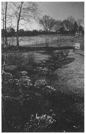
A substantial proportion of the stream corridor must be kept in a relatively natural state to retain all its functions: pollutant reduction, flood retention, fish hatchery, plant and animal habitat. Ideally, the entire floodplain as well as a buffer strip should be protected in addition to a sufficiently wide corridor to protect the most demanding local species, which will vary with context and scale. In an urban area, the amount sought often depends upon opportunity: how much is left unprotected, how much could be acquired, and how much is restorable. On a smaller scale, restoration may include taking a stream out of a pipe, reestablishing a natural meandering channel, and planting trees along the stream corridor as well as optimizing the opportunities for infiltration and storage in the uplands (Figures 16.1 and 16.2).
Reestablishing more natural patterns of drainage ultimately requires modifications in the management of landscapes throughout whole watersheds, relying on multiple solutions at many different points, rather than a single cure-all at the point of discharge. Once the problem has reached the stream, it is too late. The solutions lie throughout the watershed, and entail actions that range from protecting and reforesting stream corridors to eliminating lawn and replacing it with meadow or woodland.
This guidebook recommends six strategies to restore and manage natural water cycles in the landscape. An essential part of any restoration project — before work begins and throughout the project — is to plan and evaluate any actions in the context of these strategies:
- The water budget as a management tool — Monitoring the whole system
- Restoring historic drainage patterns — Sustaining and reestablishing natural drainage patterns
- Stream restoration — Sustaining and reestablishing natural water courses
- Changing landscape type — Changing vegetation to reduce runoff
- Alternatives to turf — Creating open landscapes that have fewer negative impacts
- Dispersed, small-scale storage and filtration — Restoring and creating new wetlands
You can apply these approaches at a variety of scales throughout the watershed in and beyond your project area. All of the strategies described in the remainder of the chapter respond to the consequences of development patterns in the temperate region and the resulting need to foster more natural hydrologic regimes by reducing the impermeability of the land surface. While correcting the problems of water management goes well beyond the scope of this guidebook, following the recommendations in this chapter will work to mimic natural patterns of rainfall and runoff. If the goals of retaining runoff and maximizing recharge are vigorously pursued in the uplands, the problems of erosion, sedimentation, flooding, and falling water tables and base flows in lowland areas will become more manageable.
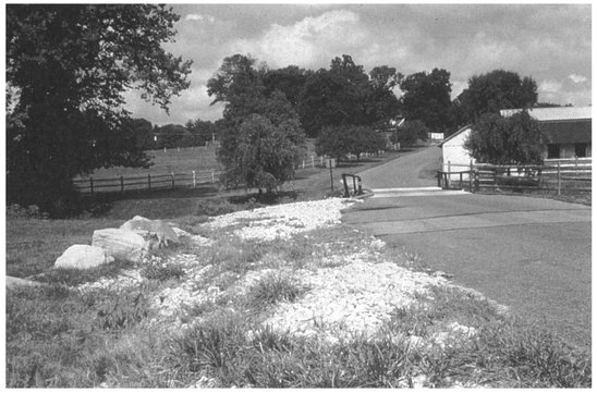
Figure 16.1. The swales along this roadside edge had been “stabilized” with dumped stone although the arrowhead plants of the earlier wetlands still showed through.
Figure 16.2. The wetland swales reestablished along the roadside treat a significant amount of contamination in stormwater before it reaches natural wetlands.
The Water Budget
Our efforts to sustainably manage water resources over time will depend to a great degree on how well we understand the workings of the larger system. Many of our worst decisions, in hindsight, reveal that we really did not know, or ask, where the water would go. Ignoring the small but high-frequency storm has resulted in a landscape of gouged stream channels that now run like torrents after even a minor storm. Any decision about drainage, flood control, or water treatment will have implications for other components of the system, implications that can only be appreciated when we have a model of the whole system.
Anyone concerned with water management must understand the comprehensive water budget of the environment, not just specific factors such as design floods. Instead of single aspects of water management, we must seek to quantify the interacting components of the system.
A “water budget” for the landscape attempts to model the whole system over time and includes all major water inputs and outputs. Typical inputs include surface flow from streams and creeks plus other runoff onto the watershed or site, subsurface inflow from groundwater moving into the landscape, and precipitation (rain or snow). Typical outputs include surface outflow, which includes water moving in streams, creeks, ditches, and pipes; subsurface outflow (which is moving as groundwater); and evaporation and transpiration (from plants). In most landscapes, this natural pattern has been overlaid and modified by an engineered system of channels, pipes, and other outflows that must also be included in the model. Irrigation may be another input that also has to be incorporated into the model.
You can model a site or a region. The best models relate multiple scales of information for cross-comparisons. Do, for example, the quantifications used for local-scale basin design and stormwater management regulatory criteria confirm or correspond well to regional-scale data and models? If performed on an ongoing basis, such an evaluation allows us to integrate the monitoring that is undertaken for individual sites as well as data gathered by agencies and nonprofit organizations to create a regional database or model of how water really works in that area and that grows more accurate over time. The process of refining the water budget also helps to identify the work that is accomplished by natural systems.
Historical Drainage Patterns
Sustaining and restoring landscapes depends on restoring and protecting historic patterns of drainage. One reason is that the reproductive cycles of organisms are timed to take advantage of seasonal variations in drainage regimes, such as flooding cycles. For example, the great galleries of cottonwood trees that overhang the bluffs of a flashy prairie stream germinate in the mineral soil exposed by rushing floodwaters. With effective flood control, however, this natural disturbance has been tamed, so all too often there are no young streamside cottonwood forests to replace the few ancient ones that remain. Here in the East, on the other hand, established floodplain vegetation has been disturbed by erosion and collapsing streambanks. In both cases, the conditions that fostered the regeneration of the historic landscape no longer occur.
Everywhere in our urban and suburban communities, the landscape infrastructure has been left out of our codes and ordinances. We need “green” site standards as well as “green” building standards to achieve real sustainability. Effective watershed protection requires a more comprehensive approach than largely piecemeal development projects and a few big and costly government projects to implement a water management plan. In a more environmental approach, design standards for engineers would seek levels of soil recharge and rainfall infiltration comparable to those that occurred under historic forest conditions as well as effective pollutant reductions. Implicit in this approach is a recognition that the pattern of the natural stream network is an irreplaceable ecosystem infrastructure, that sustaining natural systems within the fabric of development will depend upon our preservation of the natural infrastructure that supports them.
This change in perspective need not be deferred until some future time. Today, using computer modeling and new software, we can tailor an engineering design to the specific conditions of a particular stream and watershed, rather than to a more simplistic regulatory standard. By monitoring and modeling historic and future patterns of drainage we can use the capacity and requirements of the receiving stream, not the anticipated volumes of runoff generated by a site plan, to define engineering standards for a site.
To recover natural hydrologic conditions, at whatever scale we are working, means learning how the land once looked and functioned. Each site has an inherent geometry that reflects its role in the historic water patterns of the regional natural system. Each site has its place in the larger context. It is not a microcosm or a statistic of the larger region; it is an element of the region, and its role in that region needs to be recognized and preserved.
Stream Restoration
A primary rule in stream restoration is not to destabilize the banks in the name of stabilizing them. Vegetation is often cleared along a stream bank for any number of reasons: to reduce the weight on unstable slopes (by removing heavy trees, for instance), to allow easier visual inspection of stream bank conditions, to allow for unobstructed views, or to make it neat.
Trees are often removed in the belief that their roots create de facto “pipes” that convey water and undermine the stream embankment. The trees, however, may be all that is holding the slope. In fact, dead roots of cleared trees serve as pipes far more effectively than living roots, an effect that persists for decades, so clearing a slope or embankment that is wooded generally creates more problems than it solves.
The desire to improve trout habitat is often the primary incentive for stream restoration efforts. Trout, in addition to a steady flow of water, require food, shelter, and cover, as well as areas suitable for reproduction. Sustaining a forested stream corridor is an important component toward meeting these requirements. A forested stream corridor improves water quality and helps retain stormwater and control sediment. Sediment control is vital because many of the insects that are trout’s preferred food, as well as the trout themselves, need well-aerated, silt-free areas to feed and reproduce. Shaded streams are also cooler and provide better cover. The forest’s leaf fall is an important source of detritus, the base of the stream’s food chain, as well as the insects and other creatures that fall from branches overhanging the water.
Most of our problems with streams stem from fighting their inherently dynamic quality, of resisting their tendencies to meander, to flood, and to change course. George Parmentier, a noted stream restorer, pioneered an approach to stream restoration that utilizes those very processes to harness the stream’s own energy to accelerate its return to its former condition: he re-creates natural stream meanders in channelized and/or stormwater-gouged streams by using the large mass of felled tree trunks to deflect the flow of water. By placing a sequence of trunks and root masses to veer the water more deliberately back and forth, he re-creates a longer stream channel and with it many of the stream’s former characteristics. His approach mimics natural processes of the past that shaped the character of streams, the major storms that toppled trees as well as the actions of beavers.
This same kind of approach is used extensively for large-scale stream restoration on previously logged land as well as in urban areas. Clearcutting creates many of the same problems for a stream that development does, leaving banks gouged by increased runoff and a sharply incised channel. The use of large tree trunks, large rocks, and other natural debris in the channel, rather than old tires and rebars, can help check flows and allow sediment deposition to gradually bring the stream back in touch with its banks. These debris dams shift over time under natural conditions and should not, in general, be anchored in place except temporarily.
Deflectors are structures that jut into the channel and change the direction of stream flow. They can be made of stone, logs, or reinforced soil. A live boom is a bioengineered deflector made of soil and living plants set in the stream’s path. Deflectors may be used in a variety of situations. For example, where there are two channels, neither with adequate flow for good fish habitat, a deflector system may be used to block one of them to increase flow in the other. Deflectors of logs, half-logs, or boulders may be used to improve cover for fish. Low (12- to 18-inch) dams that create a plunge pool below them also serve as good cover and aerate the water.
Stream corridor protection overlaps many different programs and jurisdictions. Restoration as a primary objective can serve to integrate existing efforts better than the current, more fragmented regulatory approach. Already-existing agricultural policies and farm programs can assist in the effort. Over 30 million acres have been enrolled in the federal Conservation Reserve Program since 1985, which takes marginal land out of cultivation. Researchers estimate that this land left fallow or reforested may be able to remove from the atmosphere nearly half of the carbon released by agriculture annually in the United States. In addition, this program can reduce erosion by one-quarter billion tons (Gebhart et al. 1994) by taking highly erodible land out of cultivation.
Simply using grass to filter sediment and break down nutrients is an important landscape strategy for managing non-point sources of pollution, which could provide added habitat opportunities as well. Wide swaths of natural forest are even more effective than grasses at reducing pollutant loads. Although ineffective at reducing or compensating for wetland loss, the Swampbuster Program, another federal effort similar to the Conservation Reserve Program, has enormous potential, with some modification, to be a major vehicle for habitat restoration. Both programs need to be reinforced with acquisition through purchase and increased attention to habitat restoration and management, not simply set-asides of acreage (McElfish and Adler 1990).
Changing Landscape Type
The most straightforward way to restore natural hydrologic patterns is to reforest as much of the watershed as possible. When you look for the areas that might be returned to forest, you will find many and varied opportunities, from roadside margins and vacant lands to closed landfills and mines and waste sites to cemeteries, schoolyards, and front or backyards. While beginning to work on marginally useful sites, though, we should also concentrate on enlarging and connecting existing areas of forest and forest corridors along stream channels.
Reforesting efforts like these make a significant difference. The Natural Resources Conservation Service recently evaluated about 18 miles of the Winooski River in Vermont that was stabilized and revegetated through soil bioengineering techniques from 1937 to 1941. Although the original plantings have long since disappeared, a forest has grown up along these once-barren stream banks where techniques that are underutilized today (and described in Part III) were used to reforest the corridor.
All scales are important and add to the cumulative effect. Boy Scouts, as part of the Cache River Restoration in Illinois, planted over 2,000 pounds of acorns in a single season. Along the Middle Run Creek, volunteers from the Delaware Nature Education Society planted 700 trees in a single day as part of an ongoing reforestation program.
These projects offer the opportunity to expand habitat for many creatures favoring successional habitats, which all too often have been diminished by the modern wave of suburban development. When there was more forest and logging was more common, a region almost always contained a patch at every stage of succession, providing habitat, for example, for vireos and redstarts. Today, large-scale sites such as corporate office parks, golf courses, and historic estates could convert substantial areas of lawn to tall-grass meadow and savanna and young woodland to provide successional landscapes for species that depend on them.
We still need to develop effective installation techniques for native woodland communities. When erosion- and sediment-control regulations were enacted, rapid establishment of vegetative cover was required. The emphasis in research, as well as practice, shifted from trees to grasses (Smith 1980). This trend is changing once again with greater interest in and funding for reforestation. The next step is not to plant exotics, such as Norway maple, but rather native species.
Alternatives to Turf
It is remarkable how ubiquitous turf has become, considering how expensive it is, not only environmentally but also economically. On average, suburban landowners use substantially more herbicides and pesticides than farmers. In fact, ten times the herbicide is used in landscape maintenance than by all agriculture, most of it unregulated. The average acre of well-tended lawn costs approximately $500 to $5,000 a year to maintain. It is cheap to install, however, and the technology is widespread and nearly universally accepted. The lion’s share of the grasses-related research dollar, both public and private, has gone to turf varieties while far less has been spent on experimentation with native grasses.
Simply altering the management of landscapes, such as replanting forest and reducing the area of turf, substantially reduces runoff. Turf areas, when even only gently sloped, shed water nearly as rapidly as pavement. A lawn is not only a preempted natural area but often means a lot of fertilizer, lime, herbicides, and oil and gasoline from mowers polluting nearby natural landscapes by way of runoff. Reducing the extent of lawn is one of the easiest and most effective ways of addressing stormwater management while increasing the area of potential wildlife habitat (Figures 16.3 and 16.4).
Changing our attitudes toward lawn may be one of the most important things we can do to save the eastern forest. Not only could we clear far less land for development purposes and save more forest in the first place, but we could also help protect the quality of those areas of forest that are preserved.
It is very common in parks and other landscapes for lawn to extend right up to the edge of a steep wooded hillside. By maintaining a simple margin of meadow as a buffer between turf and forest, you can reduce runoff, and, in turn, reduce erosion and sedimentation. A strip of meadow paralleling the forest edge also helps reduce the likelihood of off-trail trampling, which turf often invites. Turf trails through the meadow edge can be used to direct pedestrian movement to the legitimate trails instead of desire-line or outlaw trails that further concentrate stormwater. By avoiding the use of lawn grasses, you can more readily maintain the areas under groves of trees or large specimens in a parkland setting as tall grass and greatly reduce the amount of hand labor required for trimming and the damage done to mature trees by mowers. Too many patches of turf end up being mown over and over simply because no one challenged that notion or made the effort to establish some other landscape in their place.
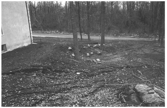
Figure 16.3. The seeded lawn and substantial amounts of soil washed away completely after one heavy rain on this steep, newly deforested lot.
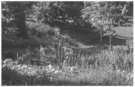
Figure 16.4. Wildflowers, ferns, and many seedling-size trees and shrubs now create a successional meadow that retards runoff and will gradually replace the lost understory layers of the landscape.
The primary obstacle to the use of native grasslands and meadows is the lack of simple, effective establishment and maintenance methods. There are two major problems. First, the Northeast has no local, large-scale seed production nurseries; and second, in most instances regulatory agencies do not require or recommend native species. Part of the problem stems from the regulatory requirement to provide erosion control rapidly. Because native grasses, like woody species, typically develop slowly at the outset, agencies have often overlooked them in favor of faster-germinating, early season exotics. Energy and money went into methods that promoted quick stabilization, not longer-term solutions.
It is certainly time to master new techniques. The establishment of native grasslands, tolerant of extreme soil conditions, is a more appropriate objective for many sites. We do not suggest that short-term erosion control should be sacrificed to these longer-range goals, but rather that we need to develop more comprehensive and cost-effective techniques for establishing native plant communities that also meet the needs of immediate erosion and sedimentation control.
Dispersed, Small-Scale Storage
Remarkably many opportunities exist for very small scale storage of water. Intermittently wet places that provided special habitat were once common in the natural landscape, but we have graded away many of these low spots and wet places, which now persist only as puddles in asphalt and water in backed-up storm drains. Small swales (shallow drainage channels) and ephemeral wetlands provide a high degree of storage as well as pollutant reduction, and they can be repeated throughout the landscape. Small impoundments are probably the simplest to construct and can be designed as richly vegetated amenities. Replicating the condition where a fallen log or large branch, for example, slows the flow of water from a small section of hillside helps stabilize the landscape. Each such structure contributes to re-creating more historic drainage patterns.
The value of isolated wetlands that are not necessarily connected by a visible stream network but are rather supported by groundwater or seasonal surface water is generally not recognized today. These include vernal pools, which are usually small (less than 2,000 square feet), shallow (less than 1 foot), and typically contain standing water, usually in the spring, for at least two months but are dry at least part of the year. And because they are small and temporary, they support important breeding populations of amphibians and invertebrates, including fairy shrimp, the burrowing mole salamanders, and wood frogs, that do not survive in larger, permanent pools that must be shared with predators such as fish and bullfrogs. We have lost countless of these ephemeral pools, but they can often be partially re-created where woodland habitat still remains as long as there is a relatively steady supply of groundwater or sediment-free surface water. In addition, restoration efforts need to direct attention to the creation of new wetland and lowland habitats — not just as mitigation, but to compensate for past losses (Figures 16.5 and 16.6). Unfortunately, landowners often avoid wetlands establishment for stormwater management purposes in the fear that the land would then be subject to wetlands regulations. New ordinances that encourage wetland creation as well as the retrofit of existing stormwater facilities to create more natural habitat are obviously needed.
New wetlands can also help provide adequate levels of water treatment to allow for groundwater recharge or direct discharge without further contamination or stress to existing systems and remnant habitats. This allows water to recharge ground and surface aquifers to restore historic patterns rather than requiring transport for treatment and nonlocal discharge. Created wetlands are being used successfully to treat acid mine drainage and sewage effluent and are increasingly incorporated into stormwater detention facilities as concern about non-point-source pollution grows. The National Academy of Science has set a goal of a net increase of 10 million acres in wetlands nationally as part of a broad strategy to restore surface-water quality (National Research Council 1992). The restoration of these wetlands will contribute greatly toward restoring historic drainage regimes on which many plant and animal communities depend.
Using created wetlands for biological treatment of contaminated water, whether wastewater or stormwater, is often perceived to be too land-intensive and may be ruled out where available land is in short supply. The reality, however, is that large amounts of land are simply wasted virtually everywhere in the landscape. Lawn is but one obvious example; the typical highway illustrates other overlooked opportunities. The roadside landscape, both upland and disturbed lowlands, can and should be the first treatment system for road runoff. Instead it is typically turf, often mown well beyond what might be required for visibility, further contributing to the rate of runoff. Runoff is collected and conveyed by grading and pipes, rather than retained for use in vegetated landscapes (Figure 16.7).
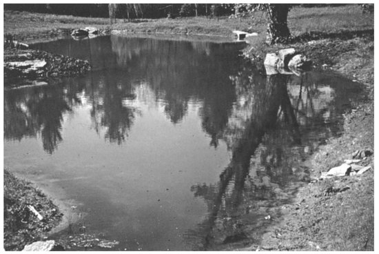
Figure 16.5. After regrading, this once steep-sided pond now includes a smaller, upstream pond for sediment collection and shallow banks providing ample habitat for replanted native communities.
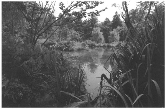
Figure 16.6. Rootstocks of wetland species grew profusely the first season beneath the thin canopies of the future swamp forest that was planted at the water’s edge.
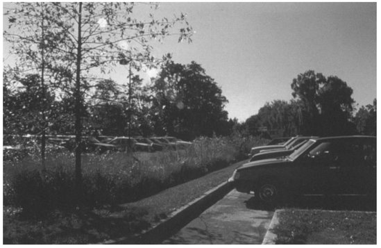
Figure 16.7. Broad shallow swales with native grasses between parking bays allow for stormwater infiltration and pollutant reduction.
Rather than conserving and treating water at roadsides, we often turn them into deserts. For example, here in the East, where rainfall is abundant, xeriscaping has recently become popular for coping with roadsides and other desiccated landscapes created by modern construction approaches. Xeriscaping is a planting technique best applied in areas of low rainfall because it employs species adapted to those conditions to minimize or eliminate irrigation. Sometimes it takes an extreme form where bare gravel and no plants are used with repeated herbiciding to maintain the barren state. In the East, a more appropriate method than using plants adapted to dry conditions or gravel would be to stop creating dry conditions and to see water, even road-contaminated stormwater, as a potential resource to be conserved and recycled in the larger system (Figures 16.8 16.9 16.10).
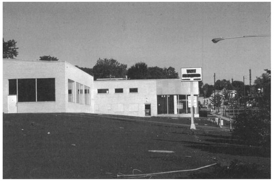
Figure 16.8. The retopping of this parking lot provided the opportunity to remove all unnecessary paving with no reduction in the total number of spaces.
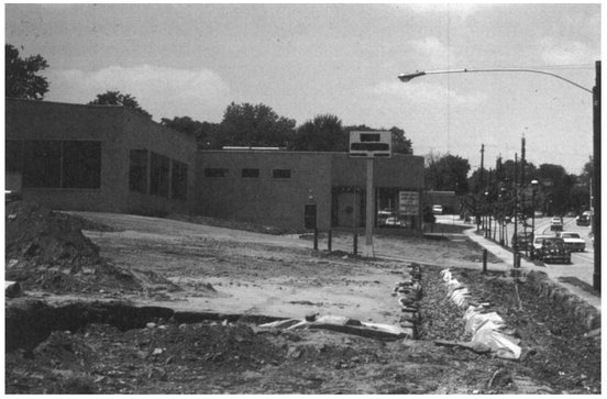
Figure 16.9. Infiltration trenches, dug at the margin of the parking lot and filled with the uniform-size stones, collect and filter runoff from this lot.
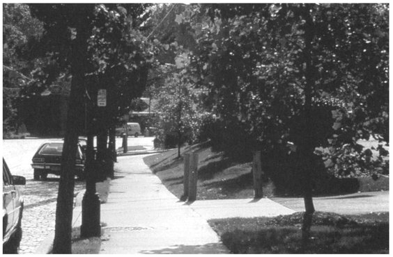
Figure 16.10. The larger soil area affords the opportunity for a substantially improved environment for street trees.