The Western Mediterranean
The complex Alpine–Himalayan orogenic belt extends from the Atlantic Ocean at Gibraltar in the west to Myanmar (formerly Burma) on the eastern shores of the Indian Ocean (Fig. 4.1). It has been produced by the collision of three separate plates: the African, Arabian and Indian plates in the south, with the Eurasian Plate in the north. The shape of the belt is sinuous, and complex in detail, consisting of a large number of separate mountain chains, which in places enclose relatively flat, high plateaux, low-lying plains, and even ocean basins, such as those in the Western Mediterranean and the Black Sea.
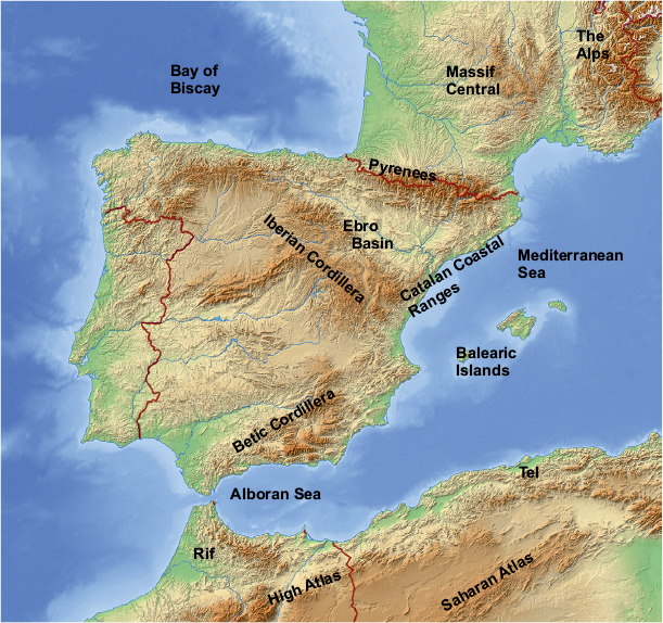
There are three major mountain chains within the Western Mediterranean sector of the Alpine–Himalayan orogenic belt: the Pyrenees, the Betic Cordillera (or Betic Alps) in Europe, and the Atlas–Rif–Tell ranges in North Africa (Figs 4.2, 4.3). Two other less prominent ranges occur within the Iberian Peninsula: the Iberian Cordillera and the Catalan coastal ranges.
This western sector of the orogenic belt resulted from the convergence of Africa and Europe, which took place during a period of around 180Ma, beginning in the middle Jurassic Period, and culminating in the Miocene Epoch around 20Ma ago. Movement is still continuing, though at a much reduced rate of less than 10mm/a (per annum), and the area is subject to frequent earthquakes and vulcanicity. This essentially convergent movement was very complex in detail, and this partly accounts for the sinuous and complicated shape of the belt overall. Several crustal blocks (termed ‘terranes’) broke away from both the European and African margins and travelled independently as ‘microplates’ to form separate collisional units. Another complication was caused by the opening and spreading of several small oceanic basins within the orogenic belt, producing further distortions in its shape.
Figure 4.1 The Alpine–Himalayan orogenic belt. This belt is composed of many separate mountain chains that have been produced by collisions of three southern plates: African, Arabian and Indian, with the Eurasian plate in the north. In many places, the belt consists of northern and southern strands separated by lower-lying undeformed plains, or even ocean basins such as those in the western Mediterranean and the Black Sea. Ap, Apennines; BS, Black Sea; HA, Hellenic arc; Kar, Karakoram; My, Myanmar (Burma); Pam, Pamirs.
Figure 4.2 Mountain belts of the Western Mediterranean. Shutterstock©Schwabenblitz.
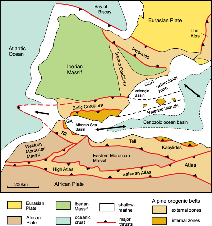
Figure 4.3 Alpine orogenic belts of the Western Mediterranean. GA, Gibraltar Arc; CCR, Catalan Coastal Ranges. After Sans de Galdeano, 2000.
200 million years ago, at the end of the Triassic Period, the Earth’s surface would have appeared completely different to an observer viewing us from space. All, or almost all, of the continental crust was combined into a single supercontinent, Pangaea, which was composed of a northern grouping, Laurasia, and a southern, Gondwana. A worldwide ocean completely surrounded Pangaea and projected into it in the form of a large embayment known as the Tethys Ocean, which separated most of what is now Asia from the Arabian part of Gondwana (Fig. 4.4A). The floor of this ocean has completely disappeared, and parts of its oceanic crust, together with its sedimentary cover, have been incorporated into the various mountain chains. The present-day Mediterranean Sea, much of which is underlain by oceanic crust, is a more modern ocean, created during the Alpine orogeny, and known as the Neo-Tethys Ocean. The Alpine–Himalayan orogenic belt records the history of the break-up of Pangaea and the re-arrangement of its component parts into a different configuration.
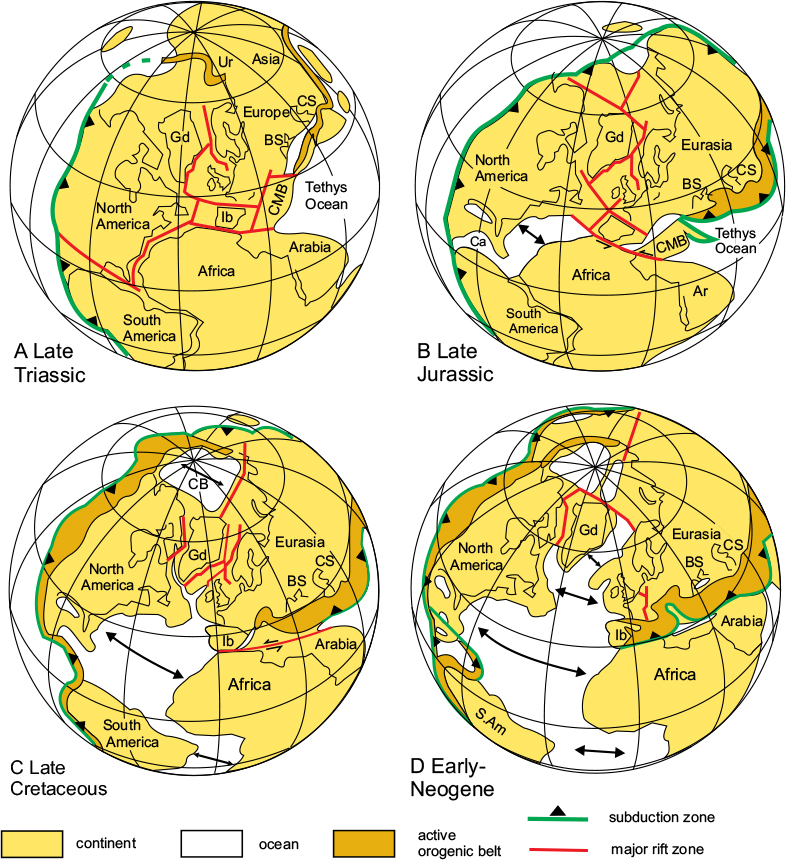
Figure 4.4 The break-up of Pangaea. Position of the continents during the Mesozoic and Cenozoic Eras. BS, Black Sea; Ca, Caribbean; CB, Canada Basin; CMB, Central Mediterranean Block; CS, Caspian Sea; Gd, Greenland; Ib, Iberia; S.Am, South America; Ur, Urals. After Ziegler, 1990.
Up until the middle of the Jurassic Period, the supercontinent of Pangaea was still intact, but during the later part of the Jurassic, the Central Atlantic Ocean opened up due to a clockwise rotation of Laurasia relative to Africa, as shown in Figure 4.4B. This initial split in the supercontinent was bounded in the north by an arc-shaped transform fault running from Newfoundland through the Straits of Gibraltar, and in the south by a second transform fault along the north coast of South America.
In the mid-Cretaceous, the Atlantic Ocean spreading axis extended northwards into Eurasia, causing a change in the clockwise rotation of Eurasia (Fig. 4.4C). This resulted in Africa moving northeastwards and beginning to converge with southern Europe. It also caused the Bay of Biscay to open up, and Iberia to move southeast along the Bay of Biscay transform fault. Orogenic belts began to form along the various contacts.
During the Palaeogene Period, the Atlantic Ocean spreading axis moved further north to split Greenland from Norway, causing Eurasia to rotate further in a clockwise direction (Fig. 4.4D). Consequently, the convergence direction between Africa and Eurasia changed to a north-northeasterly and then a northerly direction. This caused collisional belts to be formed in the Pyrenees and along the whole length of an arcuate belt from Corsica, along the south-eastern coast of what is now France, into the Alps.
The relative movement path of Africa in relation to Eurasia has been accurately determined using pal-aeomagnetic ocean-floor data and is summarised in Figure 4.5; this shows a south-eastward motion through the later Jurassic and into the early Cretaceous, parallel to the Gibraltar transform fault. There was an abrupt change in the mid-Cretaceous to northeast, then north-northeast, which persisted into the Palaeogene, when it became northwards until the Miocene Epoch of the early Neogene. Another abrupt change occurred near the end of the Miocene to northwest, which is the present-day convergence direction. Note that in this and succeeding chapters, compass directions are given relative to present-day co-ordinates.
Figure 4.6 summarises the movement history of the Western Mediterranean region during this period in simplified diagrammatic form. The changes are visualised by assuming that Europe (as part of the Eurasian Plate) was stationary and that all the relative movement was undertaken by Africa (as part of Gondwana) and the various terranes derived from it.
It is generally believed that Gondwana separated from the southern margin of Eurasia during the Jurassic by the opening of the Piémont and Liguria ocean basins (Fig. 4.6A). These were bounded to the southwest by the Gibraltar transform fault, which connected these movements to the opening of the Central Atlantic. During the early Cretaceous, a small terrane known as Alkapeca broke away from the Iberian margin, separated from it by a branch of the Ligurian Ocean. This terrane subsequently became separated into three parts, from which its name is derived: the Alborán complex in the Betics, the Kabylides, now in Algeria, and Peloritani-Calabria, now in SW Italy. Africa was then moving towards the southeast, relative to Western Europe.

Figure 4.5 Movement paths of Iberia and Africa in relation to Eurasia. Positions from the mid-Jurassic (170Ma) to the Neogene (20Ma) showing outlines of the continents at two intermediate stages, early Cretaceous (131Ma) and end-Cretaceous (67Ma). Main areas of collision (Pyrenees and Alborán complex) shown in red. BBTF, Bay of Biscay Transform Fault; GTF, Gibraltar Transform Fault. Based on Handy et al., 2010.
In the mid-Cretaceous, the extension of the Atlantic Ocean spreading axis northwards into Eurasia resulted in Africa moving northeastwards and beginning to converge with southern Europe. It also caused the Bay of Biscay to open up, and Iberia to move southeast along the Bay of Biscay Transform Fault (Fig. 4.6B). Three more terranes broke away from Africa during this period: Adria (the Adriatic Peninsula), Alcapa and Tisza; these are important in the evolution of the Alpine chains of the Central Mediterranean and will be discussed in the following chapter.
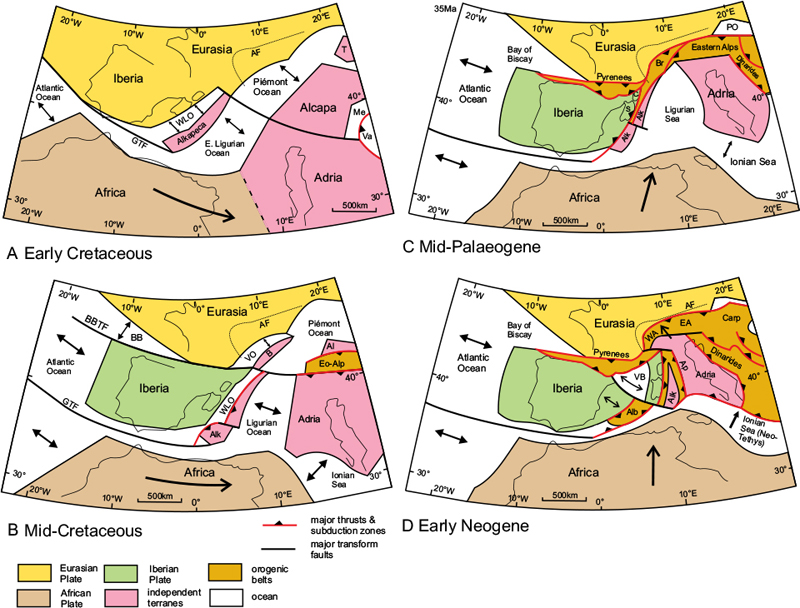
Figure 4.6 Plate tectonics of the Western Mediterranean. Interpretation of the sequence of movements of plates and terranes in the western and central Mediterranean from the beginning of the Cretaceous to the Early Neogene. AF, Alpine Front; Al, Alcapa; Alb, Alborán complex; Alk, Alkapeca; Ap, Apennines; B, Briançonnais Terrane; BB, Bay of Biscay; BBTF, Bay of Biscay Transform Fault; Br, Briançonnais Zone; Carp, Carpathians; EA, Eastern Alps; Eo-Alp, Eo-Alpine Orogen; GTF, Gibraltar Transform Fault; PO, Piémont Ocean; T, Tisza; Va, Vardar Ocean; VB, Valencia Basin; VO, Valais Ocean; WA, Western Alps; WLO, West Ligurian Ocean. Note that the Alpine belts of North Africa are not shown. After Handy et al., 2010.
During the Palaeogene Period, the further extension of the Atlantic Ocean spreading axis between Greenland and Norway caused the convergence direction between Africa and Eurasia to change again, to a north-northeasterly direction (Fig. 4.6C). This caused collisional belts to be formed in the Pyrenees and along an arcuate belt from Corsica, along the southeastern coast of what is now France, into the Alps.
By the early Neogene Period, this convergent movement had changed to northwards, resulting in the formation of all the main mountain chains in the Western Mediterranean sector including the Alps, Apennines, Dinarides and Carpathians, partly as a result of the northwards movement of Adria and partly due to extensional movements in the Valencia Basin (Fig. 4.6D). The latter is a back-arc basin formed on the upper plate of a subduction zone situated along the eastern side of Alkapeca causing a block of crust consisting of Corsica-Sardinia and the northern part of Alkapeca to collide with Adria to form the Apennines.
The southern part of Alkapeca remained in the area now occupied by the Balearic Islands, and later in the Neogene collided with Iberia in the north to form the Alborán complex and the Kabylides in Algeria in the south. During the later part of the Miocene, the Alborán complex moved south-westwards and was squeezed by the convergence between Iberia and Africa to form the Betic Cordillera.
The extensional movements in the Balearic and Alborán Sea basins are part of the eastwards migration of the subduction zone attributed to trench roll-back, and is discussed further in the next chapter.
The Pyrenees
There are four Alpine mountain belts in the Iberian Peninsula: the Pyrenees, the Betic Cordillera, the Iberian Cordillera and the Catalan Coastal Ranges (Figs 4.2, 4.3). Of these, the Pyrenean belt is the most dramatic and best studied.
The Pyrenean Mountains, named after the mythical Celtic Princess Pyrene, form a natural barrier between France and Spain, extending westwards from the Mediterranean coast at Cap de Creus, near Perpignan, to the Bay of Biscay at San Sebastiån, a distance of 490km. However, the belt of Alpine deformation continues westwards, partly offshore, along the northern coast of Spain, to the western end of the Iberian Peninsula (see Fig. 4.7).
The main part of the belt, forming the Pyrenees, is between 100km and 150km across. The mountain range rises towards the east, and contains many high peaks including Pico de Aneto, the highest, at 3404m and Monte Perdido, 3355m. The highest summits are situated within the high mountain ridge of the Maladeta Massif, composed largely of granite (Fig. 4.8).
Tectonic setting
The Pyrenean belt originated in the Triassic Period as a major rift zone, the Bay of Biscay Rift, separating the Palaeozoic Iberian Massif from the rest of Europe (see Fig. 4.4A). This zone became a transform fault in the Jurassic Period, parallel to the important transform fault through the Straits of Gibraltar separating Iberia from Africa (Fig. 4.6B). During the Cretaceous, as the Atlantic opened further and spread north (Fig. 4.6C), the Bay of Biscay opened up between the marginal faults of the rift zone with the development of oceanic crust within the rift. This movement was associated with the counter-clockwise rotation of both Iberia and Africa relative to Eurasia.
Figure 4.6 shows how, between the mid-Jurassic and late Cretaceous, Iberia moved southeast parallel to the Bay of Biscay Transform Fault, which led to convergence and thrusting along the eastern segment of the belt. During the same period, Africa had moved by a much greater amount southeastwards, parallel to the Straits of Gibraltar Transform Fault, to a position close to its present one. By the end of the Palaeogene, the movement paths of both Africa and Iberia relative to Eurasia had changed to a more northerly direction, and the Bay of Biscay had begun to close due to convergence between Africa and Eurasia, causing compression along the length of the belt. Because the convergence is slightly oblique to the trend of the belt, the amount of tectonic shortening varies along its length, being much greater in the east.
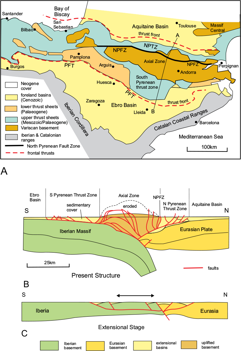
The Pyrenees is a superficially symmetrical orogenic belt in the sense that it is bordered by forelands to both north and south, and thrusting is directed northwards in the north and southwards in the south, but it is asymmetric in detail, since the bulk of the thrust units are directed southwards. Five main tectonic units are recognised, from north to south: the Aquitaine Basin; the North Pyrenean Thrust Zone; the Axial Zone; the South Pyrenean Thrust Zone and the Ebro Basin (Fig. 4.7). The deep structure of the belt has been the subject of a detailed geophysical survey – part of a series termed ECORS (étude continentale et oceanique par reflexion et refraction seismique) conducted by an international team, which has resulted in the reconstruction shown in Figure 4.7B.
The nature and arrangement of tectonic units in the Pyrenees is inherited from its origin as an extensional rift zone (Fig. 4.7C); many of the major thrusts are ‘normal faults’ (i.e. they were formed by extension), which have been re-activated as ‘reverse faults’ (i.e. by compression) and the thrust sheets originated as exten-sional basins in the Cretaceous. This type of behaviour, where the movement on a fault reverses from exten-sional to compressional, is known as ‘inversion’ and is a common feature of orogenic belts. The predominance of southward-directed thrust sheets along the southern side of the orogenic belt reflects the original location of these basins south of the Europe–Iberia boundary.
Figure 4.7 The Pyrenean Orogenic Belt. A. Simplified tectonic map showing the main tectonic zones. NPFZ, North Pyrenean Fault Zone; NPTZ, North Pyrenean Thrust Zone; PFT, Pyrenean Frontal Thrust. B. Simplified cross-section along the line A–B of Figure A to illustrate the crustal structure; note the complex antiformal thrust stack in the Axial Zone. C. Reconstruction of the late Mesozoic extensional stage; note (1) the series of half-grabens and (2) the crustal thinning resulting in a deep fault breaking through the crust; this will become the subsequent plate boundary. After Puigdefàbregas et al., 1992.
The Aquitaine Basin
This basin encompasses a large area of southern France, bounded in the north by the Armorican Massif, in the east by the Massif Central, and in the south by the Pyrenean Mountains (Figs 4.2, 4.7). Most of this area was a continental platform throughout the Mesozoic and Cenozoic Eras and acquired a thin sedimentary cover commencing in the Triassic Period, which continued through the Jurassic. By the late Cretaceous Period, while typical shelf sedimentation continued in the north of the main basin, local small sedimentary foreland basins developed close to what became the North Pyrenean Thrust, into which up to 11km of marine sediments were shed from the rising mountain range. Note that this is a cumulative figure obtained by adding thicknesses in several different places; no individual basin would be as deep as this. By the late Palaeogene Period, these basins had filled up, the sea retreated, and the Pyrenean fold-thrust belt began to advance across the foreland basins. Sedimentary sequences of this type are found throughout the Alpine–Himalayan belt and were recognised quite early in the history of geological investigation of the Alps as a type of tectonic unit integral to the orogenic process – thus ‘synorogenic’ – and the sediments characteristic of these units were named ‘flysch’.

Figure 4.8 The Maladeta Massif, Central Pyrenees. Taken from the Vall de Cregeuna, Posets. © Shutterstock, by patjo.
The North Pyrenean Thrust Zone
This zone is only about 10km wide over most of its length but broadens out to 40km in the west (Fig. 4.7). The central and western parts of the thrust zone contain outcrops of uplifted Palaeozoic basement, but most of the zone is composed of strongly folded Jurassic and Cretaceous platform sediments. By the later Cretaceous Period, an east–west extensional basin had developed within the zone, which received a thick sequence of flysch sediments. In the northern part of the zone, the Mesozoic sedimentary cover, including the flysch sequence, became detached from the basement uplifts and transported northwards on thrust sheets along a weak bed of Triassic evaporites (salt and gypsum). The thrust sheets extend across the southern margin of the Aquitaine Basin; the northern thrust front lies a short distance inside the Basin.
The southern part of the thrust zone, close to the North Pyrenean Fault, consists mainly of metamorphic rocks and contains many outcrops of ultramafic igneous rocks thought to have been derived from the upper mantle. The thrust zone is bounded on its southern side by the steeply-dipping North Pyrenean Fault Zone, which is regarded as the plate boundary between Iberia and the Eurasian Plate (Fig. 4.7). The zone becomes more diffuse north of Pamplona and its continuation westwards is uncertain.
The Axial Zone
This zone contains all the high mountains of the Pyrenean chain, including the Maladeta Massif, the central part of which is composed of a large granite intrusion. Much of the massif is over 3000m in height, and corresponds to a zone of thickened crust (Fig. 4.7B). This thickening has been achieved by a compressive shortening of approximately 20 per cent, equating to between 10km and 20km of horizontal displacement, but this reduces westwards as the zone becomes less pronounced. The zone extends from the Mediterranean coast south of Perpignan westwards for over 300km before being concealed by Mesozoic cover east of Pamplona. It is bounded on its northern side by the steeply-dipping reverse faults of the North Pyrenean Fault Zone, and on its southern side by steeply-dipping reverse faults that have back-thrust the overlying Mesozoic cover (Fig. 4.7B).
The rocks of the Axial Zone belong to the Palaeozoic basement, and are arranged in a series of thrust sheets. These have become arched up, and their boundary thrusts steepened due to the effect of the progressive forwards propagation of the basal thrust, as illustrated in Figure 4.9.
The South Pyrenean Thrust Zone
This is a southerly-directed fold-thrust belt, which is about 75km wide in the central part of the zone but decreases in width to both east and west (Fig. 4.7); its southern boundary is defined by the Pyrenean Frontal Thrust. There is considerable variation along the length of the zone: in the west, around Pamplona and Arguis, it is dominated at outcrop by thrust sheets consisting of deposits of Palaeogene age, originally laid down in a Cretaceous extensional basin like the one in the northern thrust zone. In the central part of the southern zone, thrust sheets containing mainly Mesozoic strata predominate, while in the eastern segment, there is a narrow Palaeogene basin in the northern part of the zone, but south of this there is a broad belt of thrust sheets containing platform sediments of the Ebro Basin, described below.
The earliest thrusts in the zone developed during the later Cretaceous Period by the reactivation of the normal faults bounding the early Cretaceous extensional basins. The thrusting then spread southwards during the Palaeogene Period until thrust movements ended around the end of the Palaeogene. At each successive stage in the deformation, as the thrust front migrated southwards, a depositional basin receiving molasse-type non-marine sediments formed in front of the rising mountains, but these were successively over-ridden as the thrusting progressed southwards. This process, illustrated in Figures 4.9A and B, was driven by the growth of the thrust stack and the consequent crustal thickening and elevation of the Axial Zone. Not all of the shortening was achieved by southward-directed thrusts; as compression at the margins of the Axial Zone increased, a northward-directed reverse fault (i.e. a ‘back-thrust’) developed along its southern boundary (Fig. 4.9). The thrust sheets rested on a bed of evaporite, which formed a weak layer over which they were transported.
The Ebro Basin
This basin occupies a roughly triangular area bounded on the north by the Pyrenean Frontal Thrust, in the southwest by the mountains of the Iberian Cordillera, and in the east by the Catalan Coastal Ranges (Figs 4.2, 4.9). The basin is highly asymmetric; the northern side is a foreland basin, and contains a thick sequence of clastic sediments. It is over-ridden by the South Pyrenean thrust sheets as described above; however, the remainder of the basin is an undeformed platform consisting of the Iberian Palaeozoic basement with a thin cover of Palaeogene and Neogene sediments. Marine deposits in the early- to mid-Palaeogene Period were succeeded by evaporites during the mid-Palaeogene, but from the late Palaeogene through the Neogene Period, the basin was surrounded by mountains from which it received non-marine (continental) clastic molasse deposits.
Minor Alpine mountain ranges of Iberia
The Iberian Cordillera
This rather subdued mountain chain extends from the western end of the Pyrenees in the north to the eastern end of the Betic Cordillera in the south (see Figs 4.2, 4.3), a distance of over 300km, and is about 250km across at its widest. It consists of part of the stable Iberian Massif, which has been affected by narrow zones of localised compression caused by thrusts and reverse faults, separated by wide zones of relatively undisturbed stable platform. The origin of the Iberian Cordillera probably lay in the set of extensional rifts and normal faults that existed during the Jurassic Period. The mid-Palaeogene convergent movement that was responsible for the Pyrenees also caused compression across the Iberian Cordillera by inverting the movements on the pre-existing normal faults.
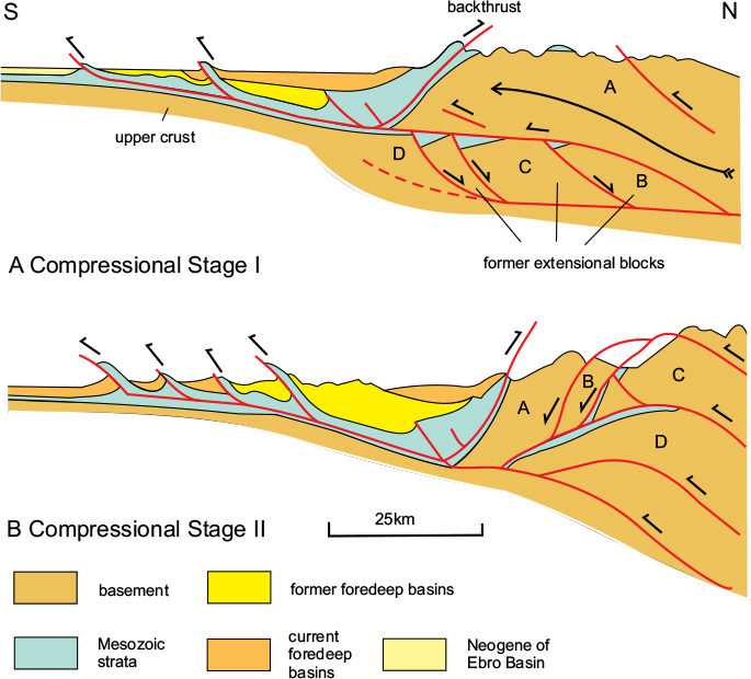
Figure 4.9 Evolution of thrusting in the Pyrenees. A. Compressional stage I (mid-Palaeogene): a basement block from the interior of the developing orogen has over-ridden the southern platform, pushing its cover before it; thrusts propagate southwards and where they break to the surface, elevations are formed, which shed clastic sediments into new foredeep basins. B. Compressional stage II (end-Palaeogene): a series of former extensional basement blocks have been successively overthrust towards the south, forming the antiformal thrust stack, thickening the crust and elevating the surface; the thrust front has propagated further into the foreland forming a series of new foredeep basins. The vertical scale has been exaggerated. The structure approximates to that of the cross-section A–B of Figure 4.7A. After Puigdefàbregas et al., 1992.
The Catalan Coastal Ranges
This narrow mountain belt, only about 50km across, extends along the southeastern coast of the Iberian Peninsula, and forms the southeastern margin of the Ebro Basin from the Iberian Cordillera in the southwest to the Pyrenees in the northeast (Fig. 4.7). It was formed by a series of reverse faults and associated folds, similar to those of the Iberian Cordillera, but which trend NE–SW, at a high angle to both the Iberian and Pyrenean structures. The Catalonian structures appear to be later than the others, and formed at a time when the convergence direction between Africa and Iberia had rotated into a more northerly orientation in the late Palaeogene. By the early Neogene, this coastal belt was affected by crustal extension related to the opening of the Valencia Basin, as discussed below (see Fig. 4.6D).
The Betic Cordillera and the Rif–Tell belt
The Betic Cordillera (Figs 4.2, 4.10) consists of a number of separate mountain ranges, situated along the southern coast of Spain, at the western end of the Mediterranean, between western Andalucia and Valencia. The cordillera as a whole is 500km long and up to 150km across, and is bounded in the north by the basin of the Guadalquivir River. The most impressive of the ranges is the Sierra Nevada (Fig. 4.11), which contains mainland Spain’s highest mountain, Mulhacem, at 3478m, situated in the Sierra Nevada National Park.
Figure 4.10 The western Betic Cordillera. After Alonso-Chaves et al., 2004; and Castro et al., 2009.
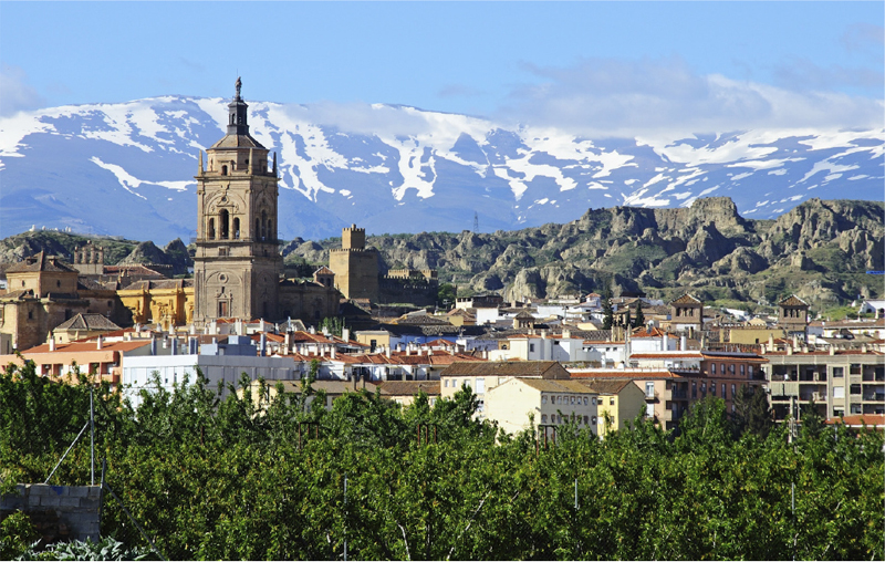
Figure 4.11 The Sierra Nevada from Guadix. © Shutterstock, by Arena Photo UK.
At its western extremity, the mountain belt turns through an angle of 150° around the Straits of Gibraltar into the Rif–Tell belt of Morocco. The eastern end of the chain is submerged beneath the Mediterranean Sea but reappears in the Balearic Islands. The Betic Cordillera is divided into three main tectonic domains: the External Region, the Flysch Basin and the Alborán, or internal, Zone.
The External Region
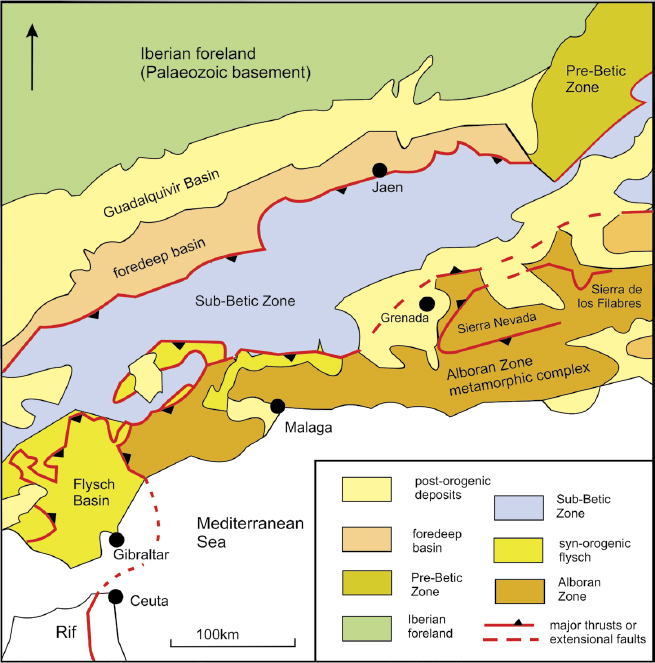
The External Region corresponds to the passive continental margin of the Iberian Peninsula, in the south-western part of the Eurasian Plate, and is equivalent to the foreland of the Alpine orogenic belt. It consists of a basement of deformed and metamorphosed Palaeozoic rocks with an unconformable cover of Mesozoic sediments typical of the continental platform. This sedimentary cover thins southwards towards the original passive continental margin and now forms a typical foreland fold-thrust belt in which the Mesozoic strata have been overthrust towards the northwest in a number of thrust sheets. Along the northern margin of the external zone, the Mesozoic platform sequence is overlain by Neogene sediments of the Guadalquivir Basin, the southeastern part of which consists of a foredeep basin, containing molasse deposits shed from the rising orogenic belt.
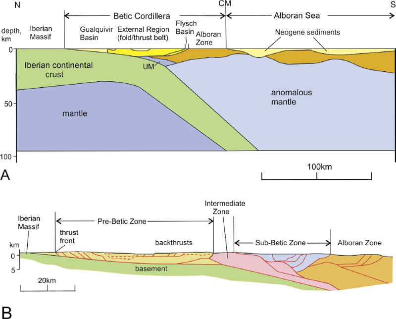
Figure 4.12 Large-scale structure of the Betic orogen. A. Interpretation based on geophysical data. Note: 1, the Iberian Plate descends southwards beneath the Alborán Sea; 2, the thinned and detached continental crust on the upper plate. CM, continental margin; UM, ultramafic body. B. Simplified NW–SE cross-section through the eastern part of the Cordillera, across the Sierra de Segura to the coast near Cartagena, showing the main tectonic zones and principal structures. Some faults are shown in red. A, after Azañon et al., 2002 and Morales et al., 1999; B, after Banks & Warburton, 1991.
The main part of the External Region, south of the thrust front, has been subdivided into the Pre-Betic, Intermediate and Sub-Betic zones (Figs 4.10, 4.12). The Pre-Betic Zone consists of lightly deformed Triassic to early Neogene shallow-marine carbonate deposits of the foreland, which have not been displaced far from their original site of deposition; such tectonic units are known as ‘autochthonous’. However, in the Sub-Betic Zone, the Mesozoic sequence has been thrust northwards over the Pre-Betic Zone, and has lost contact with its original basement; such thrust units are known as ‘allochthonous’. This zone occupies a wide area between the thrust front and the margin of the Alborán Zone in the area represented by Figure 4.12, having completely over-ridden the underlying zones in the southwestern and central sectors of the External Domain. The Intermediate Zone, situated between the Pre-Betic and Sub-Betic zones, contains material that originated in a late Jurassic to early Cretaceous sedimentary basin; it is not exposed in the area of Figure 4.10 but occupies a large part of the cross-section of Figure 4.12B.
The Flysch Basin
This is a complex of thrust slices containing clastic sediments of Cretaceous to Paleogene age deposited in a marine basin. It only appears at the surface in the southwestern part of the belt, northwest of Malaga and around Gibraltar (Fig. 4.10). The base of the flysch sequence in the Rif belt rests on basalt volcanics of the oceanic crust.
The Alborán Zone
This tectonic zone represents the metamorphic core complex, originally situated in the central part of the orogenic belt. It has been subdivided into three tectonic complexes, each of which contains a number of thrust slices: the Nevado-Filabride, Alpujarride and Malaguide complexes. These units have been arched up into a large, elongate dome structure that exposes the structurally lowest complex, the Nevado-Filabride, in its core. It is this unit that forms the high mountains of the Sierra Nevada within the Sierra Nevada National Park (Fig. 4.11) and also the Sierra Filabride to the east. It consists of metamorphosed rocks, mainly schists and gneisses, belonging to the Palaeozoic basement together with a thin Mesozoic to early Palaeogene cover.
The Nevado-Filabride Complex is flanked on its north and south sides by the structurally higher thrust sheets of the Alpujarride Complex, which consists of Palaeozoic and Permo-Triassic metasediments, including prominent marbles, and also contains thrust slices of peridotite derived from the upper mantle.
The structurally highest thrust units of the zone belong to the Malaguide Complex, exposed around the city of Malaga, and contain metamorphosed Palaeozoic basement rocks together with unmetamorphosed Mesozoic to Palaeogene carbonates and Neogene clastic deposits.
The boundaries between the thrust complexes of the Alborán Zone and between many of the individual thrust units within each of the complexes are now represented by extensional shear zones or faults, many of which originated as thrusts. Some of these extensional faults in the central part of the orogen are overlain by Neogene sedimentary basins, implying that the extensional movements also took place during the Palaeogene or early Neogene Periods and may have been partly contemporaneous with the compressional movements in the external zone.
The present complex arrangement of the Alborán structures is due to phases of N–S to NW–SE movements involving both compression and extension.
Tectonic history
The early tectonic history of the Betic region was dominated by extension in the Jurassic Period, which resulted in N–S to NE–SW-oriented rifts. These became filled with sediments of mostly Cretaceous age, and subsequently became incorporated in the Intermediate Zone of the fold-thrust belt.
The structural evidence from the thrust structures in the Alborán Domain indicates that these tectonic units were initially emplaced westwards, from the original interior of the orogenic belt that then lay to the east, in an area presently lying within the Western Mediterranean Sea (see Fig. 4.6D). The structures associated with the Alpine metamorphism of the Alborán rocks have been dated as early Miocene, but an older, Eocene, metamorphic event is also recorded, which must indicate the date at which the lower units of the complex became buried to some depth.
The main compressional event resulting in the foreland fold-thrust belt of the External Domain took place during the early Miocene Epoch, around 20Ma ago, and was a consequence of the change in convergence direction between Africa and Iberia shown in Figure 4.6. The thrust and fold structures of the Flysch, Pre-Betic and Sub-Betic zones indicate that these movements were directed towards the north and northwest in the outer parts of the fold-thrust belt, but also that back-thrust movements in the inner part of the belt were directed towards the interior of the belt, as shown in Figure 4.12B. There has also been significant extensional faulting, especially in the Alborán Domain, which seems to have been, at least in part, contemporaneous with the compressional movements in the fold-thrust belt.
The early Miocene structures are affected by folding and reverse (i.e. compressional) faulting of late Miocene age, indicating a phase of NW–SE compression that was also responsible for the arching up of the Alborán units.
The Gibraltar Arc and the Rif–Tell belt
The Betic belt continues around the Gibraltar Arc, curving through 150° into the Rif–Tell belt of North Africa (see Fig. 4.3). The latter belt is a mirror image of the Betic Cordillera: the metamorphic core complex, continuation of the Alborán Domain, is exposed along the coast, but most of the belt lies within the External Region, where the structures are directed outwards towards the south. The Rif chain, lying entirely within Morocco, curves in an arc along the shore of the Mediterranean Sea from Tangier, at the Straits of Gibraltar in the west, to the Algerian border in the east, a distance of about 290km. Compared to the more impressive Atlas Mountains to the south, the Rif is not particularly high – the highest peak being Monte Tidirhine, at 2456m. The belt continues further east as the Tell range, which extends for 1500km along the northern coast of Algeria, finally merging with the Atlas belt in northern Tunisia. The western closure of the Gibraltar Arc is hidden beneath the sea but can be clearly traced as a submerged ridge, between 300m and 900m in depth, linking Gibraltar in the north with Ceuta in the south.
Tectonic interpretation of the Betic–Rif-Tell belt
The Pyrenees belt, which was discussed earlier, has a relatively simple overall structure caused by extension followed by compression – both directed roughly at right angles to the trend of the fold belt. In comparison, the Betic Cordillera is much more complex, and it is clear that for orogens of this type, the plate-tectonic model offers only a partial explanation. Two other processes have to be considered in explaining them: the effects of gravitational imbalances caused by the over-thickening of the crust, and the relative movements of blocks of crust that are smaller in scale than the main plates, but which interact with them. This latter process will become evident in considering the Alps.
During the early stages of the Betic–Rif–Tell history, the contiguous regions of Africa, Iberia and North America were part of a continuous continental platform, whose passive margin lay far to the east at the western margin of the Tethys Ocean (see Fig. 4.4A). During the Triassic and Jurassic Periods, this platform was cut by a number of extensional rifts, which became filled with sediments during the Jurassic and Cretaceous Periods, and some of which expanded to become ocean basins. One of these oceanic basins became what is known as the Piémont–Liguria Ocean, which lay east of Iberia, roughly in the position now occupied by the Balearic Islands; another became the mid-Atlantic Ocean. At this time the southern margin of Iberia was a transform fault that ran through the Straits of Gibraltar as shown in Figure 4.6.
The tectonic situation changed in the Paleogene when the African Plate began to converge with Eurasia (see Fig. 4.6C, D). Compression caused by this change in relative motion resulted in the stacking of thrust slices, giving rise to extreme crustal thickening and the development of high-pressure metamorphism in the lowest units of the Alborán Domain, which at that time formed part of the Iberian platform lying east of the present southeast coast of Spain.
As the convergence between Africa and Iberia continued through the Neogene, the Alborán complexes were emplaced onto the Iberian platform and the Iberian lithosphere was under-thrust beneath the Alborán units, resulting in the development of the fold-thrust belt of the External Region. At the same time, the Rif–Tell belt was forming along the northern margin of Africa as the Alborán Zone was squeezed by the convergence of Africa and Iberia, resulting in the internal units being emplaced southwards on the opposite side of the orogen.
The original tectonic sequence has been disrupted by extensional movements, which have resulted in gravitational sliding of the uppermost units of the thrust stack. These seem to have been related to later Neogene N–S compression, which resulted in the arching up and exposure of the lower units of the Nevado-Filabride Complex.
It has been estimated that about 250km of north–south crustal shortening took place across the Betic belt during the late Palaeogene to early Neogene phase of collision between the African Plate and Iberia. This was followed by around 50km of oblique convergence in a NW–SE direction in the later Neogene.
Considering the Betic–Rif–Tell belt as a whole, the most obviously strange feature is the gap in the centre corresponding to the Alborán Sea. The section in Figure 4.12A shows that this is partly due to a thinning of the continental crust and partly to complete rifting leading to the development of a section of oceanic crust. So what should have been the thickest and most elevated sector of the orogenic belt has collapsed. These movements also resulted in pronounced extension within the Betic belt. There have been differing views as to the reason for this Neogene extension, but it is generally attributed to processes taking place within the mantle, and correlated with the gradual withdrawal eastwards of the subduction zone at the margin of the Neo-Tethys Ocean, discussed further in chapter 5. According to this interpretation, the Alborán Sea extensional region is a back-arc basin situated on the upper plate of a subduction zone that is retreating eastwards due to the process of ‘slab roll-back’ (see Fig. 3.12). Because the Alborán Basin represents an early stage of this process, there is little direct evidence of it here, but further east, in the Calabrian Arc where the subduction zone is situated now, there is clear evidence, which will be discussed in chapter 5.
During the later Miocene, the Alborán core complex was squeezed westwards into the Atlantic to form the Gibraltar Arc, and eastwards into the Mediterranean by the continuing convergence between the African and Eurasian plates (Fig. 4.13).
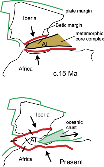
Figure 4.13 The Gibraltar Arc. Neogene NNW–SSE convergence between Iberia and Africa caused crustal thickening of the Alborán core complex, resulting in outward-directed thrusting around its perimeter (the Gibraltar Arc) followed by extensional collapse and eastwards escape of the central part. Al, Alborán region.
The Atlas Mountains
The Atlas Mountains consist of several distinct mountain chains stretching from the Atlantic coast of Morocco to the Mediterranean coast in Northern Tunisia, a distance of 2500km (Figs 4.2, 4.3). The mountain belt forms a barrier to the Sahara Desert to the south. The westernmost chain, 700km long, is known as the High Atlas and contains the highest peak in the range, Jebel Toubkal 4167m (Fig. 4.14). East of this is the Saharan Atlas, which extends for a further 1800km through Algeria in a northeasterly direction towards the Tunisian border where it meets the Tell Atlas.
Unlike the Betic–Rif–Tell belt, the Atlas chains are an orogenic belt that is entirely intra-continental in origin; there is no record of the subduction of oceanic crust, and the mountain chains have resulted from the compression and uplift of what was an extensional rift basin formed during the Mesozoic Era. The extensional faults that formed the boundaries of the rift valley became re-activated as reverse faults or thrusts during the late Palaeogene to early Neogene compression caused by the convergence between the African and Eurasian Plates. The belt as a whole is symmetrical, in the sense that the thrusts and overfolds at the margins of the belt are directed outwards – to the north along the northern boundary and to the south along the southern.
The structural evidence from the faults and folds along the marginal zones of the orogenic belt indicates that the direction of compression was oblique, causing a mixture of thrusts with a north–south movement direction and dextral (right-lateral) strike-slip faults. This type of arrangement is known as ‘strain partitioning’ and indicates that the convergence direction, at least in its latter stages, must have been oblique to the trend of the fold belt – in this case NW–SE rather than north–south, similar to the later convergence direction recorded in the case of the Betic belt.

Figure 4.14 The High Atlas range. Jebel Toubkal National Park, Morocco. Shutterstock©John Copland.