Plate-tectonic framework
It is not possible to give a satisfactory explanation of the locations and origins of the Earth’s great mountain ranges without some understanding of the processes that control the movements of the Earth’s crust. The last chapter explored how ideas about these processes evolved gradually until, by the 1960s, it became generally accepted among geologists that the movements of the continents were controlled by lateral movements of the ocean crust, which themselves were propelled by solid-flow convection in the Earth’s mantle. All that was needed was a conceptual model that explained how this process worked in detail – a model that came to be known as plate tectonics and which revolutionised the earth sciences because it provided an explanation for so much that had hitherto been unexplained or insufficiently understood.
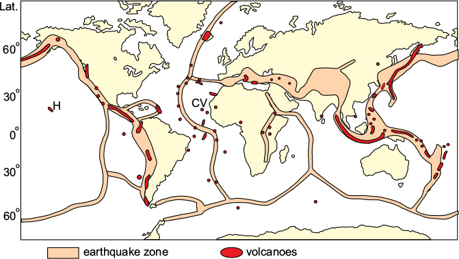
The plate-tectonic theory evolved gradually out of the sea-floor spreading concept described in the previous chapter, thanks to the insights of several influential figures. Among these was Tuzo Wilson, of Toronto University, who recognised the significance of the linear zones of volcanoes and earthquakes that delineate a worldwide, tectonically active, network (Fig. 3.1). This map shows that the sites of the major earthquakes follow a network of narrow zones along the crests of the ocean ridges and within broader and less well-defined zones along the island-arc–trench system of the Western Pacific and Indian oceans, and the orogenic belts of the continents (compare Fig. 2.8). The great majority of active volcanoes also occur within the same belts, although a few occur within the ocean basins, such as the Hawaian islands in the Pacific and the Cape Verde in the Atlantic.
Wilson realised that this concentration of tectonic activity must define the zones where crustal movements were taking place at present, and that the network of zones must therefore mark the boundaries of relatively stable ‘blocks’ of crust. The term ‘block’ was subsequently replaced by the now familiar term plate. The margins of these stable blocks could thus be traced by following the earthquake zones.
Transform faults
In a ground-breaking paper in 1965, Wilson pointed out that the numerous faults that appeared to offset the ridge axes and the trenches were also delineated by earthquakes, and were themselves part of the boundary of the stable blocks. He realised that these faults effectively changed the sense of movement across the boundary from, say, divergent across an ocean ridge to one that was parallel to the fault. Such faults were given the name transform faults since they ‘transformed’ the sense of motion along the boundary of a block.

Figure 3.1 Global network of earthquakes and volcanoes. The earthquake zones follow the tectonically active crests of the ocean ridges, the island arcs of the western Pacific, and the Alpine–Himalayan and American Cordilleran mountain belts. The volcanoes are mostly concentrated along the same zones but some (e.g. Hawaii, H and Cape Verde, CV) also occur within the ocean basins. After Chadwick, 1962.
Figure 3.2 Transform faults. A, plates X and Y are moving apart from a ridge, and the sense of movement along the transform fault is dextral – i.e. the opposite side is moving to the right. B, plates X and Y are moving together at a trench; the sense of movement along the fault is also dextral. C, in a wrench fault, a green band on the opposite side of the fault is moved to the left and the sense of movement on the fault is the same as the movement of the green band – i.e. sinistral.
Figure 3.2 illustrates Wilson’s concept with two examples: in A, plates X and Y are moving apart and divergent motion across the ridge is transformed to motion parallel to the fault that joins the ends of the ridge segments; in B, plates X and Y are moving together (Y is being thrust beneath X) and convergent motion across the trench is converted into motion parallel to the transform fault. Note that in both A and B, the sense of relative motion along the fault is dextral or right-lateral (i.e. for an observer standing on one side, the opposite side moves to the right). Figure 3.2C illustrates an example of a wrench fault (alternatively known as a strike-slip fault), which is a common type of fault found on land. This has apparently the same sense of displacement as the transform fault in A and B, in that the opposite side moves to the left. However here, the whole block on one side moves in the same direction and the sense of movement is sinistral, (or left-lateral). Thus an important property of a transform fault is that the apparent movement sense (in this case sinistral), had it been a wrench fault, is the opposite of the actual sense, which is dextral. So Wilson’s discovery meant that many faults, including well-known examples of important faults that had previously been classed as wrench faults for many years, such as the San Andreas Fault of California, were re-classified by him as transform faults.
The North-East Pacific
The significance of Wilson’s introduction of the transform fault is well illustrated by the North-eastern Pacific region (Fig. 3.3) Here, the western boundary of the stable American Plate can be traced as an active earthquake zone from the Middle America Trench in the south to its intersection with the East Pacific Ridge, from where it continues north-westwards as the San Andreas Transform Fault until it meets the Cascadia Trench offshore from the Cascades volcanic arc. At the northwest end of this trench, the boundary continues along the coast as another transform fault, ending at the Aleutian Trench off Northwest Alaska. Each of these transform faults ends abruptly at a trench, at which point the sense of movement changes from one that is parallel to the fault to one that is convergent across the trench.
The Cascadia Trench sector exists because of a small oceanic plate (the Juan de Fuca Plate) situated offshore from the trench and separated from the main Pacific plate by a short section of ocean ridge, the Juan de Fuca Ridge. Within the Pacific Plate itself, all the transform faults are now inactive, the only currently active sections being those offsetting the active sections of the East Pacific and Juan de Fuca ridges. The inactive transform faults, which trend approximately E–W, are parallel to the former direction of relative motion between the Pacific Plate and the old Farallon Plate, now subducted beneath North America.
The Benioff–Wadati zones
The distribution of earthquake foci can also be used to demonstrate what happens to the stable blocks where they converge, as is the case around much of the Pacific Ocean. In 1949, two seismologists, Hugo Benioff of the California Institute of Technology and Kiyoo Wadati of the Japan Meteorological Agency, independently discovered that deep-focus earthquakes along parts of the volcanic island arc–trench network fell on a plane that dipped at an angle of around 45° beneath the line of the trench, and these zones became known as Benioff or Benioff–Wadati zones (Fig. 3.4) and subsequently as subduction zones. Detailed studies of the earthquakes in these zones were thus able to define not only the direction of movement but also the angle of inclination at the earthquake focus, and confirmed Hess’s earlier suggestion of a downward movement of the oceanic crust along the trench network.
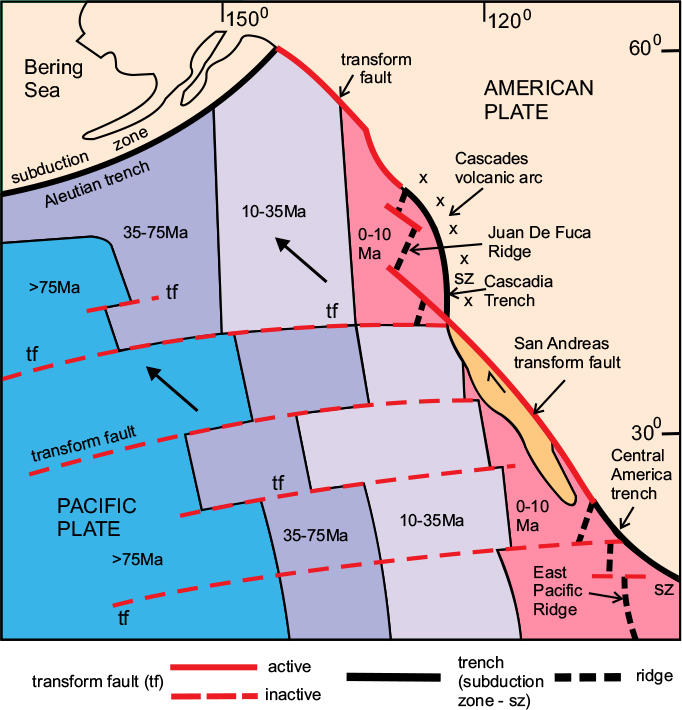
Figure 3.3 The NE Pacific. The boundary between the North American Plate and the Pacific Plate is defined by both subduction zones and transform faults (including the famous San Andreas Fault). In the Pacific plate the magnetic stripe pattern defines several dated zones which are offset by a series of transform faults. The East Pacific and Juan De Fuca ridges end against the San Andreas Fault and the movement direction changes from convergent across the subduction zones to margin-parallel along the fault. The transform faults within the Pacific are all parallel to each other and represent the direction of movement of the Pacific plate relative to the East Pacific ridge. In the north, the Pacific plate is being subducted beneath the Aleutian trench. Note that the movement direction of the Pacific plate relative to North America is NW-wards, parallel to the San Andreas Fault, and that the piece of North American continent west of that fault is also travelling NW-wards, relative to the rest of the continent. sz, subduction zone; tf, transform fault. After Larson & Pitman, 1972.
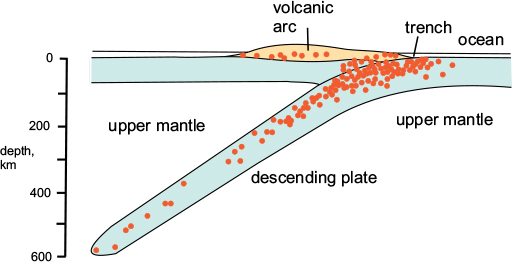
Figure 3.4 The Benioff–Wadati zone. The deep earthquakes (red dots) lie in a plane inclined beneath the volcanic island arc. Shallow earthquakes occur beneath the volcanic arc. After Uyeda, 1978.
The concept of the rigid plate
The final stage in the construction of the plate-tectonic model was based on the proposition that both continental and oceanic crust must behave in a semi-rigid manner, moving laterally as single units or blocks, and that relative movement between the blocks was concentrated at their boundaries. This insight arose mainly from the work of three scientists, Jason Morgan of Princeton, Dan McKenzie of Cambridge, and Xavier Le Pichon at Lamont Geological Observatory (now Lamont-Doherty of Columbia University), who all appear to have developed more or less the same concept independently.
The evidence for the rigidity of the blocks arose from the observation that linear features on the ocean floor, such as the faults and the striped magnetic pattern, were essentially unaffected by warping or bending such as might be expected if the ocean floor were to behave in a ‘plastic’ manner. The opposing coastlines of Africa and South-Central America still show a good fit despite having travelled away from each other for a distance of about 3000 kilometres over a period of 150 million years. Thus South America and the western half of the South Atlantic, on the one hand, and Africa and the eastern half of the South Atlantic on the other, could be considered as separate blocks, which moved as units. The Atlantic oceanic age pattern (see Fig. 2.10) confirms this.
The basic idea of the rigid plate is illustrated in Figure 3.5. Three blocks are shown: A, B and C (the term block was subsequently replaced by ‘plate’). Plates A and B are moving apart away from a ridge, which is offset by two transform faults. Because the motion of the plate must be parallel to the fault, this determines the relative movement direction of A and B. On the left side of plate B, B is descending beneath C at a trench; this process is known as subduction and the trench marks the position of the subduction zone. Again, the movement direction of plate B relative to plate C must be parallel to the transform fault that offsets the subduction zone. This direction is oblique to the previous one – in other words, the directions of relative movement of plate B are different for each boundary.
Thus an important property of plates is that they may move obliquely to a ridge or a trench but must always be parallel to any transform faults at their boundaries. At first sight, it may look as if plate B is moving in two different directions, but this is an illusion: both these movement arrows represent relative movements across different boundaries; this will be understood more easily if plate B is regarded as stationary; then plate A is moving away from it in one direction and plate C towards it in another direction. The principle that rigid plates can move obliquely to a convergent boundary was an important insight; it explained how mountain chains such as the Alps or Himalayas have curved, or even quite contorted, shapes yet are caused by the convergence of only two rigid plates whose movement directions must therefore be quite oblique to some sectors of the chains.
Lithosphere and asthenosphere
The rigid plates were conceived as having a definite thickness determined by the depth at which the material of the Earth’s mantle ceases to behave in a semi-rigid manner and becomes capable of slow plastic flow in the solid state. The mantle within this zone of flow was termed the asthenosphere and the rigid plate above it, the lithosphere; the depth of the lithosphere varies, being thinner near the warm ridge and thicker at the cooler trench, but the mean thickness is around 100km. The lithosphere consists of the crust, which is the outermost layer of the solid Earth, plus part of the mantle, which lies beneath. It is this difference in properties between the lithosphere and the asthenosphere that enables the plates to move laterally over the weaker asthenosphere.
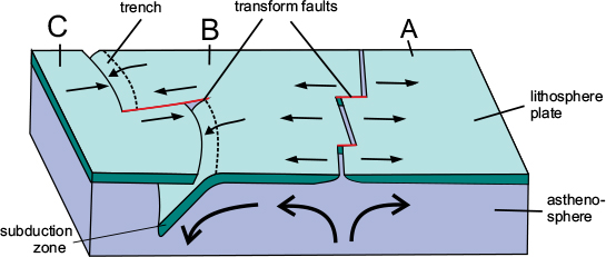
Figure 3.5 The lithosphere plate. Model showing three lithosphere plates, A, B and C. A and B are moving apart at a ridge offset by two transform faults. The movement direction is parallel to the transform faults. B is being subducted beneath C; here the movement direction is slightly oblique to the trench but parallel to the transform fault. After Isacks, Oliver & Sykes, 1968.
Tectonics on a sphere
Morgan (1968) had the idea of transferring the plate movements onto a spherical surface, having noted that transform faults, especially in the oceans, were usually curved. He divided the Earth’s crust into twenty ‘blocks’, all assumed to be perfectly rigid, whose relative motions could be described by rotations about a single axis emerging somewhere on the Earth’s surface as a ‘pole’ (Fig. 3.6). MacKenzie, along with R.L. Parker (McKenzie and Parker, 1967), applied the same reasoning to the north-eastern Pacific Plate, which was described above (see Fig. 3.3), noting that the transform faults within the plate were all parallel and slightly curved. They showed that the motion of the Pacific Plate relative to the East Pacific Ridge was westwards, parallel to these transform faults, whereas its motion relative to the North American Plate was north-westwards, parallel to the San Andreas Fault, and towards the Aleutian subduction zone (i.e. in the direction of the arrow on Fig. 3.3).
Morgan noted that the transform faults in the Central Atlantic Ocean approximated to small circles whose centre was located near the southern tip of Greenland. He also discovered that the Atlantic Ocean spreading rates varied from a maximum in the central Atlantic to a minimum north of Iceland, and concluded that both these sets of data were consistent with motion about a single axis of rotation.
The plates
Le Pichon’s contribution (Le Pichon, 1968) was to expand this data set over the whole ocean ridge network, which enabled him to simplify the global plate structure into just seven major plates: American, Eurasian, African, Indian, Australian, Antarctic and Pacific, together with a small number of minor ones (Fig. 3.7). He showed that the movements responsible for opening all the major oceans – the Atlantic, Indian, Arctic, and the North and South Pacific – could each be explained by rotations about a single axis. The poles for these axes were found by the two independent methods: first by measuring the variation in spreading rates across the ocean ridges, as determined by the ages of the magnetic stripes, and secondly by plotting the intersections of the radii of the transform faults.
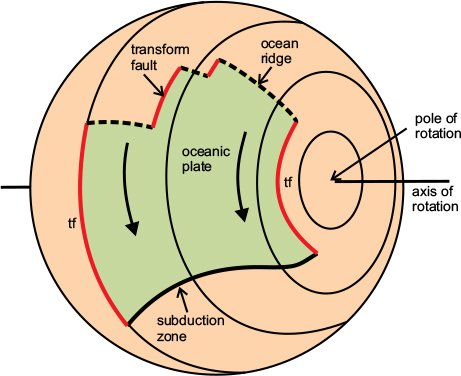
Figure 3.6 Plate tectonics on a sphere. The model illustrates the principle of plate tectonics on a spherical surface. The oceanic plate (green) is moving away from an ocean ridge and is being subducted beneath a trench. The movement direction is parallel to the transform faults that offset the ridge and also form the boundaries of the oceanic plate. The movement takes place around an axis of rotation that intersects the surface at the pole of rotation; the transform faults describe arcs of small circles about this pole. tf, transform fault. After Dewey, 1972.
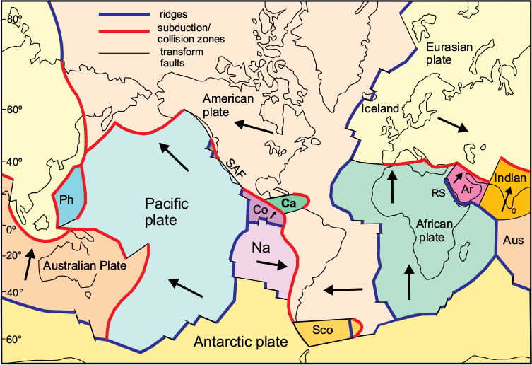
Figure 3.7 The plates and their boundaries. There are seven major plates: American, Eurasian, African, Indian, Australian, Pacific and Antarctic, together with several minor ones: Arabian (Ar), Cocos (Co), Caribbean (Ca), Nazca (Na), Philippines (Ph) and Scotia (Sco). The plates are separated by three types of boundary: constructive (ridges), destructive (trenches and collision belts) and conservative (transform faults). The arrows give the direction of motion of each plate relative to the Antarctic Plate (regarded as stationary). After Vine & Hess, 1970.
The spreading rates he measured varied from around 2cm per year (20mm/a) in the North Atlantic to more than 60mm/a in the central Pacific. By combining the data, it was possible to compute the convergence rates across the trenches: 60mm/a at the Peru Trench, 50-110mm/a across the trenches of the Western Pacific, and 56mm/a across the Himalayas.
Plate boundaries
The stable tectonic plates are completely surrounded by boundaries which, as we have seen, are of three types: ridges, trenches and faults. Since the ridges must mark the sites where new ocean crust is produced, they have become known as ‘constructive’ boundaries, and since the trenches mark the sites of destruction of ocean crust, they are termed ‘destructive’ boundaries. The transform faults correspond to zones where one plate merely slides past its neighbour without either creation or destruction of crust taking place. Consequently, because plate is ‘conserved’ at such boundaries, they are known as ‘conservative’ boundaries.
Making new plate: constructive boundaries
Figure 3.8A shows how the creation of new oceanic lithosphere takes place. Some of the new material is in the form of basaltic magma produced by melting of the upper mantle within the hot, low-density region beneath an ocean ridge. Part of this magma is injected into the crust in the form of intrusive bodies (e.g. dykes and sills), and some is poured out at the surface as lava flows. These rocks form the new oceanic crust; beneath it, new mantle lithosphere is formed by the addition of cooled material transferred from the asthenosphere. The ridge as a whole may be over 1000km wide and 2–3km above the surrounding ocean floor, but the earthquake and volcanic activity are concentrated in a narrow central rift about 100km across. The ridge is uplifted because of the presence of so much low-density material beneath it, and this results in a process of stretching that enables the new material to rise into the crust. As this new material is added, earlier-formed lithosphere moves sideways, cools, and gradually sinks to the normal level of the deep-ocean floor.
The process of plate construction can be studied on land in Iceland, which is the only exposed part of the Mid-Atlantic Ridge. Here, an average spreading rate of c.20mm/a has been achieved by the injection of a swarm of dykes along the ridge axis accompanied by a number of volcanoes, two of which (Eyjafjallajökull and Grimsvotn) have been recently active, with dramatic consequences: the 2010 Eyjafjallajökull eruption produced an enormous dust cloud that grounded much of the European air-line travel for six days. Surface measurements at three of the main volcanic centres reveal areas of uplift between 40km and 50km in diameter, which are considered to be due to the accumulation of magma at the crust–mantle boundary.
Continental rifts
Figure 3.8B shows how new crust is created on the continents. An uplifted region forms, similar to an ocean ridge, with a central rift valley into which are poured the lavas that result from the melting taking place beneath. Magma is also injected into the crust within the stretched region. If this process continues, the continental crust will separate completely and oceanic crust will form in the gap created by the extensional forces, as shown in Figure 3.8C.
The Red Sea–Gulf of Aden–African rift system (Fig. 3.9) is an example of how a new constructive plate boundary may form in continental lithosphere. The three rifts join in what is known as a ‘triple junction’; in two of the arms of the system – the Red Sea and the Gulf of Aden – new oceanic crust has formed along the centre of the rifts and joins up with the western Indian Ocean ridge. These new constructive boundaries define a separate Arabian plate, which is moving northeastwards away from Africa. Both these rifts are destined eventually to become oceans as Arabia and Africa move apart. In this way the continents of the Americas, Europe and Africa would have separated during the split-up of Pangaea.
The geological history of the African rift system is well documented; an initial doming of the surface was followed by a collapse of the rifts, accompanied by extensive vulcanicity, but unlike the other two rifts, there has been no significant separation.
Figure 3.8 Constructive plate boundaries. A. Ocean ridge: new oceanic lithosphere is created by warm mantle material rising up into a region of stretched crust where it is partly melted; some of the resulting basaltic magma rises to the surface as lava flows and some is injected into the crust as intrusions. At the same time, the lithospheric mantle grows by the addition of cooled asthenosphere. B. Continental rift: the process is the same as A, except that the magma is emplaced within and onto continental crust. The stretched region forms a prominent rift valley. Eventually as the process continues, the continental crust separates completely, and oceanic crust forms in the rift, resulting in a new ocean. C. Extension in continental rift zones: 1, large amounts of extension cause initially steep faults to rotate due to solid-state flow in the lower crust, leading to arching up of the lower crustal material and the formation of a low-angle detachment fault; 2, further stretching and thinning causes the detachment fault to cut through the crust, exposing the uppermost mantle; successor faults may displace the upper part of the detachment fault. C, after Reston, 2007.
Destructive boundaries: subduction zones
There are three types of destructive plate boundary (Fig. 3.10). The first two types follow a zone of destruction of oceanic crust and are marked at the present day by the deep-ocean trenches; the third type is a zone of collision of two continental plates, and is represented by a belt of young mountain ranges such as the Alps and the Himalayas. This third type is, in geological terms, more short-lived, since the convergent movement of continental crust will eventually cease as the two continental plates grind together and gradually come to a halt.
Figure 3.9 The Red Sea–Gulf of Aden–African Rift system. The Red Sea Rift extends from the Dead Sea Transform Fault to the northern coast of Ethiopia at the Afar Triple Junction, where it joins the Gulf of Aden Rift at the northern end of the great African Rift system. The Gulf of Aden Rift joins the NW end of the Carlsberg Ridge in the Indian Ocean to form a continuous boundary defining the western and southern margins of the Arabian Plate, which is moving NE-wards away from the African plate. Oceanic crust has formed in the Gulf of Aden and Red Sea rifts, which are moving apart. Extension has taken place across the African rifts, but no oceanic crust has formed there. The African and Gulf of Aden Rifts define the western margin of the small Somalia Sub-plate. After weebly.com/somali plate, via Wikimedia Commons.
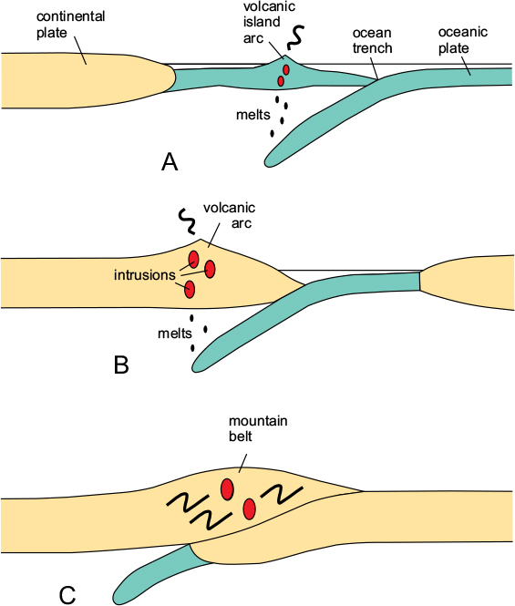
Figure 3.10 Destructive plate boundaries. A Oceanic subduction zone: oceanic lithosphere descends beneath another oceanic plate at a trench; melting occurs above the down-going slab, forming a volcanic arc on the upper plate. B Continent-margin subduction zone: oceanic lithosphere descends beneath the margin of a continental plate, forming a volcanic arc within the continental crust. C Continental collision zone: as two continents on opposing plates meet, the continent on the subducting plate is under-thrust beneath the continent on the upper plate; the continental crust is thickened and deformed and further convergence eventually stops. After Dewey & Bird, 1970.
The first two types of destructive boundary, therefore, are where oceanic crust belonging to one plate descends (is subducted) beneath another plate, which may be either oceanic or continental (Figs 3.10A, B). The lower of the two plates is always oceanic, and the deep-ocean trenches mark the subduction zones where the oceanic plates commence their descent; such zones are typically inclined beneath the upper plate at an angle that can vary from quite shallow to nearly vertical, depending on several factors, such as the rate of convergence and the age of the descending plate.
As the lower plate descends into warmer regions of the mantle, volatiles, especially water, are driven out of the crustal material and ascend into the mantle of the upper plate, part of which melts; the resulting magmas form igneous intrusions within the crust of the upper plate and feed volcanoes at the surface. Where the upper plate is oceanic, as in Figure 3.10A, the volcanoes are partly submerged and form an island arc.
In a typical island arc, the partially submerged volcanic mountain range, which may be 50 to 100 kilometres wide, is bounded on its convex side by a trench situated between 50 and 150 kilometres from the volcanic arc. Between the arc and the trench is a zone where sediments resulting from the erosion of the volcanic islands accumulate, together with volcanic material. Present-day examples of volcanic island arcs are widely distributed in the western Pacific Ocean, the eastern Indian Ocean and in the Caribbean (see Fig. 3.1).
The sequence of marine sediments formed at a subduction zone is often given the generic term ‘flysch’ and typically includes a high proportion of turbidites; these are products of the chaotic mixing of clastic material originally deposited on the continental shelf but subsequently removed and redeposited on the continental slope or in the trench by mass-flow turbidity currents triggered by sudden instabilities such as earthquakes.
The continental-margin subduction zone
This type of subduction zone, which always precedes continent–continent collision, is represented in simplified form in Figure 3.11. The descending oceanic plate causes melting to take place in the mantle wedge above the subduction zone, leading to the formation of an elevated volcanic arc on the continent of the overlying plate. Sediments and volcanic debris derived from the erosion of this volcanic massif are deposited in the offshore ocean trench. Present-day continental-margin subduction zones are situated along the Pacific margins of South and Central America.

Figure 3.11 Structure of an active continental margin. Collision is always preceded by subduction at a continental margin. Here the lower oceanic plate descends beneath the continental plate, causing melting in the asthenospheric mantle above, which in turn produces igneous intrusions in the continental crust and a volcanic arc at the surface. The continent on the lower plate will eventually meet, collide and under-thrust the upper plate, resulting in a thickening of the combined crust and intense deformation. After Dewey & Bird, 1970.
Chemical differences between magmas
The composition of the igneous rocks found within orogenic belts can be used to reconstruct the original tectonic setting in which they formed. Typical ocean-ridge basalts contain rather more silica than continental rift basalts, which are usually more alkaline. Subduction-zone magmas, although they include basalts, are typically more andesitic in composition and may also include more acid types such as rhyolite. Such magmas are often referred to as calc-alkaline and typically result in the intrusion of granites or granodiorites. Significant differences are found in the minor (or ‘trace’) elements, and so measuring the relative proportions of these is an effective way of distinguishing between igneous rocks of differing origin.
The accretionary prism
The process of subduction generally results in an accumulation of sedimentary and volcanic deposits above the trench, caused by the wedge-shaped margin of the upper plate scraping off the cover of the down-going slab, and has been likened to the action of a snow-plough (Fig. 3.11). With time, the amount of material so formed increases and extends forwards onto the leading edge of the upper plate and also backwards along the top of the lower plate. This accumulation is known as an accretionary prism and includes platform cover, trench-fill deposits and material shed from the volcanic arc. The structures of the prism are typically in the form of a fold-thrust regime directed backwards along the lower plate, but may also feature forward-directed over-folds and thrusts on the upper-plate side.
Upper-plate extension
An important feature of many subduction zones, which may seem counter-intuitive, is a region of crustal extension on the upper plate, despite the fact that the two opposing plates are converging. The extension often leads to complete severance of the continental crust and the development of a small oceanic basin, called a back-arc basin behind the volcanic arc. The cause of back-arc extension is considered to lie in a process known as trench rollback, where the position of the down-bend of the subducting slab (which determines the position of the trench) retreats backwards along the lower plate due to the downward pull of the cold, and thus heavy, slab (Fig. 3.12). Whether this takes place or not depends on a complex interplay of several factors, including the velocities of the opposing plates, the age of the descending slab, and the load of the accretionary complex on the upper slab. The process is influenced by the presence of a warmer upper mantle beneath the upper plate, caused by the release of hot material from the descending slab. There is evidence from seismic data to suggest that a piece or pieces of cold lithospheric mantle may become detached from the upper plate and sink, leaving the crust above warmer, weaker, and subject to extension.
Geological structure of mountain belts
Plate collision and mountain building
Where two continental plates collide, a zone of crustal overlap is created, which leads to a great increase in the thickness of the continental crust (see Fig. 3.10C). In some cases, crustal thicknesses of up to 80km have been recorded, e.g. in the Alps, compared with an average ‘normal’ crustal thickness of around 33km. Because continental crust is less dense and thus more buoyant than the underlying, denser, mantle, much of this extra crustal material becomes elevated to form mountain ranges with heights of up to 8km above sea level; due to the isostasy principle described in chapter 2, these mountain ranges are supported by a much greater thickness of crustal material beneath, forming a kind of mountain ‘root’.
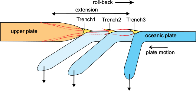
Figure 3.12 Trench roll-back. Cartoon to illustrate the roll-back mechanism. Assuming a stationary upper plate, the downward pull of the slab causes the position of the trench to migrate backwards, extending the upper plate. The dashed lines indicate the regions of upper-plate extension.
The thickened crust of the collision zone consists of rocks that have been intensely deformed by the effects of the collision: in places, great thrust sheets will have formed due to the sliding of the upper plate over the lower. As the crustal material becomes depressed into the warmer regions at depth, the folding and shearing processes caused by the collision are enhanced by the heating of the rocks caused by rising magmas. The effects of heat and pressure at depth produce changes in mineral composition and texture (i.e. metamorphism) of both sedimentary and igneous rocks.
Metamorphism
The type of metamorphism exhibited by the rocks of an orogenic belt may be used to distinguish between certain tectonic environments. Although both temperature and pressure increase with depth, their relative rates of increase differ according to the tectonic context. In the over-thickened warm crust of a collision zone, the temperature increase will have been steeper than the pressure increase, leading to a high temperature–low pressure series of metamorphic rocks ranging from greenschist facies to amphibolite facies and granulite facies as the temperature rises. In contrast, in the cooler crust of a subduction zone setting, pressure increases are dominant compared with temperature increases, resulting in a high pressure–low temperature metamorphic series typified by blueschist facies, then eclogite facies as the pressure rises.
Deformation
The style of deformation is another important indicator of the tectonic environment. Regions of the crust that have been subjected to compression exhibit contractional structures such as overthrusts and folds, which have resulted in a shortening and thickening of the crust. The upper or outer regions of a compressional regime are dominated by thrusts and the folds that are related to them, as seen, for example, in the outer zones of the Alps and the Scottish Highlands (e.g. see chapter 5, Fig. 5.5A and chapter 14, Fig. 14.8A) whereas at deeper levels where the temperature is higher, shortening is achieved by a combination of shear zones and ductile folds, as in the internal zones of the Alps and the Scottish Highlands (e.g. see chapter 5, Fig. 5.5B and chapter 14, Fig. 14.8B).
Extensional regions, on the other hand, exhibit a combination of normal faults and low-angle detachment faults (and their ductile equivalents at lower crustal levels), which result in the thinning and elongation of the crust (Fig. 3.8C). There is evidence in many mountain belts that extensional structures in the upper regions of the orogen were being formed at the same time as compressional structures were forming at the deeper levels, due to gravitational spreading of the over-thickened crust.
Foreland basins
The formation of a collisional orogenic belt places an additional weight on the lithosphere, resulting in a downward flexure that extends outwards beyond the margins of the mountain belt and produces basins on the foreland on each side of the belt. These basins gradually fill with sediment derived from the erosion of the mountain massif.
The sedimentary successions formed in this way generally show a transition from marine in the early stages to continental in the later, and are a useful indicator of the type of material being eroded at any one time from the uplifted core of the mountain belt. Sedimentary sequences of this type were termed ‘molasse’ by the early Alpine geologists and contrast with the flysch type of deposit typical of the accretionary prism in a subduction setting. A good example of the way that such basins develop and evolve with the growth of the orogenic belt is the Pyrenees belt, discussed in the following chapter (e.g. see Fig. 4.9).
An example of a collisional mountain belt
One of the best present-day examples of an active collision zone is provided by the mountain ranges of southern Asia (e.g. the Himalayan, Pamir and Tien Shan ranges) where the Indian continent has collided with, and underthrust, Asia (Fig. 3.13). The record of the gradual convergence of these two continents has been well documented from the ocean floor magnetic data (see chapter 8). Unlike constructive boundaries and transform faults, where the zones of earthquakes or volcanic activity are relatively narrow, in continental collision zones they can be over a thousand kilometres wide. The surface separating the two opposing plates may descend for long distances beneath the surface of the upper plate and may also be folded and faulted in a complex manner.
Figure 3.13 shows a wide zone of thrust slices consisting of sedimentary rocks that originally rested on the continental crust of the Indian plate, indicating that as this plate under-thrust Asia, the upper sedimentary cover, together with part of its basement, was pushed backwards and upwards to form the main Himalayan range. The overlying Asian plate, containing the remnants of the volcanic arc formed during the subduction stage, was also elevated to form the Tibetan Plateau.
Figure 3.13 Structure of a collisional mountain belt: the Himalayas. The Indian plate (left) has under-thrust the Asian plate (right). Most of the deformation has occurred in the Indian crust, which has been sliced into several large sheets separated by major thrusts. The upper levels of the thickened crust have experienced extension. The leading edge of the Asian continental crust is much less deformed and contains the evidence of a volcanic arc produced by the previous subduction phase. The sedimentary cover of the Indian Plate is shown in yellow. After Searle et al., 2011.
Typical structure of an orogenic belt
Several structural features that are found in most orogenic belts can be considered as typical: these are as follows.
1 The foreland, where the basement and sedimentary cover have not been affected by the orogenic deformation.
2 The foredeep basin, situated on the foreland but formed as part of the orogenic process, which has received sediments derived from the rising mountains of the orogenic belt; such sediments, typically non-marine, are often given the generic term ‘molasse’.
3 An external zone where the strata are folded and thrust but have not been moved far from their original position – these are said to be autochthonous. Where only the sedimentary cover has been deformed but the underlying basement has not been involved, the deformation is said to be thin-skinned.
4 A zone of more intense folding and thrusting where several thrust slices contain material derived from the interior of the orogenic belt and are ‘foreign’ to their present environment – these are said to be allochthonous.
5 An interior zone containing rocks that have been brought up from a considerable depth and have been intensely deformed and metamorphosed under high temperature and pressure; this zone is often referred to as the metamorphic core complex, and represents the central over-thickened zone of the orogenic belt.
6 A marine basin containing sediments and volcanics originally deposited on the continental slope or in an ocean trench above a subduction zone; the sediments of this zone have traditionally been termed ‘flysch’ and the marine basin a ‘flysch trough’, by the Alpine geologists who first described them.
More complex examples
The main Himalayan range is a relatively simple example of a collisional belt, involving only two opposing plates. However, many other cases involve multiple collisions, creating much more complex mountain belts: some of the Alpine chains of the Mediterranean region discussed in chapters 5 and 6 are of this type. Figure 3.14 shows how a wider collisional belt may be produced by the collision of an island arc with a continent (stages 1 and 2) followed by a further collision with a second continent. Each collision would have been preceded by subduction, leading to the creation of a more complex geological record involving a number of events with different ages and different characteristics.
Interpreting past mountain belts
Mountain belts are usually referred to by geologists as orogenic belts (from the Greek oros, mountain, and gen, produce), and the processes responsible for them are known collectively as orogeny (i.e. ‘mountain-producing’). Thus a mountain belt formed in the far distant geological past, which may have no modern topographic expression but has been deduced from geological evidence only, will always be referred to as an ‘orogenic belt’. The link between orogenic belts and plate collision is valuable in interpreting the geological record, especially in regions of old continental crust, formed in periods when no oceanic record has been preserved: all oceanic plates older than about 200Ma have been destroyed by subduction. Such belts display characteristic geological features, which can easily be identified in the rock record of former periods of Earth history.
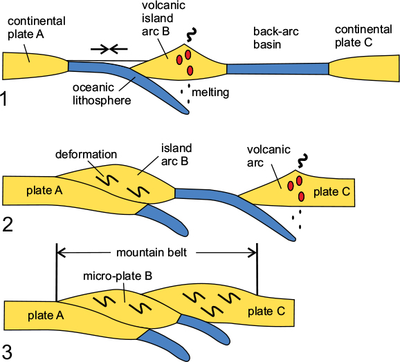
Figure 3.14 More complex collision belts. Many mountain belts are made up from the amalgamation of one or more island arcs with the main continental plates. Stage 1 shows subduction of an oceanic plate A beneath an island arc B, which is separated from continent C by a back-arc basin. In stage 2, the island arc B has collided with plate A and subduction has commenced beneath plate C, leading to the subduction of the back-arc basin. In stage 3, plate C has collided with the already-formed mountain belt created by the earlier collision to form an expanded mountain belt.
These features include:
1 highly disturbed strata (i.e. folded and faulted rocks);
2 metamorphosed deep-crustal material (evidence of uplift);
3 great thicknesses of sediments derived from the erosion of uplifted masses; and
4 igneous rocks derived from melted lower-crustal material (e.g. granite).