The Carpathians, the Balkans and Turkey
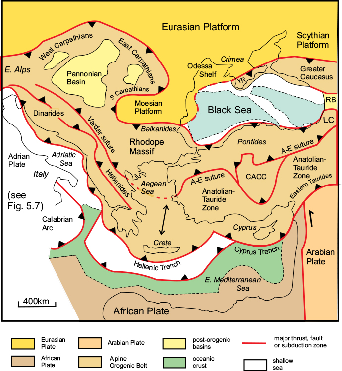
The Alpine orogenic system east of the Alps divides into two branches: the Carpathians, which describe a great arc around the Pannonian Basin, and the Dinarides, which continue down the eastern side of the Adriatic Sea through the Balkans and into Greece, where it is known as the Hellenides (Fig. 6.1; and see Fig. 5.1). The southwestern boundary of the Hellenide sector of the orogenic belt is defined by a subduction zone, along which Neo-Tethys Ocean crust of the Eastern Mediterranean is being consumed, while its northern boundary is the frontal thrust along the southern margin of the Moesian Platform. The total width of the Alpine belt here is around 1600km, but this gives a misleading impression of the amount of deformation across the belt, since a large part of it is underlain by extended crust, now largely submerged beneath the Aegean Sea, and by the Rhodope Massif, which suffered comparatively little Alpine deformation. The belt here is divided into two parts by the Vardar Suture, which marks the site of the former Neo-Tethys Ocean and separates African-derived terranes to the west and south from the Eurasian-derived Rhodope Massif.

Figure 6.1 Alpine orogenic belts of the Eastern Mediterranean and Black Sea Region. CACC, Central Anatolian Crystalline Complex; A–E, Ankara–Erzincan; LC, Lesser Caucasus; RB, Rioni Basin; YR, Yayla Range. After Okay, 2000.
South of the Black Sea, the southern, and greater, part of the Alpine belt continues through Turkey, while the northern marginal zone is submerged beneath the northwestern part of the Black Sea, to re-emerge in the Crimean Peninsula and continue eastwards as the Greater Caucasus, which extends from the northern shores of the Black Sea towards the Caspian Sea.
In Asian Turkey, the Alpine belt is divided into the complex Pontide zone in the north and the Anatolian–Tauride zone in the south, which are separated by the Ankara–Erzincan Suture, the eastwards continuation of the Vardar Suture in Greece. The Pontide Zone has Eurasian affinities similar to Dacia and the Rhodope massif, whereas the Anatolian–Tauride Terrane was derived from the African–Arabian Plate in the early Cretaceous and collided with the Pontide Zone during the Palaeogene. A large central block, known as the Central Anatolian Crystalline Complex, also of Gondwanan origin, became sandwiched between the two. The southern margin of the belt here is defined by an arcuate subduction zone situated south of Cyprus. Much of the Alpine deformation was concentrated along the contact zones between the main terranes, and in the Eastern Taurides, where the Arabian Plate converged with Laurasia. The suture zones are distinguished by extensive ophiolites. The Pontide Zone continues eastwards into the Lesser Caucasus, which is separated from the Greater Caucasus by post-orogenic sedimentary basins.
The Carpathians
The Carpathian mountain chain describes a wide semicircle around the Pannonian Basin and is divided into three branches: the Western, Eastern and Southern Carpathians (Figs 6.1, 6.2). With a total length of 1500km, it is nearly as long as the Alps, but is much less impressive in terms of height. The western end of the chain, in Slovakia, is separated from the eastern end of the Alps by the Danube valley at Bratislava, and from there it extends eastwards to form the boundary between Slovakia and Poland, where the chain is known as the Tatra Mountains. Here the Western Carpathians are at their widest and contain the highest peaks, the highest being Gerlachovský štit, at 2655m (Fig. 6.3). The Eastern Carpathians describe a wide arc from south of Krakow in southeast Poland through southwestern Ukraine into Romania, then turn abruptly west into the Southern Carpathians, otherwise known as the Transylvanian Alps. Here the chain describes an arc that is convex inwards towards the Hungarian Plain and contains several summits over 2500m. The chain ends at the Serbian border where it is cut through again by the River Danube.
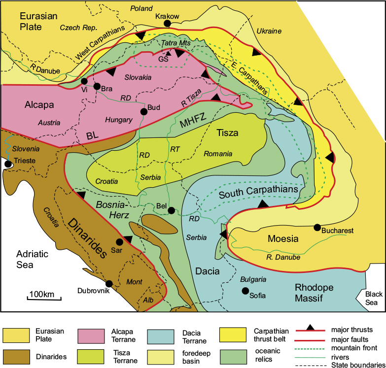
Figure 6.2 The Carpathian Region. Simplified map showing the main tectonic units. BL, Insubric–Balaton Line; MHFZ, Mid-Hungarian Fault Zone. Countries: Alb, Albania; Mont, Montenegro. Cities: Bel, Belgrade and Sar, Sarajevo; Bra, Bratislava; Bud, Budapest; Vi, Vienna. Rivers: RD, River Danube; RT, River Tisza. After Márton et al., 2007.
Tectonic structure
Each of the three branches of the Carpathians – the Western, Eastern and Southern – has the same basic structure: the outer foreland, the foredeep basin, the main Carpathian thrust belt, and the interior terranes of the Pannonian Basin (Fig. 6.2). The boundaries of the interior terranes are distinguished by zones of oceanic material, including ophiolites that mark the sites of the former ocean that separated the interior terranes from Eurasia.
The Outer Foreland
In the case of the Western and Eastern Carpathians, the foreland is part of the Eurasian Platform, and consists of Palaeozoic basement with a Mesozoic platform cover very similar to that of the Alps. The southern branch, however, is bounded by the Moesian Terrane, or Moesian Platform, which is also of Eurasian origin, but is separated from the main part of the Eurasian Plate by a narrow Triassic rift (not shown in Fig. 6.2).
The Foredeep Basin
The outermost zone of the Carpathian belt consists of a molasse-filled trough up to 100km wide, overlying the foreland margin.
The Carpathian Thrust Belt
This belt is up to 100km wide in the Eastern Carpathians but narrows to the west and south, where it is overlain by younger deposits, and is divided into outer and inner zones. The outer zone consists of a series of Palaeogene to early Neogene thin-skinned thrust nappes directed outwards towards the foreland, and containing a variety of rock types, including both sedimentary units from the Eurasian platform cover and flysch units derived from the ocean that originally separated the interior terranes from the Eurasian margin. The inner zone consists of nappes of Gondwanan basement and Mesozoic platform cover belonging to the three interior terranes of the Pannonian Basin. There is widespread evidence of calc-alkaline (andesitic) vulcanicity that was active from the Miocene to the present day. The thrusting appears to have progressed outwards towards the Eurasian foreland up to Pliocene times.

Figure 6.3 Gerlachovsky štft: highest peak in the Tatra Range, Eastern Carpathians, northern Slovenia. © Shutterstock, by Jaroslav Moravcik.
The oceanic relics
These consist of a variety of rocks, including ophiolites, considered to have been derived from an accretionary complex. They are contained within thrust slices that tectonically overlie the Thrust Belt and mark the former position of a subduction zone dipping inwards towards the Pannonian Basin. The Eurasian Foreland was thus a passive margin and the oceanic zone, site of the former Meliata–Vardar Ocean, marks the suture between it and the terranes of the interior.
The Pannonian Basin
Three separate terranes – Alcapa, Tisza and Dacia – have been identified within the basement complex of the Pannonian Basin, but are largely concealed beneath the Neogene cover. These terranes are separated by suture zones featuring ophiolites and other oceanic relics, indicating that they would have moved independently. Alcapa and Tisza were discussed previously in the context of the Alps. ‘Alcapa’, named from Alps–Carpathians–Pannonia, forms the Austro–Alpine Nappes (see Fig. 5.4) and extends eastwards into the Western Carpathians, where it forms the basement of the northern sector of the Pannonian Basin. The Tisza Terrane, named after the River Tisza that flows through the centre of the basin, lies immediately south of the Alcapa Terrane and is separated from it by the Mid-Hungarian Fault Zone, which includes the important Balaton Line. This lineament continues westwards into the Alps to join the Peri-Adriatic Line, where it marks the boundary between the Austro-Alpine Nappes (derived from Alcapa) and the Adrian Plate (see Fig. 5.4). Dacia lies south of Tisza and wraps around the Moesian promontory, continuing south-eastwards as the Rhodope Massif.
The crust underlying the Pannonian Basin experienced significant east-west stretching, crustal thinning, and extensive vulcanicity during the Neogene, resulting in the formation of the depression in which 6–8km of molasse deposits have accumulated.
Plate-tectonic history
The origin of the Carpathians is attributed to the movement of four independent terranes, Adria, Alcapa, Tisza and Dacia, the last three of which have acted as in-denters, driving in a northeasterly direction into the embayment created by the Eurasian Plate margin. Two of these terranes, Alcapa and Tisza, both of Gondwanan affinities, were discussed previously in the context of the origin of the Alps. These terranes were separated from the southern margin of Europe, while it was still attached to Gondwana, by the Piémont and Vardar oceans during the Jurassic, as shown in Figure 4.6A.
Dacia is believed to have been detached from further east along the European margin, also during the Jurassic. It forms part of an elongate strip of European basement that now curves through 180°, wrapping around the promontory of the Moesian Platform through the Balkans to the Rhodope Massif in northern Greece (Fig. 6.2).
During the Cretaceous, the northern and eastern margins of Alcapa, Tisza and Dacia were defined by subduction zones along which the Meliata–Vardar (Neo-Tethys) Ocean was consumed. This eventually resulted in Tisza being thrust over Dacia, which was in turn thrust over the European margin. Also during the Cretaceous, the large Adria Terrane moved north, collided with Alcapa, and then with the southern European margin in the late Cretaceous. The sequence of these movements is summarised in Figure 4.5.
During the Oligocene and Miocene, the subduction zone seems to have retreated eastwards due to slab roll-back into the Pannonian embayment, pulling the upper-plate Alcapa and Tisza terranes eastwards, and resulting in the Alcapa Terrane being thrust over Tisza. The position of the subduction zone was defined by an andesitic volcanic arc west of the Eastern Carpathians. The current position of the slab has been imaged by a concentration of deep-focus earthquakes in the southeastern corner of the orogenic belt, where the eastern and southern Carpathians meet.
The combined effect of the arrival of the Alcapa Terrane in the north, the eastwards push from the Adriatic Terrane in the west to form the Dinarides, and the trench roll-back in the early Neogene seems to have resulted in squeezing the other two terranes (Tisza–Dacia) into the U-shaped embayment in the European margin with the westward-projecting Moesian Platform on its southern side, and in the process has rotated and distorted them. Palaeomagnetic measurements on late Cretaceous and Palaeogene units indicate a large clockwise rotation of 120° in Tisza–Dacia from the late Palaeogene, which is consistent with the above interpretation, but also record an anti-clockwise rotation of 80° in Alcapa during the Miocene, suggesting that the clockwise rotation of Tisza–Dacia around the Moesian promontory caused a counter rotation in the adjoining Alcapa Terrane. The Alcapa–Tisza thrust boundary, originally oriented E–W to NW–SE and north-facing in the Oligocene, has thus rotated into its present WSW–ESE orientation, facing south, in the Miocene.
The Dinarides
The Dinarides, or Dinaric Alps, extend down the eastern side of the Adriatic Sea through the Balkans (Figs 6.1, 6.2) from Slovenia in the north to Albania in the south, crossing parts of Croatia, Bosnia-Herzegovina, Montenegro and Albania. The northern part of the belt runs in a NW–SE direction for about 620km, then turns southwards for a further 240km through Albania. The mountain belt then continues through Greece, where it is known as the Hellenides. The Dinarides thus form a mountain barrier on the southwestern side of the Pannonian Basin, closing off the U-shaped loop formed by the Carpathians.
The Dinaride chain is relatively narrow in the northwest and southeast, but swells out in Bosnia to around 200km in width before narrowing again through Albania, and is never especially high, averaging between 1000 and 2000 metres in elevation, with only a few peaks over 2500m. The highest peak is Mount Prokletije, at 2694m. The range is dominated by carbonate rocks, and the Dalmatian region in southern Croatia is famous for its limestone scenery; it hosts the type locality of the karst landscape (Fig. 6.4), with its carbonate-solution features such as underground drainage, caves and sinkholes.
Figure 6.4 Karst landscape of Dalmatia, Northern Dinarides. The Zrmanja River canyon, Croatia. Shutterstock©Tamisklao.
Tectonic structure
In tectonic terms, the Dinarides is an Alpine collisional belt forming the eastern margin of the Adrian Plate (Fig. 6.5A) and continues southwards into Greece as the Hellenides. The northwestern sector of the belt, which is approximately 300km across, consists of three main tectonic zones: the Adrian Platform, the Western Thrust Belt, and the Eastern Thrust Belt (Fig. 6.5B). The orogenic belt is actually much wider than the mountain range, extending westwards into the Adriatic Sea and eastwards into the Pannonian Basin. The mountain range is essentially confined to the Western Thrust Belt. The Dinarides incorporate three separate terranes, from west to east: Adria, which constitutes the western foreland; Alcapa, forming the main thrust belt; and Tisza, which is the eastern foreland to the belt but is mostly concealed beneath the sedimentary cover of the Pannonian basin.
Figure 6.5 Major tectonic features of the Dinarides. A. Map: MWZ, Miocene wrench zone; PAL, Peri-Adriatic Lineament; ft, frontal thrust of Western Thrust Belt; ZZF, Zagreb-Zemplin Fault. A-B, line of cross-section. States: Bos, Bosnia; Cro, Croatia; Mont, Montenegro. Cities: Dub, Dubrovnic; Lub, Lubljana; Pod, Podgorica; Tri, Trieste; Zag, Zagreb. B. Cross-section: AP, accretionary prism; BAB, back-arc basin; BB, Budva Basin; FB, foreland basin; PB, Pannonian Basin. After Tari, 2002.
The Eastern Thrust Belt is essentially a Mesozoic subduction belt culminating in late Cretaceous collision, while the Western Thrust Belt formed as a result of a later collision event during the Miocene.
The Adrian Platform
This zone is a foreland thrust belt involving the massive carbonate platform cover of the Adrian Plate, and includes the karst terrains referred to earlier. The thrusts are mainly directed westwards onto the Adriatic foreland, although limited back-thrusting is also evident. The zone occupies the coastal belt of Dalmatia in southwestern Croatia, including its numerous islands, and is partly submerged beneath the Adriatic Sea.
The Western Thrust Belt
Three subdivisions are recognised in this zone (Fig. 6.5B). The westernmost sub-zone consists of SW-directed folded and thrust units derived from the carbonate platform of the Adrian Terrane, known as the Dinaric Platform. The frontal thrust has over-ridden the oceanic rocks of the Budva Basin, which originally separated the Dinaric Platform from Pelagonia (Fig. 6.6). The central unit contains a thin Mesozoic sedimentary cover overlying Palaeozoic basement, which has been overthrust onto the Dinaric Platform. The eastern unit is dominated by a flysch-filled foredeep basin of Cretaceous age overlying older deeper-marine sediments.
The Eastern Thrust Belt
This zone contains a set of westwards-directed thrust nappes consisting of a Jurassic to Palaeogene sequence, including an ophiolite-bearing unit containing oceanic crustal and upper-mantle rocks. In the southern sector of the zone, the ophiolites are overlain by late Cretaceous to Palaeogene flysch interpreted as a back-arc basin deposit. The northeastern part of the zone contains a unit known as the Sava Depression, interpreted as an accretionary prism resulting from the subduction of Vardar oceanic crust beneath the Dinaric Platform. The northern margin of the zone is overlain by Neogene molasse of the Pannonian Basin.
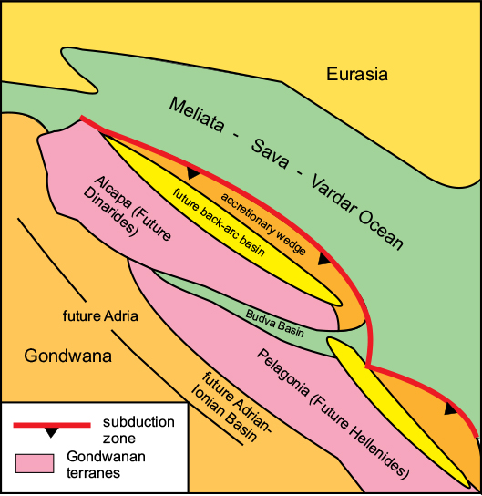
Figure 6.6 The Dinaride region in the early Triassic: reconstruction of the plate-tectonic elements. After Tari, 2002.
Tectonic history
The origin of the Dinarides lies in the relative movements of Adria, Alcapa and Tisza–Dacia. In the Triassic, Adria, Alcapa and Tisza, all parts of Gondwana, were separated from southern Eurasia by the Neo-Tethys Ocean (see Fig. 4.6). By this time most of the original Tethys Ocean had been subducted and replaced by branches of the Neo-Tethys Ocean, variously called the Meliata, Sava or Vardar Ocean, depending on in which sector of the orogenic belt the remnants are now found. Southwest-directed subduction of the Vardar Ocean crust along the eastern border of Alcapa from Triassic times led to the development of extensional back-arc basins on the northeastern margin of the Adria–Alcapa platform, one of which, the Budva Basin, separated what became the Dinarides from Pelagonia in the future Hellenides (Fig. 6.6). These extensional basins gave rise in the Jurassic to the ophiolites of the Eastern Thrust Belt. Also during the Jurassic, as explained above in discussing the origin of the Carpathians, both the Tisza and Dacia Terranes had also become detached from Eurasia by the formation of narrow oceanic basins, and by the early Cretaceous, Tisza had collided with Dacia and the combined Tisza–Dacia block then formed part of the Eurasian foreland to the evolving Dinarides.
From the late Jurassic through the Cretaceous, convergence between Alcapa and Tisza–Dacia was accommodated by subduction along the Alcapan margin, accompanied by west-directed thrusting and the development of an accretionary prism dominated by flysch deposits. On the eastern (Tisza) side of the Dinaride orogen, east-directed thrusting affected the accretionary prism.
During the early- to mid-Cretaceous, Vardar Ocean crust was being subducted beneath all three Gondwanan terranes, which were separated by narrow marine basins. Convergence between Adria and Alcapa in the mid-Cretaceous produced the Eo-Alpine collision belt, part of which subsequently became the Austro-Alpine belt of the Eastern Alps. Final closure of the Vardar Ocean near the end of the Cretaceous led to the collision between the Alcapa and Tisza Terranes. The westwards migration of the thrust front led to the imbrication of the Alcapa Platform, the uplift of the thrust belt, and the development of a foredeep basin beyond the thrust front, which also migrated towards the foreland.
The Main Dinaride orogenic event took place in the late Oligocene to early Miocene in response to the opening of the Western Mediterranean Basins, which resulted in the eastwards translation and counter-clockwise rotation of Adria, as indicated in Figure 5.3. This culminated in the under-thrusting of Adria beneath the Dinarides, the closure of the Budva Basin, and the formation and subsequent uplift of the Western Thrust Belt.
The Neogene movements were also responsible for two sets of dextral wrench faults: a more prominent NW–SE set parallel to the main tectonic boundaries, and a lesser NE–SW set that includes the Zagreb–Zemplin fault defining the northwest boundary of the Tisza Terrane. Extension and subsidence of the Pannonian Basin allowed the Sava accretionary prism and much of the Tisza basement to be overlain by thick molasse deposits. Movements continued through the Neogene, and the belt is still seismically active.
The Hellenides and the Rhodope Massif
The continuation of the Alpine Orogenic Belt south-eastwards into Albania and Greece is known as the Hellenides (Fig. 6.1). The belt as a whole is up to 300km wide here, and contains the prominent Pindos Mountains (Figs 6.7, 6.8), which have been described as the ‘spine’ of Greece, running through the middle of the Greek Peninsula and continuing through the Peloponnese. The Pindos Range is only 50–60km across and is typically between 1000 and 2000m in height; the highest peak is Mt. Smolikas (2637m), near the Albanian border. The highest mountain in Greece, Mt. Olympus, at 2911m, is not in the Pindos Range, but north of it, on the western shores of the Aegean Sea.
The Rhodope Massif is a mountain region over 200km in width, lying north of the Hellenides, mostly in southern Bulgaria, but extending into Thrace in northern Greece. It contains two separate mountain ranges: the Balkan Mountains, (or Stara Planina) in the north and the Rhodope Range in the south. The Balkan Mountains are the continuation of the south Carpathian fold belt discussed earlier, and separate the main part of the Rhodope Massif from the Moesian Platform in the north. This mountain range is only about 40km wide, and is not especially high; the Rhodope Range is higher and much wider, forming the greater part of the Massif. The highest peak in the Rhodopes is Musala, at 2925m.
Tectonic structure of the Hellenide–Rhodope Belt
The continuation of the Alpine Orogenic Belt into Greece is characterised by significant structural changes. In contrast to the Dinarides, which is a collisional belt, the Hellenides is an active continental margin with a subduction zone offshore in the Ionian Sea (Fig. 6.7). Eight tectonic zones are distinguished in this sector of the orogenic belt which, including the Rhodope Massif, has widened here to around 1200km. These are, from north to south: the Moesian Platform (part of the Eurasian foreland); the Rhodope Massif; the Serbo-Macedonian Zone; the Vardar–Axios Zone; the Pelagonian Zone; the Pindos (or Sub-Pelagonian) Zone; the Ionian Zone and the Hellenic Arc.

Figure 6.7 Tectonic Zones of the Hellenides. Alb, Albania; Bulg, Bulgaria; GC, Gulf of Corinth; Gre, Greece; Mac, Macedonia; MtS, Mt Smolikos; Pel, Peloponnese; S, Sophia; Ser, Serbia; Th, Thessaloniki. After Degnan & Robertson, 2006.
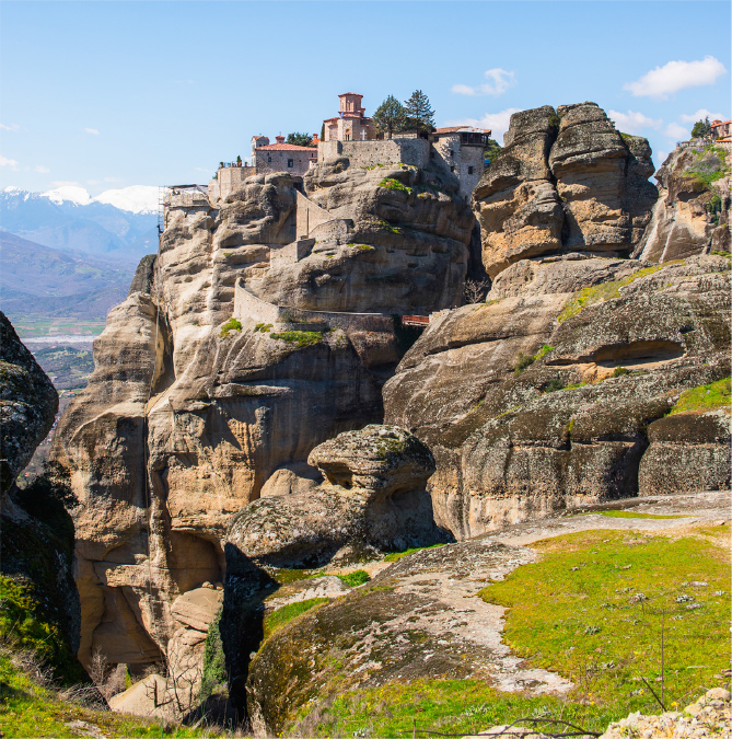
Figure 6.8 Sandstone cliffs in the Meteora Mountains: Pindos Range, Thessaly, Greece. © Shutterstock, by Anton Ivanov.
The Moesian Platform
This region, forming the southern foreland to the Carpathians, although belonging to the Eurasian continental plate, is now separated from it by a narrow Triassic rift. It consists of Palaeozoic basement with a Mesozoic shallow-marine sedimentary cover.
The Rhodope Massif
This broad zone consists of a high-grade metamorphic basement of Palaeozoic age together with a lower-grade metamorphosed Mesozoic cover, which includes a late Jurassic–early Cretaceous subduction–accretion complex. These metamorphic rocks are overlain unconformably by a late Cretaceous to early Neogene sedimentary cover. The Massif has experienced a late Cretaceous compressional event, which produced a stack of thrust nappes, and also an extensional event in the mid-Palaeogene that reversed the sense of movement on some of the earlier thrusts.
The Massif is considered to be part of the same terrane as Dacia, which forms part of the basement of the Pannonian Basin and was discussed earlier in the context of the Carpathians (see Fig. 6.2). This terrane was separated from the rest of the Eurasian continent by the early Mesozoic Vardar oceanic basin; this closed during the early Cretaceous Eo-Alpine collision that formed the Eastern Thrust Belt of the Dinarides.
The Serbo-Macedonian Zone
This zone is a Palaeozoic metamorphic massif, superficially similar to the basement of the Rhodope Massif, but exhibiting significant differences in its geological history. It is considered to be a separate terrane that joined the Rhodope Massif during the Hellenide orogeny.
The Vardar–Axios Zone
This zone consists of oceanic material of Mesozoic to Palaeogene age, including ophiolites, and is believed to represent oceanic crust of the Vardar Ocean that formerly separated the Gondwanan terranes from the Eurasian continental margin.
The Pelagonian Zone
This represents a terrane, originally part of the Alcapa Terrane, believed to have originated from Gondwana, and to have been separated from Eurasia by the Vardar Ocean (see Fig. 6.6). It appears to be the westwards continuation across the Aegean Sea of the Anatolian Terrane of Turkey (see Fig. 6.1).
The Pindos (or Sub-Pelagonian) Zone
This is similar to the Vardar–Axios Zone in containing oceanic material, but is somewhat older; it has been interpreted as an oceanic rift basin of Triassic age (the ‘Pindos Ocean’) that originally separated the Pelagonian Terrane from Gondwana. It now consists of a stack of folded thrust nappes containing a Triassic to Palaeogene sedimentary sequence, directed south-westwards over the underlying Ionian Zone.
The Ionian Zone
This zone, also known as the Gavrovo-Tripolitsa Zone, is the southern continuation of the Adrian platform in the Dinarides to the northwest. It forms the southwestern foreland onto which the Pindos nappes have been overthrust.
The Hellenic Arc
This currently active subduction zone begins just south of Corfu and curves around the southern side of Crete (see Fig. 6.1), forming the outer margin of the Hellenide sector of the Alpine Orogenic Belt. The Hellenic Arc is discussed in more detail below.
Tectonic overview
The Hellenide–Rhodope belt is a good example of a long-lived subduction–accretion complex, having formed as a result of repeated additions of both continental and oceanic terranes over a long period of time, beginning in the Jurassic. It includes the remnants of two major ocean basins – the Vardar Ocean in the northeast and the Pindos Ocean in the southwest (see Fig. 6.9).
The Rhodope Massif in the north became separated from the rest of the Eurasian continent by an early Mesozoic back-arc basin that formed on the upper plate of the subduction zone bounding the north side of the Tethys Ocean. This ocean basin was closed during the early Cretaceous (Eo-Alpine) contractional event that resulted in the Eastern Thrust Belt of the Dinarides.
Figure 6.9 Arrangement of continent and ocean in the Eastern Mediterranean in the late Cretaceous: a speculative reconstruction. CS, Caspian Sea; IPO, Inner Pontide Ocean; MM, Menderes Massif; CACC, Central Anatolian Crystalline Complex. After Robertson, et al., 2009
The Vardar–Axios Zone represents another ocean basin, the Vardar Ocean, which was initiated in the early Jurassic and existed through the Jurassic along the southern margin of the Eurasian continent. During this period, Vardar oceanic crust was being subducted north-eastwards beneath the Eurasian Plate. By the early Cretaceous, both the Rhodope Massif and Serbo-Macedonia had been added to Eurasia, and subduction continued beneath the Serbo-Macedonian Terrane. The Pelagonian Terrane, which had become detached from Alcapa, was situated across the Vardar Ocean to the southwest, and continued subduction through the Cretaceous led eventually to collision between Pelagonia and Serbo-Macedonia in latest Cretaceous to early Palaeogene times, producing the SW-directed Vardar–Axios fold-thrust belt.
The development of the Pindos Zone commenced in the Triassic as an oceanic basin offshore from the northeast margin of the Adrian Terrane. This ocean basin persisted throughout the Jurassic and early Cretaceous before being subducted beneath the Pelagonian Terrane in the mid-Cretaceous. The subduction complex is represented by an accretionary unit consisting of a stack of thrust sheets containing turbiditic flysch of early Palaeogene age. The main contractional event affecting the Pindos Zone was the development of a fold-thrust complex directed south-westwards towards the Ionian Platform during the mid-Palaeogene, which spread throughout the whole Hellenide belt, welding together all the formerly separate terranes – Rhodope, Serbo-Macedonia, Pelagonia and Ionia-Adria.
The Hellenic Arc
The Hellenic Arc is the most tectonically active part of the Hellenides. It consists of an inner volcanically active island arc and an outer non-volcanic arc, which includes the large islands of Crete and Rhodes, together with several smaller islands (Fig. 6.10). The arc is seismically active and has been responsible for many large (magnitude 7) earthquakes over the last century. The volcanic arc includes five volcanoes that have been active historically: Methana, Milos, Nisyros and Santorini (two), together with a further three (Kos, Poros and Yali) active in the late Neogene and Quaternary Periods. Santorini is famous for the catastrophic explosion in 1470BCE, which has been held responsible for the destruction of the Minoan civilisation of Crete. The outer non-volcanic arc extends from the island of Lefkada, at the northern end of the Ionian Island chain, to the island of Rhodes, off the Turkish coast.
The outer non-volcanic arc is fringed on its outward side by an ocean trench, the Hellenic Trench, which is considered to be a fore-arc basin, developed between the trench and the volcanic arc. The site of the subduction zone is concealed beneath the Mediterranean Ridge, which occupies a broad zone in the central part of the eastern Mediterranean Sea. This ridge is interpreted as an accretionary prism that has accumulated on the site of the subduction zone over a long period of time, filling in the original ocean trench. As can be seen in Figure 6.6, subduction of the oceanic part of the African plate has reached an advanced stage and only a small area remains south of the ridge.

Figure 6.10 The Hellenic Arc System. A. Principal tectonic features: active volcanic arc (red); inactive outer arc (blue) and Mediterranean Ridge (accretionary prism) (orange). Colours of other tectonic units as for previous figures. The site of the subduction zone is concealed beneath the ridge. The southern part of the Aegean Sea is a back-arc basin. Active or recently active volcanoes: K, Kos; M, Methana; Mi, Milos; N, Nisyros; P, Poros; S, Santorini; Y, Yali. Other locations: Ath, Athens; Lef, Lefkada; Pel, Peloponnese; Rh, Rhodes. B. Schematic crustal profile across the central part of the Hellenic Arc showing the main tectonic elements. Vertical scale approx. x2. A, after Okay, 2000; B, after Dilek & Altunkaynak, 2009.
The southern part of the Aegean Sea, inward of the volcanic arc, represents a back-arc basin, and the study of the active extensional faults, both in the Aegean islands and on the southern Greek mainland, indicates that the Hellenic Arc as a whole has experienced extension in an approximately NNE–SSW direction perpendicular to the arc, and also parallel to the arc as it has expanded outwards and stretched. The outward migration of the subduction zone, which has occurred over a period of at least 50Ma, from the Eocene Epoch to the present, has resulted in crustal thinning, leading to the depression of the whole Aegean Sea Basin. This process, which is common to many present-day island arc systems, is attributed to the gradual outwards retreat of the subduction zone due to the process of trench, or slab, roll-back, illustrated in Figure 6.10B.
The Alpine mountain belt continues eastwards from Greece, crossing the Aegean Sea into Turkey (Figs. 6.1, 6.11). Almost the whole of Turkey consists of a series of mountain ranges surrounding the high plateau of Anatolia (Fig. 6.4). The northern branch of the mountain system, known as the Pontides, forms two arcs fringing the southern shore of the Black Sea. The shorter Western Pontide chain extends from east of Istanbul to the Sinop Peninsula on the Black Sea coast; the longer, more easterly, Central and Eastern Pontide chains form a great southward-convex arc, extending for about 650km from Sinop to the border of Georgia at Batum (Fig. 6.12). These mountains increase in height towards the east, the highest peak being at 3937m. The central part of western Turkey consists of the high Anatolian Plateau, over 1000m in height, on which the capital, Ankara, sits. This great plateau is about 700km in length and up to 300km across and separates the northern Pontide ranges from the Taurus ranges in the south.
The southern mountain system is known as the Taurides which, at its western end, form a north-pointing ‘V’ shape enclosing the Bay of Antalya. Further east, the range curves around the south of the Anatolian Plateau and extends in a northeasterly direction to meet the Pontides in the high mountainous region of eastern Turkey, around the city of Erzerum. Mt. Ararat, at 5165m the highest mountain in Turkey (Fig. 6.13) is located here, near the borders with Armenia and Iran. The mountain belt then turns south-eastwards through Iran, to form the Zagros and Elburz ranges, discussed in the next chapter.
Tectonic setting
In geological terms, Turkey is a land of two halves: the western part, sandwiched between the Black Sea and the Eastern Mediterranean, is essentially a subduction–accretion complex, where subduction continues along the Hellenic and Cyprus trenches (see Fig. 6.1), whereas the eastern half is a collision belt between the Eurasian Plate in the north and the Arabian Plate in the south.
The main Alpine orogenic belt in Western Turkey (Fig. 6.12) is over 600km across at its widest point – over 800km if Cyprus is included – and is made up of two main tectonic zones, the Pontide Zone in the north and the Anatolian–Tauride Zone in the south, separated by the Izmir–Ankara Suture. The northern boundary of the Pontides is a major thrust that lies offshore along the coast of the extensional Black Sea Basin. The southern boundary of the Anatolian–Tauride Zone is effectively the Hellenic and Cyprus Trenches, which mark the currently active subduction zone defining the margin of the oceanic part of the African Plate.
In Eastern Turkey, the orogenic belt widens to include the Caucasus ranges in the north, and is bounded in the south by the Assyrian–Zagros suture marking the northern edge of the Arabian Plate. In this sector, the belt as a whole is just over 600km across. Here there are four main tectonic zones: the Greater Caucasus and Lesser Caucasus in the north, separated by the Rioni–Kura Basin, and the Anatolian–Tauride Zone in the south. The Lesser Caucasus is the eastern continuation of the Pontide Zone.

Figure 6.11 Mountain belts of Turkey and the Caucasus. Shutterstock©Arid Ocean.
Figure 6.12 Main structural elements of the Turkish Alpine Belt. Note the distribution of accretionary complexes, including ophiolites, in the Sakarya and Anatolide–Tauride Zones. AZS, Assyrian–Zagros Suture; BDF, Bitlis deformation front; CACC, Central Anatolian crystalline complex; DSF, Dead Sea Fault; EAF, East Anatolian Fault; IAS, Izmir–Ankara Suture; IPS, Intra-Pontide Suture; ITS, Inner Tauride Suture; LN, Lycian Nappes; NAF, North Anatolian Fault; RB, Rioni Basin; WBSF, West Black Sea Fault. Countries: Arm, Armenia; Az, Azerbaijan; Bul, Bulgaria; Ge, Georgia; Gr, Greece; Le, Lebanon. Cities: Ad, Adana; An, Ankara; Er, Erzerum; Is, Istanbul; Iz, Izmir; Si, Sivas; Tb, Tbilisi. Geographic names: LV, Lake Van; SM, Sea of Marmara; SP, Sinop Peninsula. After Okay, 2000.
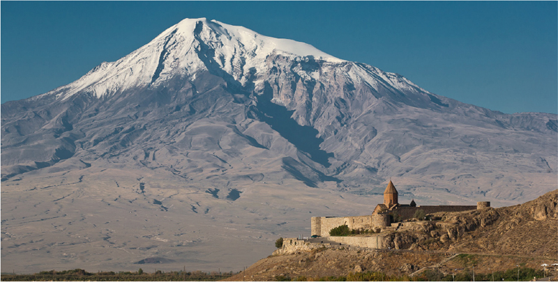
Figure 6.13 Mount Ararat, the highest mountain in Turkey. This is an extinct volcano situated on the high plateau near the Armenian border and the traditional resting place of Noah’s Ark. © Shutterstock, by Alexander Ishchenko.
The Pontide Zone
The Pontides are an amalgamation of three separate terranes: the Strandja, Istanbul and Sakarya Terranes, which came together during the mid-Cretaceous. The Strandja Terrane is the eastern equivalent of the Rhodope Massif already referred to when discussing the Hellenides (see Fig. 6.7), and forms the basement of that part of Turkey northwest of the Sea of Marmara. It is cut off on its eastern side by a NNW–SSE transform fault, the West Black Sea Fault, which terminates the extensional West Black Sea Basin. East of this fault is the Istanbul Terrane, considered to have been part of the Moesian Platform, now on the northwest side of the Black Sea, until the early Neogene, when it was displaced southwards by the opening of the Black Sea Basin.
Like the Rhodope Massif, the Strandja and Istanbul terranes have a Palaeozoic basement of Laurasian type. These terranes are separated from the Sakarya Terrane by the NW-dipping Intra-Pontide Suture. This suture zone consists of imbricated thrust units of Mesozoic oceanic material considered to represent the remnants of the Neo-Tethyan Vardar Ocean, which was subducted beneath the Istanbul Terrane until the two terranes collided in the Palaeogene.
The Sakarya Terrane occupies the remainder of the Pontide Zone from the Mediterranean coast north of Izmir, eastwards along the southern side of the Black Sea towards the border with Georgia. It has a Palaeozoic basement of Eurasian parentage, with a Jurassic to mid-Cretaceous platform cover. The Sakarya Terrane is a composite unit containing numerous thrust slices, some of which contain Cretaceous flysch deposits and oceanic material, including ophiolites. The northern boundary of the Sakarya Terrane in the Central and Eastern Pontides is concealed beneath the Black Sea Basin but appears in the Caucasus as a south-dipping thrust defining the northern margin of the Lesser Caucasus. The Caucasus sector is discussed separately below. The southern boundary of the terrane is the Izmir-Ankara suture zone, which is another complex thrust belt like the Intra-Pontide suture, containing oceanic material attributed to the Vardar Ocean. The western boundary of the terrane is obscured beneath the Aegean Sea.
All three terranes in the Pontide Zone have experienced significant Cretaceous deformation as well as the main late Palaeogene to early Neogene Alpine tectonic event.
The Anatolian–Tauride Zone
This zone occupies the southern part of Turkey, bounded in the north by the Izmir–Ankara Suture, in the southwest by the Mediterranean Sea and in the southeast by the Assyrian-Zagros Suture. It differs from the northern terranes in possessing a basement of African type, similar to that of the Arabian Plate, affected by early Cambrian (Pan-African) and late Palaeozoic orogenic events. There are three main components in this zone: the Taurides, the Kirsehir Massif (also known as the Central Anatolian Crystalline Complex or CACC) and the Menderes Massif, the latter two being known collectively as the Anatolides. The Anatolides represent the metamorphosed, structurally lower, northern part of the zone and would have been underthrust beneath the Sakarya Terrane during the collision with it.
The Taurides consist of a series of thrust sheets containing mostly sedimentary rocks of Palaeozoic to early Neogene age. The top thrust slice in each unit is composed of ophiolitic material which forms large outcrops throughout the Taurides, some of the more prominent of which are shown in Figure 6.12. The thrust sheets were mostly assembled during the late Cretaceous and culminated in the early Palaeogene with a major contractional event caused by the collision between the Anatolian–Tauride block and the Pontides. The thrust sheets were emplaced southwards with the exception of the southernmost, around the Bay of Antalya, which appear to have been emplaced towards the north. The more northerly thrust slices, which belong to the lower plate in the collision with the Pontides, and were overthrust by them, have been subjected to high–pressure-low temperature metamorphism. The Lycian nappes in the south are overlain by ophiolites considered to represent the southern branch of the Neo-Tethys Ocean.
The Central Anatolian Crystalline Complex (CACC), otherwise known as the Kirsehir Massif, occupies the central part of the Anatolian Plateau. It consists of metamorphic and granitic rocks of late Cretaceous age overlain by Neogene sediments and volcanics. The complex is bounded in the north by the Izmir–Ankara suture separating it from the Pontides, and in the south by the Inner Tauride Suture, separating it from the other units of the Anatolian–Tauride Zone. Both thrust boundaries are inclined northwards, and, like the Taurides, the complex lay on the lower plate of the collision with the Pontides. The complex may represent an individual terrane originally isolated from the Pontide and Tauride blocks by branches of the Neo-Tethys Ocean, as indicated in Figure 6.9.
The Menderes Massif is located in the westernmost part of the Anatolide–Pontide Zone, southeast of the city of Izmir. It has experienced a similar tectonic history to that of the Kirsehir Massif and has been described as a metamorphic ‘core complex’, similar to other Alpine core complexes, such as the Alboran and Pennine zones discussed in previous chapters, in possibly having been uplifted during an extensional process. However, unlike the Kirsehir Massif, it may not represent a separate terrane. The Menderes Massif is bounded on its southern side by a south-dipping thrust. The Tauride units southeast of this boundary, known as the Lycian Nappes, consist of unmetamorphosed units overthrust westwards onto the Massif.
The southern margin of the Anatolian–Tauride Zone is the plate boundary marking the northern edge of the African Plate. It consists of two arcuate trenches, the Hellenic Trench in the west, shown in Figure 6.10, and the Cyprus trench in the centre, connected by a transform fault. The eastern end of the Cyprus trench is linked via another transform fault to the Dead Sea Transform Fault and the Assyrian–Zagros Suture, which together form the boundary of the Arabian Plate. Cyprus itself contains the famous Troodos Massif, one of the first ophiolite complexes to be recognised.
Tectonic history
At the beginning of the Mesozoic, much of present-day Turkey lay on the northern margin of Gondwana, separated from Eurasia by the wide Tethys Ocean (see Fig. 4.4A). Oceanic lithosphere of the Palaeo-Tethys Ocean was being subducted southwards beneath the northern margin of Gondwana, and northwards beneath Laurasia, resulting in the opening of a series of back-arc basins in the Triassic. These new oceanic basins, collectively known as Neo-Tethys, separated the new continental terranes from both Laurasia and Gondwana. The northern Neo-Tethys branches are now represented by the Intra-Pontide, Izmir–Ankara and Inner Tauride sutures. The southern branch of Neo-Tethys is represented by the remnant of the oceanic part of the African Plate, which is being subducted beneath the Cyprus Trench. During the Jurassic, the original Tethys Ocean (Palaeo-Tethys) was consumed, leaving only the various branches of Neo-Tethys.
Figure 6.9 is a reconstruction of the possible arrangement of continental and oceanic areas in the late Cretaceous. The Sakarya continent lay within the northern Neo-Tethys, separated from Eurasia by the Intra-Pontide Ocean. South of this were two other small terranes, the Pelagonian and Kirsehir Terranes, also within the northern Neo-Tethys Ocean. Across the Aegean Sea, in the Hellenides, the Pelagonian Terrane divided this large oceanic area into two branches: the Vardar Ocean in the north and the Pindos Ocean to the south; however, this terrane does not appear to extend eastwards into Turkey. Here, the northern Neo-Tethys is known as the Izmir–Ankara Ocean in the north and the Inner Tauride Ocean in the south. All these oceanic areas were probably connected. The southern margin of this Neo-Tethyan Ocean lay along the northern edge of the large Anatolian–Tauride Platform, which was probably continuous with the Adria–Alcapa platform further west in the Balkans, and represented by the Ionian Zone in the Hellenides (see Figs 6.5 and 6.7). All these terranes were covered by shallow-marine sediments.
The Anatolian–Tauride Massif is part of a large super-terrane named ‘Cimmeria’ which was attached to Gondwana until the beginning of the Triassic Period, when it broke away, opening up the southern branch of the Neo-Tethys Ocean. Cimmeria was a long, thin micro-plate, parts of which now form the Iranian, Afghanistan and Tibetan Plateaux in addition to the Anatolian Plateau, and which also extends eastwards into Indochina and Malaysia.
In the south, where the southern Neo-Tethys Ocean lay between the Anatolian-Tauride platform and Africa, the small Cyprus terrane became separated from the southern margin of Anatolian-Taurides by the Antalya back-arc basin.
From mid-Cretaceous times, consumption of the Neo-Tethyan oceanic lithosphere occurred by northwards subduction beneath the Eurasian, Sakaryan and Anatolian-Tauride margins. The Black Sea basin developed as a back-arc basin above the southern Eurasian margin, splitting off the Istanbul terrane from the rest of Eurasia. In the late Cretaceous, ophiolite nappes were being obducted onto the northern margins of the Anatolian-Tauride and Arabian Platforms. During the Eocene, the Anatolian-Tauride Platform collided with Sakarya, Strandja–Istanbul and southern Eurasia to create the Pontides; and by the Miocene, Arabia had collided with the enlarged Eurasian Plate, producing strong contractional deformation in the Central and Eastern Taurides and also throughout the whole system. This Miocene event produced southward-directed thrust slices, causing the imbrication of the Anatolian-Tauride platform. Since then, the main tectonic movements have been concentrated along a major strike-slip fault system based on the North and East Anatolian Faults, which have accommodated the further convergence between the Arabian and Eurasian Plates by westwards movement of the Anatolian Plateau.
Figure 6.14 is a reconstruction of the possible sequence of tectonic events leading up to the present disposition of terranes. There are other possible ways of explaining the present geology, and the actual history is very much more complex, but the sequence shown here is an illustration of how a subduction–accretion complex can be built up from successive events of extensional rifting, subduction, and collision.
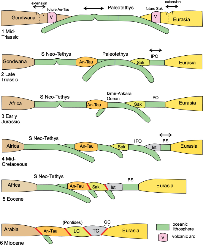
Figure 6.14 Possible sequence of tectonic events affecting the Turkish sector of the Alpine belt. Cartoon sections, greatly simplified: 1–5 Western Turkey; 6, Eastern Turkey and the Caucasus. An-Tau, Anatolian–Tauride Terrane; BS, Black Sea Basin; GC, Greater Caucasus; IPO, Intra-Pontide Ocean; Ist, Istanbul Terrane; LC, Lesser Caucasus (= Sakarya Terrane); TC, Trans-Caucasian Terrane.
The Caucasus
The Caucasus sector of the Alpine Orogenic Belt consists of two distinct mountain belts: the Greater and Lesser Caucasus, separated by the Trans-Caucasian Massif. As described earlier, the Lesser Caucasus is the lateral extension of the Pontide Zone of northern Turkey (see Fig. 6.12). The western end of the Greater Caucasus is cut off by the Black Sea, but reappears in the Crimean Peninsula as the Yayla Range, itself terminated by the West Black Sea Basin at its western end (see Fig. 6.1). However, the southern Eurasian margin continues westwards along the southern margin of the Black Sea to link up with the Balkanide range, which defines the southern limit of the Moesian Platform. The eastern end of the Greater Caucasus range is cut off at the Caspian Sea coast, but the Lesser Caucasus curves around the southern end of the Caspian Sea to join the Elburz Range in Iran, discussed in the following chapter.
The Greater Caucasus mountain range extends for c.1300km from the northeastern shore of the Black Sea to the western shore of the Caspian Sea (Figs 6.15, 6.16). It includes many mountains over 5000m high, including Mount Elbrus which, at 5641m, is Europe’s highest mountain. Many of these peaks are Neogene volcanoes – some, including Mount Elbrus itself, recently active, and the region is strongly seismic, having experienced many severe earthquakes in recent times. The Yayla sector is narrow and relatively insignificant in comparison with the Caucasus ranges; the Balkanides, however, although also narrow, contain several prominent mountains, including Yamruchka, the highest peak in the range, at 2376m.
The Greater Caucasus Zone
This zone is divided into four tectonic units: the Scythian Platform, or northern foreland, the Front Range, Main Range, and Southern Slope (Fig. 6.15).
The Scythian Platform has a Palaeozoic basement of Eurasian origin, mostly concealed under a thick cover of Cenozoic molasse. The molasse deposits are concentrated in separate foredeep basins immediately north of the Caucasian Front, including the Azov–Kuban, and Terek–Caspian Basins, which are separated by basement highs.
The Greater Caucasus Front Range consists of a stack of north-directed thrust sheets containing Palaeozoic basement overlain by an unconformable cover of Jurassic sediments and volcanics. The Greater Caucasus Main Range also consists of a Palaeozoic basement complex folded into a series of antiforms separated by synforms containing Jurassic black slates. This zone is thrust southwards over the Southern Slope Zone.
The Southern Slope unit consists of a similar sequence to the Front and Main Ranges overlain unconformably by late Jurassic to early Palaeogene flysch deposits. This complex was intensely folded in the early Neogene and affected by south-directed overthrusts, the most southerly of which separates it from the Trans-Caucasian Massif.
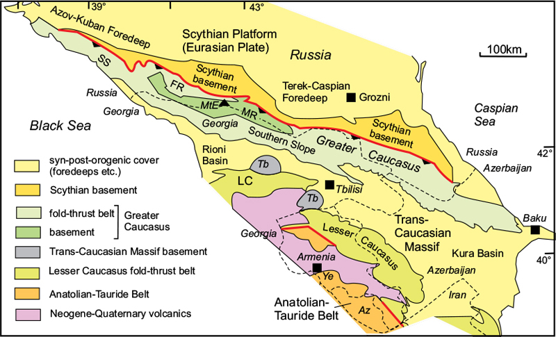
Figure 6.15 Main tectonic units of the Caucasus Region. Greater Caucasus: FR, Front Range; MR, Main Range; SS, Southern Slope. LC, Lesser Caucasus; Tb, Trans-Caucasian basement. Az, Azerbaijan; MtE, Mt Elbruz; Ye, Yerevan. After Adamia et al., 2011.
The Trans-Caucasian Massif
This zone forms a topographic depression between the Greater and Lesser Caucasus mountain ranges. It consists of a late Palaeozoic (Variscan) basement overlain by a Mesozoic to Cenozoic cover of sediments and volcanics. The pre-Mesozoic basement is exposed in the central part of the zone but is overlain by sedimentary basins, the Rioni Basin in the west, and the Kura Basin in the east. The Trans-Caucasian Terrane is considered to have separated from Eurasia during the early Mesozoic by the formation of a back-arc basin, then collided with Eurasia again in the early Neogene. In this respect it is similar to the Istanbul Terrane in Western Turkey.
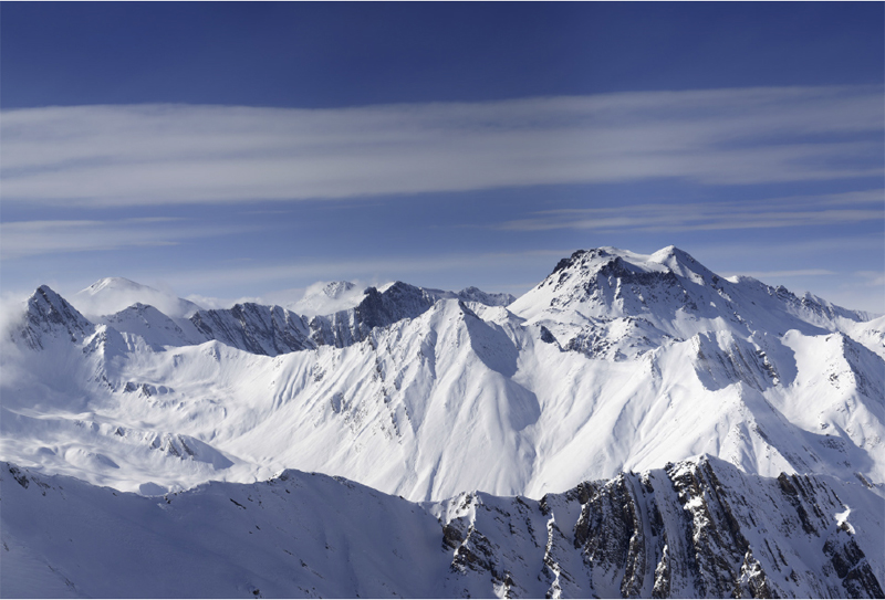
Figure 6.16 The Caucasus Mountains. The Greater Caucasus Range on the border between Russia and Georgia is the result of the final collision between the Arabian and Eurasian Plates. © Shutterstock, by Lizard.
The Lesser Caucasus
This zone is the eastwards extension of the Pontides of Turkey, discussed above.
Tectonic history
The Caucasus region has experienced repeated periods of orogenic activity (Fig. 6.14). The Trans-Caucasian Terrane appears to have separated from the Eurasian margin during the Triassic. The Lesser Caucasus Terrane, equivalent to the Pontides Zone further west, was added to the Eurasian margin in the early Jurassic and the Anatolian–Tauride Terrane in the Cretaceous, as well as pieces of oceanic and island-arc crust, as Neo-Tethyan oceanic crust was subducted northwards beneath Eurasia. The latest, and most severe, orogenic episode was caused by collision between the previously assembled terranes and the Arabian Plate during the late Miocene Epoch. Tectonic activity has continued to the present day: large earthquakes (magnitude 6–7) have recently affected the southern foothills of the Greater Caucasus, associated with the suture between it and the Trans-Caucasian Massif, and Neogene to Quaternary volcanic activity has produced the extensive lavas of the Armenian Plateau together with extinct volcanoes, such as Elbrus, in the Greater Caucasus.