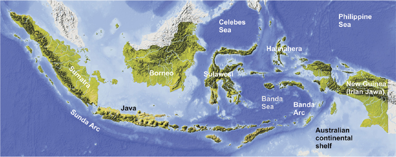
Southeast Asia
After turning southwards through Burma and southwest China, the Alpine–Himalayan mountain belt follows a north-south trend into Thailand and the Malaysian Peninsula, then curves round eastwards in a great arc into Western Indonesia (Fig. 9.1). The more westerly, relatively minor, branch follows the eastern margin of the Indian Plate as the Arakhan Range, the southern extension of the Patkai–Chaga–Chin belt discussed in the previous chapter. The Arakhan belt continues as a subduction zone along the coast of Burma to Cape Negrais, forming the eastern margin of the oceanic part of the Indian Plate. From this point, the western margin of the mountain belt is an island arc that curves in a wide sweep through the Andaman and Nicobar Island chains and continues through Sumatra and Java as the Indonesian Island Arc.
The more easterly branch of the Alpine–Himalayan mountain system descends southwards through eastern Burma and southwestern China as a 1000km-wide belt containing many roughly parallel mountain ranges. These ranges decrease in height southwards until they gradually die out in northern Thailand and Indochina.
Most of northern Thailand is a featureless plain, except for a narrow mountain chain that runs down the centre of the country to just northeast of Bangkok, following the eastern margin of the Chanthaburi Terrane (see below). A second narrow mountain range, rising to over 2000m in southern Burma, follows the Burma–Thailand border and continues down the spine of the Malaysian Peninsula, where several peaks in the Cameron Highlands are over 2000m. The latter range, which is over 2000km long, lies within the Sibumasu Terrane, discussed below. Between the western and eastern branches of the mountain system lies the wide Andaman Sea, which is an active back-arc basin 1000km in length and 600km wide.
The Southeast Asian Fold Belt
Tectonic context
Southeast Asia is composed of a mosaic of separate continental terranes that have Gondwanan origins, and have joined the Siberian core of Eurasia at different times. The largest of these are the North China, South China and Indochina–East Malaya blocks, which are largely stable areas founded on Precambrian basement. All these stable blocks left Gondwana in the Devonian Period but travelled separately towards Siberia: Indochina joined South China during the early Carboniferous and the combined South China–Indochina–East Malaya block joined North China in the late Triassic. At about the same time, the Sibumasu Terrane, which represents the southernmost extremity of Cimmeria, also became attached to the combined South China–Indochina–East Malaya ‘super-terrane’, which finally joined Eurasia during the Jurassic.
Figure 9.1 Relief map of Indonesia showing the main topographical features. © Shutterstock, by Arid Ocean.
The effect of the Indian collision during Eocene to Oligocene time was to force the Gondwanan terranes of Tibet eastwards and south-eastwards, wrapping them around the northeastern corner of the Indian Plate, and squeezing them against the more stable blocks to their east (see Figs 8.2 and 8.8 in the previous chapter). The large mountainous region that embraces eastern Burma, northern Laos and southwest China is, at least partly, the result of compression and uplift responding to the north-eastwards motion of the continental part of the Indian Plate. The southeast Asian sector of the Alpine–Himalayan orogenic belt thus falls into two distinct parts: the northern, running through northern Burma and Southwest China, resulted from the convergence between the Indian and Eurasian Plates, whereas the southern part represents the response to the convergence between the Australian Plate and Eurasia, and comprises southern Burma, Thailand and Indochina, together with the Malay Peninsula and the island arc system extending from the Andaman Islands to Indonesia.
Tectonic zones of the Southeast Asian Fold Belt
This north–south belt can be divided into six distinct tectonic zones east of the Indian and Australian plate boundaries (Fig. 9.2). These are: from west to east, the Western Accretionary Zone, the West Burma Terrane, the Sibumasu Terrane, the Chanthaburi Arc Terrane, the Indochina Terrane and the South China Terrane. These terranes are separated by major sutures, formed at different times, each of which has experienced renewed compressional effects as a result of the Himalayan convergence.
The fold belt is flanked on its western side by a subduction zone running parallel to the eastern coast of the Bay of Bengal. Along this section of the plate boundary, the oceanic part of the Indian Plate is moving north-eastwards beneath Asia. South of Cape Negrais, the western margin of the fold belt is replaced by the Andaman–Nicobar island arc chain, which follows the subduction zone marking the boundary of the oceanic part of the Australian Plate. The two oceanic plates are separated by a N–S-trending transform fault – the Ninety-East Ridge (see Fig. 10.1); east of this fault, the northeasterly convergence direction is unchanged, although the convergence rate is faster. The two plates are often regarded as a single Indo–Australian Plate, but the difference in convergence rates between them has produced a zone of deformation west of the Nicobar Islands that will eventually result in a new plate boundary.
The Western Accretionary Zone
This zone corresponds to the Chin–Naga–Patkai fold-thrust belt discussed in the previous chapter, and consists of the deformed Cenozoic sedimentary cover of the Indian Plate (see Figs 8.2, 8.10). Its western boundary is the Naga Thrust, which defines the western margin of the fold belt, and the zone is bounded in the east by the Mawgyi Suture, which separates it from the West Burma block. The Mawgyi Suture is the most westerly and most recent of the sutures separating the six terranes, having finally closed during the Himalayan collision in the Oligocene. It corresponds to the Indus–Tsangpo suture in Tibet.
South of the Bangladeshi-Burma border, the onshore part of the zone is represented by the Arakhan mountain range, but the greater part of the zone lies offshore between the subduction zone and the mainland coast. South of Cape Negrais, the entire zone swings offshore to become the Andaman–Nicobar Island Arc, which is separated from the Burmese mainland by the active Andaman Sea back-arc basin, formed 4Ma ago. The island chain consists mainly of Neogene sedimentary rocks forming an accretionary complex similar to that of the Arakhan Range to the north, and is strongly active seismically, having experienced several severe earthquakes in recent years, including the disastrous Banda Aceh event in 2004. The arc curves round to a NW–SE orientation through Sumatra, where part of the zone appears onshore. Here, the zone is bounded on its northeast side by the West Sumatra Block, which is regarded as the probable continuation of the West Burma Block, with the same origin. The northern part of the arc is highly oblique to the convergence direction of the Australian Plate and is cut by numerous N–S sinistral strike-slip faults. Because present-day motion in this sector makes such a small angle to the plate boundary, there is no active vulcanicity.
The West Burma Terrane
This relatively stable block, centred on the Irrawaddi Valley, separates the Arakhan mountain range in the Western Accretionary Zone from the much higher ranges of eastern Burma and Yunnan Province in China. The terrane is thought to have separated from Gondwana in the Devonian, like the larger Indochina and South China terranes. On its eastern side, it is bounded by the Shan Boundary Suture, separating it from the Sibumasu Terrane. The Shan Boundary Suture is a continuation of the Banggong–Nujiang Suture in Tibet.
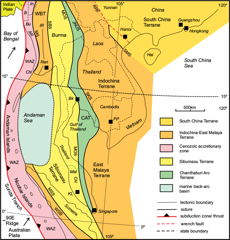
Figure 9.2 Main tectonic units of SE Asia. Note: the Indonesian islands east and southeast of Malaysia are shown in Figure 9.6. CAT, Chanthaburi Arc Terrane; JNUS, Jinghong–Nan Uttaradit Suture; MOS, Main Ocean Suture; MS, Mawgyi Suture; MSS, Mid-Sumatra Suture; RRF, Red River Fault; SBS, Shan Boundary Suture; SKS, Sra Kaoe Suture; SMS, Song Ma Suture; WAZ, Western Accretionary Zone; WBT, West Burma Terrane; WSB, West Sumatra Block. Geographical names: AR, Arakhan Range; B, Bangladesh; Bk, Bangkok; Bu, Burma; CH, Cameron Highlands; CN, Cape Negrais; In, India; IR, Irrawaddi River; KL, Kuala Lumpur; Mal, Malaysia; PP, Phnom Penh; Ran, Rangoon. After Metcalfe, 2011.
South of the Andaman Sea, this suture reappears as the Mid-Sumatra Suture, separating the West Sumatra Block from the Sibumasu Terrane. The Shan Boundary–Mid-Sumatra Suture is thought to be the site of a branch of the Palaeo-Tethys Ocean; however, the present boundary is a strike-slip shear zone and there is no direct evidence of oceanic material.
The Sibumasu Terrane
The name of this terrane is an amalgam of Sino–Burma–Sumatra, reflecting the three regions through which it passes. It is the southernmost part of the long, thin Cimmerian ‘super-terrane’, represented in Tibet by the Qiangtang Terrane (see Fig. 8.2), which was bent southwards as a result of the Himalayan collision. In common with the other parts of Cimmeria, Sibumasu was detached from Gondwana in the Permian, and joined the Indochina Terrane during the Triassic. Between the two is the narrow volcanic arc terrane known as the Chanthaburi Terrane.
The Sibumasu Terrane is represented in the Shan Ranges of Northern Burma and by the narrow mountain belt that runs down the spine of the Malay Peninsula through the Cameron Highlands to Kuala Lumpur.
The Chanthaburi Arc Terrane
This volcanic arc terrane between the Sibumasu and Indochina terranes extends from Eastern Burma to southern Malaysia, with a large gap where it is inferred to cross the Gulf of Thailand. The suture between it and the Sibumasu Terrane, known as the Main Ocean Suture, is regarded as the site of the former Palaeo-Tethys Ocean, closed during the Triassic Period, and is represented by an accretionary complex. The main part of the terrane consists of a volcanic arc, which is separated from the western margin of the South China–Indochina block by a second suture zone. This second zone is interpreted as a former subduction zone marking the site of a closed back-arc basin, which had opened during the late Carboniferous to early Permian between the volcanic arc and the main part of the Indochina Block, and closed again in the late Permian. This eastern suture, confusingly, is known by three different names: Jinghong in China, and Nan Uttaradit and Sra Kaoe in Thailand.
The Indochina Terrane
This large, stable block is effectively the foreland of this sector of the orogenic belt. It occupies almost the whole of Indochina and is considered to correlate with the East Malaya Block south of the Gulf of Thailand. In common with South China, it consists of Precambrian basement of Gondwanan affinity and separated from Gondwana in the Permian. It joined South China in the late Triassic and the combined terranes finally joined Asia in the Jurassic.
The South China Terrane
This terrane forms part of the stable foreland of the South Asian fold belt. The suture separating it from the Indochina block is known as the Song Ma Suture in Indochina (equivalent to the Ailaoshan suture in the Chinese sector). It is displaced by the major strike-slip Red River Fault, which has caused the Indochina block to be displaced sinistrally, squeezed southwards by the Himalayan collision.
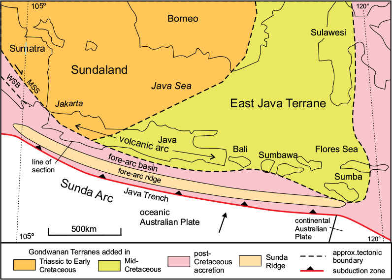
Figure 9.3 The Sunda Arc. Main tectonic units of the Sunda Arc and its foreland. MSS, Mid-Sumatra Suture; WSB, West Sumatra Block. There are a large number of volcanoes on the Sunda Arc, too numerous to show on this map. After Hall, 2011.
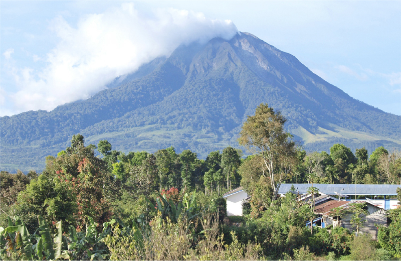
Figure 9.4 Mount Sinabung, NW Sumatra. This 2460m peak is typical of the active andesitic volcanoes of the Sunda Arc. Shutterstock©TJUKTJUK.
The Sunda Arc
The Sunda island arc system includes the large islands of Sumatra and Java, together with three smaller islands to their east, ending in the island of Sumbawa (Figs. 9.1, 9.3). The arc system is over 3200km in length – Sumatra alone is about 1750km long and up to 400km across. Both main islands are dominated by impressive mountain ranges containing many active volcanoes; some of these, especially in Java, are well over 3000m in height. The highest is Kerinci, at 3805m, in Sumatra. One of the most active volcanoes is Sinabung, in northern Sumatra (Fig. 9.4) which is situated at the northwest end of an enormous, 100km-long, crater lake. Sinabung has experienced a series of explosive eruptions in recent years, resulting in numerous casualties. Another well-known volcano is the slightly smaller Sibayak, which although no longer actively erupting, exhibits geothermal activity in the form of steam vents and hot sulphurous springs. The Sunda Arc is typical of subduction-related volcanic arcs in exhibiting mainly andesitic vulcanicity and explosive eruptions.
The mountain ranges are narrow, less than 100km wide; in the case of Sumatra they closely follow the southern coast, while the remainder of the island is a broad, featureless plain (Fig. 9.1). The large islands form a wide arc that trends NW–SE in Sumatra and E–W at its eastern end in Sumbawa. About 150km offshore is a second, outer, arc composed of a chain of smaller islands situated on a submerged ridge extending for the whole length of Sumatra but much subdued off Java. The Sunda subduction zone occupies a trench that lies 200–300km offshore from the main islands. This trench, known as the Sunda Trench off Sumatra, and the Java Trench further east, reaches over 6km in depth south of Java but disappears as an obvious topographic feature in the northwestern part of the outer arc.
Tectonic summary
Although currently part of the same active volcanic arc system, the islands of Sumatra and Java differ significantly in their geological composition and history. As shown in Figure 9.2, Sumatra is divided into three tectonic zones: the northeastern part of the island is part of the Sibumasu Terrane described above, which occupies the low-lying plain and is separated from the West Sumatra Block by the Median Sumatra Suture, which is a dextral strike-slip fault. The volcanic arc is situated within the West Sumatra Block. The outermost zone is the accretionary terrane, containing post-Cretaceous sediments deformed in a fold-thrust belt. This outer zone is exposed in the outer coastal parts of Sumatra and in the outer islands, but much of it is submerged.
In Java (Fig. 9.3), the northern foreland is more complex: the western part, known as Sundaland, includes western Borneo and the Java Sea between it and West Java, and is underlain by Gondwana-derived crustal blocks added to East Malaya prior to the mid-Cretaceous. The eastern part, known as the East Java Terrane, is mostly occupied by mid-Cretaceous accretionary material. The island itself, together with the smaller islands to the east, consists almost entirely of volcanoes and volcanic material belonging to the active Sunda Arc, which is situated along the margin of the Sundaland and East Java terranes. The offshore part of the arc differs from Sumatra in that the accretionary prism occupies a submerged ridge, the fore-arc ridge, separated from the islands by the fore-arc basin, which is a 50km-wide elongate trough. Figure 9.5 is a section across the offshore arc structure obtained from refraction seismic data. The trench, which here is about 5km deep, lies more than 50km south of the ridge. The seismic section, one of a series taken across the arc, indicates that the oceanic slab is descending at a relatively shallow angle beneath Java and that the accretionary prism here is over 20km thick. The current convergence rate across the arc is up to 70mm/a in a NNE–SSW direction.
Eastern Indonesia
The part of Indonesia north and east of Java is a confusing jumble of islands of various sizes, the largest being Borneo in the west and New Guinea in the east (Figs. 9.1, 9.6). The Sunda Island Arc is followed eastwards by a string of smaller islands known as the Lesser Sunda Islands. These in turn give way eastwards to the Banda Arc system, which consists of two parallel arcs, which both curve through almost 180° around the Banda Sea. The inner, volcanic arc consists of a series of very small islands linked by a submerged ridge, which ends at the larger island of Seram. The outer, inactive, arc is situated on the margin of the Australian continental shelf and includes the large island of Timor as well as several smaller islands, and ends near the southern coast of New Guinea. All the larger islands are mountainous: the highest peak in the Banda Arc is Binaiya, 3019m, on the island of Seram.
North of the Banda Sea, between Borneo and Seram, is the strangely shaped island of Sulawesi (formerly Celebes). Sulawesi has the appearance of a strange beast whose long neck is twisted round to face backwards towards the east! Two promontories (West Sulawesi and South Sulawesi – the ‘legs’) project southwards, the ‘tail’ (East Sulawesi) points eastwards, and the long thin neck (North Sulawesi) at the north end of the island curves round into an arc facing south across the Molucca Sea. Sulawesi is interesting in being composed of several pieces of crust with quite different origins: westernmost Sulawesi is part of Sundaland, which by the Cretaceous formed part of Eurasia; South and East Sulawesi, the southern and eastern promontories, were originally part of continental Australia; while North Sulawesi is part of an active volcanic arc along the margin of the Celebes Sea Basin.
The eastern part of Indonesia is dominated by the large island of New Guinea, of which only the western half (Irian Jawa) belongs to the State of Indonesia; the eastern half is the separate country of Papua New Guinea. New Guinea is situated on the northern side of the Australian continental plate, and belongs to the circum-Pacific orogenic belt system; it contains a central spine of high mountains, rising to over 5000m. This belt continues northwards through the island of Halmahera and continues into the Philippines. This sector of the belt will be discussed in the following chapter. There are several small ocean basins in the topographically complex region east of Sundaland. From north to south, these are: the Sulu, Celebes, North Banda and South Banda Basins. The Celebes Basin is bounded by a subduction zone on its eastern and southern sides; the North Banda Basin is bounded by a subduction zone on its western side and a transform fault to the north; the South Banda Basin is situated on the inner side of the Inner Banda Arc. On the eastern side of the orogenic belt is the Pacific Ocean, which is represented here by the Philippine Sea Plate.
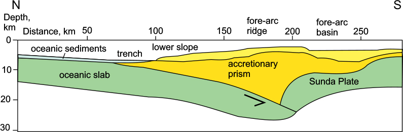
Figure 9.5 The offshore Sunda Arc. Simplified topographic section based on refraction seismic data across the western part of the arc, showing the accretionary prism. Lower higher-density part of the prism in orange; upper, lower-density material in yellow; oceanic sediments in blue. After Kopp, 2011.
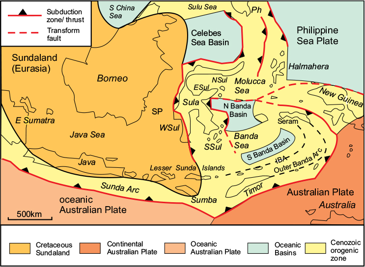
Figure 9.6 Main plate-tectonic elements of Central and Eastern Indonesia. ‘Sundaland’ represents the extent of stable Eurasian crust added in the Cretaceous to the northern side of the Cenozoic orogenic belt system. ESul, East Sulawesi; IBA, Inner Banda Arc; NSul, North Sulawesi; PH, Philippines; SSul, South Sulawesi; Sula, Sulawesi; WSul, West Sulawesi. After Hall, 2011.
Tectonic context
The region of Indonesia east of Sumba island, including Sulawesi, Timor, the western part of New Guinea, and the many smaller islands, is one of the most structurally complex of the whole Cenozoic orogenic belt system. The main reason for its complexity is its position at the junction of three plates: the continental part of the large Australian Plate to the south, Sundaland (part of Eurasia) to the west, and the oceanic Philippine Sea Plate to the east and north.
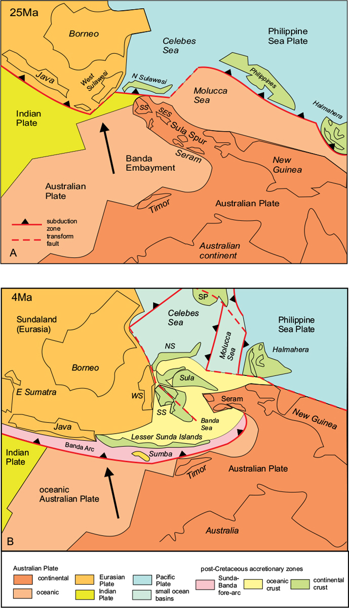
Figure 9.7 is a reconstruction of how the plate-tectonic framework of Eastern Indonesia evolved during the Neogene. During the Palaeogene Period, oceanic parts of two plates, the Indian and Australian Plates, were being subducted beneath Southeast Asia and the Philippine Sea Plate respectively, and the plate boundary network then was relatively simple. However, as the Australian continent approached Southeast Asia in the Miocene, as illustrated in Figure 9.7A, the shape of the northern margin of Australia became critical: the first point of contact was a large spur, the Sula Spur, which projected north-westwards from the western end of New Guinea. This NW–SE promontory contained the western part of New Guinea together with Seram, Southern and Eastern Sulawesi, and many smaller islands. Elsewhere, the oceanic part of the Australian Plate on the northeast side of New Guinea was being subducted beneath the Philippine Sea Plate to form the volcanic arcs of North Sulawesi, the Philippines and Halmahera, and the oceanic crust on the western side of the Australian Plate had not yet made contact with the Banda Arc.
Figure 9.7 Reconstruction of the plate-tectonic environment of East Indonesia: A, at 25Ma ago (early Miocene) and B, 4Ma ago (early Pliocene). NS, North Sulawesi; SES, SE Sulawesi; SP, Southern Philippines; SS, South Sulawesi; WS, West Sulawesi. After Hall, 2011.
By the late Miocene, Figure 9.7B shows that the Sula Promontory had bent into an east–west orientation, and broken up into several fragments during the convergent movements. The western oceanic part of the Australian Plate was now being subducted beneath the Sunda and Banda Arcs, and Timor, on the Australian continental shelf, was now in contact with the Banda Arc. The Australian oceanic crust on the northern, New Guinea, side had been subducted and this plate boundary became a transform fault. There now was a large area of complex deformation in a zone, coloured yellow in Figure 9.7B, between the active Banda Arc on its southern side, the Eurasian Sundaland Block on the west, and the ocean basins of the Pacific to the north. Here there is no well-defined boundary between the Eurasian and Australian Plates but a diffuse zone of fault blocks, much of which is submerged and obscured by recent sediments.
The Banda Arc
The two parallel arcs of the Banda Arc system form tight curves, convex towards the east, extending from Timor in the west to Seram and Buru in the north (Fig. 9.8), enclosing the Banda Sea. The inner, volcanic, arc extends from the island of Wetar at the western end of the arc, continues as a series of very small islands linked by a submerged ridge, and ends just south of the larger island of Seram. Nine volcanoes are situated along the arc, most of which are currently active; three of the volcanoes are situated on the larger islands, but the others occur as separate volcanic mountains rising up to 5km directly from the floor of the Banda Sea. The outer, inactive, arc is situated along the Australian continental margin and extends from the large island of Timor in the southwest to Seram in the north.
The two arcs are separated by a fore-arc basin or trough, which varies in width from less than 50km in the south between the islands of Timor and Wetar, to over 150km in the centre of the arc where the ocean depth is over 7km. This reflects the fact that, at the island of Timor, the Australian continent is now in contact with Eurasia, the subduction zone is locked and active vulcanicity has ceased, whereas further north there is still some Australian oceanic crust that has not yet been subducted, and it is here that the vulcanicity is most intense.
The structure of the Banda Arc system is revealed both in Seram and Timor, where six tectonic zones can be distinguished, from northwest to southeast:
1The Inner Banda Arc. This is the active volcanic arc.
2The Fore-arc Basin. This extensional zone is a late Neogene basin, and contains the most recent Neogene deposits overlying the extended earlier strata.
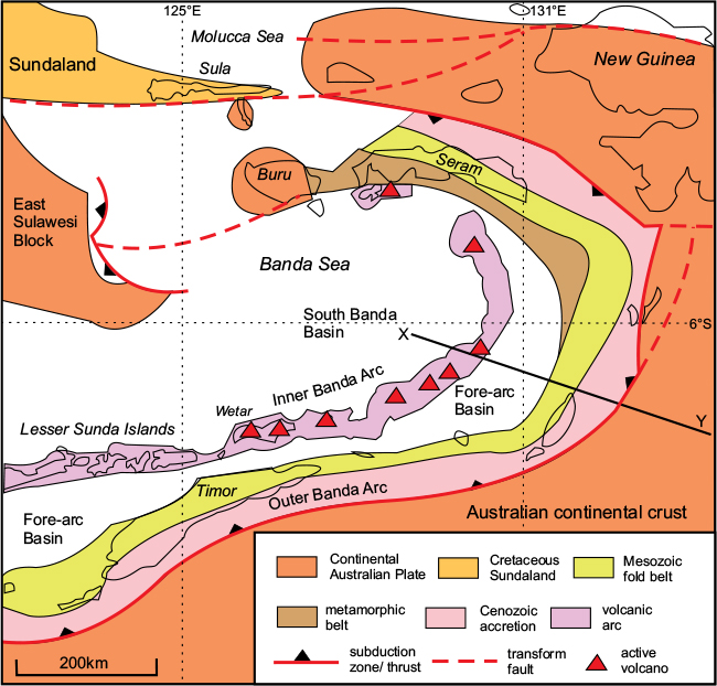
Figure 9.8 The Banda Arc system: main tectonic features. The inner Banda Arc is the presently active volcanic arc; the outer Banda Arc consists of an inner Mesozoic fold/thrust belt and an outer zone of Cenozoic accretion. The subduction zone defines the present surface boundary of the Australian continental plate, part of which has been subducted. After Darman, 2014
3The Ophiolite Belt. Here, oceanic crust of the former Tethyan Ocean has been thrust northwards onto the passive margin of the Australian continent.
4The Metamorphic Belt. This zone consists of low-grade schists derived from the Carboniferous to Jurassic sedimentary cover of the Australian continental platform. The zone wedges out southwards, and is absent at outcrop along the line of section of Figure 9.9.
5The Fold/thrust Belt. This zone is divided into an inner part consisting of imbricated Cretaceous to Cenozoic deep-water sediments, and an outer of Mesozoic platform sediments, both derived from the Australian Plate.
6The Foreland Basin. This zone contains a thick pile of recent sediments on the outer edge of the Australian platform.
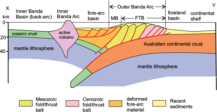
Figure 9.9 Schematic cross-section through the Banda Arc. Section is along the line X–Y on Figure 9.8. Note that the fore-arc basin is extensional and the outer arc compressional. FTB, Fold-thrust belt; MB, Ophiolite Belt. After Darman, 2014.
Tectonic interpretation
The Outer Banda Arc, as seen for example on Timor and Seram, is an accretionary complex, where the older rocks are situated on the inner side of the arc, and the younger on the outer side (Fig. 9.9). The complex is interpreted as a set of successively older and deeper crustal slices thrust backwards up onto the Australian continent as it is subducted beneath the Eurasian Plate. The main phase of contractional deformation occurred in the late Miocene, when the main continental collision occurred. The structure has been imaged seismically across the line of section X–Y in Figure 9.8. The fore-arc basin here is extensional, which may be the result of the late roll-back of the subducting slab. The volcanoes in the inner arc in this sector are shown rising directly from the ocean floor, which here is between 4km and 6km deep.
The origin of the Banda Sea Basin has been the subject of some debate: it has been interpreted as the result of back-arc spreading, in common with many of the arc systems around the Pacific rim; this would have occurred before the Australian continent came into contact with the arc. However, the shape of the arc must also have been influenced in part by the southward bending of the northwestern promontory of Australia as it came into contact with Eurasia, as illustrated by comparing Figures 9.7A and B. This would have resulted in the shape of the northern sector of the arc becoming much tighter, and assuming a more east–west orientation.
The Celebes and Sulu Seas
The most complex part of the Southeast Asian region of the Neogene orogenic belt is bounded in the west by Borneo; in the northeast by the island of Mindanao at the southern end of the Philippines Archipelago; and in the southeast by the island of Halmahera (Fig. 9.10). About 1150km from north to south and 850km across, it includes the strangely shaped island of Sulawesi discussed earlier, and the oceanic area to its north, which is divided into the Celebes Basin and the Sulu Basin, separated by the NE–SW-trending Sulu Ridge. These basins are bounded to the east by the Philippine Ridge, which continues south from Mindanao as a submerged feature to Halmahera. On the northwest side of the Sulu Sea are two further ridges, the Cagayan Ridge and the Palawan Ridge, connecting the northeast end of Borneo (Sabah) to the Philippines.
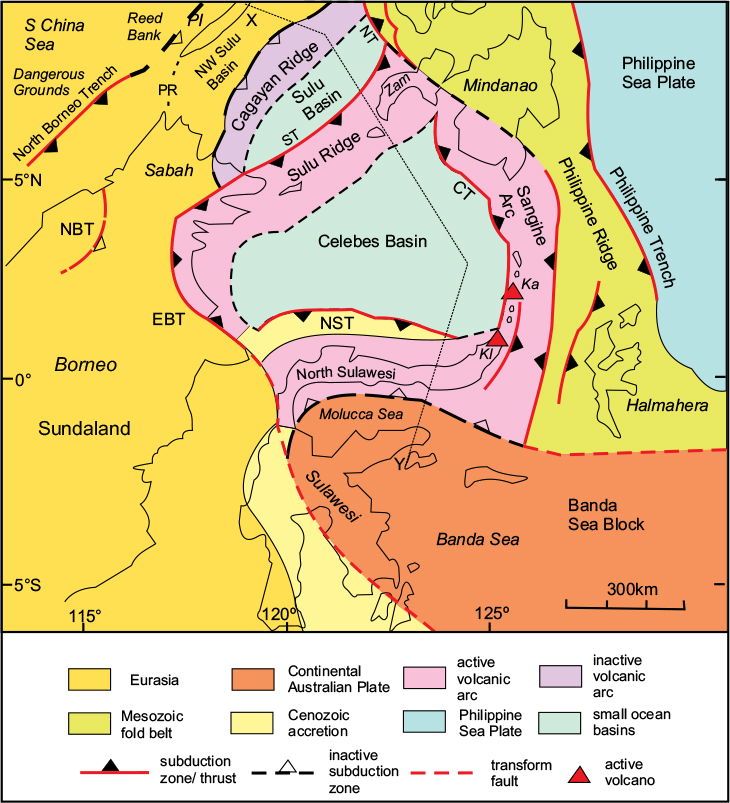
Figure 9.10 Main tectonic features of the Celebes Basin and surrounding area. CT, Cotabo Trench; EBT, East Borneo Thrust; Ka, Karangatan Volcano; Kl, Klabat Volcano; NBT, N Borneo Thrust; NST, North Sulawesi Trench; NT, Negros Trench; PI, Palawan Island; PR, Palawan Ridge; ST, Sulu Trench; Zam, Zamboanga. After Rangin et al., 1991.
The whole island of Sulawesi is mountainous: much of the main north–south central ridge of West Sulawesi is over 3000m in height. The most prominent peak on the ridge, Pantemano, is 3455m in height. This mountain ridge curves round into an east–west orientation along the narrow North Sulawesi peninsula, which also contains a central spine with several peaks over 2000m high. At its eastern end, this ridge continues offshore, bending round into a north–south-trending chain of small islands, the Sangihe Islands, situated along a submarine ridge that ends at southern Mindanao in the Philippines. There are thirteen volcanoes along this North Sulawesi–Sangihe Arc: nine on North Sulawesi and four on the Sangihe Arc. Klabat Volcano, at the northeast tip of North Sulawesi, is an impressive peak rising to 2022m in height. However, the most active volcano in the whole arc in recent years has been Karangetang, on the small island of Api Siau, about 140km north of Mindanao.
The Sulu ridge is part of the Sulu volcanic arc, on the northwest side of the Celebes Basin. This mostly submarine ridge follows a chain of islands, the Sulu Islands, ending in the Zamboanga promontory in the Philippines to the northeast. At its southwest end, the Sulu Arc curves southwards through northeast Borneo. There is only one active volcano, Jolo, in the Sulu Islands chain, and a single volcano in Northeast Borneo, Bombolai, which may still be active, although there are no historical records of its eruption.
Another volcanic arc, situated on the northeastern side of the Sulu Basin, is known as the Cagayan Ridge. This ridge extends from northeastern Borneo to the island of Panay in the Philippines and is wholly submerged except for two small islands, both named ‘Cagayan’, at each end of the ridge. There is no active vulcanicity on this ridge now.
A fourth volcanic arc, now also inactive, lies further northwest and consists of the long island of Palawan together with a group of small islands to its northeast. This ridge lies within the South China Sea Block, which is part of the Eurasian Plate.
Plate-tectonic setting
This complex region lies at the intersection of three large plates: Eurasia to the northwest, the Philippine Sea to the east, and Australia to the south (Fig. 9.10). At its core are two oceanic basins: the Sulu Basin in the north and the larger Celebes basin to the south. At the eastern margin of the region, transecting both oceanic basins, is the Philippine Orogenic Belt, which is bounded on both sides by active subduction zones: the Philippine Trench on the eastern side, where the Philippine Sea Plate is being subducted beneath the Philippine Ridge; and the Negros and Cotabo Trenches on the western side.
The northern margin is the southeastern edge of the South China Sea Block, which forms part of the Eurasian Plate. To the west is the large island of Borneo, which by the Neogene also formed part of Eurasia, and to the south is the Banda Sea Block which, as described earlier, formed part of the Australian Plate until the beginning of the Miocene. Traversing this region from north to south, eight separate tectonic zones have been recognised: the South China Sea Block; the Palawan Ridge; the Northwest Sulu Basin; the Cagayan Ridge; the Sulu Basin; the Sulu-Zamboanga Ridge; the Celebes Basin; and the North Sulawesi–Sangihe Arc. Figure 9.11 gives a cross-section through these zones.
The South China Sea Block
This area, wholly submerged beneath the South China Sea, is known as the Dangerous Grounds in the south and the Reed Bank in the north. Drilling has revealed that the Mesozoic cover of the Eurasian Plate in the Reed Bank area had been disrupted by extensional block faulting during the Palaeogene, before being covered by undeformed Neogene sediments.
The Palawan Ridge
The Reed Bank Block is bounded on its southeastern side by the Palawan Trench, interpreted as the now inactive subduction zone along which the Eurasian passive margin formerly descended beneath the oceanic plate to its south. The Palawan Ridge, consisting of imbricated Palaeogene to early Neogene deposits, represents the accretionary prism formed during this subduction process.
The Northwest Sulu Basin
This narrow marine trough between the Palawan and Cagayan ridges marks the remnants of the oceanic basin that formerly separated the Reed Bank Block from the volcanic arc of the Cagayan Ridge.
The Cagayan Ridge
This mostly submerged ridge consists of andesitic and basaltic volcanic material of early Miocene age (c.22–15Ma) and represents a now extinct volcanic arc.
The Sulu Basin
This marine basin, interpreted as a back-arc basin to the Cagayan subduction zone, consists of oceanic crust of early Miocene age. On the southeast side of the basin is the Sulu Trench, along which oceanic crust of the Sulu Basin is being subducted beneath the Sulu Ridge. The Sulu Trench connects to the southwest with the active East Borneo Thrust, and to the northeast with the Negros Trench, which forms part of the western boundary of the Philippine Ridge.
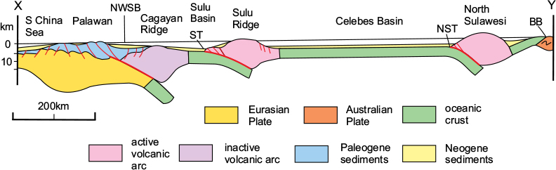
Figure 9.11 Simplified cross-section of the Sulu–Celebes area. Section is along the line X–Y on Figure 9.10. Note that the deformed sedimentary unit shown in blue also includes some early Neogene material. BB, Banda Sea Block; NST, North Sulawesi Trench; NWSB, Northwest Sulu Basin; ST, Sulu Trench. After Rangin et al., 1991.
The Sulu–Zamboanga Ridge
This is a younger volcanic arc than the Cagayan, consisting mostly of volcanic material of Pliocene to Pleistocene age. However, there are only two active volcanoes on the ridge now, one (Jolo) on the Sulu Islands and a second on the Zamboanga peninsula in the Philippines. The Zamboanga sector of the arc also contains Miocene volcanics and is situated on pre-Cenozoic basement.
The Celebes Basin
The oceanic crust of the Celebes Basin is of mid-Eocene age or older, and the southeast side of the Sulu Ridge is interpreted as a passive margin. The magnetic anomaly pattern is oriented NE–SW, indicating that the crust of the marine basin spread southeastwards to be subducted beneath North Suluwesi. The basin may have originated as a result of back-arc spreading as the subduction zone at the margin of the Banda Sea Block retreated southwards, before the continental part of the Australian Plate made contact in the mid-Miocene.
The North Sulawesi–Sangihe Arc
This ridge consists of an accretionary prism resulting from the north-westwards subduction of the oceanic crust of the Molucca Sea prior to the mid-Miocene collision between Australia and Sundaland. The subduction zone fringing the ridge on its southern side is now inactive, but the North Sulawesi Trench on the northern side of the arc is currently active: volcanic activity took place in North Sulawesi during the early Miocene and a more recent phase commenced in the late Miocene. Three of the 13 volcanoes on the arc, including Karangetang, are considered to be still volcanically active.
Tectonic history
The Banda Sea Block collided with the southern margin of the Celebes Basin in Central Sulawesi at the beginning of the mid-Miocene (c.16Ma ago). Further convergence between Australia and Eurasia first induced rapid subduction along the Cagayan Trench in the north, resulting in the closure of the oceanic part of the South China Sea Plate and the development of the Cagayan Volcanic Arc. Between 15Ma and 10Ma ago, the Sulu Basin commenced subduction beneath the Sulu Ridge and was followed in the mid- to late Miocene by the southwards subduction of the Celebes Basin beneath the North Sulawesi–Sangihe Arc. Both oceanic basins are still being subducted along the Cagayan and Sulu Trenches. These basins are also being subducted eastwards beneath the Philippine Ridge via the Negros and Catabo Trenches, while on their western side, the subduction zones terminate against a thrust in Sabah, and a transform fault through central Sulawesi.