The Western Pacific Rim
The circum–Pacific orogenic belt, often called the ‘Pacific Ring of Fire’, consists of two distinct halves: the western, much of which is represented by oceanic islands and island arcs, and the eastern, which follows the western margins of the North and South American continents for most of its length, and is discussed in the following chapters. The southern end of the western circum–Pacific belt is at the southwest extremity of the South Island of New Zealand, and the orogenic belt proceeds from there along a complex series of arcs and island chains to New Guinea, the Philippines and Taiwan (Figs. 10.1, 10.2). From Taiwan, the Ryukyu Island Arc connects to Japan, which in turn links up with the Kamchatka Peninsula via the Kurile Island Arc. The last part of the chain is the Aleutian Arc, which connects Siberia with Alaska. A separate branch of the system forms a wide loop through the Mariana Island Arc, separating the Philippine Sea from the Pacific. Older parts of the orogenic belt are also present on mainland Asia, but are now separated from the present-day active belt by a series of back-arc basins.
Figure 10.1 Volcanic arcs of the Western Pacific Rim. © Shutterstock, from NASA image.
The geological history of the circum–Pacific belt commenced with the supercontinent of Pangaea in the Permo–Triassic, when southern and eastern Asia were bordered by the ancestral Pacific Ocean Plate. Throughout the later part of the Mesozoic Era, various continental blocks broke away from Gondwana and were added to the Asian margin. Several of these, such as Cimmeria, North China and South China, have already been discussed in the preceding chapters. A succession of back-arc basins then formed during the Cenozoic, mainly as a result of trench roll-back, giving rise to the present-day system of arcuate Neogene belts, isolated from the continental margin.

Figure 10.2 Active arc systems of the Western Pacific Rim. An, Anchorage; Bis, Bismarck Plate; CI, Commander Islands; Hal, Halmahera; Ja, Japan; Lu, Luzon Arc; NG, New Guinea; Pal, Palau; Sol, Solomon Plate. After Leat & Larter, 2003.
The Cenozoic mountain belt of New Zealand’s South Island forms an impressive chain of mountains, 500km long and up to 160km wide, known as the Southern Alps, which form the central spine of South Island. The highest peak in the range, Mount Cook, is 3753m in height. The Southern Alps belt forms the western boundary of the Pacific Plate, and the southern tip of South Island links to the East Pacific ocean ridge via the MacQuarie Ridge, formerly regarded as a transform fault, although there is now thought to be a limited degree of convergence across it (Fig. 10.2). The mountain belt continues northwards through North Island as a greatly reduced narrow chain, also 500km long but much narrower, continuing the NE–SW trend to the end of the East Cape Peninsula.
Plate-tectonic context
New Zealand sits astride two tectonic plates: the Australian Plate to the west and the Pacific Plate to the east (Fig. 10.3). The plate boundary on South Island is the Alpine Fault, which runs along the west coast from Fjordland in the southwest, northeastwards to the north end of the island, where it divides into several branches. The main branch exits South Island north of the City of Christchurch, and continues northwards along the east side of North Island as a subduction zone, the Hikurangi Trench.
The southern end of the Alpine Fault is replaced by another subduction zone, the Puysegur Trench, which continues southwards along the west side of the mostly submerged Macquarie Ridge for about 400km. Along this sector of the plate boundary, it is oceanic crust of the Australian Plate that is being subducted, whereas further south along the Macquarie Arc, the Pacific Oceanic crust is being subducted beneath the Australian Plate. The Macquarie Arc meets the East Pacific mid-ocean ridge at the southwestern corner of the Pacific Plate.
Along the Hikurangi Trench, oceanic crust of the Pacific Plate is being subducted beneath North Island, which belongs to the continental Australian Plate. At the northeast end of North Island, the subduction zone continues as the Kermadec Trench, where oceanic Pacific Plate is being subducted beneath the Kermadec Arc. Both the Kermadec and North Island sectors are volcanically active: the six islands of the Kermadec group are volcanic, and the arc also contains many submarine volcanoes. North Island contains the Taupo volcanic zone, which is responsible for the famous hot springs and geysirs of Rotorua and the Tongariro volcanoes.
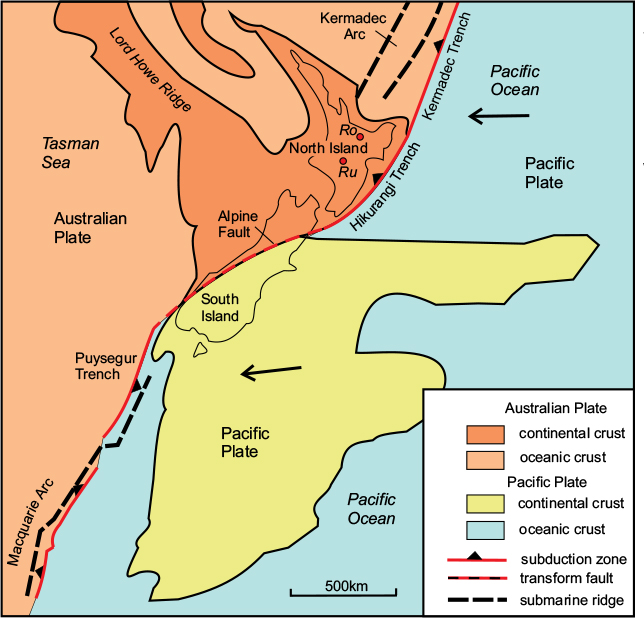
Figure 10.3 Plate-tectonic setting of the New Zealand region. Note that the plate boundary between the Australian and Pacific plates is a subduction zone east of North Island and also to the north and south of New Zealand, but is a transform fault through South Island with a component of convergence across it. After Coates, 2002.
The islands of New Zealand may be subdivided into five distinct tectonic units: the West Coast Province; the Volcanic Arc; the Older Torlesse Zone; the Younger Torlesse Zone; and the late Cretaceous–Cenozoic cover (Fig. 10.4).
The West Coast Province occupies a narrow belt, less than 100km in width, along the west coast of South Island, on the western side of the Southern Alps. It is bounded by the Alpine Fault along most of its length until the fault leaves the coast in Fjordland. South of this point, the rocks of the West Coast Province make up the southernmost part of the mountain chain. This tectonic zone consists of Precambrian and Lower Palaeozoic basement rocks of Gondwanan origin belonging to the Australian Plate. These Australian basement rocks also underlie North Island and continue westwards as a submarine platform beneath the Tasman Sea to link up with northeastern Australia. The New Zealand portion of this basement region rifted away from the Australian margin during the Cretaceous as the Tasman Sea basin opened up.
The Volcanic Arc
Immediately east of the west coast basement is a belt of volcanic rocks, including ophiolites, formed during Carboniferous to Jurassic times. In South Island, this zone is present only in the south and northwest of the island; between it is cut out by dextral displacement on the Alpine Fault. In North Island it continues as a 100km-wide belt along the west coast as far as Aukland. The volcanic arc was situated offshore along the eastern side of Gondwana, and resulted from the subduction of oceanic crust belonging to the ancestral Pacific Plate.
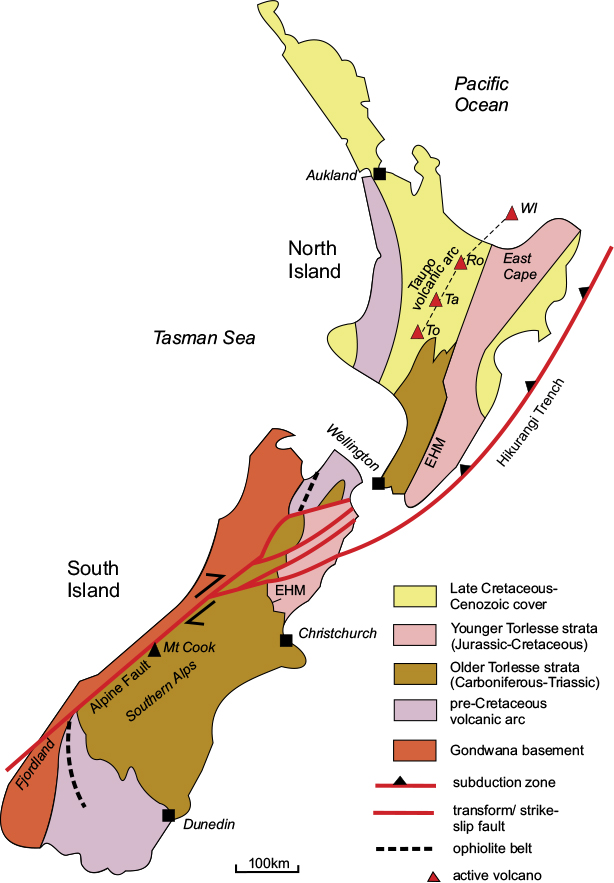
Figure 10.4 Principal tectonic features of New Zealand. EHM; Esk Head Melange; Ro, Rotorua; Ta, Taupo; To, Tongariro; WI, White Island. After Coates, 2002.
The Older Torlesse suite of rocks occupies the whole of the central part of South Island east of the Alpine fault, from Dunedin in the south to Christchurch, from where they extend in a narrow belt nearly to the north coast. They also occupy a smaller area in the southern part of North Island. The suite consists of a sequence, several tens of kilometres thick, mainly of greywackes and associated deep-marine sediments of Permo-Triassic age; these were deposited in submarine fans by turbidity currents flowing down the continental slope off the eastern margin of Gondwana. The western part of these Older Torlesse strata, close to the Alpine Fault, was uplifted to expose the metamorphosed lower parts of the sequence, known as the Haast Schist, during the First Rangitata Orogeny in the mid-Jurassic.
The Younger Torlesse Zone
The younger Torlesse suite, which occupies the northeastern part of South Island and the eastern part of North Island, consists of very similar sedimentary rocks to the older suite, but ranges in age from mid-Jurassic to mid-Cretaceous. They are separated from the Older Torlesse Zone by a narrow belt of disrupted sedimentary rocks known as the Esk Head Mélange. This belt represents a tectonic discontinuity formed when the older and younger parts of the accretionary complex were thrust together during the Second Rangitata Orogeny in the mid-Cretaceous.
The post-orogenic cover
Un-deformed sedimentary and volcanic deposits ranging from late Cretaceous to Recent form small sedimentary basins in South Island and cover a large part of North Island. Lavas and associated pyroclastic deposits originating from the active volcanoes of the Taupo Volcanic Arc are an important feature of North Island.
Tectonic History
Subduction along the eastern margin of Gondwana from late Carboniferous to Triassic times gave rise to a thick sequence of Older Torlesse strata, which were deposited on oceanic crust, then compressed and uplifted into a landmass during the First Rangitata Orogeny in the mid-Jurassic. A further period of accumulation of deep-marine strata ended with the Second Rangitata Orogeny in the mid-Cretaceous, which resulted in the formation of a wide accretionary complex encompassing almost all of New Zealand, together with much of the adjoining continental shelf. In the later Cretaceous, widespread extension and rifting resulted in the opening of the Tasman Sea basin, and the isolation of the various island landmasses that eventually became New Zealand.
During the Neogene Kaikoura Orogeny, subduction along the Hikurangi and Kermadec Trenches resulted respectively in the Taupo and Kermadec volcanic arcs. As can be seen in Figure 10.3, the convergence direction across the Hikurangi Trench is E–W, whereas on South Island, it is ENE–WSW, only slightly oblique to the Alpine Fault, which therefore is a transpressive structure with a large component of dextral strike-slip motion, responsible for the 500km displacement of the margin of the volcanic arc outcrop. The convergence rate is about 30mm/a in the south, varying to over 40mm/a in the north. Both North and South Islands are subject to intense and often highly destructive seismicity. Shallow earthquakes occur almost everywhere, whereas deep-focus earthquakes are concentrated on North Island and northernmost South Island due to the west-dipping Hikurangi subduction zone.
New Zealand to New Guinea
Northwards from New Zealand, the circum-Pacific orogenic belt lies entirely within the Pacific Ocean, through a series of intra-oceanic volcanic arcs, until it reaches New Guinea (Fig. 10.2). For the first 1000km it follows the submerged Kermadec ridge to the Tonga Archipelago, after which it turns sharply south-westwards to join the southern end of the Vanuatu Arc, and from there via the Solomon and New Britain Arcs to reach the northeastern coast of New Guinea.
The Tonga–Kermadec Arc
The Kermadec Arc is the northern extension of the Taupo volcanic zone of New Zealand’s North Island, discussed previously. The arc includes six volcanic islands in the Kermadec Group together with about 30 submarine volcanoes, or seamounts. Only two of the volcanoes are known to be currently active. The volcanic ridge is accompanied by a trench on its eastern side, which reaches depths of up to 8km. The 800km-long Tonga sector of the Arc consists of 16 islands situated on a broad ridge containing 16 volcanoes, 12 of which are known to have been active historically (Fig. 10.5). On the eastern side of the ridge is the Tonga Trench, the southern end of which reaches a depth of nearly 11km. To the west of the Tonga Ridge is the older, inactive, Lau Ridge, formed during Eocene to Miocene time, which has a more north–south trend and ends at the Fiji Platform. The two ridges are separated by the narrow, elongate, Lau back-arc basin, which opened over the last 6Ma, after which the Lau Ridge ceased to be active.
Despite the fact that for much of their lengths these volcanic arcs only occasionally break the surface, they are no less impressive as mountain ranges than their continental counterparts. The ocean floor from which they rise is typically between 2000m and 4000m in depth, and, measured from the deep-ocean trenches, a vertical relief of over 10,000km to some of the higher volcanic summits is not uncommon, making these systems comparable in scale to the Himalayas.
Tonga to Vanuatu
The Tonga Trench curves around the northern end of the Tonga Ridge, at the northern end of the Lau Basin (Fig. 10.5). It is replaced by the sinuous Vitiaz Trench Lineament, now inactive but active from Eocene to Miocene times, which forms the boundary between the Pacific Plate to the north and the North Fiji back-arc basin to the south.
The Lau Ridge ends on the eastern side of the Fiji Platform, on which the Fijian Islands are situated. Fiji itself consists of two large and several smaller islands, and the Fiji Platform is a large area, now part of the Pacific Plate, approximately 450x200km in extent, with an ocean depth of less than 500m. The crust here is estimated to be c.20km in thickness, which has prompted speculation that the platform may represent a thinned piece of the Australian continent, now separated from it by the South Fiji Basin. Alternatively, Fiji may have acquired an unusually large volume of igneous material from the opposed subduction zones on either side.
The south side of the actively spreading North Fiji Basin is defined by the wide curve of the Hunter Fracture Zone, which links the north end of the Lau Ridge with the southern end of the Vanuatu Arc. The submerged Hunter Ridge north of, and parallel to, the Hunter Fracture Zone is believed to be the site of subduction of oceanic crust generated in the North Fiji Basin in the last 5Ma or so, but the fracture zone itself appears now to be a transform fault, being approximately parallel to the northeasterly convergence direction of the Australian Plate.
The Vanuatu Arc
The Vanuatu Ridge is a broad, submerged volcanic ridge 1500km long and up to 200km wide, and the Vanuatu Island chain is spread out over 1300km along it (Fig. 10.5). The main NW–SE ridge is Y-shaped and divides in the central part of the archipelago, a more NNW–SSE branch continuing northwards to include the Santa Cruz Islands, which are part of the Solomon group. The former name for Vanuatu is the New Hebrides, and the trench that follows the ridge on its western side is still referred to as the New Hebrides Trench.
The archipelago consists of 13 larger islands and over 60 smaller islands and rocky outcrops. Twenty-four volcanoes are recorded in the Vanuatu Arc, 12 of which have been active in recent years. The largest Island, Espiritu Santo, contains igneous rocks of Eocene to Miocene age resting on Gondwana basement. The ridge rises from an ocean depth of over 3km on its eastern side and over 5km in the New Hebrides Trench to the west; the highest point on it is the 1810m-high volcanic peak of Tabwemasana on Espiritu Santo.

Figure 10.5 Plate-tectonic framework of the Tonga–Fiji–Vanuatu region. ES, Espiritu Santo; SCI, Santa Cruz Islands; VA, Vanuatu archipelago. After Segev et al., 2012.
The arc is strongly active seismically due to the ongoing subduction of oceanic crust belonging to the Australian Plate beneath the North Fiji Basin. Convergence rates are in the range 90–120mm/a, except in the central sector, where they are much reduced due, it is thought, to the intersection of the trench with a submerged ridge. The effect of this concurrence appears to have caused the uplift of the outer ridge and the creation of a narrow basin between the outer and inner arcs east of Espiritu Santo.
The Solomon Arc
At the northern end of the Vanuatu Ridge is a small group of islands, the Santa Cruz Islands, which are part of the Solomon Islands (Fig. 10.5). From there, the seismically active belt bends abruptly into an east–west orientation. The trench here is known as the San Cristobal, or Solomon, Trench, and is accompanied on its northern side by a 200km-wide ridge containing the Solomon Islands archipelago (Fig. 10.6). This island group is an independent country consisting of six main islands and over 900 smaller ones extending over a distance of about 1500km. One of the largest islands is Guadalcanal, site of the famous Second World War battle.
There are three separate sectors of the Solomon Arc, each resulting from the subduction of different plates. The southeastern sector, containing the island of Guadalcanal, is the product of the subduction of the northward movement of oceanic crust of the Australian Plate beneath the Pacific plate. The central sector, centred on New Georgia, is the site of subduction of younger, more buoyant crust of the Woodlark Plate. Here the trench is indistinguishable as a topographic feature, and this part of the ridge exhibits lower relief. The northwestern sector is where oceanic crust of the Solomon Sea Plate is being subducted; the trench here is again well defined and the ridge contains the large, mountainous island of Bougainville. There are eight recorded volcanoes on the arc, but only four have been active historically.
New Guinea
This island consists of the two separate countries of Irian Jaya in the west and Papua New Guinea in the east, but is usually referred to as ‘New Guinea’ for geological purposes.
The plate-tectonic arrangement between the Solomon Arc and New Guinea is complex, with four separate small plates intervening between the Pacific Plate in the north and the Australian Plate in the south (Fig. 10.6). The Solomon Ridge continues westwards through the large island of New Ireland and the numerous small islands of the Bismarck Archipelago. Much of this broad, arcuate ridge on the north side of the Bismarck Sea is submerged, and it dies out westwards. It is the main component of the North Bismarck Plate and is defined on its northern side by a currently inactive plate boundary marking the former position of the circum-Pacific subduction zone. Its southern boundary consists partly of spreading axes and partly of transform faults, and is seismically active.
The South Bismarck Plate consists partly of oceanic crust belonging to the Bismarck Sea Basin and partly of the continental crust of New Britain and northeastern New Guinea. To the south of the South Bismarck Plate is the actively spreading Solomon Sea Plate. This oceanic plate is being subducted northwards beneath the South Bismarck Plate along the well-defined New Britain Trench, which is over 9km deep in places.
All three of these micro-plates are bounded along their southern sides by the long, narrow Woodlark Plate, which contains the mountainous spine of New Guinea. This belt of high mountains, containing several peaks over 4000m in height, divides eastwards into three separate ridges: a northern arm, which continues as the New Britain Arc; a central arm, which forms the Woodlark Ridge and contains the small Woodlark Island; and a southern arm, which continues the mountain spine along the southeastern promontory of Papua New Guinea and continues as the submarine Louisiade Ridge. The northern and central ridges are both southerly-convex arcs enclosing the Solomon Sea Basin. The southern arm is part of the Australian Plate.
The Woodlark Plate consists mostly of material accreted to the Australian margin during the Palaeogene. The central mountain range consists of Mesozoic metamorphic rocks folded and uplifted as a result of a collision between the Australian continental margin and a Miocene volcanic arc, and is fringed by a belt of obducted ophiolites along its northern side. The northern boundary of the Woodlark Plate east of New Guinea is the Woodlark Ridge, which forms the southern boundary of the Solomon Sea Plate, and is seismically active.
The southern half of the island of New Guinea is composed of Australian continental crust consisting of Precambrian basement together with the remnants of a Palaeozoic orogenic belt. The boundary between the Australian and Woodlark Plates on New Guinea is inactive, but its continuation eastwards is considered to be a spreading axis separating the two plates.

Figure 10.6 Small plates between the Solomon Ridge and Papua New Guinea. B, Bougainville; LR, Louisiade Ridge; NBT, New Britain Trench; NG, New Georgia; WI, Woodlark Island; WR, Woodlark Ridge. After Alataristarion 2006, via Wikimedia Commons.
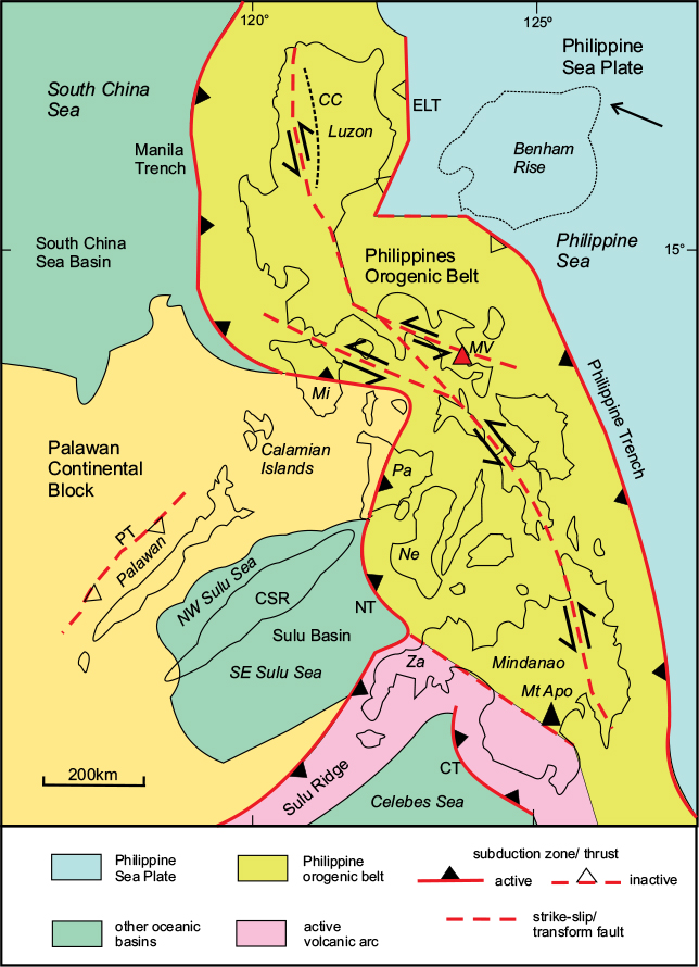
The Philippines
The circum-Pacific orogenic belt turns northwards from western New Guinea through the island of Halmahera and along the Philippine Ridge to the southern end of the Philippines (see Fig. 10.2). The Philippines consist of over 7000 islands extending in a roughly north–south belt over 2000km long and up to 500km wide along the Western Pacific rim (Fig. 10.7). The two largest islands are Luzon in the north, and Mindanao in the south. Both these islands contain mountain ranges with many peaks over 2000m in height, the highest being the 2954m volcanic peak of Mt. Apo in Mindanao. The smaller islands of Mindoro and Panay in the centre of the archipelago are also mountainous. However, most of the mountain groups are quite isolated, and there is no clearly defined mountain spine running through the island chain.
The Philippines is one of the most volcanically active sectors of the circum-Pacific belt, with about fifty active volcanoes and seamounts. These are arranged in two main arcs: a northern, running parallel to the Manila Trench subduction zone on the western side of the archipelago, and a southern, parallel to the Philippine Trench on the eastern side. Mayon (Fig. 10.8) in Luzon is the most famous of the active volcanoes. There are also groups of active volcanoes on the island of Negros, associated with subduction along the Negros Trench, and in southwestern Mindanao, belonging to the Cotabo Arc.
Tectonic summary
The Philippine Islands are framed by subduction zones on each side: the Manila, Negros and Cotabo Trenches on the western side and the East Luzon Trough and Philippine Trench on the eastern (Fig. 10.7). Only the Philippine Trench is a major topographic feature, being over 10.5km deep at its deepest point. Both sets of subduction zones dip inwards beneath the Philippines, which is also split down the centre by a major sinistral strike-slip fault system. The combination of E–W compression and sinistral strike-slip indicates that the Philippine belt is essentially transpressional: the Philippine Plate is converging with Eurasia in a northwesterly direction with an estimated rate of convergence along the Philippine subduction zone of 150mm/a.
Figure 10.7 Tectonic framework of the Philippines. BR, Benham Rise; CSR, Cagayan-Sulu Ridge; CT, Cotabo Trench; ELT, East Luzon Trough; MT, Manila Trench; NT, Negros Trench; PT, Palawan Trough. Geographic names: CC, Cordillera Central; Mi, Mindoro; MV, Mayon volcano; Ne, Negros; Pa, Panay; Za, Zamboanga. After Morrison, 2014.

Figure 10.8 Mayon Volcano, Luzon. This 2462m peak is the most famous of the active volcanoes of the Philippines and last erupted in 2014. © Shutterstock, by suronin.
The Philippines commenced its geological history as a volcanic arc along the Asian margin during the Cretaceous. Subsequent retreat of the subduction zone led to the development of the extensional South China Sea Basin. The southern part of the South China Sea Basin consists of the mostly submerged Palawan continental block, containing the NE–SW ridge of Palawan and the Calamanian Islands. This block has impinged on the western margin of the Philippine belt, causing a prominent bend in the subduction zone in the central part of the archipelago.
The southern part of the Philippine Belt is complicated by the intersection of the active Sulu volcanic arc with the western margin of the belt. Here oceanic crust of the Sulu Basin is being subducted eastwards beneath the Negros Trench as well as southeastwards beneath the Sulu Ridge. Another ocean basin centred on the Celebes Sea, south of the Sulu Ridge, is being subducted beneath the Cotabo Trench west of Mindanao. The tectonic history of the Celebes and Sulu Basins, together with the inactive Palawan and Cagayan arcs, was discussed in the previous chapter (see Figs 9.10 and 9.11).
The sinuous shape of the Philippine Belt and the associated deviation of the strike-slip fault system are attributed to the impingement of the buoyant Palawan block in the central part of the belt. This has caused anti-clockwise rotation of the islands on the north side of the projecting wedge and clockwise rotation of those on the south side. The boundary between the Palawan Block and the Philippine Belt is represented by a fold-thrust belt, exposed on Mindoro and other islands to the immediate south of it, in which the Philippine Belt rocks are overthrust towards the west over the Palawan Block.
The eastern margin of the Philippine Belt is simpler; the northern sector is bounded by the East Luzon Trough, which is now an inactive subduction zone. This zone is offset along a transform fault to continue as the active Philippine Trench.
The basement of the Philippine Belt is similar to that of the Palawan Block and consists of Cretaceous volcanics and ophiolites originating on the Asian margin. These are overlain by Eocene to Oligocene volcanics, carbonates and clastic sediments. The older rocks, which include metamorphosed basement units, are exposed in the Cordillera Central mountain range in western Luzon. The uplifted older rock outcrops are separated by basins containing Neogene sediments and volcanics.
Tectonic history
Volcanism began along the Asian margin during the Cretaceous, forming a volcanic arc which then split from the Asian margin with the opening of the South China Sea Basin in the Eocene. At about the same time, the Philippine Sea Plate separated from the Pacific Plate. Later in the Eocene, the spreading South China Sea Plate began to subduct eastwards beneath the Philippines along the Manila Trench, forming a Palaeogene volcanic arc. The Celebes Sea Basin also opened during this period.
During the Miocene, the Palawan Block collided with the western margin of the belt, causing the northeastern end of the block to underthrust the Philippine Belt on Mindoro and Panay. Subduction was temporarily halted along the western margin of the belt, but later in the Miocene, the Sulu Sea Basin opened, subduction began along the Cotabo and Negros Trenches, and resumed along the other sectors, continuing into the Pliocene. However, at present, active subduction appears to be restricted to the Manila, Philippine, Negros and Cotabo sectors.
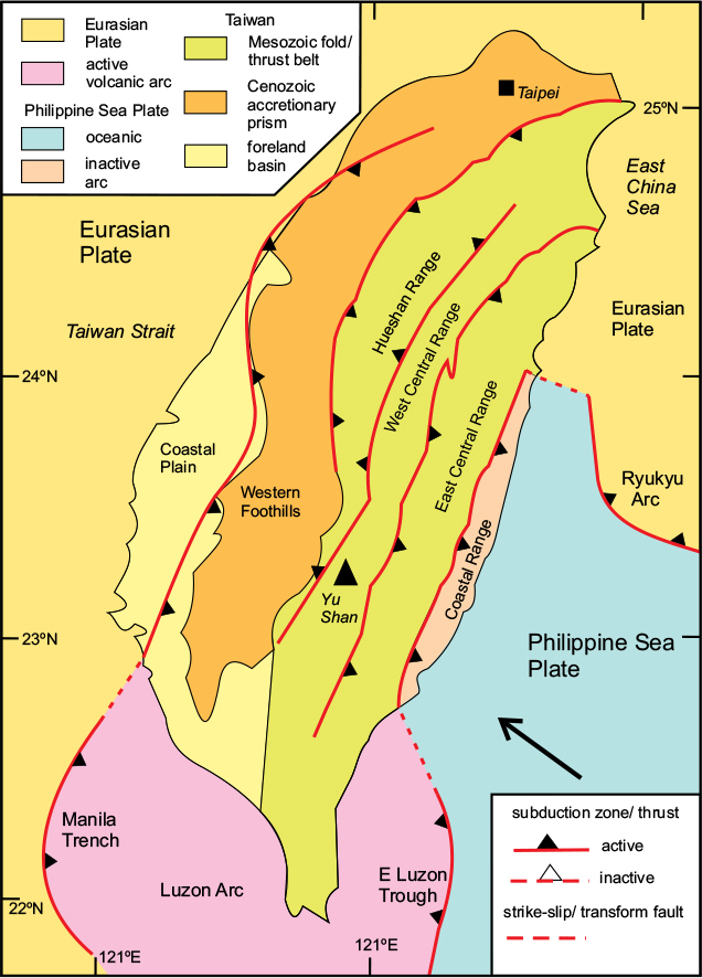
The Luzon Arc and Taiwan
The Luzon Arc
The circum-Pacific orogenic belt continues northwards from Luzon in the Philippines for 400km along the Luzon Volcanic Arc to meet the southern end of Taiwan (see Fig. 10.2). There are five active volcanoes along the southern sector of the Luzon Arc, which occupies a poorly defined, mostly submerged, ridge becoming indistinct south of Taiwan. The east-dipping Manila Trench subduction zone, where Eurasian crust is descending beneath the Luzon Ridge, defines the western side of the ridge but is not readily apparent topographically.
The East Luzon Trough is a more prominent topographic feature that follows the eastern side of the ridge up to the southern promontory of Taiwan. This west-dipping subduction zone marks the plate boundary between the Philippine Sea and Eurasian Plates, and is replaced in eastern Taiwan by an east-dipping onshore thrust (Fig. 10.9).
Figure 10.9 Main tectonic elements of Taiwan. After Central Geological Survey of Taiwan; and Lallemand et al., 2002.
Taiwan
The greater part of the island of Taiwan is composed of a central mountainous spine, the Taiwan Shan, which runs the whole 380km length of the island. Most of the mountain range is over 2000m in height, the highest peak being Yu Shan (Fig. 10.10), at 3997m.
The island can be divided into four main tectonic zones, from west to east: the Western Coastal Plain; the Western Foothills; the Central Highlands; and the (eastern) Coastal Range. The three western zones are part of Eurasia, whereas the Coastal Range is part of the Philippine Sea Plate (Fig. 10.9). The Western Coastal Plain is the stable margin of the Eurasian Plate and is the site of the present-day foreland basin. The Western Foothills represent the uplifted synorogenic accretionary prism, the western margin of which is an east-dipping thrust marking the edge of the Coastal Plain.
The Central Highlands consist of three separate thrust packages: the Hueshan, West Central and East Central Ranges, containing a series of thrust, folded and metamorphosed units involving Pre-Cenozoic basement together with an Eocene to Miocene sedimentary cover.
Figure 10.10 Yu Shan (Mt. Jade): the highest mountain in Taiwan. Shutterstock©elwynn.
The Coastal Range is the on-land continuation of the Luzon Arc, and is separated from the Central Highlands by a major east-dipping thrust representing the boundary between the Eurasian and Philippine Sea Plates. The convergence rate along this boundary is estimated at 80mm/a in a WNW–ESE direction. About two-thirds of the way along the eastern coast of Taiwan, this plate boundary turns abruptly eastwards, and then south-eastwards to become the Ryukyu Arc, discussed below. Subduction of oceanic crust has ceased beneath the main island of Taiwan and the stretched Eurasia continental crust is in contact with the now inactive Luzon Arc along the eastern Coastal Range. Convergence there is being accommodated along the set of thrusts that separate the main tectonic units. Except for some submarine volcanoes offshore, volcanic activity is now limited.
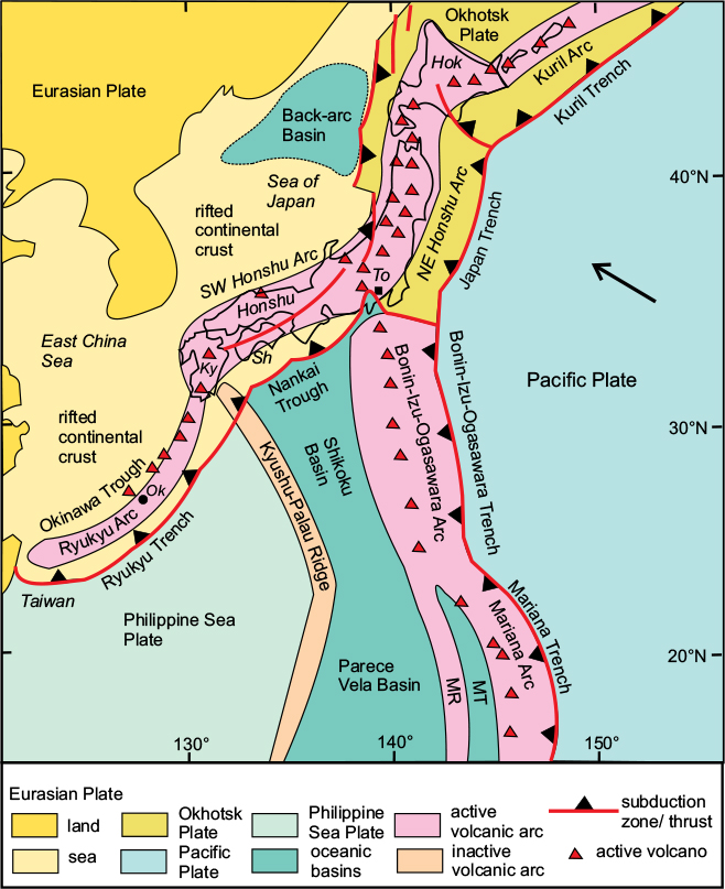
The Japanese Arc System
There are five separate elements making up the Japanese arc system. The main circum-Pacific orogenic belt includes, from south to north: the Ryukyu Arc, the SW Honshu Arc, the NE Honshu Arc and the Kuril Arc (Fig. 10.11). The fifth element is the Izu-Ogasawara, or Bonin, Arc, which meets the main belt in Central Honshu. The present configuration was established during the early Neogene when the opening of the Japan Sea separated the Japanese islands from Eurasia.
The Ryukyu Arc
This is the southernmost sector of the system, extending from Taiwan to Kyushu, a distance of 1000km. It consists of about 55 islands, some quite large – up to several tens of kilometres in length – and hilly, while others are flat coral atolls. The largest island is Okinawa, in the centre of the chain. The larger islands are all volcanic; there are five currently active volcanoes, all in the central and northern sectors of the chain.
The Ryukyu Arc in its present form dates back to the late Pliocene, about 2Ma ago, as a result of the subduction of the Philippine Sea Plate westwards beneath Eurasia. The arc consists of a partly submerged ridge, convex towards the Philippine Sea, the southern part of which is composed of deformed Mesozoic and Cenozoic basement similar to that of Taiwan, while the northern part is volcanic in origin. The ridge is bounded on its eastern side by the Ryukyu Trench, which is a marked topographic feature with a maximum depth of 7460m. The rate of subduction along the trench has been calculated at c.52mm/a. There is a much broader, but shallower, linear basin on the inner side of the ridge, known as the Okinawa Trough, which is interpreted as an extensional back-arc basin produced by slab roll-back of the subduction zone.
Figure 10.11 Main tectonic elements of the Japan arc system. MR, Mariana Ridge; MT, Mariana Trough. Geographic names: Hok, Hokkaido; Ky, Kyushu; Ok, Okinawa; Sh, Shikoku; To, Tokyo. After Taira et al., 2016.
The SW Honshu Arc
This arc extends for about 600km from the southern tip of the island of Kyushyu, through SW Honshu and Shikoku Island, to just west of Tokyo, where the Izu-Ogasawara ridge meets the coast. This part of Japan is hilly, with some peaks just short of 2000m in height along the southern side of the arc in Kyushu and Shikoku. The on-land sector of the arc here is around 200km in width. There is a single active volcano on the inner side of the arc; the outer part of the arc, including Shikoku Island, is interpreted as a fore-arc ridge.
The basement of the SW Honshu Arc consists of a series of accretionary prisms and thrust slices dating from Palaeozoic to Cenozoic in age, becoming younger south-eastwards. The arc is bounded on the outer side by the Nankai Trough, where oceanic crust of the Shikoku Basin, part of the Philippine Sea Plate, is being subducted beneath the arc. The Shikoku fore-arc consists of a series of basins separated by thrusts. On the inner side of the arc, the Japan Sea back-arc basin is situated on rifted Eurasian continental crust. Palaeomagnetic evidence has shown that the opening of this basin was achieved by the clockwise rotation of SW Honshu coupled with anti-clockwise rotation of NE Honshu.
The central part of Honshu, north of the city of Tokyo, is much more mountainous, with several ranges containing peaks over 3000m in height. This elevated area, where the SW and NE Honshu Arcs meet, is thought to result from a collision with the Izu-Ogasawara Ridge, and marks the western boundary of the Okhotsk Plate.
The NE Honshu Arc
This is over 700km long and extends in a NNE–SSW direction from Central Honshu to the northern tip of the island of Hokkaido. It contains two roughly parallel lines of Pleistocene to Present-day volcanoes, 17 of which are currently active. This sector of the arc consists of a basement similar to that of the SW Honshu Arc, with thrust packages separated by N–S-trending reverse faults. The on-land arc is bounded on the eastern side by the Japan Trench, along which the Pacific Plate is being subducted at a rate of 80–90mm/a. This region is extremely active seismically and there have been a number of very large earthquakes in recent years, including the notorious 2011 episode responsible for the damaging tsunami that destroyed the nuclear power plant at Fukushima.
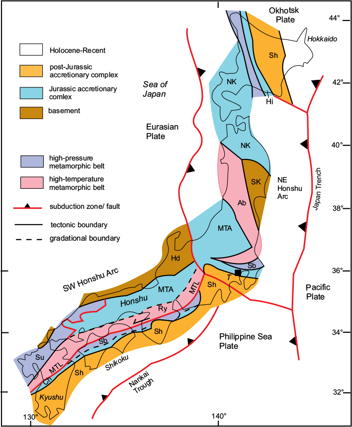
Tectonic structure of the SW Honshu Arc
Prior to the opening of the Japan Sea back-arc basin in the Miocene, the basement of the main Japanese islands formed part of the Asian mainland, and consists of a series of accretionary complexes attached to the Asian margin from late Palaeozoic times. The basement of the SW Honshu Arc is divided into a number of tectonic zones, each of which represents a composite accretionary package (Fig. 10.12). These are mostly separated by thrusts or steep faults, the most important being the Median Tectonic Line (MTL), which is a long-lived sinistral strike-slip fault active from Cretaceous times to the present day.
The tectonic zones are of three basic types: unmetamorphosed or weakly metamorphosed accretionary complexes; high-pressure, low-temperature metamorphic belts and low-pressure, high-temperature met-amorphic belts. These adjoining high-pressure and low-pressure metamorphic belts are the ‘paired metamorphic belts’ made famous by Akiho Miyashiro in the 1960s (Miyashiro, 1961), and were subsequently explained as the product of, respectively, deeply buried slabs of cool subducted crust, and sections of warm volcanic-arc crust. Paired belts developed during the Jurassic and again in the Cretaceous.
There are seven roughly parallel tectonic zones in the SW Honshu Arc (Fig. 10.12). On the inner (northwest) side of the MTL, from north to south, are: the Hida basement; the Suo High-Pressure Zone; the Mino-Tamba complexes; and the Ryoke Low-Pressure Zone. South of the MTL are: the Sanbagawa High-Pressure Zone; the Chichibu Complex and the Shimanto Complex.
The Hida Zone
This metamorphic terrain consists of granitic gneisses and amphibolite-facies metasediments ranging in age from Precambrian to Jurassic and considered to represent a block of Eurasian basement affected by mid-Mesozoic deformation and high-temperature metamorphism. The Hida rocks have been correlated with the Sino-Korean Block on the Asian mainland.
The Suo Zone
This high-pressure, low-temperature metamorphic zone consists of schists interpreted as a Permo-Triassic accretionary complex metamorphosed during the Jurassic. The Suo belt is restricted to the southern part of Honshu and Kyushu and is thrust beneath the overlying Mino-Tamba units.
The Mino-Tamba accretionary complexes
The wide zone identified as ‘Mino-Tamba’ in Figure 10.12 contains several thrust units in addition to the Mino-Tamba (sensu stricto), including the Akiyoshi and Ultra-Tamba accretionary complexes and the Maizuru ophiolite complex, and consists of oceanic sediments and volcanics ranging from Carboniferous to Jurassic in age and interpreted as Permian to Jurassic accretionary complexes. The zone is also represented in NE Honshu and Hokkaido, where it is known as the North Kitakami Zone, and can be traced northwards into the Sikhote-Alin Range on the Russian mainland.
The Ryoke Zone
This is a mid-Cretaceous high temperature–low pressure metamorphic belt developed from the accretionary complex of the Mino-Tamba Zone and has a gradational boundary with it. The equivalent units in NE Honshu and Hokkaido are known as the Abukuma and Hidaka Belts respectively.
The Sanbagawa Zone
This is a high-pressure–low temperature metamorphic unit that has experienced high strain due to its proximity to the Median Tectonic Line. It consists of oceanic crust and trench deposits of early Mesozoic age. The Sanbagawa and Ryoke are ‘paired’ metamorphic belts developed during the mid-Cretaceous event.
The Chichibu Zone
This is another accretionary complex similar to the Mino-Tamba units, containing sediments ranging from Silurian to Permian in age. It is separated by a fault from the Shimanto Zone on the south side but has a gradational boundary with the Sanbagawa Zone.
Figure 10.12 Tectonic zones of the Honshu Arcs. Low-P/High-T metamorphic zones: Ab, Abukuma; Ry, Ryoke. High-P/Low-T zones: Sb, Sanbagawa; Su, Suo. Accretionary complexes: Ch, Chichibu; Hi, Hidaka; MTA, Mino–Tamba; NK, North Kitakami; Sh, Shimanto. Foreland blocks: Hd, Hida; SK, S. Kitakami; MTL, Median Tectonic Line. T, Tokyo. After Kojima et al., 2016.
The Shimanto Zone
This is an accretionary complex of Cretaceous to Neogene age, which developed on the southeast side of the earlier accretionary complexes. A similar zone in Hokkaido is considered to be an extension of the same belt.
Tectonic history of the Honshu Arcs
The basement of the Honshu Arcs contains rocks ranging from mid-Precambrian to mid-Palaeozoic in age, similar to the Sino-Korean Block of the Asian mainland. From the Permian onwards, a succession of accretionary complexes developed as a result of the subduction of the Pacific oceanic plate beneath the Asian margin. The earlier packages (e.g. Mino-Tamba and Chichibu) were deformed and metamorphosed during the early Cretaceous Oshima orogeny, and were succeeded by a later complex (the Shimanto) which developed through the Cretaceous and Palaeogene and was deformed in a second event (the Mizuho orogeny) in the Miocene. The current phase of activity extended from the Miocene to the present and is responsible for the active volcanic arc and the Nankai accretionary prism developing on the outer side of the arc.
The Okhotsk Plate and the Verkhoyansk Belt
The Okhotsk Plate (or sub-plate) lies at the southwestern corner of the American Plate but has a slightly different movement direction and convergence rate from the main part of that plate. Its western boundary is the subduction zone lying west of NE Honshu, and extending northwards along the west side of Sakhalin Island. From there, the plate boundary links with the Verkhoyansk Fold Belt, which is a compressional fold belt formed by the late-Jurassic to early Cretaceous collision between the North American and Eurasian Plates (see Figs 10.1 and 10.2).
The Bonin-Mariana Arcs
This arc system (see Figs 10.1 and 10.11) extends from central Honshu southwards for 2800km to the island of Guam, where it is joined by two shorter arcs around the islands of Yap and Palau, eventually meeting the long north-south submarine ridge that ends at the western end of New Guinea. The northern (Japanese) sector is also known as the Izu-Ogasawara Arc. The arc system consists of a ridge with a deep trench on its outward side, and represents an intra-oceanic convergent margin where the Pacific Plate is being subducted westwards beneath the Philippine Sea Plate. The northern Bonin, or Izu–Ogasawara, Trench is over 10km deep near Honshu but becomes less obvious further south. The Marianas Trench, at over 11km deep, is one of the deepest parts of the global trench network.
The Bonin–Mariana arc system originated about 50Ma ago and resulted in a simplification of the circum-Pacific boundary, isolating the Philippine Sea on its inner side. From about 25Ma ago, back-arc extension opened up the Parece Vela Basin as the arc migrated eastwards, separating it from its original site along the submarine Kyushu–Palau Ridge. The northern part of this back-arc basin is now being subducted beneath SW Honshu along the Nankai Trough. The northern sector of the arc system is a broad submerged ridge, up to 200km wide, with only a few small islands, but hosts seven active volcanoes. The Mariana sector is more arcuate in shape, and convex towards the Pacific. A more recent back-arc basin, the Mariana Trough, has formed on the inner side of this arc, splitting the ridge into two parts. A further five active volcanoes occur in this southern sector.
The Kuril–Kamchatka Arc
This arc extends from the northeastern end of Hokkaido Island for about 1000km to the Kamchatka Peninsula in Russia (see Fig. 10.2). The island arc consists of a string of islands on a submerged ridge with a marked trench, the Kuril Trench, up to 10.5km deep on its outward side. The Sea of Okhotsk on the inner side of the arc is a Neogene back-arc basin. Vulcanicity on the Kuril arc commenced about 20Ma ago in the early Miocene, and there are about 40 volcanoes active at present. The Kamchatka sector of the arc contains another 29 active volcanoes whose activity commenced in the late Pliocene, and contains Kluchevskoi Volcano, at just under 5000m Eurasia’s highest active volcano.
The arc meets the Aleutian Arc at a triple junction west of the Commander Islands, where a transform fault continues northwards and the Aleutian Arc strikes eastwards. The Pacific Plate is being subducted northwestwards beneath the Kuril Arc at a rate of between 75mm/a in the south and 83mm/a in the north. The oblique nature of the convergence means that the stress along the arc is transpressional, with a sinistral strike-slip component.
The Aleutian Arc
This is a broad arc, about 3400km long, convex towards the Pacific Ocean, with the Bering Sea Basin on its inner side. The arc extends from its junction with the Kuril–Kamchatka Arc to Alaska; the last 1000km lie along the Alaskan Peninsula to the city of Anchorage, where it meets the northern end of the Western American orogenic belt system – the subject of the next chapter.
The arc is situated on a broad ridge containing 14 large islands together with a large number of smaller ones. There are at least 76 volcanoes on the arc, of which 36 are known to have been active historically, and large earthquakes are frequent. The Pacific Plate is being subducted beneath the arc in a northwest direction at a rate of about 80mm/a. The Aleutian Trench on the outer side of the arc is up to 7800m deep in its central sector, but becomes shallower and less marked at the western end of the arc, where the convergence direction is highly oblique; the arc here is effectively a transform fault.