Central America, the Andes and Antarctica
Central America and the Caribbean
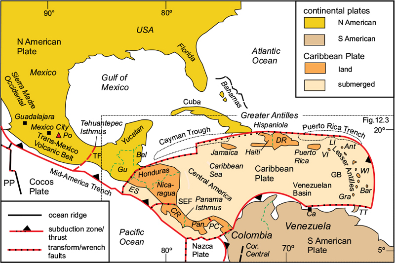
There are two main elements of the late Mesozoic to Present-day orogenic system in the Central America–Caribbean region: the Central American orogenic belt, and the island chains of the Caribbean, which are divided into the Greater and Lesser Antilles (Fig. 12.1). The Central American belt joins southern North America to northern South America through the Panama Isthmus. The greater part of Mexico, including the Sierra Madre Occidental Volcanic Province, is part of the North American Cordillera and was described in the previous chapter. At the southern end of the Sierra Madre Occidental is the active Trans-Mexican Volcanic belt, which ends at the narrow Tehuantepec Isthmus. East of the isthmus is what is called here the ‘Central American sector’ of the belt, divided into four tectonic blocks: the Maya, Chortis, Chortuga and Choco Blocks, discussed below. The latter two blocks make up the Panama Isthmus, which is curved into a remarkable S-shaped bend, centred on the Panama Canal. The eastern end of the Choco Block is joined to the Colombian coast.

Figure 12.1 Central America and the Caribbean. Simplified map showing the main geographic features. Ant, Antigua; Bar, Barbados; Bel, Belize; Ca, Caracas; CR, Costa Rica; DR, Dominican Republic; ES, El Salvador; Gra, Grenada; Gu, Guatemala; LI, Leeward Islands; Pan, Panama; PC, Panama Canal; Po, Popocatepetl Volcano; TT, Trinidad & Tobago; WI, Windward Islands. Tectonic features: GB, Grenada Basin; PP, Pacific Plate; SEF, Santa Elena Fault; TF, Tepuantepec Fault. After James, 2013.
The Trans-Mexico Volcanic Belt
This volcanic belt, running through southern Mexico, lies at the southernmost end of the North American Cordillera, immediately south of the Sierra Madre Occidental. It is an active (Neogene–Recent) volcanic arc 1000km in length and 160,000km2 in area, at its widest occupying the whole ‘waist’ of southern Mexico from the Pacific coast to the Gulf of Mexico. This area contains many active volcanoes over 4000m in height, including the famous Popocatepetl (Fig. 12.2), just south of Mexico City. The highest peak in the range is Pico de Orizaba (5636m) just east of Popocatepetl.
The Trans-Mexico Volcanic Belt results from the subduction of the Cocos Plate beneath the northern part of the Mid-America Trench, which follows the southern coast from just west of Guadalajara to the Tehuantepec Isthmus in Mexico. Interestingly, the arc containing the active volcanoes is oriented E–W – oblique to the trend of the trench. There is a short break in the arc at its intersection with the Tehuantepec Fault, after which it is replaced by the Central American Volcanic Arc.
The Central American sector
The circum–Pacific orogenic belt continues from southern Mexico through Guatemala, Honduras and Nicaragua, then follows the narrow, twisting Panama Isthmus to reach the northwestern coast of Colombia, where it joins the Cordillera Central at the northern end of the Andes. Although in politico-geographic terms ‘Central America’ excludes the country of Mexico, it is convenient to include the southernmost part of Mexico, known as the Maya Block, with the remainder of the Central American belt, which comprises the southwestern boundary of the Caribbean Plate, and is divided into three sections, the Chortis, Chortega and Choco Blocks (Fig. 12.1). The four blocks are separated by major fault zones.
The Maya Block
East of the Trans-Mexican Volcanic Belt, at the Tehuantepec Isthmus, there is a break in the mountain belt, which is displaced sinistrally along the N–S Tehuantepec strike-slip fault, to continue through Guatemala. The section of the belt from the isthmus up to the Honduras border is known as the Maya Block, and consists of a crystalline Precambrian and Palaeozoic basement overlain by Mesozoic sedimentary and volcanic strata deformed and metamorphosed in the Laramide Orogeny. This sector is similar to the accretionary complexes further north along the western margin of the North American Plate, and discussed in the previous chapter (see Fig. 11.7). There is no indication of a fundamental break between the Maya Block and the rest of Mexico. The foreland here is mostly concealed beneath the Gulf of Mexico, but the thick undeformed Mesozoic platform cover on the Yucatán Peninsula overlies continental-type crust.
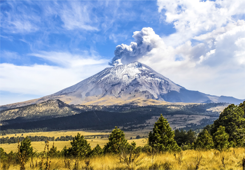
Figure 12.2 Popocatepetl. Active volcano in the Trans-Mexico Volcanic Belt near Mexico City. Shutterstock©Kuryanovich, Tatsiana.
The Chortis Block
Between Guatemala and Honduras, the belt is offset again by the major Motagua Transform Fault Zone, which marks the northwestern boundary of the Caribbean Plate (Fig. 12.3). The portion of the belt between here and Costa Rica is known as the Chortis Block. It has been estimated that considerable sinistral strike-slip displacement has taken place along this fault zone. The Chortis Block is composed of a Mesozoic–Cenozoic sequence, similar to that of the Maya Block, underlain by a late Precambrian–Palaeozoic basement, and although its geology cannot be directly correlated with the Maya Block succession, it is considered that the two blocks are separated only by the strike-slip fault displacement rather than by a major suture.
The Chorotega Block
This block, consisting of Costa Rica and western Panama, is separated from the Chortis Block by the E–W Santa Elena Fault Zone along the Nicaragua–Costa Rica boundary, and from the neighbouring Choco Block by the Panama Canal Fault Zone. Both this block and the neighbouring Choco Block consist of an assemblage of oceanic and volcanic-arc material emplaced during the Eocene on a basement of Cretaceous volcanics. The nature of the pre-Cretaceous basement is unknown but the crustal thickness of over 40km on Costa Rica is indicative of continental-type crust.

Figure 12.3 The Caribbean Plate. Enlarged central part of Figure 12.1 showing the main tectonic features. Symbols as in Figure 12.1, plus: AR, Aves Ridge; BR, Barbados Ridge; EPGF, Enriquillo–Plantain Garden Fault; MFZ, Motagua Fault Zone; PCF, Panama Canal Fault Zone. Geographic names: GC, Guatemala City; Ma, Martinique; Man, Managua; PP, Port au Prince; SJ, San José; SS, San Salvador; Te, Tegucigalpa; VI, Virgin Islands; VT, Volcán Tajumulco. Volcanoes: red triangles (only a few shown to indicate the extent of the volcanic belt). After James, 2013.
The Choco Block
East of the Panama Canal Fault Zone, the orogenic belt describes an S-shaped bend before it attaches to mainland South America. This section of the Panama Isthmus is known as the Choco Block and consists of similar material to the Chorotega Block, although the structures are oriented differently. It is considered that the Chorotega–Choco sector has been transported northwards relative to both Chortis and South America by a combination of bending and NW–SE strike-slip faulting in response to the convergence between North and South America during the Miocene (see Fig. 4.4D).
There is no evidence that the North and South American continents were separated by oceanic crust anywhere along the isthmus now connecting the two, and it is thought that the original connecting crust was merely stretched, then subsequently bent, rather than broken.
The Central American Volcanic Arc
This active volcanic arc extends for a distance of about 1500km from Guatemala to northern Panama, and includes several hundred volcanoes, many of which are currently active (Fig. 12.3). The tallest is the dormant Volcán Tajumulco in Guatemala which, at 4220m, is the highest peak in Central America. The arc parallels the south coast of Central America and results from the subduction of the Cocos oceanic plate along the Mid-America Trench.
The most recent volcanic phase commenced in the mid-Miocene with the separation of the Cocos Plate from the old Farallon Plate. The western end of the arc occurs at the on-land break between the Trans-Mexican and Central American arcs, and corresponds to its intersection with the Tehuantepec Fault at the western end of the Maya Block. The Cocos Plate is currently subducting northeastwards beneath Central America at a rate varying from 50 to 80mm/a.
The Caribbean
The Caribbean region includes the two outer arcs of the Greater and Lesser Antilles, together with the Caribbean Sea enclosed between them and the mainland of Central and South America (see Fig. 12.1).
The Greater Antilles Arc
This island arc embraces the larger Caribbean islands of Cuba and Hispaniola (Haiti plus the Dominican Republic) and extends east to Puerto Rico and the Virgin Islands, a total distance of about 2500km. The arc is not now volcanically active, but was formed during the Jurassic and Cretaceous as a result of the northward subduction of the oceanic Caribbean Plate. Both Cuba and Hispaniola consist of basaltic and volcanic arc rocks thrust over Mesozoic platform deposits. These lie in turn on a late Precambrian-early Palaeozoic continental basement similar to that of Florida, and represent the southern extended part of the North American continent. The eastern part of the arc, from Hispaniola to the Virgin Islands, lies along the northern transform fault boundary of the active Caribbean Plate. This part of the arc was volcanically active into the Palaeogene, but activity ceased in the mid–Eocene.
The Caribbean Plate
The currently active Caribbean Plate (Fig. 12.3) is bounded on its northwestern side by the Motagua–Swan transform fault, which follows a gently curved path from the Motagua Fault Zone at the Guatemala–Honduras boundary through the Cayman Trough, passing between Cuba and Haiti, and along the northern coast of the Dominican Republic to join the western end of the Puerto Rico Trench. From there it continues eastwards until the trench bends south-eastwards, east of the Virgin Islands, where the plate boundary becomes the Lesser Antilles Subduction Zone.
The Lesser Antilles Arc meets the South American mainland near the island of Trinidad, where it joins a transform fault that runs parallel to the northern coast of Venezuela to just west of Caracas, where it joins an arcuate thrust that in turn connects with the eastern end of the Panama Isthmus.
The Caribbean Plate is currently expanding towards the Atlantic, assisted by the eastwardly-extending transform faults that form its north and south boundaries. The disastrous 2010 Haiti earthquake was caused by sinistral strike-slip movement on the Enriquillo–Plantain Garden Fault, which is a branch of the main transform fault extending E–W along the south side of Hispaniola.
The Lesser Antilles Arc
This arc comprises the island chains of the Leeward and Windward Islands (northern and southern sectors of the Lesser Antilles, respectively) bordered on their outer side by the Puerto Rico Trench, and ending at Grenada near the Venezuelan coast. The currently active volcanic inner arc extends southwards from the small island of Saba, west of Antigua in the Leeward Islands, forming a wide arc facing eastwards towards the Atlantic Ocean. The trench is up to 9200km deep at its western end but becomes shallower eastwards and southwards, until by Barbados it has become completely filled by sediment and is replaced by an accretionary prism forming the outer fore-arc ridge (Fig. 12.4). Between the volcanic arc and the trench is an inactive outer arc consisting of several islands, including Antigua in the north and Barbados in the south, joined by a submerged ridge. There are 17 active volcanoes in the inner arc, including Mt. Pelée on Martinique (Fig. 12.5). Mt. Pelée is famous for its 1902 explosive eruption, which left about 30,000 dead, and gave rise to the concept of the ‘Peléan’ type of vulcanicity characterised by hot, glowing clouds of volcanic ash and catastrophic pyroclastic flows.

Figure 12.4 The Lesser Antilles Arc. Crustal section based on seismic data across the Barbados Ridge. Note that the deformation front has migrated eastwards some distance from the site of the original trench. After Westbrook, 1982.

Figure 12.5 Mt Pelée, Martinique – site of the disastrous 1902 explosive eruption that gave rise to the ‘Peléan-type’ of vulcanicity. Shutterstock©Albert Barr.
Tectonic History of the Central America–Caribbean region
The origins of the strange geometry of the Caribbean region can be traced back to the break-up of the Pangaea Supercontinent in the Jurassic, and are briefly summarised in Chapter 4 (see Fig. 4.4). Figure 4.4A shows that in the Triassic, South America was joined to North America but, as a result of the opening of the Central Atlantic during the Jurassic and early Cretaceous, North America rotated clockwise away from Africa, which was still joined to South America. This movement resulted in NW–SE extension between the Gulf Coast of the USA and northern South America, on the one hand, and a substantial sinistral strike-slip displacement on the other, as shown in Figure 4.4B. The amount of displacement should be roughly equivalent to the 1600km of Jurassic–early Cretaceous ocean crust formed off the North American coast up to the point when the Mid-Atlantic Ridge spread into the South Atlantic. Part of this displacement was taken up by sinistral movement along the Motagua–Swan Transform Fault, which might account for about half, and the remainder by the NW–SE extension of the region between the North and South American Plates.
The effect of the NW–SE extension was to cause thinning of the continental crust of the Gulf of Mexico and the Caribbean Sea, forming ocean basins in the centre of the Gulf of Mexico and east of the Yucatán Peninsula. The area between Central America and the Greater Antilles was also extended due to the retreat of the Lesser Antilles Arc into the Atlantic, and subsided to form the Caribbean Sea. The extension was uneven across this region, leaving elevated submarine areas such as the Nicaragua Rise.
A compressive phase occurred in the later Cretaceous and early Palaeogene due to a combination of westwards push from the Mid-Atlantic Ridge and an increasing convergence rate at the subduction zone along the Pacific margin. This gave rise to the widespread obduction of oceanic material, including major ophiolite bodies, in Central America and the Greater Antilles Arc.
From the late Eocene until the Present, the Caribbean Plate expanded and grew eastwards due to the retreat of the Lesser Antilles Subduction Zone as the Atlantic crust subducted beneath it. An additional 300km was added to the Caribbean Plate as a result.
In the Miocene, northwards convergence of South America with Central and North America resulted in bending and north-eastwards displacement of the Panama Isthmus and northernmost South America.
The Andes
The Andes mountain belt follows the western boundary of the South American continent for 7600km from northern Colombia to Tierra del Fuego in southern Chile, spanning 65° of latitude from 10°N to 55°S (Figs. 12.6, 12.7). For most of this distance, the belt is a rather narrow mountain spine only about 200km wide, but it broadens to over 700km width in the central section through Bolivia. Only the northernmost part deviates from this simple pattern, dividing into three branches as it passes through Colombia. The Andes are the longest, and apart from the Himalayas, the highest on-land mountain belt on Earth. They traverse seven countries, from north to south: Venezuela, Colombia, Ecuador, Peru, Bolivia, Chile and Argentina; for most of their length they divide the narrow coastal belt from the remainder of the continent, and there are few routes across.
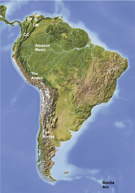
Figure 12.6 The Andes and the Columbian chains. CC, Cordillera Central; CM, Cordillera Mérida; SP, Sierra de Perija. Shutterstock©Arid Ocean.
The orogenic belt can be divided into three sectors: northern, extending from the north coast of Colombia and Venezuela to southern Ecuador, which trends NNE–SSW to N–S; central, trending NW–SE through Peru and Bolivia; and southern, trending N–S, through Chile and Argentina, but bending round almost to E–W in Tierra del Fuego. The junction between the central and southern sectors in Bolivia, which involves a change in orientation of 35°, is known as the Arica Embayment or ‘Arica elbow’. This area corresponds to the broadest part of the belt, containing the elevated plateau of the Altiplano, much of which is over 4000m in height and contains several of the highest peaks in the Andes.
Plate-tectonic summary
In plate-tectonic terms, the Andean belt presents a relatively simple scenario: an active plate boundary is defined by a subduction zone along which the Nazca and Antarctic oceanic plates are descending eastwards beneath the South American continent along the Peru-Chile Trench, and an active volcanic arc follows the mountain belt for most of its length. It has long been regarded as the type example of an active continental margin – the ‘Andean margin’, where the deformation and uplift of the orogenic belt are due to the subduction process alone, and continent-continent collision has played no part.
The volcanic arc is not continuous throughout; there is a gap between the Ecuador–Peru border and the point where the Nazca Ridge meets the Peruvian coast about 150km southeast of Lima. This sector is known as the Peruvian ‘flat-slab’ segment, attributed to a subduction angle too shallow to intersect the zone of magma generation and a relatively fast convergence rate of 709–0mm/a. The distribution of seismicity indicates a shallow Benioff Zone here, whereas to the north and south, it indicates slab dips of over 30°. A second flat-slab sector is present in the Chilean sector from south of Antofagasta to where the Juan Fernandez Ridge intersects the coast at 33°S, near Valparaiso. South of the Chile triple junction, where the Chile Rise meets the subduction zone, the Antarctic Plate is subducting much more slowly, about 20mm/a beneath Patagonia.
From the late Cambrian Period, through the remainder of the Palaeozoic, and during the early Mesozoic, the western border of what is now South America was an active continental margin, where oceanic crust of the ancestral Pacific was being consumed. The tectonic history of the present orogenic belt began with extensional rifting in the Triassic, as the long process of break-up of Pangaea commenced. During the Jurassic, volcanic arcs developed offshore, with back-arc basins on their landward side. With the opening of the South Atlantic Ocean during the Cretaceous, changes in the subduction regime along the Pacific margin prompted the commencement of compression and uplift along what became the Andes belt. Subduction continued with its attendant vulcanicity through the Cenozoic as the orogenic belt grew, and several large foreland basins, such as the Orinoco and Amazon Basins, developed on the South American craton to the east. The present structure had taken shape by the mid-Miocene.
The Northern Sector – Venezuela to Ecuador
This sector includes the part of the Andes belt that passes through Ecuador and Colombia, ending at the northern coast of Venezuela (Figs. 12.7, 12.8A). The mountain belt divides after it crosses the Colombian border, one branch, the Cordillera Central, proceeding in a NNE direction and dying out west of Bucaramanga to be replaced by a wide coastal plain. This part of the belt includes many peaks over 5000m in height and numerous active volcanoes. The second branch, known as the Cordillera Oriental, equally high but lacking active vulcanicity, strikes north-eastwards and crosses the Venezuelan border to reach the coast west of Caracas. The Venezuelan sector of this chain is named the Cordillera Mérida. At the City of Bucaramanga, another mountain chain, the Sierra de Perijá, branches off and takes a sinuous course northwards towards the coast. The Central and Eastern Cordillera are separated by a broad valley containing the capital city of Bogotá.
In tectonic terms, the northern sector can be divided into a western accretionary zone consisting mainly of oceanic rocks, a narrow central zone dominated by Cenozoic volcanic rocks that overlie the Precambrian basement, together with numerous plutonic intrusions, and an eastern zone corresponding to the foreland fold-thrust belt (Fig. 12.8A). The western accretionary complex is separated for much of its length from the central zone by a major dextral strike-slip fault complex – the Dolores–Guayaquil Megashear. Much of the Western Zone is below sea-level, but the on-land part includes several terranes consisting of thrust packages of oceanic material.
In the central zone, the Precambrian basement with its plutonic intrusions has been uplifted to form the high mountains of the Cordillera Central. The eastern zone contains a thick sequence of Palaeozoic to Cenozoic rocks deposited on the Precambrian basement of the South American Plate. This zone broadens out northwards to over 600km near Bucaramanga, at which point the Cordillera Oriental divides into the Sierra de Perijá and the Sierra de Mérida. The elevated parts of the eastern zone, including the Cordillera Oriental and its northern branches, correspond to the uplifted sectors of the fold-thrust belt and are separated in the north by wide unfolded regions. These belts have all experienced dextral transpressional movements as a result of the oblique (E–W) convergence direction of the Nazca Plate. The Venezuelan part of the fold-thrust belt is a response to the Miocene convergence between South and North America.
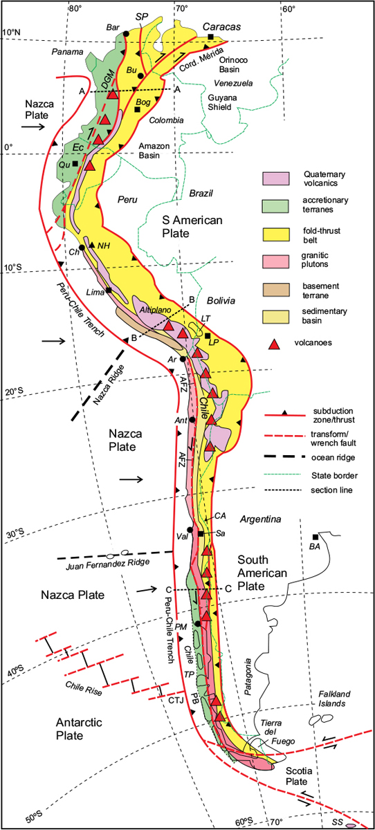
Figure 12.7 The Andes. AFZ, Atacama Fault Zone; Ant, Antofagasta; Ar, Arica; BA, Buenos Aires; Bar, Baranquilla; Bog, Bogota; Bu, Bucaramanga; CA, Cerro Aconcagua; Ch, Chimbote; CTJ, Chile Triple Junction; DGM, Dolores-Garcia Mega-shear; Ec, Ecuador; LP, La Paz; LT, Lake Titicaca; NH, Navado Huascarán; PB, Patagonian Batholith; PM, Porto Montt; Sa, Santiago; SP, Sierra de Perija; SS, South Shetland Islands; TP, Taitao Peninsula; Val, Valparaiso. Note that volcano symbols indicate groups of individual volcanoes. After Moores & Twiss, 1995.
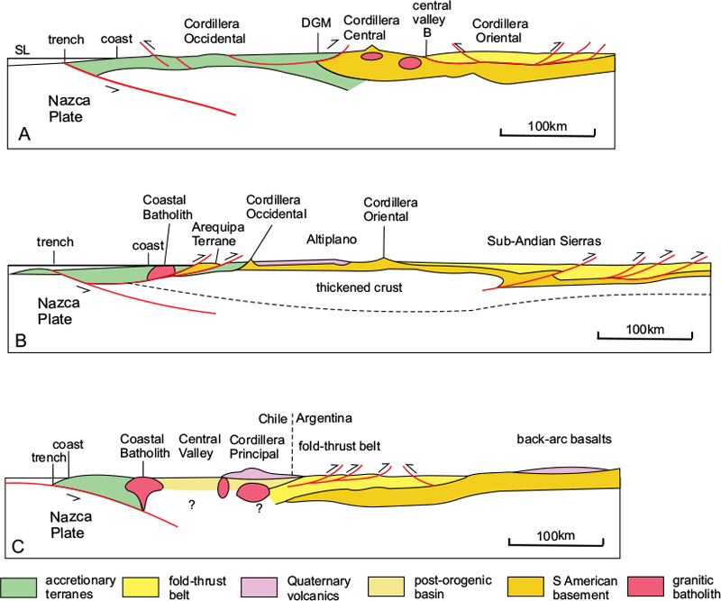
Figure 12.8 Schematic sections across the Andes. A. Northern sector: Colombia to Venezuela, taken along E–W line A–A* through Bogota. B, Central sector: SW–NE line B–B through Peru, from just north of Arica. C, Southern sector: E–W line C–C from south of Valparaiso. B, Bogota; DGM, Dolores-Garcia megashear. Note that section B represents the Peruvian ‘flat-slab’ segment and lacks contemporary vulcanicity. [*See lines of section on Figure 12.7.] After Moores & Twiss, 1995.
East of the fold-thrust belt is the South American foreland, here represented by the Guyana Shield, which is unaffected by Andean deformation.
The Central Sector – Peru and Bolivia
As the Andes pass from southern Ecuador into northern Peru, both the mountain belt and the coast bend abruptly through 60° to trend NW–SE, oblique to the E–W convergence direction of the Nazca Plate, but in the opposite sense to that of the northern sector, which accounts for the presence of sinistral transpressive structures in the coastal zone. The volcanic arc of the northern sector ends near the Ecuador border and only reappears 500km to the south, near the Bolivian border. This volcano-free sector is the ‘Peruvian flat-slab segment’ referred to above, and is attributed to the faster convergence rate of the Nazca Plate. Here the western accretionary zone is very narrow and almost entirely submerged (Fig.12.8B). The belt of coastal mountains, the Cordillera Occidental, is composed largely of a compound batholith of late Jurassic to Cretaceous age that has been intruded into Precambrian basement of the Arequipa Terrane. This allochthonous terrane is thought to have originally formed part of the South American foreland, but was thrust eastwards over the Mesozoic cover of the central zone during the Andean Orogeny.
The remainder of the Peruvian sector belongs to the very broad foreland fold-thrust belt, which is composed of a Mesozoic to Cenozoic sedimentary cover overlying the Precambrian basement of the foreland and deformed in the Andean Orogeny. Near the coastal batholith, the cover consists of oceanic-type rocks but grades inland into strata representative of the continental slope and platform. The sedimentary cover is overlain by Quaternary volcanics; these form a narrow belt in the north but broaden out near the Bolivian border.
The western part of the fold-thrust belt has been elevated to form the Cordillera Occidental and was deformed during the Eocene, whereas the central part is relatively flat-lying and forms the high plateau of the Peruvian Altiplano. East of the plateau, in the Cordillera Oriental, the basement has been uplifted during a later phase of the Andean Orogeny and affected by steep reverse faults and open folds. The Sub-Andean Zone, east of the Cordillera Oriental, is characterised by imbricate NE-directed thrusting of Neogene age.
Both the western and eastern Cordillera contain peaks up to over 6000m high, and the Altiplano Plateau itself is around 4000m high. The highest peak in Peru, at 6768m, is Nevado Huascarán (Fig. 12.9) in the Cordillera Occidental, east of Chimbote. Somewhat confusingly, there are three parallel ranges in the north: western, central and eastern cordillera, separated only by narrow valleys, whereas in the south the central plateau separating the western and eastern ranges is 200km across, and is occupied by the famous Lake Titicaca. This high plateau broadens further to about 400km wide in northern Bolivia, where it is known as the Bolivian Altiplano. This sector corresponds to the ‘flat-slab’ segment of the subduction zone and mostly lacks vulcanicity. Here the crust is up to 70km thick, the whole region is elevated to above 4000m, and the central valley has disappeared.
The amount of shortening across the Peruvian fold-thrust belt has been estimated at 120–150km – around 25%. This figure is consistent with the amount of westward movement of South America (relative to a fixed trench position) during the Neogene.
The Southern Sector – Chile and Argentina
The junction between the Central and Southern sectors of the Andean belt is marked by another abrupt change in orientation of both the coastline and the mountain range from NW–SE to N–S, and occurs at the Arica embayment near the Peru–Chile border (Fig. 12.7). The Chilean Andes are over 4000km long and span about 37° of latitude. The range is relatively narrow, for the most part under 200km in width, but it broadens in Northwest Argentina and Bolivia to about 550km. In the north, there is a very steep rise in elevation from the coastal plain, here occupied by the Atacama Desert, to over 6000m. In much of the southern sector (Fig. 12.7), the coastal plain is almost non-existent, but there are numerous islands forming a chain parallel to the coast. The highest peak in the southern sector is Cerro Aconcagua (6962m) 150km east of Valparaiso, and just across the border with Argentina.
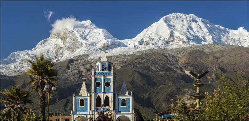
Figure 12.9 Nevado Huascarán, 6768m. Extinct volcano and highest peak in the Peruvian Andes. Shutterstock©Christian Vinces.
As in the Peruvian sector, the belt is accompanied offshore by the Peru–Chile Trench, which attains its greatest depth of over 8000m just south of the Arica embayment. From its intersection with the Juan Fernandez Ridge southwards, the trench is filled with sediment, and consequently not obvious as a topographic feature. South of the Chile Triple Junction, where the trench meets the Chile Rise, it is replaced by a transform fault. From here southwards, the Andes are flanked by the Antarctic Plate.
There are again three main tectonic zones: western, central and eastern. The western zone contains the Coastal Cordillera, which consists mostly of late Palaeozoic to Mesozoic igneous and metamorphic rocks, including the large Patagonian Coastal Batholith of Permian age. South of Puerto Montt, this zone consists of the many islands and archipelagos that fringe the west coast. Much of this southern sector consists of a deformed and metamorphosed accretionary prism of Mesozoic age. The eastern margin of the western zone is defined over much of its length by the Atacama Fault Zone, which runs parallel to the coast for over 1000km from the Peruvian border to near Valparaiso. Another fault zone forms the boundary between the coastal zone and the Patagonian Batholith in the southern part of the sector. These fault zones exhibit sinistral transpressional characteristics and are believed to date back to the Mesozoic. The more recent structures are a response to E–W compression, reflecting the present E–W convergence direction.
The central zone consists of a low-lying area formed by a Mesozoic to Cenozoic sedimentary basin; between Santiago and Puerto Montt, this region provides most of Chile’s agricultural land and hosts several of its cities. South of Puerto Montt, the central zone is absent.
The eastern zone contains the main Andean mountain range, the Cordillera Principal, and corresponds to the fold-thrust belt, which was uplifted during the Miocene, and is still actively rising. The height of the mountain range decreases southwards towards Tierra del Fuego from over 6000m in Northern Chile to under 4000m in Patagonia.
Volcanoes form an almost continuous line 200–400km from the coast, from the Peru–Chile border to the Chile Rise, generally along the Chile–Argentina border. There is one gap, between 27°S and 31°S, attributed to the second flat-slab section of the subduction zone referred to earlier.
Near the southern end of the belt, the Peru–Chile Trench is intersected by the Chile Rise, which separates the Nazca and Antarctic Plates. This ridge currently lies offshore from the Taitao Peninsula but has been slowly migrating northwards at a rate of about 20mm/a as the Antarctic Plate expands. South of the Chile Rise, the offshore plate boundary, now separating the South American from the Antarctic plates, becomes a transform fault. The southernmost sector of the belt, through southern Patagonia and Tierra del Fuego, bends round into an NW–SE orientation. Here it is influenced by a zone of sinistral strike-slip faults that define the northern boundary of the Scotia Plate.
Antarctica and the Scotia Arc
The former continuation of the Andes belt into the Antarctic Peninsula was broken during the middle Jurassic when Gondwana split up and East Gondwana (Antarctica–Australia–India) moved away from South America–Africa. As South America began to move westwards relative to Antarctica in the mid-Cretaceous, the land bridge between the two continents became extended, then split into several fragments, including South Georgia and the South Orkney Islands. By the early Eocene, the increasing separation between South America and Antarctica had created the Scotia Sea, which was bounded on its north and south sides respectively by the North and South Scotia Ridges.
The Scotia Sea Plate
This small plate (Fig. 12.10) is defined on its northern and southern sides by transform fault zones along the North and South Scotia Ridges respectively, both of which are northwardly convex arcs. The western side is formed by the Shackleton Fracture Zone, which links with the end of the Peru–Chile Trench to the north. The eastern side of the plate is defined by the active volcanic Scotia Arc. The most easterly section of the Scotia Sea Plate is the most active part and forms a microplate, the South Sandwich Plate, separated from the main plate by a spreading ridge. This microplate was formed as a result of back-arc expansion from the South Sandwich Subduction Zone during the last eight million years.
Figure 12.10 The Scotia Plate. The active Scotia volcanic arc forms the eastern boundary of the Scotia Plate; the northern and southern boundaries are transform faults along the North and South Scotia Ridges respectively; the western boundary is also a transform fault that links with the Peru–Chile subduction Zone. El, Elephant Island; NEGR, NE Georgia Rise; SSR, South Sandwich Ridge; SST, South Scotia Trench. After joannenova. com.au., via Wikimedia Commons.
The Scotia Arc
There are eleven volcanoes on the small islands and seamounts in this 400km-long arc, most of which are currently active. On the Atlantic side of the arc is the South Sandwich Trench, along which Atlantic oceanic crust belonging to the South American Plate is subducting at the relatively fast rate of 70–90mm/a. At its southern end, the arc meets the transform fault along the South Scotia Ridge. From this arc–fault junction, the South American plate boundary strikes eastwards into the Atlantic to link up with the Mid-Atlantic Ridge.
Antarctica
Although much of the Antarctic continent is still largely unknown, it is clear that the whole of it now lies within the Antarctic Plate, whose northern boundary runs from the Chile Rise, along the Shackleton Fracture Zone to Elephant Island, and from there follows the South Scotia Transform Fault towards the American–Antarctic Ridge, as shown on Figure 12.10. Other ridges surround the continent on its eastern, southern and western sides. However, during the early Mesozoic, Western Antarctica was the active margin of this part of Gondwana, and a subduction zone with its accompanying volcanic arc extended from the southern end of the Andes along the Antarctic Peninsula and the West Antarctic Mountains (Fig. 12.11). East Antarctica, which comprises the larger part of the continent, consists of a late Precambrian craton with a younger platform cover. The craton is bounded on its western side by the Transantarctic Mountains, which represent the uplifted western margin. During the early Cenozoic, an extensional rift running from the Weddell Sea to the Ross Sea developed between West and East Antarctica, and is still tectonically active.
There are about 37 known volcanoes in Antarctica, at least five of which are currently active. These include Mount Melbourne and the famous Mount Erebus, which lie along the southern part of the Trans-Antarctic Mountains. Erebus, situated on Ross Island, was first climbed by members of Ernest Shackleton’s first polar exploration party in 1908. It is thought that the vulcanicity of this belt is related to the extensional rift, and it has been suggested that it may originate from a mantle plume rather than from a currently active plate boundary.
There are still two active volcanoes on the Antarctic Peninsula, opposite the South Shetland Islands, together with at least a further two that are extinct or dormant. These are related to a short stretch of the now inactive subduction zone that lay northwest of the South Shetland Islands. This subduction zone meets the Shackleton Fracture Zone and the South Scotia Transform Fault at a triple junction near the tiny Elephant Island, at the northeast end of the South Sandwich Island chain (see Fig. 12.10).
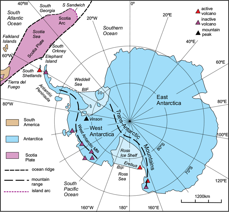
Figure 12.11 Antarctica. The Antarctic Peninsula and the West Antarctic Mountains represent a Mesozoic volcanic arc that was added to the Palaeozoic East Antarctic Craton. The Trans-Antarctic Mountains are the uplifted margin of the old craton. The region between the two mountain ranges, extending from the Weddell Sea to the Ross Sea, is an extensional rift. The Vinson Massif, at 4897m, is the highest peak. Only a representative selection of the extinct volcanoes is shown. BIF, Barrier ice front. After Bulkeley, 2008.
It was on Elephant Island that Sir Ernest Shackleton and his 1914 expedition spent the winter of 1915 after their ship was crushed by the sea ice. The subsequent 1300km journey across the Scotia Sea undertaken by Shackleton and 5 companions in an open boat to South Georgia is one of the most remarkable exploits in the history of polar exploration.