 THE FRONTAL DEPRESSION
32 WEATHER
The two most important variables in yachting are the tides and the weather. Tides we can predict, years ahead if need be; weather is different. With the exception of the trade wind belts of tropical and subtropical latitudes, we are down to comparatively short-term weather forecasts and informed personal observation when we need to know what the wind is going to do (and who doesn’t?).
For coastal and offshore sailing, we can find most of what we require in the numerous commercial and free public sources of meteorological information. These range from radio, TV, Navtex and weatherfax, through harbourmasters’ noticeboards and newspapers. The trouble is that forecasting has become so sophisticated that there is a growing temptation to rely upon it implicitly and ignore the old ways. The sky, the sea state and the manner in which the cows are sitting in a riverside field are still useful sources of data to those with the knowledge to use them, and sometimes the official weather predictions are out of reach when more primitive signs are plainly manifest.
The true answer to enjoying the weather and not being caught napping by it is to make informed use of forecasts where they are available, and to temper the information or, if need be, substitute it with what your senses are telling you. However, you can do neither if you do not understand the basis of air movements. For our purposes at least, this is not a complicated subject, and the essence of what the temperate waters’ Yachtmaster needs to know is set out below. The explanation revolves around the anatomy of the most common wind-inducing weather system of middle and high latitudes: the depression.
If Erik the Red could take a stroll down a modern marina pontoon on a stormy day, there would be little that he could recognise except the rain. Bad weather is the same now as it was in the good old days and it stems from exactly the same causes. Nowadays we can predict it, draw computer models of it and build ships so huge that they are not unduly bothered by it, but so far we haven’t made it go away.
THE FRONTAL DEPRESSION
A depression is a free-moving cell of air whose central pressure is lower than that of the surrounding atmosphere. A system can vary in magnitude between a young ‘low’ only a hundred or so miles across and a mature system stalled on the eastern side of an ocean, affecting conditions 1,000 miles from its centre. Depressions are a primary cause of high winds and of all forms of precipitation, including fog. They can produce storms of hurricane violence, or pass by virtually unnoticed. They are equally common both north and south of the Equator, but for convenience we will consider the northern version first.
MUTUALLY EXCLUSIVE AIR MASSES
The machinery of a depression depends entirely upon the fact that air masses originating in different climatic circumstances are unwilling to mix. Wherever you are situated, your local air arrives in enormous packages, the nature of which is governed by where they have come from and what has been happening to them on the way.
A parcel of warm air, for example, is capable of holding more water vapour than an equivalent quantity of comparatively cold air. If a mass of air moves northwards up the Atlantic from the tropics it will therefore be rich in moisture by the time it reaches the temperate zones. This type of air is referred to as tropical maritime.
Air originating in polar and subpolar zones is obviously much colder, and hence is inclined to be drier and denser. In the North Atlantic the enormous mass of Greenland’s two-mile-thick ice cap together with the Canadian Arctic supplies a powerful source of so-called polar maritime air. ‘Polar’ for obvious reasons; ‘maritime’ because it has come across enough water to take the edge off its dryness.

 The cold front has passed after the gale-swept warm sector of a deep depression. Things are looking up as the wind veers.
The convergence line of these two global air masses is known as the polar front. It is nowhere near the actual Pole, but meanders seasonally between the 35th and the 60th parallels (north and south). Occasionally, it can be found even outside these rough limits.
AIR CIRCULATION
A person standing at the Equator is actually moving very quickly relative to the space above him, with the turning of the Earth. An explorer stationed at the Pole isn’t moving in any direction at all. Instead, he is pirouetting like a skater in a slow spin, executing one revolution every 24 hours. If the sun-lover careering round at the Equator could hurl a ball far enough to get any where near the polar explorer, it would not arrive because it would carry with it a component of its original lateral movement and would curve off to one side long before it reached the Pole. Similarly, if the deep-freeze merchant threw a ball from the Pole towards his chum on the Equator, by the time it reached the 0° parallel, its target would have been carried smartly eastwards, leaving the ball to fall into the ocean at a point way to the west of where he was standing when it was thrown. If you could trace its route on the Earth’s surface it would appear to curve away westwards as it left the higher latitudes.
The same is true of any free-moving item in the atmosphere with a north–south component in its direction of travel, including an air mass. In the northern hemisphere this tendency causes air to circulate clockwise around a high-pressure area and anticlockwise around a centre of low pressure, rather than flow directly from ‘high’ to ‘low’ as would otherwise be the case.
DEPRESSION FORMATION
At the polar front in the northern hemisphere, the high-pressure centre of the cold polar air lies to the northwards, so as air tries to flow southwards towards the low-pressure centre it is displaced to the westwards along the front, setting up the clockwise circulation of the system.
Down in the Horse Latitudes (somewhere in the 30s), the other side of the low-pressure zone, lies the mid-oceanic ‘high’. This is typified by the ‘Azores high’ in the North Atlantic, which is funnelling tropical maritime air up its western leg towards the polar front. By the time this air has reached the front, it is moving to the eastwards and is still part of the main clockwise circulation of the oceanic system (Fig 32.1).
Where the two air masses are actually colliding, the warm air will tend to rise as the dense, cold air tries to slide underneath it like a wedge. As this happens, the moisture in the tropical maritime air condenses in the form of clouds, and rain.
The situation is inherently unstable. Two independent air masses trying to overlap one another while they travel in opposite directions doesn’t encourage peace on earth. It takes little disturbance to produce an eddy in the airflow at the front. Such a ‘kink’ on the front may result from a local area of extra warming, which causes the warmer air to rise slightly faster and the cold air to try to push in behind. It can also result from the presence of a mountain (Pico in the Azores creates amazing eddies in the air) or just a particularly heavy inrush of one type of air into the space of the other.
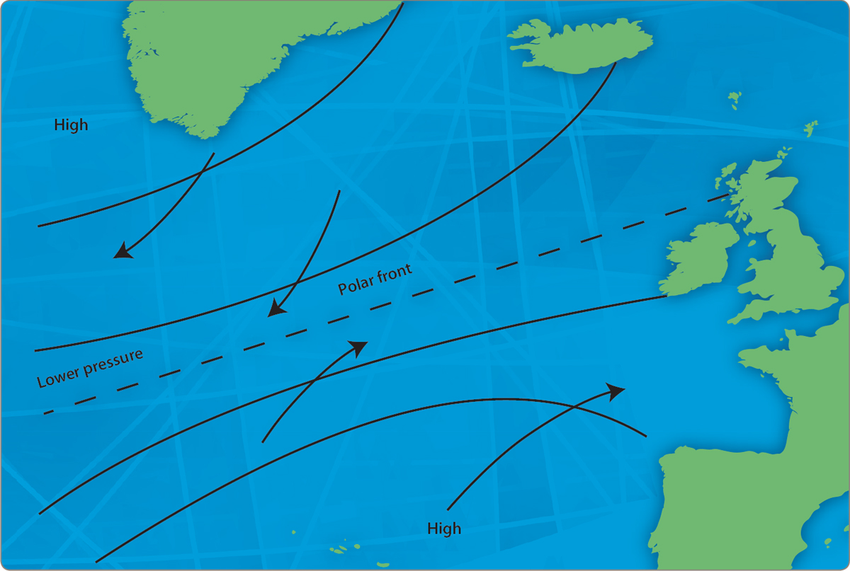
Fig 32.1 Oceanic air circulation: eastern N Atlantic.
Once a wave has formed on the front, things take on a life of their own. Fig 32.2 shows how a package of warm, moist air moves up into a ‘salient’ in the cold air to the north of it. As it does so, cold air moves down behind it from the north and tries to undercut it. The warm air is rising, causing precipitation that releases what is known as latent heat. This extra heat helps to energise the system and set up the cyclonic circulation.
Within 24 hours the eddy will have developed into a young depression showing a warm front (a front with warm air behind it, overlapping the cold air it is displacing), a cold front (followed by colder air which undercuts the warm air) and a complete anti clockwise air circulation. It will then set off on its life’s journey.
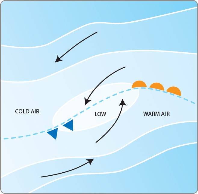
Fig 32.2 Depression formation.
DEPRESSION TRACKS
The movements of individual depressions do not conform to a tight stereo type. However, by studying averages over a period of years it is possible to draw some general conclusions. In its first day or two of life, the vertical development of a depression is comparatively modest and is unlikely to penetrate the jet stream wind systems of the upper atmosphere. Because it is not interfering with these, the young ‘low’ will tend to move along their general direction, which more often than not is north-easterly. As it matures, the system extends its influence higher and higher until it is distorting the upper winds. It will probably then slow down and may turn from its straight track usually, but not always, to the left. Ultimately, as we shall see, the circulatory mechanism stalls and decays.
FRONTAL ANATOMY
The boundaries of the warm sector of a depression are marked by a warm front on its leading edge and a cold front behind (Fig 32.3). As a warm front moves along, it pushes across the upper cold air first and gradually A comes down to sea level over a width of anything up to 200 miles.
The first visible evidence of a warm front arriving is the presence of high ‘mare’s tail’ clouds known as cirrus (Fig 32.4). These are followed by a layer of thin cirro stratus cloud, which often begins by generating a halo round the sun or moon but ends by obscuring the sky completely as the cloud base falls and thickens up. This is accompanied by a falling barometer and the wind will be backing (shifting counterclockwise), generally to the south or the south-east.
The breeze, which is now strong if the depression is built on a sharp pressure gradient, will veer (shift clockwise) as the front goes through. The barometer will probably stop falling. Rain is now intermittent and visibility remains moderate or poor with fog a possibility. The wind will typically be from the south-west.
You are now in the warm sector. How long you stay there will depend upon the size and rate of progress of the weather system, but 12 hours would not be uncommon. As the cold front approaches, the wind may back a little and pressure often drops. Rain will fall more heavily and conditions generally deteriorate.
The arrival of a fully paid-up cold front can be one of nature’s more dramatic atmospheric events. Because the cold air is heavier than that in the warm sector, it pushes along at sea level first, with its wedge of air rising to great heights astern of it. You don’t get a lot of warning, but you can’t miss it when it comes (Fig 32.5).
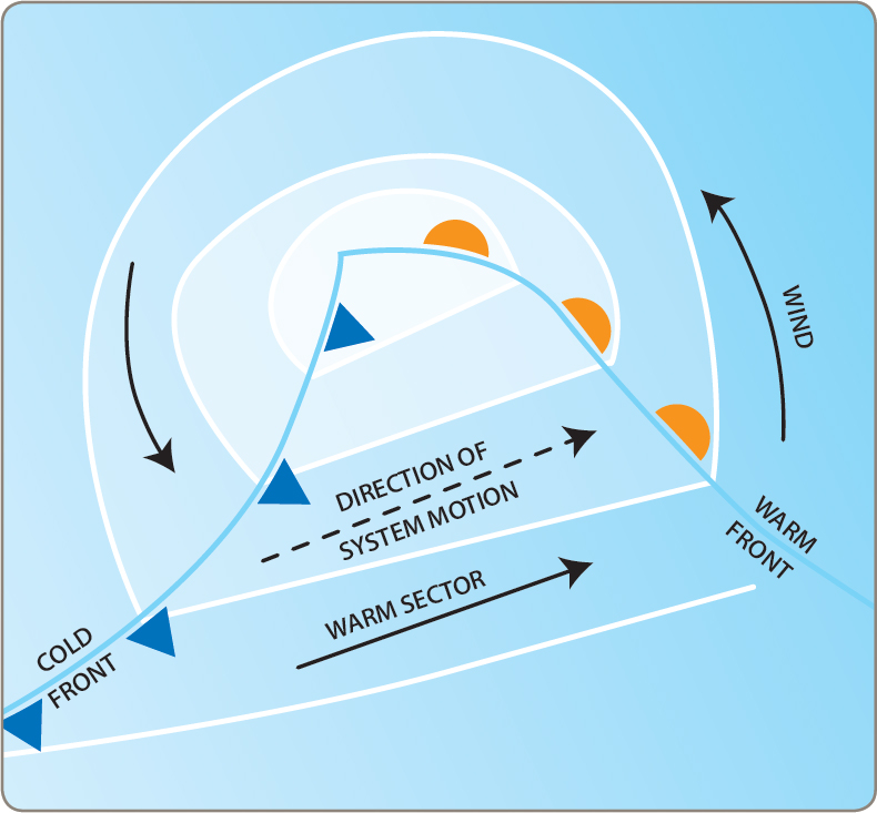
Fig 32.3 A frontal depression.

Fig 32.4 A warm front.
Classically, the wind veers sharply into the north-west with a ripper of a squall to accompany it. The barometer climbs rapidly and visibility suddenly opens up as the cold, clear air streams down from the Arctic. Huge cumulonimbus clouds tower up to 30,000 ft (9,144 m), sometimes with anvil-shaped tops flying off to leeward in the thin upper atmosphere. As the advancing cold air drives the moisture upwards, convection in the clouds may be so powerful that the raindrops are carried aloft until they freeze, to rattle back to earth as hail stones. Blue sky reappears as the front moves past, and the wind moderates gradually.

Fig 32.5 A cold front.
OCCLUSIONS
As the pair of fronts chase one another across the ocean, the depression is doomed from the outset because the cold front always moves faster than the warm. When the cold air behind the warm sector finally overtakes the cold air in front, its advancing wedge lifts the warm air off the sea, forming an occlusion. For a while this hangs around at a moderate altitude, producing varying degrees of unpleasantness, and although the writing is on the wall for the depression once this happens, the system may still remain active for quite some time as the occlusion spirals in around the centre. It is usually at this point in its life that a depression, if it is not to perish without issue, gives birth to one or more secondaries.
SECONDARY DEPRESSIONS
When a depression slows down, generally but not always on the eastern side of an ocean, it frequently trails its long cold front out behind it. The front, which is in effect once again a part of the polar front, is in a susceptible condition for the formation of a wave that will result in a new depression. These secondary depressions are often more violent than their parents. They can also develop with unforecast rapidity. For this reason it always pays to watch the western sky and the barometer carefully for a while when things seem to have cleared up. A belt of cirrus, a halo round the sun, a dip in the air pressure, and hold on to your hat! There’s more where the last one came from.
If a low-pressure system passes to the southward you may well avoid the frontal systems; the wind pattern will also be very different. Beginning in the south-east, the breeze will back to the east as the centre passes. It will then work round to north of east and may finally merge with the north-westerly airstream behind the cold front. Weather conditions on the north side of a depression are often less violent than in the frontal department down south, but there is still plenty of wind and rain about. In winter, the north-east winds can be particularly severe.
LOCATING A LOW-PRESSURE CENTRE
If you are sailing coastwise, the forecast will keep you aware of what weather systems are bound your way. In mid-ocean you’ll have to work things out for yourself, unless you have access to modern forecasting.
Fortunately, it’s hard to mistake an approaching ‘low’ as it marches up out of the west. To find the approximate location of its centre, stand with your back to the wind and extend your left hand (right hand in the southern hemisphere) at 90° to the way you are looking. ‘Buys Ballot’s Law’ states that you are then pointing to somewhere near the middle of the system. You can make a fair guess at which way it’s heading if you do this every couple of hours. Once you’ve sorted that out, all you need to do is decide how you are going to handle it.
WIND STRENGTHS IN DEPRESSIONS
The windspeed around a ‘low’ is dependent upon how tightly packed are the isobars that indicate its depth. If you are at sea, as soon as you fancy a depression is approaching, you should plot the barometer readings every hour, whatever your normal routine. If the barometer tumbles at a rate of two millibars per hour for at least three hours, stand by for gale-force winds. You may suffer these even if the barometer is less active, but two millibars per hour is a sure sign of grief.
CYCLONIC WINDS
Conditions for the luckless mariner caught in the centre of a depression are grim in the extreme. If the system is vigorous, the windspeed could well vary between zero and force 8 in as many minutes, and the blast can come from any direction. Precipitation is highly probable and the sea state will be a shambles, with steep seas hurling themselves around in total confusion, looking for the discipline of an honest wind.
DEPRESSIONS IN THE SOUTHERN HEMISPHERE
Depressions in the southern hemisphere behave exactly like their northern relatives, except that they are the other way up. The air moves clockwise around southern ‘lows’ but the winds in the warm sector are still westerly and the mechanism of the systems is exactly the same.
Land distorts depressions and can render their behaviour far less predictable than at sea. To appreciate their organisation to the full, you need to tackle them in mid-ocean. You don’t have to like them, few of us do, but there is a straightforward gutsy character about them that you might just find yourself missing if ever you slope off to the tropics for a year or two of trade-wind sailing.
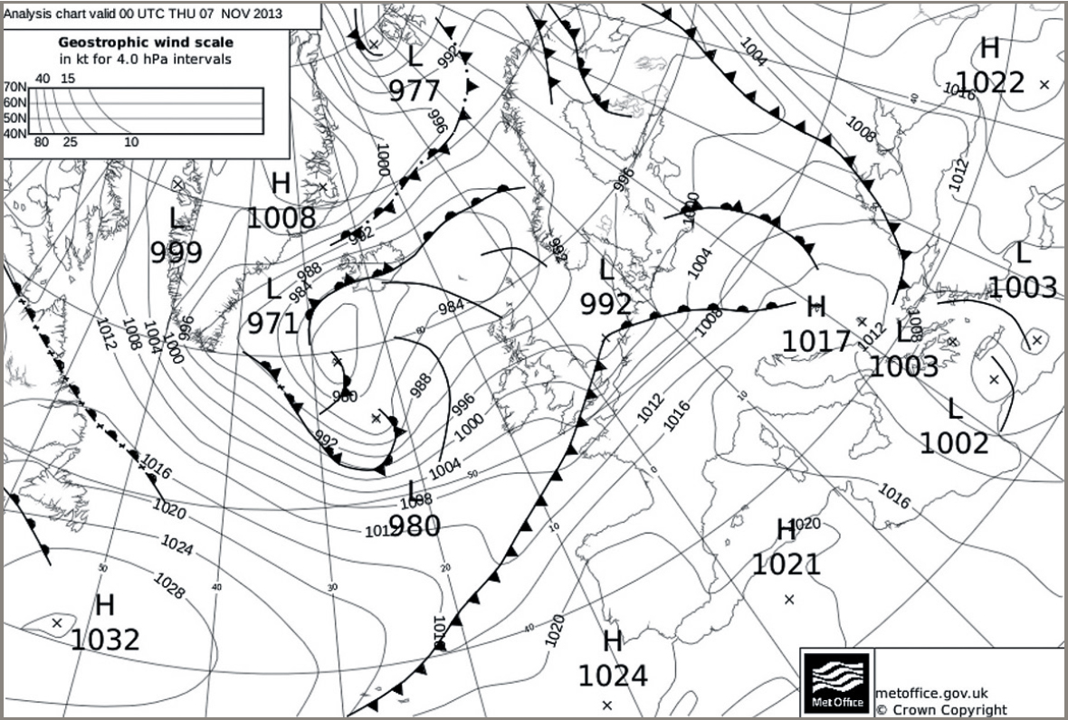
A synoptic chart downloaded on to an iPad via the Met Office website. Scotland and Ireland have had a reasonable day. For the English Channel things seem to be finally looking up as the cold front sweeps away the warm sector that has spoiled a late-season’s day on the water.
HIGH PRESSURE
Generally speaking, high-pressure circulations are larger and more slow-moving than ‘lows’. They often bring settled weather, though at certain times of year this may be accompanied by poor visibility or even fog. High-pressure weather typically favours the formation of sea breezes (see below).
| SKIPPER’S TIPS | The isobar squeeze |
| It’s not unusual in summer months to find yourself in an area of strong winds, with no particular weather system in the offing. This may be caused by a squeeze of isobars. It’s most likely when you are situated between high- and low-pressure centres, neither of which is going anywhere particularly quickly. The winds generated can be strong and stable, giving near-gale conditions which continue for days out of a maddeningly clear sky. | |
FOG
Two types of fog are of interest to the Yachtmaster. The first sort, which creeps into harbours overnight in spring and autumn, may well turn out to be land fog. This forms over chilled fields and river valleys under cold, clear skies during the hours of darkness. Usually, the sun ‘burns it off’ soon after it rises, and even if it doesn’t, there is every chance that the fog will not persist far out to sea.
Far nastier is the sea fog generated by warm, moist air meeting colder seas. The classic example of sea fog is created when the tropical maritime air brought up the North American coast with the Gulf Stream meets the arctic Labrador Current in the vicinity of the Grand Banks of Newfoundland. The cold water lowers the temperature of the moist air until some of its water vapour precipitates out in the form of fog. Depending on the consistency of the water temperature and air condition, such fog can form in seemingly endless banks, or it may appear only in occasional patches. Often, it fades out in the lee of a headland and sometimes it can even be affected by the turn of the tide.
SEA BREEZES
Land warms up more rapidly than sea for a given heat input. It also cools down faster. As a result, on a hot, sunny day, in quiet ‘gradient’ wind conditions, hot air will begin to rise over the land towards lunch-time. Cooler air moves in off the sea to take its place, creating as it does so a sea breeze over inshore waters. If there should be a light or moderate onshore gradient wind in addition to the conditions described above, the sea breeze will add itself to this, making up a strengthened wind for the period of its duration. Should the gradient wind be running offshore, the sea breeze will be subtractive, possibly knocking the airflow out altogether.
Sea breezes in temperate zones are usually at their most noticeable in spring and early summer, when the ocean temperatures are substantially lower than those built up during the day ashore.
A converse effect to the sea breeze is sometimes caused by the land cooling rapidly at night while the sea maintains a more even temperature. If the land falls below the heat of the sea, air rising over the water is displaced by cooler air flowing off the land. Such effects are generally less dramatic than the sea breeze of the daylight hours, but it can still produce some fine gusts off steep headlands with high ground behind them.
Sea and land breezes are essentially local affairs. They can sometimes be felt five miles or more offshore, but they may fizzle out within the first thousand yards. They are, however, predictable to the local sailor with his eyes open. Many is the time I’ve drifted in the West Solent around 11 o’clock on a May morning, waiting for the fine southwest breeze that I knew would carry me as far as Cowes. Whether it would hold into the East Solent and on towards Ryde was another matter altogether, but if I could work down as far as Hayling Bay before the sun set, I could safely bet there would be wind aplenty being poured off the open Channel to cool the suntrap of the hot, flat fields around Chichester Harbour.
SIGNIFICANT LOCAL WINDS
While winds in northern Europe and the North East and North West coasts of America tend to be fairly random within the framework of the weather systems described above, other zones are notable for significant local winds. Many of these have colourful names, and it is a negligent sailor indeed who navigates the coasts of Western Australia without a nodding acquaintance with the character of ‘The Freemantle Doctor’. The Mediterranean specialises in spectacular winds of considerable force that can make or break a passage, a holiday or a charter business. All Yachtmasters operating in such areas owe it to themselves and their crews to know about their local winds, what triggers them, how long they are likely to last and what actions to take when one is imminent. An example is the way in which the ‘North Wind Sector’ of a circulating low-pressure system in the Gulf of Genoa is likely to crank up a Mistral, which comes thundering out of the mouth of the Rhône to command the whole attention of the Western Mediterranean for five days or more.