
Chapter Two
The Design Process and Site Establishment
The design process is the starting point—if there ever is a discrete point of initiation—for making a regenerative and resilient place a reality. It’s probably more accurate to say that the design process is the period when we spend more of our time focused on what we should do (goals), what’s possible (analysis), and how to do it (the plans) than at any other part of the thinking-making continuum. The boundaries of the design process include any observations, drawing, photographing, conversations, and hard plans that one engages in during the development of a place.
It is essential to remember that this process does not stop once the shovel hits the ground. Designing is a constant state of being, and when engaged in the world as a problem solver, you never turn off the tendency to notice a suboptimal situation and think systematically about how to improve it. Design processes can take many forms, and no one approach can be prescribed as the best for all people in all places at all scales. However, it can be said that any effective design process is rooted in intense engagement with the problem at hand and the world in which that problem resides. This is often where “modern” design fails; while the problem may be engaged, the world in which the problem lives is often ignored. This, of course, is a logical consequence of the modern “designer” being someone that works inside a building called a studio. The designer, if she is worth the tracing paper she uses up, is someone digging in the dirt, talking with the neighbors, sitting quietly waiting for the sun to rise at daybreak, and embedding herself in the subject at hand (which is always a place) in countless ways. This section offers a brief account of the approaches and frame of reference I have employed to think clearly about and activate functional human habitats.
Planning and Design: Observation before Action
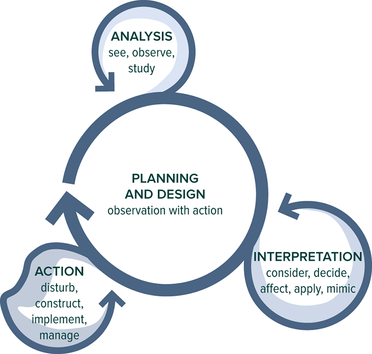
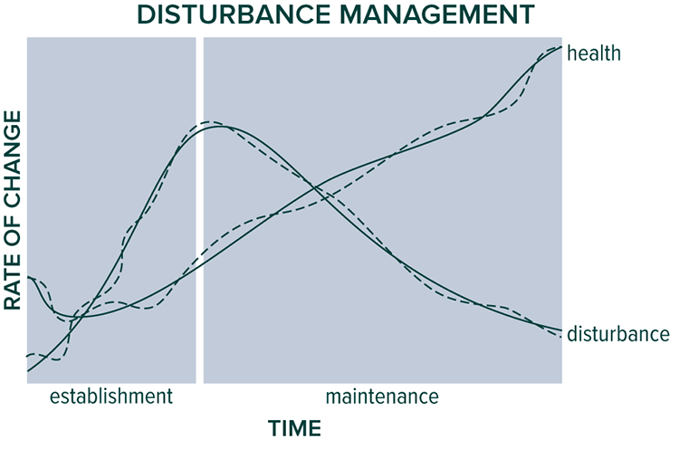
Site planning should be continuously fed by a never-ending process of analyzing, interpreting, and acting. Illustration courtesy of Whole Systems Design, LLC
When beginning to plan a project and the establishment of systems, the primary task is imagination. We must envision what the site could be like—and should be like—in one . . . five . . . twenty . . . a hundred years hence. Taking the time and mental space needed to do this both in the beginning and repeatedly as the site unfolds is crucial; remember, site analysis is never complete because the site is always becoming something new with each passing week, month, year. So when I say “should” be, I mean an intention that is open to new information coming in as the site unfolds. We must be able to both intend a site with will power and listen to the site as it evolves—both, not one or the other alone.
The Designer’s Set and Setting
Successful problem solving is based to a large extent on the designer’s learning environment. As those seeking to be adaptive and successful in the face of a world in constant flux, we are all designers by definition. We are all problem solvers. As problem solvers we must be several things, including:
• An observer: We must notice what is happening in the world around us, both immediately at hand and globally. This awareness must observe patterns in both physical conditions (space) and events (time). And the extent to which we notice and “see” is highly dependent on what we know and have language developed for. Seeing clearly is also dependent upon acceptance and a constantly repeating initial nonjudgment of what is happening around you. Clear analysis depends on seeing things as they are—jumping to thoughts about why something is present or why a process is happening the way it is clouds a clear vision of what it is.
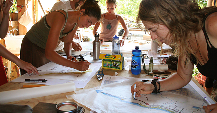
Students in the Whole Systems Applied Permaculture Design Course working on their schematic designs.
• An interpreter: As we notice patterns we must be able to translate that raw data into intelligent hypotheses and strategies for action. The ability to perform this “if-then” part of the design process is enhanced especially by associative reasoning skills and direct familiarity with ecosystems and how they function across time. One can think of this part of the process as ecoliteracy§§ in action. It’s also important to understand leverage points and how to get the most result for the minimum effort—ecosystem management tai chi or utilization of Buckminster Fuller’s “trim-tab” principle.¶¶ Since there is always far more adjustment to the system than we have time or energy resources to accomplish, the designer’s task occurs in a constant state of prioritization—of tweaking the trim tabs to adjust the movement of the entire ship using as much leverage as possible. If, for a moment, you think the system is complete, done, perfect, you haven’t looked hard enough—there is always optimization that can be facilitated.
• An activator: Following identification of a need or challenge and the interpretation of how it might be met comes the action part of the process—the digging, planting, hammering-nails phase. This requires mental and physical skills, patience, good judgment, pacing, the ability to work smart and apply our physical force via our bodies or other tools (including machinery) to the project. As we engage in this work, it is important to do so with great awareness; don’t fall into the easy trap of lowering the head and forgetting to look up from time to time to see how the work unfolds.
Actually, it is only during this activation phase that the true accuracy of the identification and interpretation phases begin to become known. As we hammer nails and raise the walls of a house, we start to see if the design was a good one. As we look back at lines of plants in the ground, we begin to know more completely if they are truly in the right locations. So begins the cycle of think-design-do-reflect-redesign-do. It’s a never-ending cycle—in the realm of living systems, no design is ever complete. Plants grow, soils build and change, animal habitats change, and people shift in interest and available time and capacity. The entire system is always in a state of flux, with all parts moving relative to both the larger world and to each other—like one giant mobile rotating upon itself in the breeze. To function intelligently and with some level of mastery, we must always be willing to look up, stop, take a breath, and reassess.
Indeed, the clearest measure of the value of our approach in regenerative systems development only fully emerges over the course of years, as tree crops mature, as soils become what they can be, as populations of insects, fungi, and animals interact with the system. In year one we know little; by year five we know something about the system, but not until year ten or twenty can we start to draw conclusions about much of how the system functions. And a few decades in, if we are ready to be surprised, to be wrong, we will continue to learn. Eventually, if you are actualizing yourself in your place, you become the world’s foremost expert on how to help make that place work—on what it was, is, and can be—and how to get there.
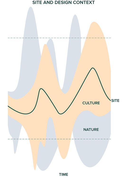
The site should be evaluated as the product of natural and cultural conditions across time. Graph courtesy of Whole Systems Design, LLC
The ideal design for a site is never static and is always evolving according to such constantly changing variables as
• Human resources available
• Climate
• Soil conditions
• Succession stage of ecosystem on site, including maturity of plants and animals
• Outside resources available off-site: money, materials, energy
• Off-site social conditions: stability of society, needs and desires of neighbors, people in the region and beyond—movements in “the market” at large
Site Establishment Leverage Points
Since time, money, labor, and other forms of energy are always limited in some capacity, we must always be seeking the most powerful ways of effecting regenerative change in a landscape. The regenerative land worker’s routine must always be guided by finding those methods that offer the most influence for the least input, since it is these inputs that are limited. Compiled below is a list of the top five leverage points I have found in cold-climate regenerative agroecosystems establishment and maintenance. These are the strategies that offer the most potent positive impact relative to the smallest energy and time input (most of these usually happen most optimally in concert with one another). These actions should be seen as the land worker’s primary tools for change making:
• Swale construction and fertigation via swales
• Grazing animals, especially large ruminants and chickens
• Broadcasting seed and planting live plants
• Cutting and clearing trees
• Scraping and tillage: mechanical bare-soil creation by hand or via bulldozer, excavator
Recall these primary approaches as you attack any land-based problem on your site, and remember, too, that they are only those I have found most essential. There are other important succession-altering tools I have found extremely useful, such as fire, but that are not essential enough to fit within the first edition of this work. Stay tuned to the next edition for elaboration on these techniques and the likely inclusion of others that are emerging on this farm.
Ecosystem Management: Steering Succession
The area of the world I live in wants to be forest. Fueling a merino wool gold rush, a timber rush, and the charcoal (metalworking) industry, 80 to 90 percent of my home state of Vermont was cleared of its forest only a century and a half ago. Yet without replanting it is nearly entirely reforested today. We are fortunate to live in a place and time where the right combination of moisture consistency across the year and temperature patterns promote the establishment and growth of trees on all surfaces of the landscape except on the steepest cliffs and open water.
From the homesteading and resiliency perspective, however, today’s forest cover is as optimal as its composition and health are natural; that is, simply because the forest is here does not mean it is inherently healthy or optimized in terms of species composition, stocking density, species health, or soil and water health. Today’s New England forest is simply the result of the succession taking place in the wake of the nineteenth-century abuse and abandonment. Species such as chestnut were replaced with white pine in this landscape change. Precolonial forests also contained a much higher concentration of black walnut and other mast-yielding trees, in all likelihood because of the native human presence on the land, during which specific species were promoted—those that fed people (directly) and wildlife (indirectly) the most were selected for. Think of Johnny Appleseed’s work being applied across a range of productive species by a million human beings over at least a few thousand years. In this perspective it’s not hard to see how the forest was so vastly different from what it is today.
Every site is a response to past disturbance forces. Our task is to make conscious those disturbances and steer the system’s response to them in such a way that the outcome is as biologically complex and productive as possible.
For example, the Northern Forest cover type today contains a lone nut-bearing species, the American beech (Fagus grandifolia). Nut trees produce more fat and protein per acre than other trees and therefore can grow more wildlife per acre and distill sunlight into a more potent value. For those interested in producing the most resources (outputs) with the fewest inputs possible, the imperative here is clear: We need a greater percentage of the forest to be composed of nut-bearing trees. We also need to develop those land-use systems that may in fact not be forest, if and when they convert more sunshine and rainfall into potent values than forested land does.
It turns out that intensive rotation grazing has a uniquely high ability to convert subsoil to topsoil and, in the process, sequesters more carbon from the atmosphere into the geosphere (as organic matter) than any other cropping system. We are beginning to realize synergies between such grazing strategies and permanent tree cover and recognizing the wisdom inherent in millennia-old food systems such as the Spanish dehesa system, in which animals are grazed in and around an open forest (woodland), with yields of timber, nuts, soil, meat, and even milk all overlaid on the same piece of land. We now call this approach silvopasture to indicate the simultaneous growing of trees and animals. It is becoming increasingly clear that much of the cold-temperate climate landscape should be in some form of permanent silvopasture. (See chapter four on grazing systems for a more in-depth look at silvopasture strategies we are employing in particular.)
Simply because a piece of land is currently forested does not mean that such a forest is optimal for the health of the ecosystem or most productive for the human members of that ecosystem. This idea is strong and pervasive—and one that I had for many years when I spent more time in the academic study of land than in daily interaction and participation with it.
We must confront the myth of the “natural” and the tendency to call something natural simply because it seems to exist free of human management. A regenerative agent in the system must take his vision beyond this snapshot and romantic image and see the current landscape as simply one ecological succession unfolding, one scenario among many possible, which happens to be the result of past disturbances and the particular events occurring immediately after these events. Permaculture, in this view, can be thought of as applied disturbance ecology. What disturbance forces have been at work on this landscape in the past? What species have been filling niches as they open and why? What would the most optimized landscape here look like in terms of ecological and human health—what is configuration of water flow, species composition and their arrangement? What changes (disturbances) are needed to evolve the current system to the more optimized one?
Disturbance forces include:
• Cutting vegetation (low or high on the trunk) or uprooting vegetation
• Grazing, human foot traffic
• Tillage/excavation/removal/scraping (by machine or animal)
• Fire
• Seeding
• Flood
• Drought
• Heat and cold
• Wind
• Pollution, chemical
• Pollution, radioactive
• Pollution, genetic (disease, GMOs, mutational)
These are most of the tools at our disposal with which we can modify the direction of succession in a place—not that we want to use the last few, mind you. Those of us in a forested region of the world must start site development with design questions that include these: What aspects of the existing forest cover are functioning toward resilient, regenerative, and productive ends? What species, what characteristics of the water flows, human interaction with the system are most limiting to the promotion of a more diverse and biomass-producing condition?

Foundational to the design process is an understanding of the inherent potential of the existing ecosystem and what the site ultimately “wants” to be. Illustration is not to scale. Illustration courtesy of Whole Systems Design, LLC
Resiliency and Regeneration Principles
While giving a tour of the research farm recently, I stopped by the rice paddies, as I do on most walks of the farm. A student in the group asked questions I hear often: “How often do you water the paddies, how deep should the water be, and how do you know when to add water?” I began to think of the answers, and within seconds was inundated with various potential answers. I almost began to provide what have been the varied answers to these questions, including the state of the rice; the temperature of the day; the past days’ weather and the forecasted weather ahead; the time of the season; the condition of the rice as evidenced by color, size, and overall vigor; how busy I am; and many other factors. Then I realized that all I could say was, “It depends.”
What to do in a given situation when working with land always depends on the conditions one is facing, and the conditions are always myriad. Those conditions are also in a state of dynamic flux. This is acutely challenging for most people who are products of the industrial schooling—often an unlearning—system, which trains people to follow discrete sets of instructions when addressing a problem. Life, people, and the relationships between them, however, are far too complex, dynamic, and nuanced for rote instructions to be effective most of the time. Habit is not sufficient to solve problems, though it can be useful; it must be coupled with awareness and novel responsiveness to novel conditions.
The land system is not a machine—it doesn’t function in merely mechanical ways, though it is in part mechanical. This is probably why people are easily confused and end up habitually managing land as they would a machine. The rub is, however, that it also functions in far more complex ways beyond the patterns of a machine, or nonliving system. The land system is alive; thus, in a constant state of flux, evolving, responding, adapting, adjusting. It is never the same thing from one month to the next, one day to the next. Thinking it is the same thing leads us to conclusions that are at best ineffective, at worst dangerous. Relating in a way that truly appreciates and accounts for the complexity of the living land system is not mysterious or difficult—it is no different from relating to another human being. Healthy people recognize the complexity and changing nature of other humans: We wouldn’t say the exact same thing to one another every morning over breakfast, act in the same manner to one another each day, year to year. Of course not, as people’s needs, desires, and overall contexts change. Healthy interaction is responsive—always based on the conditions of the moment and on past patterns and future goals.
Healthy interaction is dynamic, elegant, soft, improvisational, but not robotic. Most of us know this on a human-to-human level. Yet when it comes to land interactions, we tend to think repetitive actions are appropriate, as if the land system is the same from day to day, year to year. Truly, at its root, the idea that we can figure out some aspect of the land system and think that management needs should stay the same from year to year is insane. No complex system works that way—and such an approach is completely blind to the in-flux nature of reality as a whole. Modern industrial schooling and the unlearning process it tends to facilitate are highly effective at patterning people to act in this way, however.
The following principles and strategies represent some of the guiding directives that I have identified in the work I have been practicing. The list is not complete—therefore, please do not be limited by them. There are dozens more that apply less often in my practice or that I have left out for brevity. There will likely be many directives that need to be identified in your own endeavor that do not appear here—especially if your climate, scale of work, focus, and other contextual aspects vary significantly from my own. The process of discovering these directives is a rewarding one, and I encourage you to continue that journey in your own life; it’s a personal one, and the only way to amass plenty of clues in this process is by getting your hands dirty. Enjoy the process!
Resiliency and Regeneration Design
1. Maximum Outputs for Minimum Inputs
The optimal system yields the most value—in quality and quantity—with the fewest inputs. Our task always involves maximizing the ways to grow the most value while reducing dependence on off-site resources to do so.
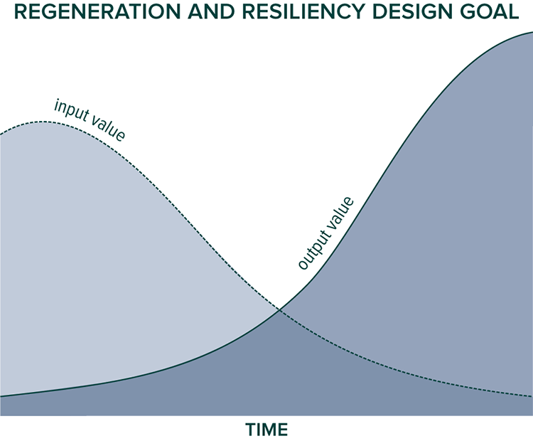
Maximizing outputs while minimizing inputs across time
2. Transform Dead Matter into Living
Regeneration relies upon the upcycling of matter, ultimately based upon a foundation of bedrock, atmosphere, water, and the elements. Our task is to facilitate the conversion of rock to soil, soil to plant, plant to animal, animal to soil. And the cycle continues, each time accumulating a net gain in value—with more organic matter existing than the round before. In this way we can think of the entire regenerative land-use practice as an attempt to transform inert material into as much living, breathing, organic material as possible—the earth itself as one huge compost pile upon which we grow.
3. System Establishment versus System Maintenance
The needs of a site during the early months and years of establishment vary greatly compared to the needs of the system over decades and centuries. It is often sensible to use tools, materials, people, and other resources in the present moment for system establishment that may not be available or desirable in the future for system maintenance; for example, an excavator to make rice ponds or paddies.
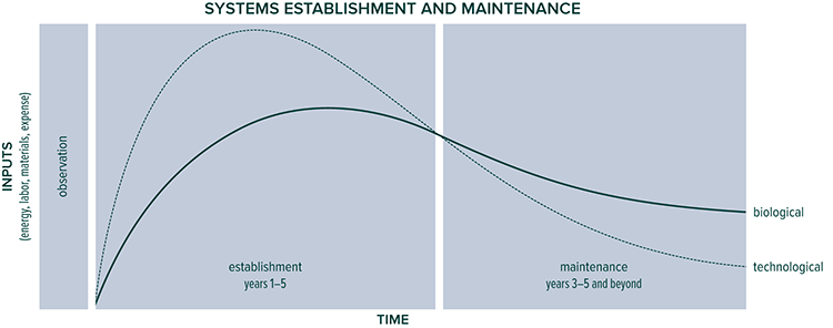
A high level of inputs is needed during the establishment phase to create a sharp rise in the biological activity and infrastructure that will last and add value over time.
4. Biological Complexity, Technological Simplicity
Resilience is greatest when living aspects of a system are complex, diverse, and connected, while the nonliving aspects of the system are simple. This is rooted in the fact that technical systems are constantly prone to entropy and are always moving toward failure, whereas living systems actually tend to build higher levels of order over time. Living systems amass sophistication, durability, and productivity. As resiliency seekers we aim for a system in which ever less time and energy are spent on infrastructure maintenance so that time can be dedicated to cultivating and optimizing the living systems on-site.
5. Resilience = Diversity × Redundancy × Connectivity × Manageability
The ability of a system to recover from disturbances is highest (1) when the system is composed of a high diversity of elements; (2) where there are backup elements to all crucial components of the systems; (3) where the connections between each component form a web with as many connections and modularity as possible, but (4) where the system is simple enough to be legible, manageable, and accessible for human participation—where the system’s needs for optimization do not overwhelm the capacity of the human occupants to help meet those needs.
6. Regeneration Metric = Biomass and Biodiversity
Though impossible to simplify into any single formula, the most concise way I have been able to define whether an action is regenerative or not is to evaluate the answer to the following question: “Is the action increasing biodiversity and biomass?” Conventional farming, of course, is focused solely on biomass production, while conservation biology and ecological restoration is focused on biodiversity preservation and increases. Permaculture aims to increase the interdependency upon each other.
7. Facilitate the Vital Force
No hard line exists between living and dead matter. There is an animating presence in all living beings that seems impossible to isolate. This animating force makes regeneration possible, and our work is always to encourage its expression and to align ourselves with it, to receive its gifts—for the force is abundant and what it provides are most accurately described as gifts.
8. Human Management = Primary Limiting Factor
I have found that even on just ten acres, space, soil, water, infrastructure, and skills do not constrain the optimization of the site more than the capacity of the human inhabitants of the site to provide time, labor, and awareness services in the development and maintenance of the site. This principle is closely connected to Bill Mollison’s “yield is theoretically unlimited” statement. Indeed, the yield of a system, since it is the synergistic product of air, water, soil, and many other components, is not limited by any one, and only one component leverages them all together—human management.
9. Stress as Stimulus
We are after the rhythm between rest and stress that promotes the most biodiversity and biomass.
10. Responsiveness, Not Habit
As mentioned in other areas of the book, the most effective actions, though sometimes stemming from positive habits, are not limited by habit but are informed by habit. Such habits promote awareness. This awareness allows us to see what novel ways of responding to conditions are required. Responding to new and emergent conditions (always the case) demands that we can act in ways we have never acted previously.
11. Human Resource × Site Characteristics = Ideal Site Design
An “ideal” site design, though hypothetical, is a useful goal. This selection of elements and their positioning in the landscape is never the same from site to site because they must be wholly responsive to conditions (of both humans and nonhuman components) that always vary from location to location. Therefore the “ideal” design must be completely referenced from the site’s characteristics and the human resources in place, which include number of people, interests, skills, ages, and other factors. Give five groups of people the exact same site, and their five designs should not be the same—no one design is correct in such a situation—and the best one is so because it is suited in part to the humans inhabiting the place, not just the other site conditions. In this way there is no “correct” design for any one site. What’s true for you is going to be different from what it is for others. Plan on it. So don’t simply copy another’s approach thinking it will give you the same results, as, likely, it won’t.
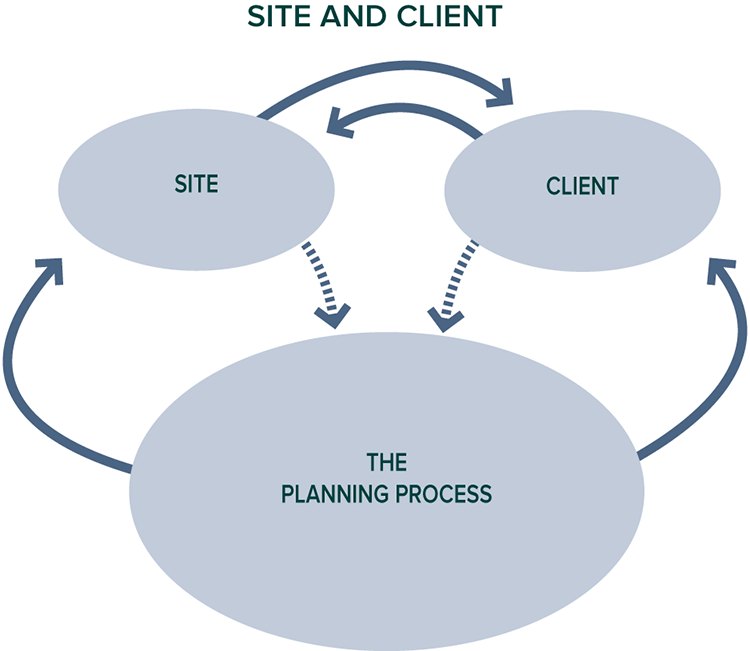
Both the site and the client feed a planning process that in turn feeds back into the site and the client through implementation.
12. All Design Should Be Modular
Since the future of both land and person(s) is unpredictable and guaranteed to change, good design and developments must be able to be added to, subtracted from, moved around, and adjusted constantly over time.
13. Structural Diversity Begets Biological Diversity
Biological diversity is often most limited by the physical three-dimensional structure of a space. This is a commonly cited principle in marine ecology that is highly visible in the example of a sunken ship landing on a bare sandy sea floor. Life flocks to such a situation where little existed before. So, too, is this phenomenon in effect in terrestrial systems seen especially at the edge between field and forest, in swale-mound systems versus flat fields, and other situations where three dimensions of complexity exist rather than simply two. Promoting this positive effect encourages us to develop structure, whether it is buildings, swales and other slope elements, trees within fields, or other such spatial changes. Organisms exploit edges and structure constantly—when you add structure you see the results quickly.
14. Habits of Mind
The outcome of any action is highly determined by the mental frame of reference used by the actor. One has the power to shift this without dependence on outside events, people, money, or other resources, so one’s own attitude management is highly empowering.
15. Spread Pulses
The most resilient systems spread intensities across time for maximum value absorption into the system. Examples of this include slowing, spreading, and sinking water via swales, terraces, ponds, and paddies; thermal absorption in high-mass materials such as stone and water for release when ambient temperatures are lower; fertility spreading via keyline ditches from concentrated areas such as barnyards to low-fertility areas; and delayed processing in the harvest season when crops can be put aside for processing because time is more plentiful.
16. Disperse and Extend Fertility
On all sites there are zones of nutrient concentration and/or high productivity. It is the job of the regenerative designer-maker to spread such fertility from areas of concentration to areas lacking fertility. This strategy includes both dispersing fertility across space and extending fertility across time; for example, space: biomass harvested from a productive pasture moved to feed animals while they are in less fertile paddock; and time: using humanure/urine generated in the winter to water and feed plants in the growing season. This principle ties in closely with the principle of spreading pulses.
17. Land as Value Distillation Tool
The land system as a whole and all elements in it (including people) is useful to view as a tool for concentrating the most beneficial yields, including medicine, food, fiber, materials, and fuel. A landscape should be thought of as a net that is constantly being cast, through which the gardener–farmer–solar energy angler reaps the most positive interactions among sunshine, soil, rain, wind, plant, animal, and fungal activity. The regenerative and resilient designer-maker is a facilitator in this interplay between forces, the overyield of which can be stored, shared, and accrued as fertility to be cycled (banked) back into the system to continually bolster the principal over time. With the principal constantly being increased, the interest (yield annually) offered by the system can also continually increase over time.
18. Multiple Functions from Single Expenditures (Always Do or Get Two or More Results)
A primary permaculture principle—all elements and actions/processes ideally always yield more than one desired result: A duck fertilizes, reduces pests, and makes eggs and meat; urinating outside allows you to see the status of a plant, health of an animal, or a pest eating your basil, while offering fertility to the site. If anything you are doing seems to yield a single result, closely evaluate if there is not a better way.

Every element of a system should serve multiple functions; a duck fertilizes, reduces pests, and makes eggs and meat.
19. Moving Things Is Entropy
It’s easy to get multiple results from some single actions—think of planting a tree: You’re fertilizing the soil, weeding, inoculating, being healthy, and putting a new plant in the ground all at once. Moving something from one place to another, however, tends to yield less value than it costs in time, energy, or materials. Hauling a bucket of water from one spot to the next or driving a cord of wood from one area to another offers little benefit except the result of a material in a new location. Simultaneously, it carries a cost of energy, time, and usually money being spent while compacting soil where one walks, potentially hurting one’s back, killing something in the path or road, and so on. The most optimized sites reduce wherever possible the need to move materials from one place to another. Where moving needs do exist, they are done as passively as possible. Granted, we all need to move things actively: I move a lot of firewood, but every time I move firewood, I realize that the same effort I put into such a task could be applied to tree planting, soil inoculating, plant or animal tending, sowing, or innumerable other regenerative actions. Given this reality, it is important to continuously evaluate what you’re moving and why, and how to reduce moving needs so that energy spent there can be applied to more regenerative actions.
20. Value across Time
The most potent values in a system are yielded across the greatest length of time; for example, nut pines such as Pinus koraiensis and Pinus cembra take twenty or more years to begin bearing but yield for four hundred or more years. Plums and peaches bear within five years and yield for thirty to forty years. Nut pines are made up of mostly rich fat and protein; plums and peaches are tasty but offer mostly only sugar and basic vitamins. The best soils in the world weren’t built overnight but over thousands of years. A chestnut can outyield a cow in terms of nutrients without needing any food to be provided for it, but it takes a decade or so to begin bearing, whereas a cow starts bearing quickly.
Examples of durable abundance and vigor in human cultures are always most manifest in examples of people living in close contact with one another and their physical places for many generations. The best things usually require a wait. Working on a longer time horizon than is typical in the early twenty-first century on Planet Earth is crucial to developing individual, community, and land health.
21. Essential Functions Provided by Multiple Elements
If it’s essential, ensure that you have multiple ways of provisioning that need; for example, I can get water from the well via pump in normal conditions; via the well via pump via generator when the grid is down and the generator or pump is broken; via a spring and tubing when the grid is down or via rooftop catchment into barrels; and via a 50-gallon storage tank in an attic or ponds and buckets if all else fails. Barring something too extreme to plan for, I am going to have water.
22. Simplest Solution Is the Best Solution
There are numerous ways to solve almost any challenge, but the simplest approach involving the fewest steps and least energy, materials, and time is always the most effective, long-term, viable solution.
23. Efficiency Does Not Equal Resiliency
Simply because a system transfers energy or materials quickly or with little waste does not mean that such a transfer is durable in the face of shifting conditions. For example, watering multiple five-hundred-foot rows of tomatoes with manufactured fertilizer injected into water and distributed via drip lines is highly efficient at what it does on the farm. Take any one of the inputs needed to make this system work out of the equation, however, from shipment of fertilizer to pumping of water and you’ll see how brittle the system is. Highly efficient systems often actually come to us courtesy of compromised resiliency. Often, we must make a choice between durable, adaptive but somewhat inefficient systems (in the short term) and systems that offer extreme efficiencies in the short run but at the cost of brittleness in the long run. Resiliency necessarily carries with it an extended time horizon.
24. Increase Diversity, Don’t Reduce it
The task of the resilient homesteader is nearly always one of promoting diversity. This becomes particularly challenging when pest issues arise. The conventional response is to remove a biological element when a pest problem occurs—in permaculture we generally try to figure out what to add instead. Asking the question “What eats this?” is often one of the most useful approaches to such challenges.
25. Quality-Quantity Relationship
In general the smallest production system can produce the highest quality yield, while quality is usually reduced as production scale increases.
26. Scale and Proportions Are the Most Difficult
In the design of any space, remember that it is most often the overall size of a space and its proportions that are chosen badly, not the quantity, type, and position of components in the design. It is often very difficult to get the proportions of a space optimal, and a desirable result is a dynamic product because no two spaces are the same: You can’t just copy the proportions from a space you know and have the system work out in exactly the same way in a different location. This is where the “art” of design often comes in. It pays off in spades to get experience into the equation at these junctures in the process.
27. Oil Intervention
As discussed earlier, rather than not using currently available and inexpensive fossil fuel, one can use the existing flow of such a resource to establish systems that do not require fossil energies to operate perpetually. Think of a swale as an example: It requires forty hours of labor to dig, say, two hundred feet of swale or thirty minutes of excavator use and eight ounces of diesel fuel. Not using this eight ounces of fuel (or call it a hundred ounces of fuel with a pro rata of embodied energy in the machine) won’t undo the fact that such fuel will be burned up in other avenues such as by the US military or your neighbor in his SUV making an unnecessary trip to go shopping. The point is simply this: Use it or lose it. Intervene in the oil flow, and apply the potent energy to establish long-term systems. Choosing not to simply means that you’ll be digging for many years and the systems’ overall development will take many times longer than would otherwise be the case. Imagine our children digging paddies and ponds and swales and wondering why we didn’t establish these systems while the digging was so easy.
28. Probability × Impact = Risk
The likelihood of an event’s happening times the severity of that event if it occurs defines risk; for example, economic recession versus a comet striking Planet Earth or getting the flu versus contracting the Ebola virus. Sound planning is risk based.
29. Niches in Time
Good planning and action always make use of an opportunity in time—the “moment.” There is always an optimal time to perform any action—never is it as good to perform an action “whenever.” Often, an action is only appropriate in very small windows of time.
30. Zone 1 Site Mimic
Given that awareness, time, and labor are the limiting factors to maximum realization of abundance and health on most sites, and that many sites are simply too large or complex to tend with complete diligence, mimicking the entire site as much as possible in zone 1 enables the human inhabitants to survey the entire site by inspecting zone 1; for example, planting a few of every species in zone 1 lets you know what is fruiting in more distant zones of the landscape that are easily missed. I often miss the first honeyberries ripening because I have no honeyberry in my zone 1—the only plants are in a zone 3-ish area that I do not frequent. A few “barometer” honeyberries such as I have with seaberry, currant, and mulberry tell me when I need to walk a few hundred yards into zones 2-3-4 with a bucket to harvest.
31. Past Is Precedent
Exceptions to the general pattern of history are rare. When planning actions the regenerative and resilient designer-maker must aim for the highest and most beautiful possible outcomes while simultaneously being aware of the most likely future scenarios. This resilient designer-maker uses history, rather than pie-in-the-sky fanciful visions as a guide in this work.
Resiliency and Regeneration Habits of Mind
32. Good Design Always Empowers
Any system that promotes regeneration, resiliency, and adaptability empowers the human beings, plants, animals, and other forces acting in the system. All good design facilitates the free, conscious, and subconscious actions of members within the system and encourages the manifestation of instinct by all members of the system. Good design allows rather than restricts, encourages rather than suppresses. Good design is suspicious of “rules” and sees regulation as an indicator of an area in need of attention and improvement. This does not always mean that an optimal system is completely nonhierarchical, though in general it is relatively nonhierarchical. Good design always facilitates the manifestation of all the genius latent in each member of the system, and usually, rigid hierarchies do hinder that.
33. Passive versus Active Observation
Permaculturists are fond of the dictum, “Observe, then do.” While passive “observation before action” is necessary, so, too, is observation through action. Much of what is necessary to learn in human habitat development and management can only be learned through experimentation with various approaches over time. Many aspects cannot be learned through passive observation alone, and attempting to figure out a challenge without doing is often impossible. We must begin planting, building, acting to learn about the system more thoroughly. I learned far more about the soil and its variations on this site in two weeks of planting trees than in three years of observation through walking and looking. In retrospect, this should not be surprising—getting one’s hands on the material at hand (soil, plants, water, and so on) is the most direct route to actual seeing. This should not discourage deep detective inquiry through reading the landscape’s plants and other ecological indicators, but should remind us of the limits of indirect contact.
34. Observation Action Chronology
In reference to the previous principle, it is important to note that the most irreversible actions should be conducted following the most passive observation while the most changeable actions should be conducted earlier in the development time line.
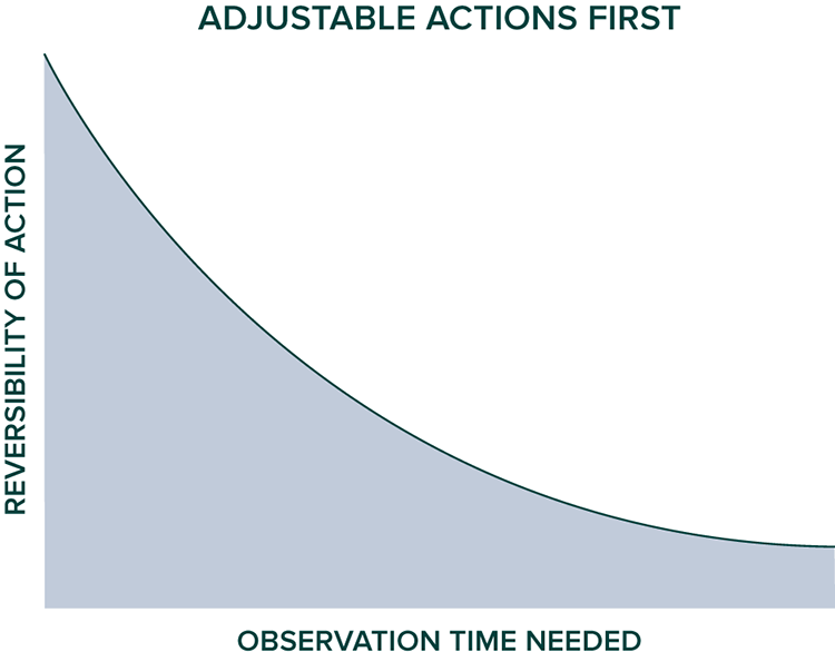
The most reversible or changeable actions should be carried out earliest in site establishment, while the most irreversible should be carried out after more passive observation.
35. Two Is One, One Is None
Elements fail; crucial elements must always be backed up. Things fall apart. Rust never sleeps. Entropy is. If you need it, back it up. Ensure that it is redundant and, ideally, alive; for instance, the most durable food storage is chickens in the yard, cows in the barn, vegetables growing in the garden, kimchi in pots underground.
36. Character of Work over Time of Work
When deciding how to allocate time, it is easy to forget that the type of work involved in a task is often more important than the time needs of the task; for example, digging holes for a couple of hours is less desirable work for most than splitting wood for four hours; pruning for a day is more practical a task than hauling slash for just four hours. In general, heavy, dirty, or toxic jobs should be planned out of the equation as much as possible in place of jobs that may require more time but less brute strength. Personally, I’d rather mow with a scythe for half a day than run a weed whacker for two hours, for instance, all things being equal.
37. Immerse in Abundance
The vital force tends to produce abundance. Since our task is to facilitate this abundance, we must immerse ourselves in it to know it, to encourage it. Immersion in abundance also serves to expand our perspective and allows us to work from a frame of “enough,” not of scarcity. When we work from a reference point of scarcity, there is never enough to go around. Without harnessing abundance as our guide it is unlikely that we will cultivate truly regenerative and resilient systems.
38. Maximize Site Awareness
Take advantage of all opportunities to increase sight-line distances and clarity of that distance. The area that you can hear on a site and the acuity with which you can hear activity in this area is of crucial importance to managing a site well. And all ways of sensing what is occurring on the site at a given moment are helpful. See expanded explanation of this principle in the grazing section of chapter four.
39. Embedding Skills and Practice in Daily Routine
Life gets too full and time too limited for all the important skills of a land-based lifestyle to be practiced enough if they require many hours of practice in addition to daily needs and chores. Therefore, integrating the skills we’d like to develop into the regular daily rhythm is crucial to actually practicing them. This occurred to me clearly one day as I found myself in the middle of a few-week period of making my morning coffee on a mini wood cookstove that I use for camping and emergencies. I made the fire with a fire steel using no match or lighter. This took maybe a minute longer than it would have with a lighter but allowed me to practice an important fire-starting skill while accomplishing a normal daily task. Such rituals can also be highly satisfying.
I have found similar opportunities to embed skill development in my daily routine and always seem to find that they often take a little longer than the easiest, least skill-intensive method but far less time than dedicating specific nonroutine time to them; for example, taking an hour to work out when I can haul firewood by hand instead of using my truck or jogging to the mailbox instead of driving. This principle is also connected to the concept of designing in challenges to one’s daily life, such that vigor and skills are maintained during the day: I use ladders instead of proper staircases to go between floors in my studio-shop. Sure, stairs would be easier, but the steep ladders keep me more nimble, healthier, and probably happier, too. Ease should not always be the goal, and it is often actually counter to maintaining the most vigorous, aware, and satisfied existence. This is not to say that having easier backup ways of getting around in the case of injury or friends and family to help would not be a good idea.
40. Skills = Most Durable Resource
Beyond land, tools, money, even friends and family, your own skills—including those soft and hard—from growing a potato to making a friend, are your most dependable asset. Your land may be taken from you or your job downsized. Some of your friends and family will certainly leave this life. Your tools will rust or break and can be stolen or lost. But your own aptitudes are there for you to rely on no matter the condition of the world in which you find yourself. And with the right skills you can make every other resource from the world around you. Skills are the foundation on which the rest of your life value is cultivated.
41. Awareness Limits Action
Action is only as productive as one’s awareness allows. You can’t do more than you can see, hear, feel, know. Therefore, sensing as much as possible is key.
42. Environment Limits and Manifests Action
In the same way that ecological succession is informed by the seedbank available, disturbance forces acting upon the site, and other factors, so, too, does personal mental evolution depend on factors in the environment. We need to stack those factors such that our design aptitudes are enhanced over time. In this way we need to be our own continual health-care (mental included) practitioners. Our surroundings limit or empower our minds. The resilient and regenerative homesteader therefore must enhance her own surroundings for her to actually be able to carry out the work of imagining and implementing positive solutions. A poor environment retards this ability.
43. Solutions = Alignment
Solutions tend to emerge from alignment with, not opposition to, forces—not from resistance but from transformation. This is how water works.
44. Figure It Out: Try Stuff
Many of the most needed solutions and approaches have not been figured out, and if they have been, they have been in different places, periods, and groups of people. We each need custom solutions specific to the uniqueness of our lives and places. These always vary. Because they vary there is no instruction book we can follow to gain all the necessary solutions. Trying a wide variety of approaches is crucial to finding the best solutions specific to your unique situation. Fear and lack of confidence retards this. Be confident. Try stuff. Those who have figured out important approaches most often happen upon them by simply trying a variety of tactics.
45. Miracles Everywhere
Stepping back for a moment amid our daily routine, we can sometimes see that each flower, each animal, raindrop, and breeze, is itself actually a miracle in disguise. I say “in disguise” because our minds tend to quickly come up with answers as to why and how something exists—whether it’s the moon, a rainstorm, or a snowflake. Yet when we probe and trace the lineage of anything as far as we can, we indeed find that each thing is linked to every other thing and a source for each thing cannot be determined. Everything arises, emerges. At its core this seems clearly unexplainable, both in scientific and other terms. The practical implication here is clear: the moment we believe that we have the full explanation of why something happens is the moment we begin limiting our vision as to the phenomena at hand. Remembering that we are only seeing part of the vast and mysterious processes underway in each phenomena around us actually allows us to see, learn, and do more as designers. The concept of miracles, therefore, is a highly practical one.
Food and Fertility
46. Constant Organic Matter Accumulation
Aiming to build soil fertility and nutrients, suppress weeds, decrease drought vulnerability, and produce a constant stream of garden soil, the homesteader and farmer should be in a constant state of collecting organic matter. We harvest from neighbors’ driveway edges when the leaves build up in the fall, from under pine stands for the blueberries, from local arborists when they’ve got a truck loaded with chips. Any and all sources of organic matter are good as long as you ensure a low level of toxicity in the material.*** You can never have too much compost.
47. Paths as Biomass Producers
At more than very small scales in cold-temperate climates, paths will eventually be grass and other herbaceous plants—even if they start as gravel, woodchips, or even pavement. Such pathways should serve as biomass and soil production for other areas by composting and mulching with harvested plant matter and then composted or used as mulch in specific areas around perennial plants.
48. Seed Often and Lightly
Since successful germination of seed in land renovation requires consistent moisture (not a deluge or a drought), the most successful strategy we’ve used is to seed lightly but very often in land renovation/enhancement work. This means we seed starting in late March—frost seeding of clovers—even while snow melts back. We continue to seed areas that are in poor condition (abused and abandoned) from three to ten times per season, aiming to seed especially before July, when seed can best establish and moisture is most reliably available.
49. Passive Forage-ability
The entire landscape should be managed as an intensive foraging zone—this means “stocking” the site with the most multifunctional beneficial plants (and fungi, sometimes even animals) (a) for which the habitat is made, structurally and biologically; (2) that are managed to balance as an overall system and maximize biodiversity and biomass; and (3) that are harvested passively while one moves through the landscape doing active or recreational activities. The most productive sites relative to the amount of inputs needed into the system offer yields to the forager within the landscape; one does not need to find food only in a garden bed or planted perennial zone. As an edible ecosystem matures, human food self-seeds and begins to colonize the site even in areas where it was never planted or sown. In this way there is human-ecosystem coevolution occurring. This relationship should be fostered wherever possible.
50. Plant as Densely as You Can Afford To
Because plants sometimes die and you can’t go back in time, in addition to the fact that trees are much faster to cut down than to grow (you can get intermediate yields from dense systems before thinning), plant as densely as possible, with thinning happening later on. This is no different from seeding two to three or more times the vegetable seed you need in a bed and thinning the extras. Seed is cheap and you can save your own.
Plants can be as well. You cannot go back in time and put a thirty-foot walnut in where one died, in between two walnuts twelve years after planting when they were spaced forty feet on center to begin with. We try to plant at two to three times the “horizon”/final desired spacing with the intent to thin if no one dies in the meantime. We’ll also see yields as the trees reach maturity but before they get too crowded. For example, we plant a bur oak silvopasture system that is ideal with spacings of thirty to fifty feet on center when fully grown (years fifty to three hundred or so) at ten- to twenty-foot spacings. We are already getting nut yields in years five to six and will continue to get some yields, most likely, for another ten to twenty or more years before thinning is needed. And then we’ll have nice oak posts or other building materials.
51. Animals above Plants
Because plants are limited by nutrients—especially nitrogen—provided in large part by animals and their by-products, and because gravity never ceases, placing animals above the elevation of crop plants in a landscape is a primary approach to maximizing productivity. The best sites have an access road high in the landscape where a zone 0/1 exists, including home and barn. These nutrient sources are then easily fed via gravity and water (fertigation) downhill to plant-based cropping systems. At the WSRF we have positioned our rice paddies, many veggie gardens, and nut tree systems downslope from residences and the barn. Ponds, too, if you are growing fish, represent a nutrient source that can fertigate plants below. Animal by-products should flow into plant systems so that these by-products (N, P, K, and many other nutrients) fertilize plants. The direction of material flow should never be animal to animal, as nutrient overconcentration occurs in this configuration. Plant-into-animal-system flows are to be avoided because fertility is exhausted quickly in this scenario.
52. Pee on Plants (or Next to Plants)
Closing the fertility cycle between humans and the systems that feed us is fundamental, and there’s no other opportunity to reciprocate the giving nature of plants so readily as urinating. Doing so is simply returning what was given in the first place, cycling, giving back, being in reciprocal mutualistic relationship.
53. Swales Everywhere
Swales are fundamental to a landscape that aims to reduce the constant effects of erosion and entropy. Swales stop the flow of water downhill, force the water to be infiltrated, make more soil-air interface (on the mound), and make more land, literally.
Ecology and Management
54. Disturbance Stimulates Yield
Resilience and regeneration tend to be highest when the evolution of the system is stimulated by disturbance (stress) events combined at the right interval with rest events to build biological vigor. An example of this is clearly illustrated by the way intensive rotational grazing works: Plants grow tall and deep, grazing occurs rapidly, plenty of rest is applied to allow full plant recovery. The biological deepening of the system is maximized by a correct tempo of rest-stress–rest-stress, similar to the way fitness and muscle building occurs in the human body, not from all exercise all the time, not from all sitting on the couch all time.
An increase in disturbance during the establishment phase often helps system health increase rapidly.
55. Succession Determined by Disturbance and Its Aftermath
Because disturbances open niches for life to inhabit, ecosystems shift quickly immediately after disturbance. Disturbance creates opportunity and challenge: opportunity if the opening in the ecosystem is seized, challenges if the ecosystem is left to succeed “randomly.”
56. Fill Open Niches Immediately
Whenever disturbance is applied, be ready to fill open niches created; for example, plant, graze, seed. Biology must follow technology (where technology is the excavator, fire, or the chain saw, and biology is plants, animals, seeds).
57. Systems Establishment Overshooting Management Capacity
There is a strong tendency for humans to develop systems that are too large or complex for successful management over time because of the future availability of time, labor, finances, intelligence, skills, or energy. In other words, the system-establishment phase tends to bite off more than the system-operation phase can chew.
58. Biology in Place of Technology
Wherever possible replace mechanical elements with biotic, living components—they last longer and yield side benefits such as soil, meat, milk, and fiber. They also reproduce and make more of themselves, whereas nonliving elements in a system are always decaying and need replacement.
59. Annual-Perennial Balance in System
In general, the more growing space available, the more brittle the climate, the steeper the slope, and the less fertile the soil, the more crucial the role of perennial food plants; whereas, the less space available, the less brittle the climate, the lower the slope, and the more fertile the soil, the greater the role annuals should play in an agroecosystem, if they play a role at all.
60. Modularity and Agility
Remember that planning and planners are inherently imperfect. We can only imagine and solve for so many possibilities. Lives always unfold in unpredictable ways: Conditions change (climate, economy, society, family), goals change, our health changes. The future is always being made in ways that vary from our vision of it. Therefore, wherever possible develop systems to be adaptable over time: Insulate the house with cellulose instead of foam so you can remove a wall and add on; stub out plumbing in that wall just in case; expose the wiring and plumbing when you can (you will renovate, nearly all of us do eventually if we stay in a home long enough); photograph and map utilities in the ground or in the walls; and so on.
People tend to hold tight to a specific vision, especially when real effort has been made to plan a project carefully. But the same planning that can empower can and does often blind. I witness this in the professional world of planning all the time. It’s especially easy for planners and designers to cling to a specific vision, for they’ve thought it through. But we’ll always only have a partial picture. Therefore, respect the changing nature of the future. Hedge your actions, and keep systems as adaptable as possible. Decide and make only as much as you need to. Defer decisions when you can reasonably. When wrestling with a difficult design decision, “We don’t have to decide that now” is one of the wisest things people can say.
61. Ecosystem Partnering, Not Stewardship
Stewardship implies dominion, whereas partnership implies coevolution; mutual respect; whole-archy, not hierarchy. A partner is sometimes a guide, always a facilitator, always a coworker.
62. Partnering with Vigor
One of the regenerative designer-doer’s primary tasks is to facilitate vigor and vitality in the ecosystem she is partnering with, identify that vigor, bolster vitality in areas where vigor is low.
Designing and constructing elements in a human habitat is the easy part; integrating them to optimize the function of the whole system and doing so in a manageable, not overwhelming manner is the real challenge. Photograph courtesy of Whole Systems Design, LLC
63. Sculptable Landscape
As an edible, multifunctional ecosystem matures into a multilayered annual, perennial, and grazed system, the need to prune back plants becomes significant, both to continue allowing sunlight penetration and for optimal soil building. We need to plant systems very densely to do the rapid soil/water/site enhancement necessary and to promote maximum yields. Root dieback events caused by pruning/coppicing/grazing are crucial in this regard. Grazing can provide this service in the understory, but to cut back plants too significant to graze, we need to prune/pollard/coppice. Developing a landscape as a three-dimensional sculpture of sorts becomes a clear need as the system moves into “the pruning phase.” We primarily prune black locust, alder, willow, and seaberry in this capacity. In the tropics there are dozens of species—mostly N-fixers—used in this way.
64. Native to When
When using the term “native,” what year do we use to determine whether a plant is “from here” or “alien”? If we choose European contact, we ignore a multiple thousand-year history of anthropogenic plant dispersal that was highly active before Europeans began to settle the “New” (actually, very old) World. Using the term “native” without indicating a date of arrival is to ignore the vast majority of human-plant history—the multi-thousand year legacy of dispersal and coevolution.
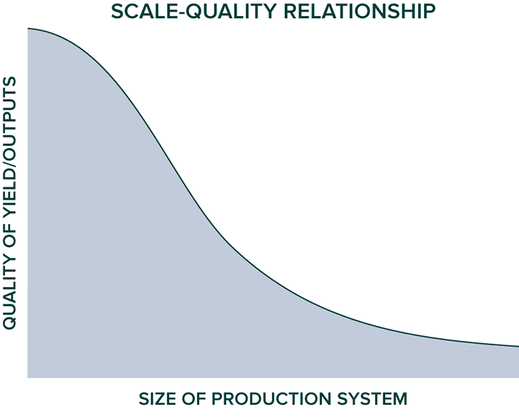
In general the quality of yield is reduced in proportion to the scale of the system in which it is produced.
65. Cheap Tools Are Too Costly
Only high-quality, well-made tools and materials are worthwhile unless the goal is short-term, poorly done work. It’s hard to achieve a higher quality work result than the tools you use; for example, you can’t cut to 1⁄32" if your marking tool is only accurate to 1⁄16" marks. The precision of the tool begets the precision of the result. Buying the highest quality tools you can afford is the only affordable option in the long run, and using them is far more enjoyable anyway. The only tools or design decisions I’ve ever regretted buying or making were those I was trying to save money or time on. Over the long haul—and long haul is the point here—only high-quality tools and materials function well enough and for long enough to be both effective and economical. It’s also important to understand how quickly the quality of tools and materials has deteriorated over the years. In just the past ten years, the quality of basic hardware store items has gone markedly down, let alone the “old steel” put into our parents’ tools, which now can only be found through very high-quality makers that must be sought out. In a day and age when junk with planned obsolescence is the norm, one has to go out of the way (often times far out of the way) to find something actually worth buying.
66. Quality of Work Affects Labor and Management Capacity
The type of work, not simply the amount of it, influences to a large extent the capacity of human beings in the system.
67. Apply Present Resources Now
A great example of this strategy is buying and spreading organic seed now, such as alfalfa, which is currently under GMO research and likely dissemination (if it’s not already in the food supply). This means that future alfalfa carries with it a high likelihood of contamination, even if it’s certified organic. A similar example can be found in many tools—whether an axe, a flashlight, a firearm, or an excavator—they are extraordinarily cheap (relative to their true, past, and likely future costs) today and won’t be forever. In fact, many will likely become relatively unavailable down the road. Fossil fuel is a prime example.
68. Storage Always Runs Out
Stockpiling of energy or materials, while often a valuable strategy, must always be tempered with the need to renew such stores. All physical resources eventually perish, and therefore, renewal is crucial. The balance between storage and renewal is in constant flux and should always be recognized and adjusted for.

Squash harvest at the WSRF—one of our primary storage crops
69. House as Water Tower
The need to store water high in a site such that it can be gravity fed to points of use is fundamental. In a cold climate we must bury this storage below frost, ensure high flow volumes, or store it in a warm space. On most sites without access to a significant spring high on a slope above zone 1 and other areas of the site, using the home itself as a water tower is the most practical solution. This can easily be achieved with a small- to medium-size cistern of plastic or steel positioned in the top floor of a home. (See chapter three for more on this approach.)
70. House as Dehydrator
In cold, humid climates the major harvest period often coincides with cool, wet weather, making drying difficult. Given that dehydrating is a fundamental food storage strategy, we must have multiple methods of drying foods when possible. Using the home itself for such a task is often the most practical approach, since it must have a heat source anyway and should be well ventilated. It is easy to make the home serve dehydration needs with a woodstove, adequate stack effect for ventilation,††† and space for hanging crops to dry.
71. Clarity Points and Leverage Points in Time
Throughout the year there are periods punctuated by intense windows in time when one can see how the systems around them function. These are often during the swing seasons and in times of contrast, such as the first rainstorm after a dry stretch, the first warm day in spring, or the first frost. These periods can come unexpectedly and offer crucial insight opportunities for learning about our places and how to fit within them synergistically. Spontaneous action to able to access the value of these periods is crucial. You must see them coming or quickly note their arrival and be able to drop everything at a moment’s notice to take advantage of these opportunities.
Such instances sometimes entail a long walk at night, getting dirty, lying on the ground in the mud to see something occur, listening carefully in the night and getting out of bed to see the event, and so on. Such events will come, and you need to be ready to listen, see, feel, maybe even taste. Windows of alignment with a place through ever greater realizations about the place are there to utilize if you are open to them and are willing to be uncomfortable or joyfully spontaneous when necessary.
72. Principles Are Only Useful if Actually Followed!
With principles and strategies in mind (I hope you’ve used the above directives to remind yourself of those you have noticed already), we are now ready to move into the next phase of thinking about the place we will be cocreating: a systematic process for decision-making—the pencil-meets-paper step in the design process.
Understanding Your Site and Finding the Synergies
At the outset of the journey down the resiliency and regeneration path, one is often overwhelmed with questions—the unknown simply outweighs the known at this point. A structure for sifting through the seemingly endless variables is needed. Enter a process. Its beauty is its ability to narrow down options; its danger is in missing solutions that may be important. It is important to begin with two foundational elements: (1) you and (2) your place (or intended place). The rest of the design process can flow effectively from these two starting points but only if it is informed by the existing conditions of you and your place. At this point in the design process, you may be looking for a piece of land on which to develop a home or farm, or you may already reside in that place. Either way, the process can be used to bring to the surface your own goals (and those of others living or working on the site) and the characteristics of the land on which you are considering residing on or already do. The design process is successful when it finds synergy between these two variables at work.
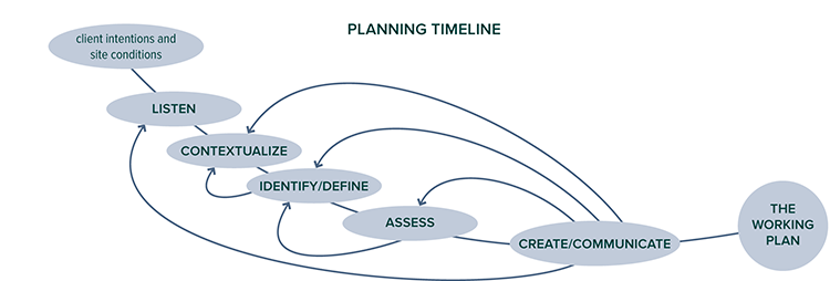
Our planning process transforms the client’s intentions and site conditions into an optimal plan. Without a process rooted in analysis and feedback, quality spaces are not achieved. Illustration courtesy of Whole Systems Design, LLC
“You” means your goals, your skills, your vision, your past, and your intended future. It also means your family, your pets, and your stuff. “Your place” means the physical site—your homestead—on which you live or intend to live. The goal in the beginning of the design process is to find as synergistic a fit between you and your place as possible. Ideally, a place matches your goals before you have arrived at the place, but it doesn’t always happen so neatly. Much of the time people already have a place and must work to understand it, learn what it can do well, and decide how to adapt their own goals to meet their place in synergy.
To successfully develop a durable homestead, farm, or any other land-based endeavor, we must partner with processes that aid, not discourage, us. That means we must be willing to put our own original goals aside and allow our minds to be changed. It is important to detach from expectation; we’re always in a state of adapting ourselves to our places–learning what, truly, our place can manifest most fully, what it can and truly “wants” to do. For example, even if it has always been your dream, you don’t want to build a massive fish-growing infrastructure if you have little water, or plant a large elderberry farm if you’re on droughty soil, or anything else that is misaligned with the place you find yourself. Creating a successful farm or highly productive homestead is hard enough—even if you’re not fighting the natural tendencies of the site.
In our design practice we tend to work with professionals that are relatively successful in their field—they are good at what they do and are used to achieving positive results for their efforts. They buy a piece of land, usually coming to the process with several clear goals of what they’d like to accomplish. They tend to have the goals in hand but the inherent characteristics of the site out of mind. This often leads to problems. It’s not rare that we’ve seen a client attempt projects that are unsuited to the site he happens to live on or has recently acquired. This seems to happen most commonly when people have experienced success at something and attempt to extend that success into a realm in which they have less experience or in which the context (and rules of the game!) have changed.
This reminds me of a quote from Jamshid Gharajedaghi that a good friend often uses to describe such situations—these difficulties being common in the world around us and sometimes quite tragic:
The most stubborn habits which resist change with the greatest tenacity are those which worked well for a space of time and led to the practitioner being rewarded for those behaviors. If you suddenly tell such persons that their recipe for success is no longer viable, their personal experience belies your diagnosis. The road to convincing them is hard. It is the stuff of classic tragedy.
Land plays by its own set of rules, and it can be surprisingly unyielding. Failure on land is much more common than success. Indeed, the history of humans and land is most often a legacy of spectacular failure. Our job as designers of land and human habitat systems must therefore be as ecologists first and foremost—to understand how the land system is and wants to function, before inserting our own human goals and program into the system. We need the land’s tendencies on our side, which is best accomplished by adjusting our goals, rather than the characteristics of the landscape (though that can be done to significant extents as well). That means we must sometimes be willing to put our own original goals aside and allow our minds to be changed in the process of building a land relationship. We must be open to possibilities other than those we originally envisioned, for the genius of a particular place to manifest. Our task is find the best insertion points toward meeting our goals. Ideally, we flex those goals constantly to best meet the site’s abilities, and if we’re fortunate we do not choose a site until we’ve thoroughly assessed the characteristics of various landscapes in which our project could occur.
I came to my landscape thinking I wanted to plant an orchard, grow some vegetables, and perhaps raise some fish. Fortunately, I had little else specifically and clearly in my mind in terms of intentions. In retrospect this was a blessing; I have since come to learn that it is often those with the strongest convictions about their own goals and destiny that are often bound for the biggest struggles and disappointments in land and in life. I am not suggesting that having clear goals is a bad thing. Clarity of goals is key, and the willpower to make the goals a reality is crucial. But unchanging, stubborn effort toward such goals is dangerous when the universe (or a piece of land) is conspiring to help you do something very different.
For example, my first project on the site was to plant a small orchard. In the spring after I moved in, I had identified a very sunny area that seemed good for a grouping of apples and pears, so I walked down one evening and started digging holes. The next morning I went down to begin planting the few trees I had managed to buy thus far for the project. All the holes were filled with water, but curiously, it hadn’t rained. I knew enough at the time, barely, to realize that without major modifications this was not a good site for an orchard. The following year I had saved up enough money to hire an excavator to build a pond—figuring that such a pond would help dry out the field below by catching the water. I was still fixated on that orchard in that location.
By the next year a pond was built and full, but the field below was still just as wet. Only sometime that summer while swimming in the pond did it fully sink in that this area of the site just wanted to be wet, and there was little if anything I could do to change that. It clicked at that moment that I needed to embrace this fact. Small holes filled with water weren’t very useful, but big holes were—I began building more ponds and eventually rice paddies; farming these wetland conditions—not fighting the land’s tendency but working with it.
Embracing what the land we are working with can truly do best is a large part of learning to inhabit a place well—the site assessment and analysis process is aimed at uncovering the basic nature of these land tendencies. The site design process then helps us decide what elements harness the landscape’s tendencies and how to scale, arrange, and manage them. While all landscapes tend toward certain functions more than others, these tendencies are not necessarily innate and can be altered, even to a large extent. I am not suggesting that we do not alter these tendencies significantly in our site development work (in the site establishment phase). However, success in any project is most economical and fastest to achieve if we tap into the existing tendencies in a site rather than change them radically. That said, however, urban areas, especially, are areas in which a radical change in site conditions is often called for.
Goals Identification and Requirements of the Design
To aid in goals articulation, it is important to come up with a list of questions—and it shouldn’t be brief! After all, there’s a lot to hash out, and chances are, your goals are not simple. In my work with Whole Systems Design, we have developed a comprehensive goals-articulation sheet. It is ideal for those at the outset or continuation phase of a project to make such a sheet specific to their own lives and projects.
Once the goals articulation process is in full swing (it’s not something that is ever “completed” by the way) land can begin to be identified for the project using the site assessment tools described on pages 49 and 50. This is also the time when a program can be developed. My work as a resilient designer is not program intensive as is common in most architectural approaches; it is to aim for a more organic process where the program—exact needs of the development in numbers—emerges over a period of time. In most architectural firm approaches program development is primary—the first meetings are all about it. From this program everything else follows suit. In my perspective that leads to dangerous design approaches which we see manifest in the world today—environments that are not appropriate to or taking into account of their contexts, the living places in which they exist. Such a program-first approach puts the human goals at the center of the process not placed as one link in the web that is the place in which the human project will be happening. It is inherently un-ecological. It is for these reasons that the program should usually emerge over the analysis phase, not be set out initially as the set-in-stone goal for everything else to bend around. Often, there are specific program criteria that must be met, however, like a school needing to expand to house x number of new students or a farm needing to graze x number of new acres. These program specifics should always be inspected and evaluated for value, however, in light of the place for the project—often they are inappropriate and countless developments occur each year in which goals are outlined that are completely incompatible with the site chosen.
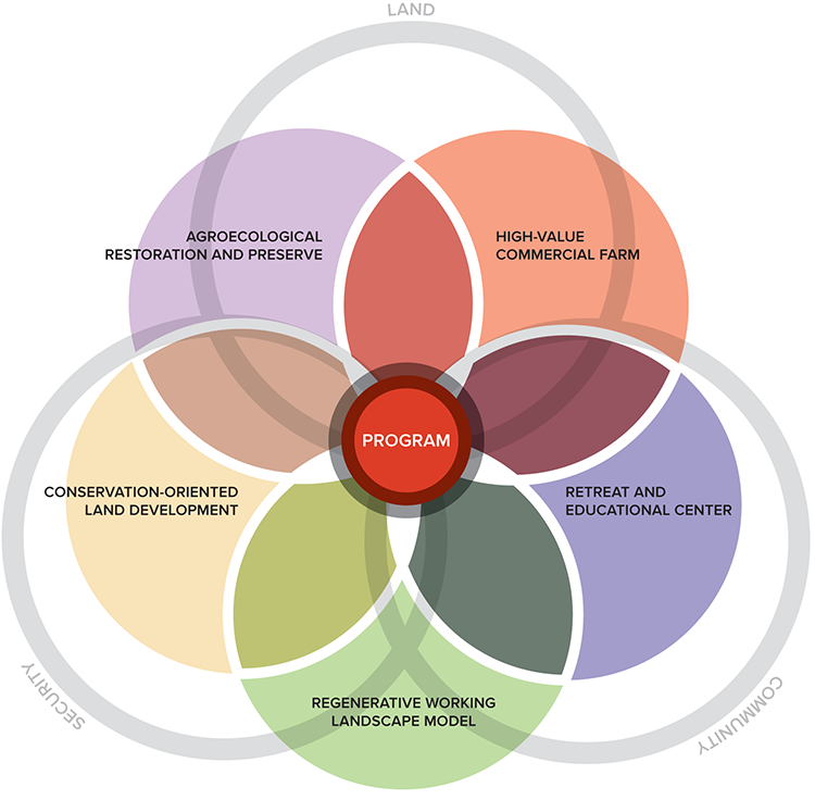
A graphic depiction of a program. The program should emerge out of possibilities recognized during the analysis phase, not imposed onto a site from the outset. Illustration courtesy of Whole Systems Design, LLC
For those already on land they’d like to stay on, I recommend that a detailed site assessment be done initially—before any goals articulation. This “what is” assessment explores the features and processes of the land to identify what it has a high capacity to produce and what it will trend away from, ecologically. Goals and assumptions should be completely on hold in this phase—as we seek only to ask questions, not draw conclusions. This is an incredibly important aspect in any design process—that the assessment phase be unpolluted with judgments and unclouded by an agenda, bias, or any kind of desired outcome. Let the land speak for itself—just listen. For if your own agenda talks more loudly than the characteristics of the land, you will be in for a lifetime of struggle and frustration. Ultimately, the farms and homesteads that truly succeed over the long haul are those on which the land’s innate capacities are being tapped and harnessed, never resisted or forced into something they are not.
Assessing the Site
Site assessment is performed both when one is looking for land and home and when one already resides in a place. This part of the process involves overlaying criteria on prospective properties—or the one you live on—to find good matches with the identified goals. The goals-articulation work performed above is used to generate a list of criteria that is applied to various landscapes of interest for those seeking land. A gradient of criteria is helpful in this process, starting from primary criteria, which are “nonnegotiable,” to secondary, tertiary, and so on, ordered by importance. For example, we often work with people whose primary criteria include all-day sunshine (solar access), two-wheel-drive vehicle access, abundant water, and decent soil; with secondary criteria being walkable to a school and views; with tertiary criteria such as great neighbors and an existing barn. The following criteria are commonly identified in our process with clients as we help guide them toward sites that are most suited to helping them reach their goals.
• Location within area of interest: county, town, neighborhood
• Site access: Length and grade of driveway? Condition of town road?
• Solar access: How many hours of sun?
• Aspect: N-S-E-W facing?
• Size (acres) and shape of parcel
• Elevation change (feet)
• Views: positive and negative, night and day
• Water: Amount of rainfall, streams, seeps, springs, wells, ponds
• Soundscape: road noise, especially
• Soils: Any prime or quality agricultural soils? Inundated soils, restrictive layers, or shallow bedrock?
• Slope: Steep areas?
• Vegetation: Dominant cover type—field, hardwoods, softwoods, maturity, species, values, unusual species?
• Microclimate (within region): Cold pocket? Snow belt? Warm? Dry?
• Privacy
• Schools
• Taxes
• Regulations: setbacks, zoning, and so on
• Mineral resources: quarry, sand, clay
• Overall beauty
Land Analysis
What will nature allow us to do here, what will nature help us to do?
—

Climate analogous regions to the WSRF site. These areas contain the most useful design strategies that we reference in our work. Illustration courtesy of Whole Systems Design, LLC
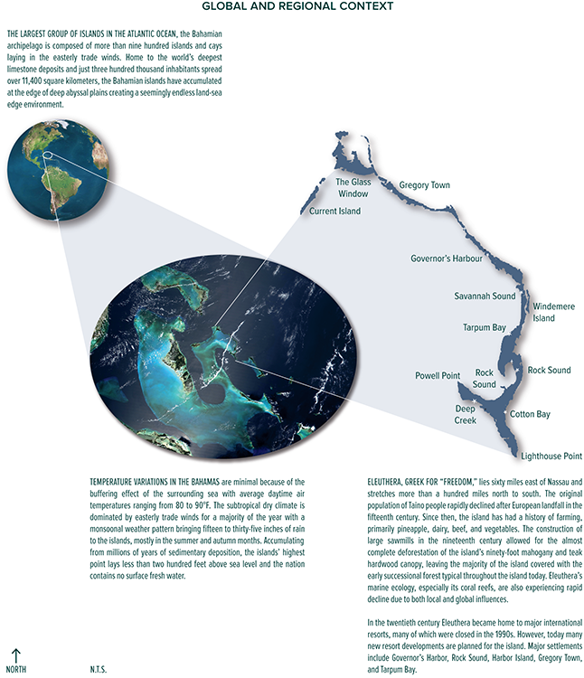
Our process starts by taking a step back, looking at what systems are in play on larger scales than those within the boundaries of our site. At this scale we examine social, cultural, and environmental history, as well as broad climate conditions and land types. Illustration courtesy of Whole Systems Design, LLC
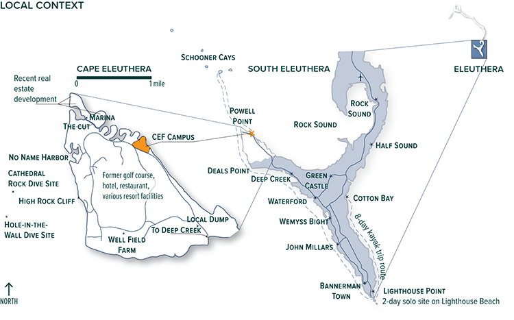
Looking at a closer scale, we again examine social and cultural influences and dig deeper into land and climate conditions, such as plant hardiness zones, natural communities, and historic land-use patterns. Illustration courtesy of Whole Systems Design, LLC
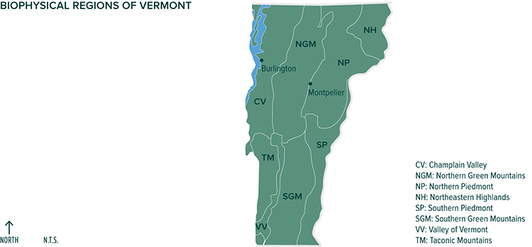
An example of regional design context: Biophysical regions help frame the site’s place within the larger landscape by defining broad regional characteristics, such as plant communities, geologic and physiographic history, animal communities, and climatic attributes. Illustration courtesy of Whole Systems Design, LLC; Source data from Thompson and Sorenson, 2000
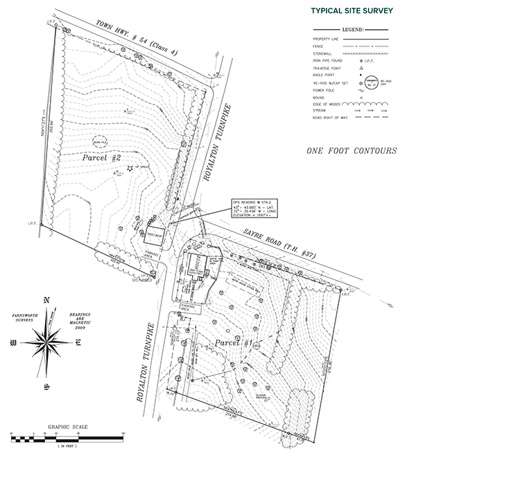
At the site scale we start with a base layer of information that is usually heavily informed by a site survey by a professional civil engineer or surveyor. The survey provides an invaluable level of detailed site information that includes contours, utilities, access, infrastructure, forest cover, and the exact locations of each.
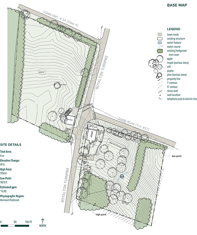
From the survey we distill the most salient site aspects and represent them in ways that are more useful to our design process, provide clarity, and assist in communicating with clients. This is our base layer of site design and planning, the base map. In lieu of a professional survey, there are other ways to create a base layer, such as using handmade surveying tools (for instance, an A-frame level) and triangulating locations using prominent site landmarks. Aerial photos and tax maps can also be helpful in creating this layer. Illustration courtesy of Whole Systems Design, LLC
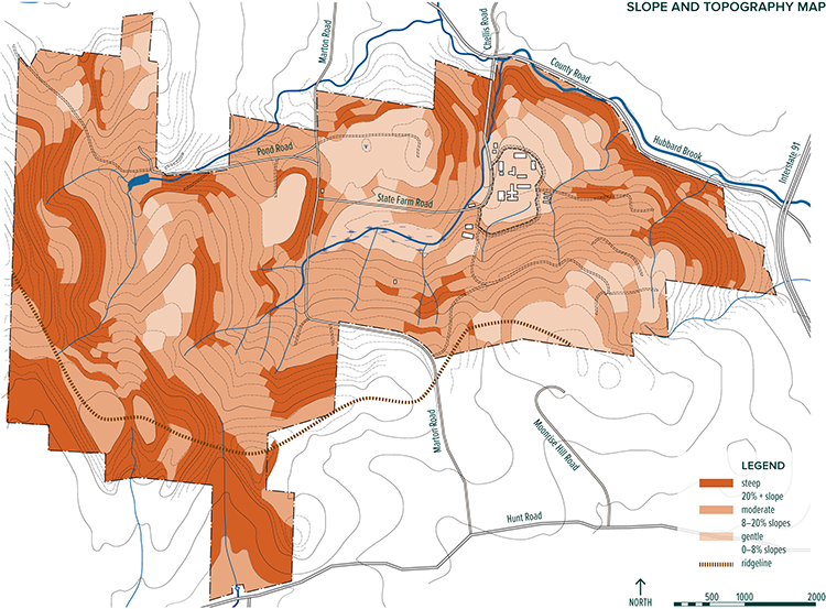
In landform analysis we’re looking at the shape of the land. Using the contour lines available, slopes are classified into different levels of severity and assigned an accompanying color or hatch so it becomes clear, in broad strokes, what areas lend themselves to certain uses. Illustration courtesy of Whole Systems Design, LLC
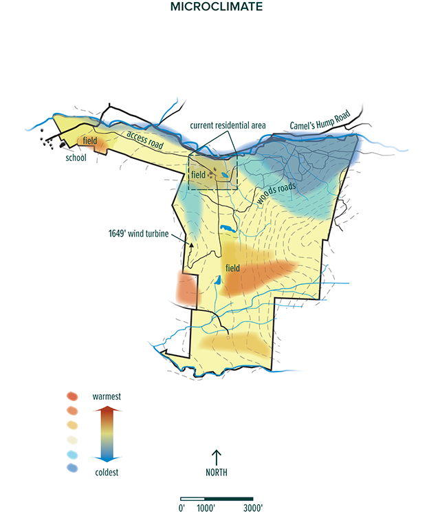

Built elements, vegetative cover, and the direction a slope faces (aspect) compounded by the severity of the slope can often create atypical climatic conditions. These are called microclimates, and mapping them can be helpful in determining placement of new development or cropping systems. We analyze the site on a scale from coldest areas to warmest, identify dominant seasonal wind directions and types, and often look at how air and climate fluctuate over time. Illustrations courtesy of Whole Systems Design, LLC
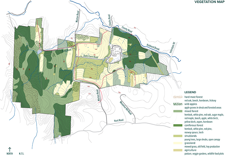
Next the site’s varied existing vegetation patterns are mapped, revealing an understanding of their location, size, and pattern of distribution.
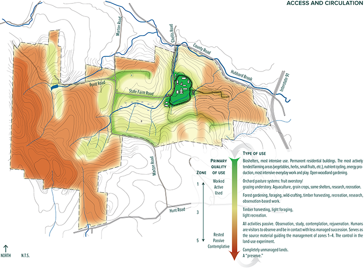
The property is broken down into existing-use zones based on how frequently people utilize an area. Roads and trails are put into categories of primary, secondary, or tertiary so the hierarchy of use is easily identifiable and defined. Illustration courtesy of Whole Systems Design, LLC

There have been soil surveys done by the USGS for every state and region in the United States, and can typically be found online. These surveys classify each different soil type, depending on parent material, depth to bedrock, slope, composition, porosity, and many other criteria, and give a detailed description of each. These reports offer broad-stroke information on the different soil types suitable for a first phase of analysis. Soil samples should be taken and sent for testing before any detailed plans are developed. Illustration courtesy of Whole Systems Design, LLC
Site—land and infrastructure—analysis is performed when land is obtained, or before goals articulation when land is already available for the project. Site analysis involves directed observation and on-paper map drawing of the features and processes of the site and those that influence the site from elsewhere. There’s an important distinction here: Features are what people tend to think of identifying—rock outcrops, soil, water, buildings, trees. But process—phenomena that occur across time—are just as important: wind, sun/shadow, animal movement, people movement, noise, water tables rising and falling, erosion, and so on. Site analysis involves direct observation of as many of these conditions as possible within a reasonable time frame and uses indirect tools such as mapmaking to aid in the process of discovery.
If you are fortunate enough to have a piece of land already with which to utilize your goals, you should be, in part, directed by the site—its characteristics, what it can accommodate well, and what it is not well suited for.
The site analysis process includes assessment of the existing conditions of the features and processes on-site that are of most influence on the design and arranged according to scale. The analyses are not complete until the implications of each assessment are understood—ideally, through implication statements made on each analysis drawing. An example of an implication statement would be, “Because the site is exposed to cold northerly winds, sensitive plantings and heated buildings should be protected from the north.” And “Because the home on-site is listed on the National Historic Register, effort should be made to preserve exceptional aspects of the home should any renovation occur,” and “Because of a seasonally high water table over the northern half of the property, buildings, plantings, and other developments that require well-drained soil conditions should be avoided there unless the condition is modified.”
The phrase “of influence” at the top of the previous paragraph is crucial because you can’t analyze every existing condition. But selecting what not to assess is always a judgment call and is where experience comes into the process—it’s not easy to decide what is of influence, for example, if you’ve only done site analysis a handful of times before, so those not experienced in doing site analysis on multiple projects/landscapes should err on the side of including more features/processes than fewer. Existing conditions here, is the operative term—as future conditions are the design (intending/proposing) phase—analysis is the “what is” phase. Arranging the analysis across scale is important to get a sense of how various factors influence the site from large scale context-level conditions such as bedrock, soils, winds, and even regulations, cultural or legal aspects, and mid-scale site characteristics such as existing vegetation to microsite scale conditions such as gallons of water available per minute in a spring. Such existing conditions include but are not limited to the following.
Context
• Geology and soils
• Climate
• Ecology, forest cover, wildlife
• Legal/social/cultural/economic
Site Scale
• Slope and topography
• Aspect
• Microclimate
• Soils
• Vegetation
• Wildlife
• Views
• Water/hydrology
• Access and circulation
• Infrastructure
• Soundscape
• Historical and exceptional features
Design Criteria
The first part of this phase in the design process involves goal statements, which integrate both the goals ID and the site analysis—these can be called “design criteria.” These statements serve as design guides—patterns that help massage solutions into alignment. They leverage the information gained during the site analysis and goals ID phase to form specific guiding statements that the next design phases can be derived from. Then when design directions do emerge onto paper or into words, they can be checked against these criteria to ensure that they make the most sense possible and fit within the parameters and patterns of both the client’s goals and the site’s character. We like to organize design criteria/goal statements according to aspect of the design so they can be most easily referenced later on. An example for one project—a large commercially oriented farm with an educational and research component—goes as follows:
Vegetation
• Provide wind protection from the predominant cold or damaging wind directions.
• Be diverse and proven for multiple yields, including foods, medicines, habitat, biomass and fertility, thermal value, interest, and so on.
• Be established in patches and clusters, not homogeneously, and prioritize dynamic accumulators early on.
• Be self-maintainable wherever possible; for example, groups of cross-pollinating species, guilds for pest prevention, and fertility building.
Infrastructure
• Capture, process, store, and distribute electricity and heat.
• Process farm products.
• Process nutrients generated within.
• Offer a diversity of microclimates in the landscape, and shelter outdoor spaces from wind, rain, snow, sun.
• Be composed of native materials.
• Be wheelchair accessible.
• Have the best possible indoor air quality.
• Be composed of and driven by biological systems as much as possible; for instance, living roofs, interior plantscaping, greywater gardens.
• Optimize views of the surrounding landscape, and promote direct sensory experience of the living world as much as possible.
Social Spaces (Residence, Circulation, Gathering)
• Create work centers
• Accommodate a range of inhabitants. These include guests staying a few hours or a few weeks and permanent residents.
• Offer a gradient of openness across the landscape, ranging from open pasture spaces and knoll-top lookouts to inward-facing gathering spaces within intensive gardens.
• Closely connect zones of intense use.
• Reduce energy expenditure in maintenance.
• Promote contact with living systems wherever possible.
• Offer outdoor use across the day and seasons.
• Provide a strong public-private gradient.
• Be legible in its design and construction, and help build awareness in the inhabitant.
• Encourage visitor interaction with gardening and farming systems.
• Be wheelchair accessible in certain areas.
• Preserve and highlight the site’s land-use history.
Such design criteria can be thought of as quality control points and reminders in the design process. Have fun developing them, and try to appreciate them for the service they can provide, almost like checking your math in an equation. Criteria let us look back into the process to be sure some big amazing creative idea is not leading us away from actualizing a basic requirement of the design.
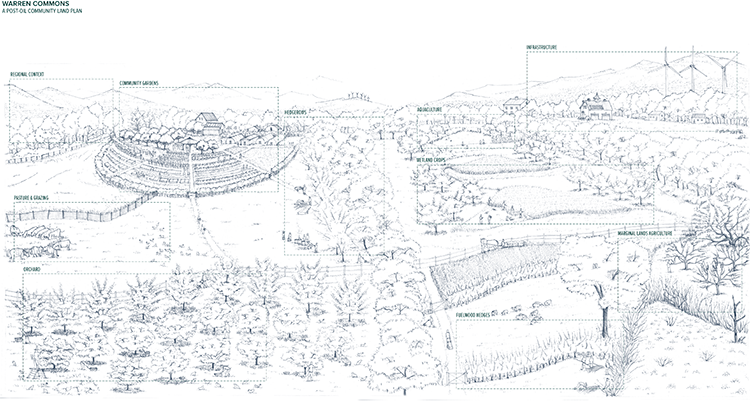
Clearly articulating the possibilities: a bird’s-eye view of a fully developed master plan Illustration courtesy of Whole Systems Design, LLC
Imagination: Limiting Factor to Design
With the previous assessment and initial guiding work underway, the fun can begin. This is the time to pull out the pencils and tracing paper or drawing pad and start sketching the possibilities for a space, an object, or a system. This is the time to think through the project in the horizontal and vertical planes and across time. During this process it is crucial to immerse yourself wholly in the project’s possibilities.
About six years ago my colleagues and I were hired to plan a large new innovative farm development called Teal Farm in Huntington, Vermont. The objective was to design and implement a site that would model food systems truly fit for an adverse climate changed future with emerging resource constraints, human health, and toxicity challenges. It was crucial to reference historical patterns in such a job and to imagine carefully what future scenarios could actually be, to even begin to think about how to respond to them—and a good design needed to be that response. In this light we can see that design is articulating a response to conditions that might be—but may not be yet; we must plan as if.
To see what “as if” might actually involve, we need to immerse in the possible futures of a place and project in that place; we need to act it out, be inside of it, live it to the extent possible. If design is the process by which we anticipate and respond to changing conditions over time, it is fundamentally a phenomenological activity. Amid the year long initial master planning process I spent a handful of weeks immersed in a particularly deep way during the Teal Farm process. This experience was probably a lot like that of an actor who takes on their character in daily life to most fully get to know that person, their story, and how to communicate it. Conversations over dinner revolved around harvesting chestnuts in the understory of a two-hundred-foot-tall anthropogenic forest canopy. My friends on the design team spoke in detail about the stone barns our children would be playing in and what they would do with the pine nuts from the trees their great-grandparents had planted. We talked about what it would be like when you planted in garden soil that you could stick your whole arm into with ease. We lived in this future world, intentionally ignorning the current state of affairs in order to be able to clearly envision other possibilities—higher possibilities. It helps to be single, to live alone and/or have other conditions that do not break this attention to the new reality which you are imagining. It requires unbroken attention and perhaps a certain obsession to get deep into a design. I found that the real breakthroughs came 8 to 16 hours into a work day and not usually inside around the drafting table but out skiing, walking, or climbing a nearby mountain.
At some point weeks into this design process, I ran into someone I knew in town, and he was surprised to see me; it had been a while. “Where have you been?” he said. “Haven’t seen you as much as usual.” I’d been around, not away, so it was strange he said this. But of course, I’d been spending a lot of time in Huntington, Vermont, in the year 2250. Our design for the Teal Farm could not have been possible without this mental time travel, and I would go so far as to say that any good design for other places involves such an approach during parts of the process. I think one of the primary reasons why most design around us today is so shallow is that it is too often born of someone doing it for a living, not as a calling, an obsession, something they actually love to do each day. The necessity of deep imaginative immersion here seems to apply to the creation of everything—be it a landscape, a business, or a lifetsyle. Often, the results one seeks do not happen simply because the process required to activate them is not nearly as deep as is necessary. Design in this way is not a “day job.”
The concepting phase is the time to immerse in this way, though at all phases of the design after the assessment phase, it is important to think “from within the design”—from within the place-to-be. This is rarely done enough, and I can honestly say that we do not do this as much as would be ideal in most projects—it takes a lot of time. Fortunately for the owner-builders, they can take this imagining time sitting on a rock in the garden, strolling the land, and in various other passive ways of hanging out on-site. For the professional designer this imagining time is highly limited for practical reasons—especially if they have a family or a “normal” life with a routine schedule. We still devote unbroken stints of obsession/immersion to projects but having an increasing family aspect to life limits it. We always encourage the client to spend time this way, as the possibilities for immersion are greatest for those living on site. They can then share the visions they have with their assisting designer—their site facilitator.
Schematic Design: Sorting Through Multiple Development Options
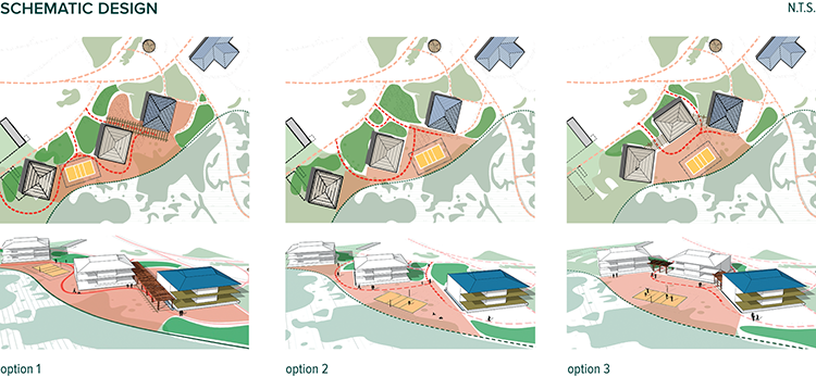
Different approaches explored during the schematic design phase lead to a working plan that highlights one of the options given or may combine the best elements of all three. These schematics were performed for a faculty housing addition to a school campus. Illustration courtesy of Whole Systems Design, LLC
Once the process of goal clarification has begun, the site’s context and characteristics have been explored significantly, and design-directing statements (design criteria) have been made, actual physical design plans can begin to be developed. The schematic design phase is what many think of when they hear the word “design,” but as you can already see, it only represents a part of the entire process and is only as good as the analyses phases preceding it. In schematic design the designer puts to paper various versions of what seem to be the best solutions to the challenges thus far identified (new challenges will be identified in this process, so be on the lookout for them!).
The schematic design phase is the “take the best, leave the rest” part of the design process, where all sensible possibilities—drawn from the implications of the analysis and design criteria—are considered, mapped, studied, and tweaked. Schematic design is most often performed via plan-view drawings, sometimes accompanied by cross sections. Building schematics should be heavy on cross-sectional views, while landscape layout schematics would most sensibly be generally weighted toward plan views.
We have at times, when the budget allowed, performed 3-D perspective schematics, which are incredibly useful in helping think through the possibilities for space. Perspectives, even with computer-aided approaches, can often be time consuming and expensive. It is important to point out, however, that thinking in 3-D is crucial to developing a space in the most sensible ways. The old adage, “If you can’t draw it, you can’t build it,” carries a ton of weight in the construct-ability of an object or space, but I would add another: “If you can’t sketch it in 3-D, you can’t think it and you can’t think about it clearly.”
And if you can’t think about it clearly, it won’t be a very high-quality space—you find that out later when you inhabit places that aren’t well thought through, with countless second-guessing: “Why didn’t we put a switch here, steps there, a wall here, or a water hydrant there?” Anyone that would like to think through objects, spaces, and, indeed, places clearly should become fundamentally literate in drawing such that she can sketch with relative ease buildings and landscapes in perspective, cross section, and plan view. It’s not that hard with some practice.
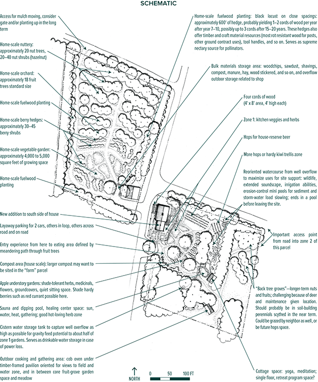
A schematic plan depicts how the different concepts will take physical form on the landscape. Illustration courtesy of Whole Systems Design, LLC
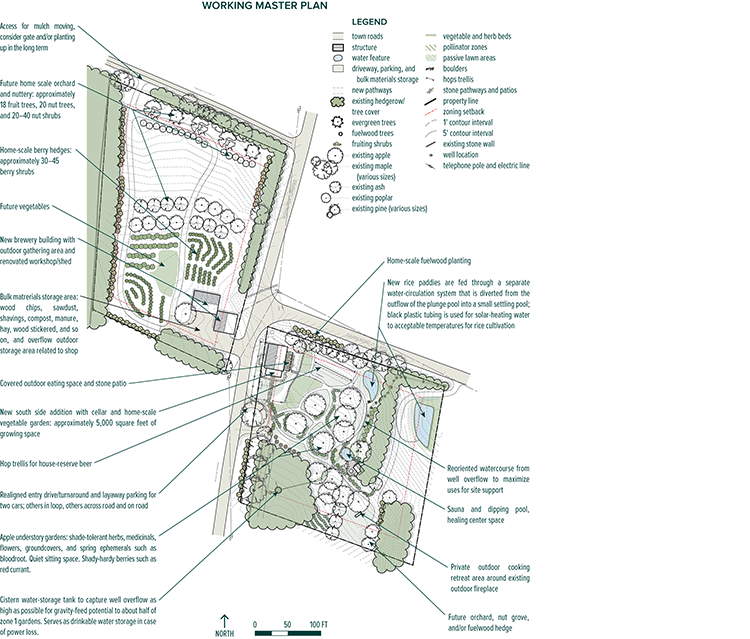
The schematic plan is then refined and developed into a working master plan that will help guide development. Illustration courtesy of Whole Systems Design, LLC
Drawing also has been shown to activate parts of the brain that are otherwise underutilized—those parts of the brain are likely crucial to wholly thinking about how to solve problems systemically and effectively in a place. Drawing is baseline empowerment in this regard. While drawing techniques are out of the scope of this book, I have highlighted several tips on developing visuals to aid your design that are particularly useful to the nonprofessional designer but earnest homesteader-farmer (and therefore designer by default!).
1. Basic materials to have on hand: rolls of tracing paper—12" and 24" by 50 yards; pens and mechanical pencils—0.7mm HB is the most versatile; an architects’ and engineers’ scale (ruler); graph paper with ¼" grids; colored markers; a triangle or two, and a circle template. That’s it—you don’t need to spend much money on drawing supplies to do massive amounts of design. If you’d like to supplement your work digitally, I’d recommend learning Sketchup and Adobe Illustrator—both are accessible and can be self-taught by those who are computer inclined.
2. Trace maps, plans, and drawings you can find of things you like. Don’t be bashful—cut out visuals from magazines, books, and other sources, and trace them. This gives you the feel of making plans, engenders patterns in plans, and starts to lend some fluency between the hand and the visual result, loosening one’s creativity up a bit.
3. Just draw. The biggest reason that few homesteaders and farmers draw up enough graphic plans of their developments seems to stem from the simple discomfort associated with producing graphic work. While most of us grow up learning how to communicate basic ideas via words, few of us receive any real training in conveying equally basic ideas in graphic form. This is actually a tragedy for society because it severely retards the creative potential of citizens at large. Drawing and being able to take a decent photograph is as important to imagining, conveying, and creating functional places as writing a decent paragraph about the place—probably a lot more, actually. So please, do yourself and society a favor—loosen up and start drawing!
4. Photograph, print, and trace over: Take an image of a space you would like to develop, print it, then trace over this photograph using lines to show the new changes on top of the existing scene. This is an immensely helpful way of teaching yourself how to draw in perspective. You can also project the image on a wall if you have a projector and use markers on tracing paper against the wall to do the same at larger scale. This works great for really getting into the possibilities of a larger site area. If you don’t have tracing paper, you can stick paper onto a window and turn normal bond paper into tracing paper. A glass coffee table with a light underneath works even better (what designers call a “light table”).
5. Mock it up: There’s absolutely no better way to physically hint at and offer insight into the possible changes (and results) to a place than using large objects to lay out in a space for help in envisioning the changes. We use wood, tires, vehicles, people, barrels, potted plants, rope, chalk lines on the ground, and much more to do this. Mocking up a design is not always possible at larger scales, but for smaller spaces it is a fantastic tool.
Design for Climate Change
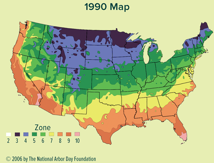
The USDA plant hardiness zone maps for 1990 and 2006—a clear indicator of the need to plan for change.
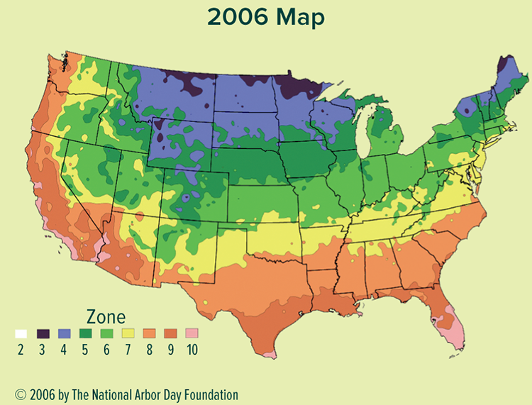
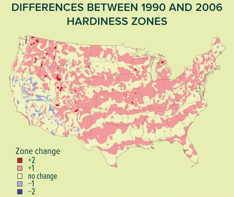
A majority of the changes from 1990 to 2006 indicate a clear rise in average temperatures across the country.
Adapting Land to Rapid Change
Neither predominant agricultural models nor most housing and transportation systems are designed to withstand significant climate changes or resource supply changes. These systems currently depend on a constant and unbroken source of cheap energy and materials (read fertilizer, pesticides, shipment, parts, heat, electricity, and fuel) to operate. They also depend on the climate’s remaining largely the same as it has been for hundreds of years—the Midwest corn crop won’t be harvested without both reliable and cheap energy and plentiful rainfall. Many homes and apartments (especially tall buildings) in the northern one-third of the country are not habitable in heat waves when the electric grid is down. Landscape-level developments that intentionally adapt to these changes employ the following components, among others:
• Microclimate development, including windbreaks, snow-retaining hedgerows, thermal mass via water and stone, and sun-trapping vegetated or built arcs. These systems provide a buffer against regional climatic stresses by localizing climate at the site level.
• High biodiversity of crop species and crop systems, utilizing neighboring warmer and colder climate zone diversity (USDA hardiness zones +/– 2 zones) and the intelligence of complex ecosystems. Reviving the genetic diversity lost in the wake of global industrial agriculture is a prerequisite for adapting to rapid change. Since current challenges are so severe—from climate changes to persistent biospheric contamination—we will likely need to not only revive past levels of diversity and health but evolve greater, unprecedented levels of biodiversity and ecological connectivity.
Microclimate Development
A microclimate is any discrete area within a larger area of differing climate. Microclimates exist unintentionally in nature, but good design creates microclimates intentionally. Since cold is a limiting factor (along with light) in sustainably inhabiting the New England landscape, developing warm, protected microclimates is the top priority here. Cooling strategies, however, will likely become increasingly important, especially in southern New England, if conditions continue to warm. Optimized microclimates result in the following:
• Lower active energy needs for buildings (less fuel, less cost, less pollution). Example: passive solar house within a passive solar landscape.
• Longer growing seasons relative to the surrounding environment. Example: climate-designed garden spaces that stay frost-free for weeks longer in the spring and especially in fall than adjacent areas.
• Higher yields from plants and animals, via better growing conditions. Examples: warmer environment for heat-loving crops; cool-shaded spaces for domestic animals in the hot summer; wind-sheltered spaces for plants, animals, and buildings.
• More enjoyable, lower stress, and healthier human habitats. Longer outdoor living season; more fresh air; more contact with water, plants, living systems; and greater physical activity and mental stimulation. Example: outdoor living spaces comfortable in the summer, warm in the winter.
It is relatively easy to adjust the climate of the spaces we inhabit, whether they be horticultural or for human enjoyment, and the results are stunning. Fortunately good examples of microclimate design abound in the living world around us and in vernacular design, from beehives to termite mounds, to deer wintering areas, to traditional farm layouts and building configurations. It’s only in the most recent era of cheap energy that humans have been able to forget about harnessing innate patterns in the local climate to our advantage.
Microclimate Development Strategies
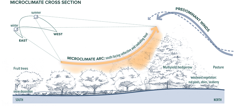
Larger and hardier tree species are placed to the north of high-value zones to both shield prevailing cold winds and create a south-facing space that holds and disseminates heat. Illustration courtesy of Whole Systems Design, LLC
The first step in crafting beneficial microclimates is proper site selection, as some landscape features cannot be changed at all or only to a small extent. The second step in localizing your climate is site design. Once a site has been chosen and a handful of strategies planned for and implemented carefully, you can optimize the existing climate of the site to more fully meet the needs of its inhabitants. Examples of microclimate-creating features are hills, fields, trees, cliffs/stone, gullies, ridges, groundwater, ponds, lakes, roads, walls, lawns, roofs, and courtyards. Employing such features in the development of climate-protected spaces is more effective than attempting to create new microclimates from scratch.
Diversity and Connectivity
Of primary importance for increased food security and regional resilience is developing diverse and interconnected food-crop systems. The following strategies highlight the benefits of high-biodiversity, polycultural food systems.
Many Crops
Early and late frosts; intensifying drought, heat and cold; and other stresses select against certain crops. A broad range of species with different flowering cues and hardiness capabilities is insurance against poor fruit sets, pollination failure, and other problems due to capricious weather. Such an approach is exemplified in a planting scheme that includes apples and plums (early flowering) with elderberries or kiwi (very late flowering)—one of these flowering periods is likely to be okay each year but possibly not both. A wide array of dry and wet-hardy crops is a hedge against a season of drought or inundation. We mix pears on quince rootstock with pears on pear rootstock and plant the same tree in both dry (high) and wet (low) situations in the landscape to hedge against the possibilities of drought or inundation in each growing season; it’s often one or the other, after all. Intentional genetic diversity in species and variety is fundamental to any resilient ecological system.
New Crops
Developing innovative new crossbreeds also helps to ensure resiliency of food systems. For example, crossing a sweet cherry (Prunus avium) with a Nanking cherry (Prunus tomentosa) can create a next-generation cross that flowers like the Nanking (late, thus avoiding the killing late-spring frosts) but has the larger, sweeter, and more marketable cherry. Hybrid vigor is crucial to develop across plant and animal families. Adapting our food system to ever-changing conditions entails continually increasing the fitness of each component in the system, from human to plant to animal. That is good breeding. Breeding never ends but continually adjusts to fit changing conditions with each successive generation.
Warmer and Colder Hardy Crops
Rapid warming and cooling trends will probably outpace the agility of current agricultural systems. Durable farming systems should be designed to adapt to changes of 10 to 15ºF warmer or colder within the span of a few decades. This is possible to achieve through highly diverse crops, highly connected agricultural-ecosystems, microclimate buffering, keylining, mycelium webs, and other biological resiliency strategies but also by developing crops that can extend into warmer or colder temperatures. If zone 4 became just 10 to 15 degrees warmer (an average low of –10°F), a diversity of bamboos and palms could be grown. Some apples can withstand –50°F or colder—a real plus if the global ocean conveyor belt stops or changes direction.
Evolution as Adaptation to, not Controller of, Change
The question is not if or how much things are changing; changes in Earth’s climate, in human society, and in every other planetary system are guaranteed by the full faith and backing of the Milky Way Galaxy. The question is whether or not we will view such changes as an adaptive challenge—as a challenge to cultivate biodiversity, ecological resilience, and an increasing, not dulling, sensitivity to the possibilities around us. What if our task was fitness within, not attempted control of, the ever-changing conditions of our existence?
Working Plans and Implementation Documents

A student in our permaculture design course working on a design

A detailed drawing of a proposed grading and hydrological system that takes the working master plan a step further. These plans are used to estimate materials and cost, think through the system in greater detail to identify challenges, and as a reference throughout the building process. Illustration courtesy of Whole Systems Design, LLC
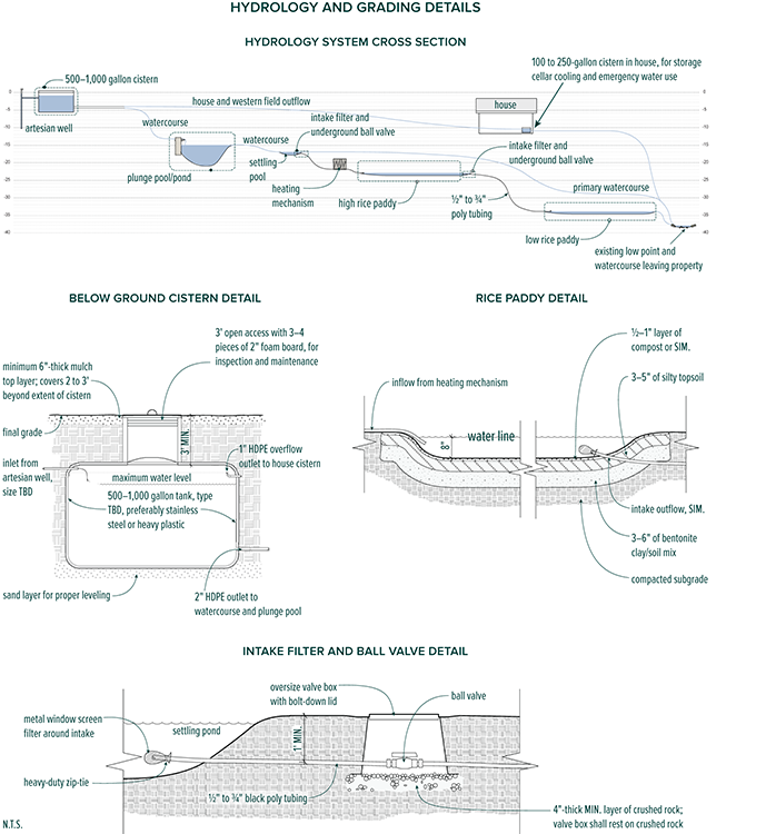
Cross-section and other detailed drawings accompany the implementation plan to give detailed information about specific features and design direction. Illustration courtesy of Whole Systems Design, LLC
Once you’ve worked out various scenarios for developments, it is time to develop a plan of action. These are your plans for development and implementation and range from overall plans for the site over a span of time—a “master plan”—to specific drawings and documents that detail how to actually build, plant, install, or otherwise make the components of the development—the construction or implementation documents. These plans and textual specifications are often drawn to scale and include both plan view and cross-sectional drawings. Master plans are not solid, set-in-stone documents—although everyone wants them to be. Heck, I am hired many times largely because people want a plan that’s solid, unwavering, and something they can follow now and in ten years. Sorry—they don’t exist. Most plans are iterative. And despite the authoritative sounding name, master plans are no exception. A good “master” plan is a “working” plan—in other words, it’s the latest version of good approaches. It will change; that much is guaranteed. The important part to remember is that it’s a guide for next decisions, not an ultimate life map or site oracle. Land and the lives unfolding for them are far too complex, unpredictable, and mysterious for any vision of a “way” to hold up year after year.
And they have one more primary purpose: to avoid huge mistakes—for instance, not putting the house in the wrong place or putting the orchard where a road for the eventual barn will need to go. Such plans are “master” only in that they locate elements that are thought to be inevitable in locations such that other actions can be made down the line. The paralysis that dominates a place when such a plan doesn’t exist or, conversely, the repeated mistakes made when such a plan is not in effect are spectacular. In this way a master or “working” plan is essential. But don’t abuse it—remember, it’s a living document. It must change to remain valid.

Portions of the implementation plans are detailed enough to warrant a more thorough level of documentation. Features such as ponds and small outbuildings are often high-priority and costly items that require a more in-depth study so that expensive mistakes are avoided. Illustration courtesy of Whole Systems Design, LLC
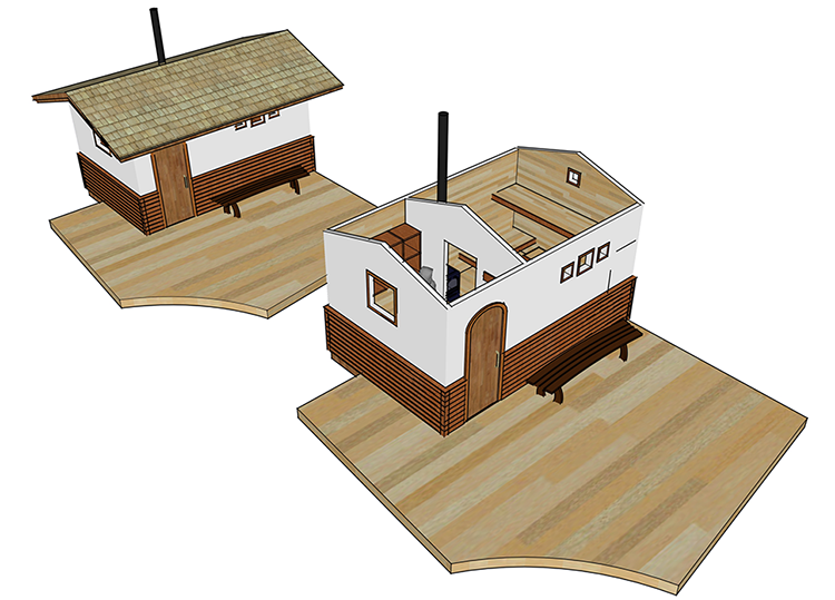
A three-dimensional model facilitates better communication and understanding between designer, client, and builder. The detailed model increases both the efficiency of the construction process and the quality of the end product. Illustration courtesy of Whole Systems Design, LLC
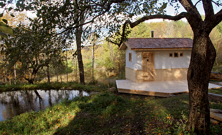
A wood-fired sauna and sunning deck with dipping pool built by Whole Systems Design, LLC, set in an outdoor room within an old apple grove. The dipping pool captures an artesian well overflow that was formerly running immediately off-site into a road ditch. Photograph courtesy of Whole Systems Design, LLC
§§ The concept of ecoliteracy can most directly be traced first to Fritjof Capra’s work of the same title but is now a widely used term.
¶¶ “When I thought about steering the course of the ‘Spaceship Earth’ and all of humanity, I saw most people trying to turn the boat by pushing the bow around.I saw that by being all the way at the tail of the ship, by just kicking my foot to one side or the other, I could create the ‘low pressure’ which would turn the whole ship. If ever someone wanted to write my epitaph, I would want it to say ‘Call me Trimtab.’”
*** Avoiding leaves from oft-used roads is key to reducing collection of benzene and other toxins. When collecting bagged leaves in a local town, we avoid yards with Norway maples or black walnuts in them—those trees produce leaves with toxic compounds We also avoid manure from farms whose practices we don’t know and trust to preclude pharmaceuticals in the material.
††† Stack effect is the passive flow of air or water (or any other fluid) from warm to cold and low to high in a space; also called a convection loop.