
70. Thompson Creek Campground
Map S (p. 361)
| Duration | one hour |
| Distance | 2.6 km |
| Level of Difficulty | some short, steep sprints |
| Maximum Elevation | 1400 m |
| Elevation Gain | 30 m |
| Maps | 83 C/2 Cline River |
Access: Park your vehicle at the day use picnic area, opposite the registration hut at the Thompson Creek campground, located 80 km south of Nordegg and 3 km north of the Banff National Park boundary, on Highway 11.
0.0 kmtrailhead
0.1 kmThompson Creek
0.2 kmjunction
0.4 kmdumpster
1.0 kmjunction
1.3 kmviewpoint
2.6 kmtrailhead
Campers created and continue to use this hiking path that leads up a low hill above the overflow camping area located across Thompson Creek from the main campground. Beautiful views of snowcaps to the west and north greet you before you climb over to another ridge for an equally inspiring view of the North Saskatchewan River.
From the trailhead, walk north along the campground road to the intersection with the road leading to the overflow camping area. Turn left onto this road. Within a short distance you cross Thompson Creek. The creek was named after either David Thompson, a fur trader and map-maker with the North West Company, or Charles S. Thompson, a member of the Appalachian Mountain Club who was in the area during approximately 1900. Cross the bridge and continue along the road to a T-junction where there are washrooms and a water pump. Vehicular traffic must bear to the right along the campground road. To get to the trail more quickly, go left and walk against the campground traffic as far as a dumpster before campsite no. 47. Behind the dumpster, there is a distinct trail that leads up the ridge in front of you. It’s a short but steep sprint to the top. Look behind to the north for marvellous views of the lower slopes of Mount Cline.
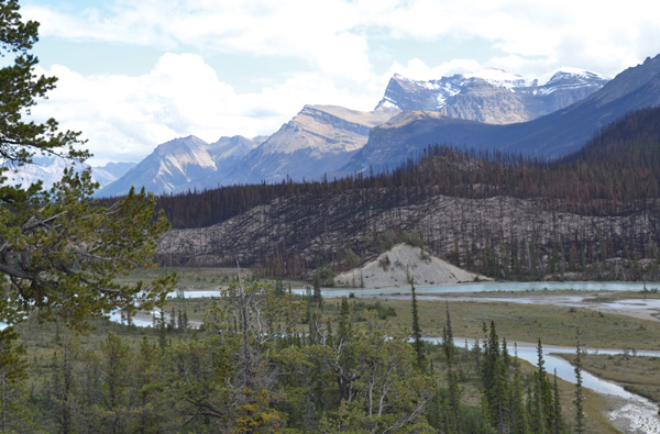
Snowcaps rise above the river terrace burned in the Spreading Creek fire, 2014.
Follow the trail as it swings around the shoulder of the ridge, descends and then climbs another ridge. On the first ridge, there is a plaque dedicated to Karen McKnight, who died in 2010. There are many braids in the trail near the top of the second ridge. Look carefully and bear a sharp right on the first trail that leads downhill. At the bottom of the slope, the trail enters the cool pine and spruce forest, a relief on a hot day. The trail leads to a low ridge overlooking the North Saskatchewan River.
Here you can look up and down the river valley with its blackened trees, a result of a lightning strike during a hot, dry spell in the summer of 2014. This wildfire, known as the Spreading Creek fire, consumed some 12,000 hectares of timber, most of it in this valley. As in the case of many wildfires, the Spreading Creek fire was allowed to burn, and fire crews were called upon only to save the Thompson Creek campground and the warden station in Banff National Park. Nevertheless, fire crews monitored the fire for hot spots near Highway 11 and the Icefields Parkway until the autumn.
Find several upright logs that mark the trail back through the woods to your trailhead.