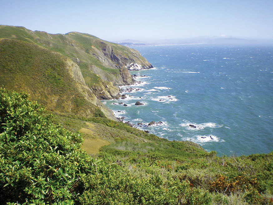
View of the Marin Coast from the Coastal Trail
THE MARIN COAST
Marin Headlands to Point Reyes
The tradesman, the attorney comes out of the din and craft of the street and sees the sky, the woods, and is a man again.
—RALPH WALDO EMERSON, “Nature”
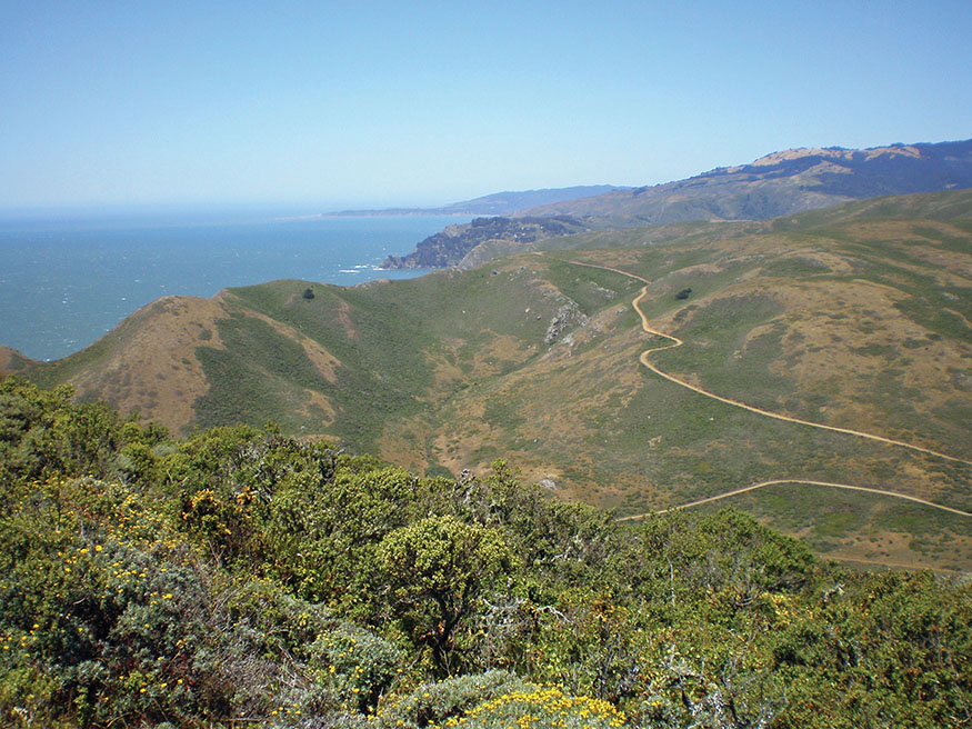
View of the Marin Coast from the Coastal Trail
Why not walk in the direction of life, enjoying peace in each moment with every step? There is no need to struggle. Enjoy each step. We have already arrived.
—THICH NHAT HANH, The Long Road Turns to Joy: A Guide to Walking Meditation
THIS MODERATE 41.3-MILE HIKE along some of the most beautiful and dramatic coastline in the world starts in the Marin Headlands, a short distance from San Francisco, and ends at Point Reyes National Seashore. The first two days of hiking are easy strolls. The second two are longer with some elevation gain, but still moderate hikes. Along the way, the trail passes through three coastal villages: Muir Beach, Stinson Beach, and Bolinas, each offering interesting places to stay and great dining. Take an extra day or two to relax, explore the beach, and maybe even get a massage. A second, shorter walkabout (see page 24) can be done in a weekend. Walk the trails of the Coast Miwok and a stretch of California’s wild and beautiful coast right at the doorstep of the San Francisco Bay Area.
ITINERARY
Day 1: Marin Headlands to Muir Beach
MIST HOVERS ABOVE THE CALM WATERS of Rodeo Lagoon as the morning sun breaks through the fog. The graceful, winding Miwok Trail climbs through the coastal hills up the western slope of Gerbode Valley past the remains of the Silva dairy ranch, home of Portuguese settlers who worked this land in the 1800s. A broken stone wall, a grove of towering eucalyptus, and perhaps the calla lilies that thrive in the Headlands’ marshy lowlands are all that remains of the ranch. As you round the first bend, the sounds of civilization fade, replaced by the trilling of a meadowlark, the high-pitched cry of a red-tailed hawk gliding on an updraft, and the gentle splashing of an unnamed creek hidden from sight in the thick willows.
This journey explores some of the most beautiful country in California, along the hills and valleys of America’s western edge. It starts in the Marin Headlands at a trailhead that’s a short 10-minute drive from the first freeway exit north of the Golden Gate Bridge. Part of Golden Gate National Recreation Area, the Marin Headlands was once a Nike missile site with nuclear warheads ready to defend against enemy bombers, and now it is hundreds of acres of wild coastal hills and Pacific coastline waiting to be explored.
The first day’s hike, a 7-mile stroll to Muir Beach, can be savored at a leisurely pace. No need to hurry. You have all day with nothing to do but walk. At the end of the day, a lovely inn and hearty meal await you.
It was early June when I set out, the start of summer, California’s dry season. The hills were turning from green to brown, but stands of yellow monkeyflowers and white hemlock still filled the washes. Gardens of 6-foot-high purple foxgloves and ranging violet peas thrived in moist, protected pockets.
From the ridge, the view is exhilarating: To the south the San Francisco skyline stretches beyond the Golden Gate, and the vast blue Pacific meets the horizon to the west. To the north Mount Tamalpais rises from the ocean to 2,571 feet, and in the distance, your destination, Point Reyes. Breathe deeply of the Pacific’s wind. In the coming days this sweet breeze will fill your lungs and refresh every cell down to your marrow.
Take the Wolf Ridge Trail to the Coastal Trail, and drop steeply into the Tennessee Valley. The valley’s trail leads to the beach. Waves crash on the rocks and cliffs that form the small, protected Tennessee Cove. It was once called Indian Cove, but its name changed on the foggy night of March 5, 1853, when the SS Tennessee made the final leg of its journey from Panama to San Francisco. Captain Mellus felt confident of his position as he worked the ship toward the treacherous entrance of the Golden Gate, but a thick fog engulfed the vessel, and a strong current swept her past the Gate. Around 9 p.m. a steerage passenger standing on the bow spotted breakers ahead and shouted to the wheelhouse. Captain Mellus heard the crashing of waves. The fog lifted briefly, but it was too late. The ship struck the rocks of Indian Cove.
The crew sprang into action. Chief Mate Dowling jumped overboard with a small line tied around his waist. He struggled to shore and pulled a larger cable after him. All night cable or quarter boats ferried the 551 passengers safely to shore without losing a single life, but the SS Tennessee broke up by midday and sank. Some people say that even today a severe storm will expose parts of the ship still wedged among the rocks.
Looking north from Wolf Ridge
Heading north, the Coastal Trail winds 3 miles to Muir Beach, up and down the bluffs above waves crashing on ragged cliffs. Muir Beach is formed by Redwood Creek, which flows down Mount Tam, through Muir Woods, and into the crescent bay. Houses perch on the bluffs above the beach’s north end. A rocky outcropping divides the long southern section from the smaller north beach, which can be reached at low tide; it’s a favorite spot on sunny days for nude sunbathers.
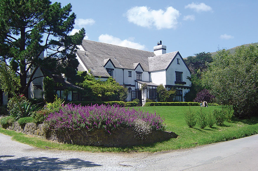
At the entrance road to the state beach stands Pelican Inn, a 16th-century-style English country public house nestled in a wooded valley along Redwood Creek. Only a short drive from San Francisco, it has the feel of a faraway place and time. I settled into a spacious room, furnished with a high canopied bed and Persian rugs, the walls adorned with bawdy prints of 16th-century celebrants at horse races and drunken revelers chasing barmaids.
The Pelican’s pub welcomes locals and travelers on CA 1 to a friendly meeting place with whitewashed walls, dark wooden beams, and leaded glass windows. A couple came in, and the fellow said, “Two beers please. I hope $5 will cover it. That’s all we got.”
“Five dollars will work,” said Nick the bartender, with a smile, and handed him two pints of Bass.
We introduced ourselves. A small man dressed in jeans, work boots, and a John Deere cap, Sebastian had a broad smile and too much energy to sit still for long. Maria quietly drank her beer while he paced, studying a photo on the wall of Muir Beach in times past and talked for the two of them. He had grown up in Muir Beach in the 1960s, and now driving down the coast, he wanted to stop for a short visit in his home village.
I ordered us a second round, and we started a game of darts.
“What was it like growing up here?” I asked.
He toed the line, ready for a toss, and paused for a moment, recalling his youth. “It was a hippie community. Us kids felt like we were Tom Sawyer and Huck Finn. The ocean, the river, the mountain were our playground. We ran wild.”
“It’s quiet around here now,” Nick said, “but I heard it was pretty crazy back in the day.”
Sebastian said, “I was 15 in ’67, the summer of love. There was a club called the Wobbly Rock Inn right above the beach. All the local bands played there—the Grateful Dead, Jefferson Airplane, New Riders. We were too young to get in, but we hung around and caught the music from the beach or the hill in back of the Wobbly.
“One night the Hell’s Angels came through. There must have been a hundred Harleys. Everyone else in town stayed home that night, but us kids watched them from the bluffs. They lit bonfires on the beach, drank, and partied all night.
“I remember sitting on the bluff, smokin’ a J with my buddies and watching the night Ken Kesey and the Pranksters came out on the bus. They staged an acid test at the Wobbly. The party moved to the beach, and hippies were dancing naked in the moonlight. It was a hell of an education for a kid.
“They eventually condemned the Wobbly Rock and tore it down,” he continued. “My mom moved out in ’79. Now it’s a commuter town. All those houses on the cliffs cost a million dollars.”
I bid them goodnight and went to the restaurant. English cuisine is often disparaged, but the Pelican’s curried blackened lamb is exquisite with a glass of cabernet by the fireplace after a day’s hike. You might want to walk off your dinner with a stroll down to the beach under a starry sky.
Many claim that another traveler, Sir Francis Drake, visited Muir Beach, and it is easy to see why. He could have harbored his ship in the safe bay, traded with the Coast Miwok, and resupplied with freshwater from Redwood Creek and plentiful game from the woods and hillsides of Mount Tamalpais. Walking the beach in the moonlight, it is easy to imagine Miwok children playing in the surf with the Golden Hinde anchored in the bay or perhaps the faint chords of the Dead between the crashing waves.
Day 2: Muir Beach to Stinson Beach
IN THE MORNING THE PELICAN sends off its guests with a hearty complimentary breakfast of bacon, eggs, toast, English bangers, fried tomatoes, and fruit. Following Sebastian’s directions, I found the hidden public stairs that climb through the village clinging to the cliffs above Muir Beach (see The Route, for directions). Houses on stilts with picture windows and decks overlook the Pacific. Lush coastal gardens overflow with calla lilies, pride of Madera, and poppies.
After a short walk along CA 1, the Coast View Trail starts its gradual ascent up Mount Tam through grasslands and coyote brush. It climbs 3 miles to 1,200 feet and meets the Dipsea Trail. Below, CA 1 winds along the coast, small boats fish the coastal waters, and massive freighters enter and depart through the Golden Gate. On a clear day the rocky Farallon Islands can be seen on the horizon jutting out of the Pacific 27 miles west.
The Dipsea descends another 3 miles to Stinson Beach, first traversing grassy hillsides and then dropping down into the cool redwood and bay forest of Steep Ravine. Steps have been laid to form the trail that drops into the deep canyon to Webb Creek. Emerging from the woods, the trail opens to the first view of Stinson Beach. Houses poke through the trees climbing up the flank of Mount Tam, and the long beach extends for miles almost to Bolinas, sheltering broad Bolinas Lagoon to the east. After another short trip through the woods, the trail spills out onto CA 1 at the edge of town.
Muir Beach feels like a commuter village. It has no commercial center, and very few people were around on the weekday morning when I passed through. Stinson Beach has a different feel. Commuters are willing to take the longer, winding drive on CA 1, but its population also includes locals and weekenders. It has a commercial center with a grocery store, shops, restaurants, and bars. On the weekends, the town bustles with tourists who have been coming since the mid-1800s, when retired sea captain Alfred Easkoot bought land along the beach and rented out tents to visitors who came on foot, on horseback, and by boat. Easkoot built the town’s first house in 1883, and today many houses are more than a century old. Well-established gardens overflow with perennials that thrive in the cool, foggy climate.
After walking 7 miles, you may want to reward yourself with a late lunch of oysters and beer at the Stinson Beach Grill or perhaps explore the beach, bookstore, and neighborhoods of this coastal village. Stinson Beach offers a few good dining options. On the quiet midweek evening of my visit, I joined the locals at the Parkside Cafe for an all-you-can-eat pasta dinner, carbo-loading for the long trail ahead.
Day 3: Stinson Beach to Bolinas
DAY 3 STARTS WITH A SHORT WALK through the neighborhoods of Stinson Beach to reach Willow Camp Trail. This 13.5-mile leg starts with a 2.5-mile, 1,900-foot climb to Bolinas Ridge. Ordinarily the views are breathtaking on the Willow Camp as the coast unfolds with each step, but this day a light rain fell. A surreal cloud engulfed me, and visibility was reduced to only about 20 feet. Even sounds were muted. Thigh-high grass, heavy with rain, bent over the trail and saturated my pants. My rain-resistant jacket soon gave up the fight, and my boots spurted with each step. This was June, not the rainy season. The weather report predicted warm, sunny days. Another victim of global climate change?
I recalled the ecstasy John Muir expressed in My First Summer in the Sierra as he hiked in a mountain rainstorm:
Happy showers that fall on so fair a wilderness—scarce a single drop can fail to find a beautiful spot. . . . God’s messenger, angel of love sent on its way with majesty and pomp and display of power that make man’s greatest shows ridiculous.
At the ridge take the Coastal Trail north, or hike as I did on the Ridge Road. A biker appeared in the mist, the only other soul I saw that day until I got back to CA 1. As he sailed by, I yelled, “You must be crazy to be out on a day like today!”
“I am,” he shouted back and disappeared into the cloud.
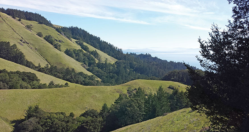
The flank of Mount Tamalpais
A wild turkey scurried across the road like a vision in the vapor.
Walk along the ridge 2.5 miles to Bolinas-Fairfax Road. Cross the road and hike the Bolinas Ridge Trail. It starts in serene redwoods, emerges into an open manzanita and oak forest, then reenters redwoods. As you continue along the rolling ridgeline, the forests alternate for 3.5 miles until McCurdy Trail. (For an alternate route, hiking down Bolinas-Fairfax Road, see The Route, Day 3.)
Descend McCurdy 1.7 miles to CA 1. This is not a well-maintained trail, but it is popular with mountain bikers, who keep it from becoming overgrown. Initially it is steep, but it soon enters the forest and becomes more gradual. Leaving the forest, hike the final mile through beautiful, rolling grasslands, descending into the wooded Olema Valley. You are walking down to the San Andreas Fault.
Turn left on CA 1 for a brief walk on the shoulder. Turn right on Horseshoe Hill Road, a quiet, forested country lane passing by small homesteads. Turn right on Olema Bolinas Road, and hike the walking path into Bolinas along the lagoon past eucalyptus forests, farms, homes, and the site of Gregorio Briones’s original 1837 homestead. Gregorio served in the Mexican army and government for 20 years and received the land grant of Rancho Baulenes for his loyal service. This leg of the journey is all on his land, which stretched from Bolinas south to Stinson Beach, east to Bolinas Ridge, and down to the sea.
Bolinas is not Stinson Beach. It doesn’t reach out to tourists. In fact, you have to know where it is to even find it. For decades the State of California has put up road signs directing motorists to Bolinas, and they are always torn down.
I spent a day in Bolinas exploring and resting. My wife, Heidi, joined me that evening for the final leg of the journey. After walking in solitude for three days, I welcomed her company. A horticulturist by trade, she is also an amateur naturalist and a great companion for a day on the trail.
We had a slow meal of fresh fish at the Coast Café and finished the night at Smiley’s, which claims to be one of the oldest continuously operating saloons in California. Pictures of the bar in the 1800s decorate the walls along with a newspaper article about its 150th anniversary celebration. Smiley’s is a gathering place for locals, many of whom came here during the back-to-the-land movement of the 1960s and ’70s and stayed. A very local band, composed of three ukuleles and an electric bass, played into the night.
When the band took a break, a short woman with a round face joined us at the bar. Her long blonde curls flowed in all directions as if she’d just returned with the fishing fleet after sailing through a fierce gale.
Ordering a beer and a shot of Jose Cuervo, she stuck out her hand and said, “Hi, I’m Michelle. What brings you folks to Bolinas?”
Heidi said, “He’s been hiking for the last three days up from the Marin Headlands. We’re walking to Olema tomorrow.”
“Walkin’! My God. I’ve lived here for 35 years and never walked those trails.” She called the bartender, “Roy, these folks are hikin’ from the Headlands to Olema. You ever done that?”
Roy made his way down the bar. “Hikin’? My truck broke down last week out on Mesa Road, and I had to hike into town. Didn’t like it much. How come you don’t drive? It’s a pretty drive up Highway 1.”
Soon half the bar was debating the merits of a good hike. I asked if there was any kind of taxi service that could bring us back in a few days from Olema to pick up our car.
Michelle laughed. “Oh hell, hon, don’t bother. I’ll pick you up myself. That’s if you don’t mind ridin’ in an old pickup. Call me when you get there.” She wrote down her number on a napkin.
When we left, Michelle had joined the other smokers outside. “There’s the hikers. Nice to meet you folks. Call me from Olema.”
It was a balmy evening, and as we strolled back to our inn, we heard a fellow smoker ask Michelle, “Don’t they have a car?”
Day 4: Bolinas to Olema
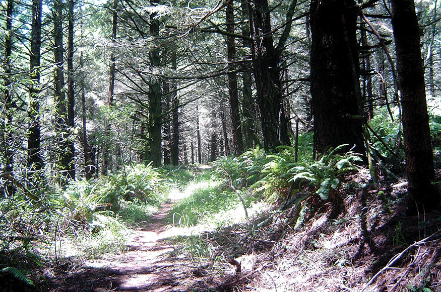
THE FINAL LEG OF THE JOURNEY is 14 miles, but in early June the days in the Bay Area have 15 hours of sunlight, plenty of time for a relaxed pace. Mesa Road, a quiet country lane, travels through ranchland 4 miles to the trailhead in Point Reyes National Seashore. For the next 5 miles the Ridge Trail gradually climbs to 1,200 feet along the crest of the first range of coastal hills. It travels through spruce, fir, bay, and fern forests, periodically opening to glorious views of the Pacific to the west and the Bolinas Ridge to the east. Filtered sunlight shone through the branches like sunbeams through stained glass cathedral windows, and black-tailed does and fawns wandered through the woodlands, curious and unafraid.
I talked about how relaxing it had been to spend days just walking, and the feeling of getting out of my head and into my body. Heidi, a student of Buddhism, said, “Asian religions say the authentic center of the body is in the abdomen just below the navel. The Japanese call it Hara. Chinese Qigong calls it the Dan Tien. Tibetan Buddhists call it wind horse. They say, if you can bring your energy—your ‘wind’—down from your head and into your body, you can ride that wind.” That image can carry a hiker on a long journey.
After a few hours on the Ridge Trail, descend the eastern slope, switching back and forth down to Olema Valley, and head north to Five Brooks, a maze of small streams. Two parallel streams separated by only a few hundred feet flow in opposite directions, Olema Creek north to Tomales Bay and Pine Gulch Creek south to Bolinas Lagoon.
The Rift Zone Trail follows the San Andreas Fault, which formed Olema Valley, Tomales Bay, and Bolinas Lagoon. Thirty million years ago this land started its journey in Central California riding the Pacific Plate as it grinds north at a leisurely 2 inches a year, but it jumped 20 feet on April 18, 1906, the day of the great San Francisco earthquake.
Leaving the park, the trail enters Vedanta Society land. The Hindu society acquired this ranch, with beautiful forests and pasture land, in 1946 and opened this section to hikers and its retreat center to seekers of all faiths. They lease a portion of the land to a local cattle rancher—a contradiction perhaps. The Mount Tamalpais walkabout describes a visit to the Vedanta Society Retreat. The final 5 miles of the trek climbs up forested hills and down into valleys before reaching Olema. It took us 8 hours to hike the final day.
The Ridge Trail
This trip is a mix of short, leisurely days and days of harder hiking. Each village you visit has its own personality: Muir Beach, a bedroom community; Stinson Beach, weekend homes and ready for tourists; Bolinas, many old-timers and happy to stay off the tourists’ radar. Walking through some of the most beautiful wilderness in California and enjoying elegant inns with wonderful dining—what a great way to get to know the Marin Coast.
THE ROUTE
All mileages listed for a given day are cumulative.
Day 1: Marin Headlands to Muir Beach
Starting at eastern end of Rodeo Lagoon, take Miwok Trail to Wolf Ridge Trail, and turn left to Coastal Trail. Descend to Tennessee Valley. 4.0 miles
Continue on Coastal Trail to Muir Beach. Walk up the beach entrance road to Pelican Inn or up the valley on Middle Green Gulch Trail to Green Gulch Farm Zen Center.
total miles 7.0
Day 2: Muir Beach to Stinson Beach
Walk west on the beach entrance road, and take the road that angles right just before the parking lot. Continue past the PRIVATE ROAD sign. This road is open to walkers. Opposite the first house on the left, a paved driveway on the right leads to a cluster of houses with a stairway at the top. Walk up the driveway (a public pathway), and take the stairs. Cross the first street. Continue on the stairs and path past Muir Beach Community Center. Walk left on Seascape Drive to Muir Beach Overlook and CA 1. Walk north on the broad shoulder of CA 1 for 0.5 mile. The wide Coast View Trail is on the right side of the road. Take it to the Dipsea Trail. 4.1 miles
Follow the Dipsea Trail to Stinson Beach.
total miles 6.8
Day 3: Stinson Beach to Bolinas
To reach Willow Camp Trailhead from CA 1, walk east on Calle Del Mar, turn left on Buena Vista, left on Lincoln Avenue, left on Belvedere Avenue, and right on Avenida Farrolone to the trailhead. Hike Willow Camp Trail to Coastal Trail, a steep climb to 1,900 feet. 2.1 miles
Turn left on Coastal Trail to Bolinas-Fairfax Road. 5.3 miles
Cross Bolinas-Fairfax Road and continue on Bolinas Ridge Trail to McCurdy Trail. 8.8 miles
Take McCurdy Trail to CA 1. 10.5 miles
Turn left and walk the shoulder of CA 1 for 0.6 mile to Horseshoe Hill Road and turn right. 11.1 miles
Turn right on Olema-Bolinas Road. 12.6 miles
Hike into Bolinas.
total miles 13.5
Day 3: Alternate Route
Reaching Bolinas-Fairfax Road at 5.3 miles, you can hike down this quiet winding road to CA 1. 9.6 miles
Cross CA 1 and walk Olema-Bolinas Road into Bolinas.
total miles 11.5
Day 4: Bolinas to Olema
Return 0.2 mile on the road into Bolinas to Mesa Road. Turn left on Mesa Road to reach Ridge Trail Trailhead. 4.0 miles
Follow Ridge Trail to Bolema Trail. 8.8 miles
Turn east on Bolema Trail to Olema Valley Trail. 9.9 miles
Turn north (left) on Olema Valley Trail to Rift Zone Trail. Continue north on Rift Zone Trail to Olema.
total miles 14.0
Alternate Trek: An Inexpensive Option
Day 1
Hike from San Francisco over the Golden Gate Bridge to the Marin Headlands Hostel (415-331-2777) on Coastal Trail.
Day 2
Hike to Muir Beach, take Green Gulch Trail, and stay at Green Gulch Farm Zen Center.
Day 3
Hike to Stinson Beach, stay a night, or take the Western Stagecoach bus back to the Golden Gate Bridge.
TRANSPORTATION
Flying into the Bay Area
FROM SFO TAKE BART to Embarcadero Station ($8.95), and follow the public transportation directions below. From Oakland International Airport take the BART Shuttle to the Oakland Coliseum BART Station ($6). Take BART to the San Francisco Embarcadero Station ($4.20), and follow the public transportation directions below.
Public Transportation from San Francisco to the Marin Headlands
VISIT 511.ORG for easy public transportation trip planning.
The Golden Gate Transit Bus 76X goes from San Francisco to the Marin Headlands, but only on weekends. Take BART to downtown San Francisco and exit at the Embarcadero Station. Walk up Market Street a few blocks and catch the 76X at the corner of Sutter and Sansome. The bus will drop you off at the Marin Headlands Visitor Center.
You can take a ferry from the San Francisco Ferry Building to Sausalito any day of the week and then take a taxi to the trailhead. The Society of American Travel Writers ranked this beautiful ferry ride as the second best in the world, next to Hong Kong’s Star Ferry. Take BART to downtown San Francisco and exit at the Embarcadero Station. The Ferry Building is at the foot of Market Street, a short walk from the BART station. Find ferry schedules at goldengateferry.org. The ferry ride to Sausalito costs $12. Taxi fare from Sausalito to the trailhead is approximately $25. Contact Sausalito Taxi at 415-332-5356.
Returning to the Marin Headlands by Public Transportation
THE WEST MARIN STAGECOACH provides bus service from Olema, Bolinas, and Stinson Beach. Contact them at 415-526-3239 or marintransit.org. There are two routes that can drop you off at Marin City, Sausalito, or San Rafael. Taxi fare from Sausalito to Rodeo Beach is approximately $25. Contact Sausalito Taxi at 415-332-5356.
If you take the south route from Bolinas or Stinson Beach and you would like a nice 6-mile hike back into the Headlands, get off at Tam Junction, and hike south on CA 1 for a short distance to Tennessee Valley Road. Turn right on Tennessee Valley Road, walk 0.8 mile, and turn left on Oakwood Valley Trail, which takes you to the Bobcat Trail, which in turn returns you to Rodeo Lagoon.
Pelican Inn
Returning to San Francisco by Public Transportation
IF YOU ARE RETURNING TO SAN FRANCISCO from Bolinas or Stinson Beach, take the West Marin Stagecoach 61 to Marin City ($2). If you are returning to San Francisco from Olema, take the West Marin Stagecoach 68 to the San Rafael Transit Center ($2). Golden Gate Transit Buses will take you into downtown San Francisco from both locations. Go to 511.org to plan your trip.
Driving Directions to the Marin Headlands
FROM SAN FRANCISCO TAKE CA 101 NORTH across the Golden Gate Bridge, and exit immediately at Alexander Avenue. Stay right to get on Alexander Avenue, take the first left, and proceed through the tunnel. If you are driving from the north, take the last exit before the Golden Gate Bridge, turn right, go under the highway, take the first left, and proceed through the tunnel. Continue on Bunker Road, following the signs to Rodeo Beach. Miwok Trail starts at the eastern end of Rodeo Lagoon.
MAPS
THE NATIONAL PARK SERVICE provides free downloadable maps at nps.gov. Marin Headlands and Golden Gate National Recreation Area are good for Days 1 and 2.
National Geographic’s Mount Tamalpais, Point Reyes Trail Map ($11.95) at shop.nationalgeographic.com is an excellent map.
Map Adventures also publishes good maps for this walkabout: Mount Tam Hiking and Biking Trail Map ($10.95) and Point Reyes Hiking and Biking Trail Map ($10.95). Visit mapadventures.com.
PLACES TO STAY

Muir Beach
PELICAN INN $$$$ • 10 Pacific Way at CA 1 • 415-383-6000 • pelicaninn.com • Includes a hearty breakfast. Fun 16th-century English country–style inn. Nice pub and restaurant.
GREEN GULCH FARM ZEN CENTER $–$$$$ • 1601 Shoreline Hwy. • 415-383-3134 • sfzc.org/green-gulch • Three delicious vegetarian meals included. Single and double rooms in a beautiful, contemplative setting. A short walk up the valley from Muir Beach.
Stinson Beach
SANDPIPER LODGING AT THE BEACH $$–$$$$ • 1 Marine Way • 415-868-1632 • sandpiperstinsonbeach.com
REDWOODS HAUS B&B $$–$$$ • 1 Belvedere and CA 1 • 415-868-1034 • redwoodhaus.com • Breakfast included.
Bolinas
SMILEY’S SCHOONER SALOON AND HOTEL $$–$$$ • 41 Wharf Road • 415-881-1851 • smileyssaloon.com
ELEVEN $$–$$$ • 11 Wharf Road • 415-868-1133 • 11wharfroad.com
GRAND HOTEL $ • 15 Brighton Ave. • 415-868-1757
Olema
OLEMA HOUSE (formerly The Lodge at Point Reyes) $$$$ • 10021 CA 1 • 415-663-9000 • olemahouse.com
ROBIN’S RETREAT AND HONEYBEE COTTAGE $$–$$$ • 10210 Shoreline Hwy. • 415-663-1288 • robinsretreat.com
INN AT ROUNDSTONE FARM $$ • 9940 Sir Francis Drake Blvd. • 415-663-1020 • roundstonefarm.com
BEAR VALLEY COTTAGE $$$$ • 88 Bear Valley Road • 415-663-1777 • bearvalleycottage.com • 15% discount for those hiking in.