39 SALMON RIVER
DISTANCE: 5.2-mile out-and-back for lower section, 6.6-mile out-and-back for upper section
DIFFICULTY: Easy all the way to the campsites in the upper section, moderate–strenuous beyond that
SCENERY: Old-growth forest, spawning salmon in spring and fall, canyon view at top
EXPOSURE: Shady all the way to the top, where there are exposed rocks
TRAFFIC: Heavy all summer long
TRAIL SURFACE: Packed dirt, with rocks and roots
HIKING TIME: 2 hours for lower section, 3.5 hours for upper section
ELEVATION CHANGE: 200' in lower section, 950' in upper section
SEASON: Year-round; gets snow in winter
BEST TIME: October for the colors and salmon
BACKPACKING OPTIONS: Nice sites in the upper section
DRIVING DISTANCE: 50 miles (1 hour, 15 minutes) from Pioneer Courthouse Square
ACCESS: Northwest Forest Pass required
MAPS: USFS Salmon-Huckleberry Wilderness
WHEELCHAIR ACCESS: No
FACILITIES: Usually an outhouse at the upper trailhead; water and restrooms at Green Canyon Campground
CONTACT: Zigzag Ranger District, 503-622-3191, www.fs.usda.gov/mthood
LOCATION: Salmon River Trail on East Salmon River Road, 5 miles south of Welches, OR
COMMENTS: The Salmon River, which starts on the slopes of Timberline Ski Area, is the only river in the lower 48 states that is classified as a Wild and Scenic River from its headwaters to its mouth. To see its headwaters and ford it where you can skip across, do the Barlow Pass or Timberline Lodge trip, respectively.
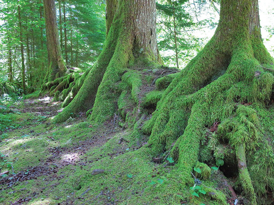
Three trees taking full advantage of a nurse log
THIS TRAIL CAN be thought of as having three sections: The upper and lower sections, described here, are easy to get to, and in the fall they host spawning salmon. The uppermost section, accessed by a different road near Trillium Lake, is less interesting and tougher to find; its only advantage is that hardly anybody hikes it. Hardier hikers can take an optional side trip to Devils Peak.
DESCRIPTION
Lower Section
This is Old Salmon River Trail #742A. From the roadside parking area (the first one you came to while driving in), you’ll start out downhill through a forest of Douglas-firs and western red cedars. You’ll be close to the river after 0.1 mile and follow it most of the way. (You’ll also pass access to four other trailheads along the road, so be sure to remember where you left your car.) After two footbridges over side creeks, you come to the first of several trails leading down to the river. You’ll pass two more small bridges and, after 0.4 mile, come to a campsite where a log sticks out over the river. It’s perfectly sturdy, but be sure of your balance before you go out on it.
The best thing about this trail, other than its convenience and the river itself, is the nature of the old-growth forest. Look for nurse logs—fallen trees that are now the home of new trees. Just past the campsite with the suspended log, you’ll climb a set of steps, at the top of which is a massive western red cedar. You can’t miss it—it’s right next to the trail and about 10 feet thick at its base. At about the 1-mile mark, look for a hollowed-out cedar stump with a new tree growing from it; just past it is the biggest Douglas-fir (about 8 feet in diameter) on this stretch of the trail.
At about the 1.5-mile mark, you’ll come to the first of two sections where the trail briefly joins the road. Take the second trail back into the woods; the first trail is used by anglers and dead-ends at the river. Continue 50 yards and look for three large trees—two firs and a cedar—that are almost bonded together. Just past here, where a downed tree lies along the bank, I came across several spawning salmon on a late-September hike. They were in the shallows just a few feet from shore. The fish will actually go several miles farther upstream; if you hike the upper section of this trail in the fall, you’ll get more chances to see them.
There are two more highlights to this trail. One is a cedar tree so large that a hollowed-out area in its base is big enough to be called a cave. The other is a nurse log, cut into three pieces for trail-construction purposes, that is now host to no fewer than eight saplings.
When you’ve hiked a little more than 2 miles, you’ll come to Green Canyon Campground, which has an outhouse and water. Then, after a second section on the roadside, you’ll briefly drop back into the woods before emerging at the upper trailhead, where the road crosses the river.
Upper Section
Now for Salmon River Trail #742. From the trailhead at the bridge, walk upstream through a forest replete with massive Douglas-firs. Just less than 0.5 mile up, you’ll pass a deep pool, where anglers often gather. A short distance past this, when you get another view of the river from about 40 feet above it, look (in September and October) for dark shapes swirling about in the pools. Those are salmon: the black-gray ones are chinook, and the less-often-seen gold ones are coho. Consider that they have spent their lives in the ocean and have swum some 75 miles up the Columbia River, about 41 miles up the Sandy, then about 20 miles up the Salmon.
At 1.5 miles, pass Bighorn Camp; then at the 2-mile mark, reach Rolling Riffle Camp, where a trail to the right leads to a little falls and deep pool. Beyond you’ll pass the wilderness boundary and embark on your only real climb of the day, picking up nearly 600 feet in 1.3 miles on your way to an overlook of Salmon River Canyon. Go as far as the rock outcrop for the best view. Be very careful, and don’t try any of the trails heading down toward the river—you might descend faster than intended.
Devils Peak Option
That scenic view is your recommended turnaround, as you’re now 3.3 miles from the upper trailhead, but the trail goes another 10.8 miles upstream to a road near Trillium Lake. If you’re feeling industrious, put in the big climb to the lookout tower at Devils Peak. Just continue 2.3 miles up Salmon River Trail #742, then turn left to climb Kinzel Lake Trail #665, following it 2.3 miles (and 1,600 feet) up to Hunchback Trail #793, which leads 1.6 miles (and another 700 feet) up to the 5,045-foot lookout. If you started at the bridge, you’re looking at 9.8 miles one-way with a climb of 3,400 feet. You have other options for getting up there, but this one would be good as part of an overnight trip.
NEARBY ACTIVITIES
Start your day with French toast at the Zigzag Inn, 0.1 mile east of Salmon River Road (70162 US 26, Welches, OR; 503-622-4779; zigzaginn.com).

GPS TRAILHEAD COORDINATES N45° 18.646' W121° 56.615'
DIRECTIONS Take US 26 from Portland, driving 36 miles east of I-205. Turn right on Salmon River Road. Continue 2.7 miles to reach the lower trailhead, just beyond the sign for Mount Hood National Forest, or drive 4.9 miles to the upper trailhead, at a bridge over the river.