60 WILLAMETTE RIVER GREENWAY
DISTANCE & CONFIGURATION: One-way, out-and-back, or big loop, with options of up to 12.2 miles
DIFFICULTY: Easy terrain, moderate difficulty depending on how far you go
SCENERY: City, river, forests, amusement park
EXPOSURE: In and out of the sun
TRAFFIC: Moderate–heavy
TRAIL SURFACE: Paved
HIKING TIME: 6 hours to do it all
ELEVATION CHANGE: Virtually none
SEASON: Year-round
BEST TIME: Anytime you want
BACKPACKING OPTIONS: None
DRIVING DISTANCE: None. See Description (starting on) for transit access.
ACCESS: Parking fees or TriMet pass ($2.50 ages 18–64, $1 seniors 65+)
MAPS: Available from the Travel Portland visitor center (701 SW Sixth Ave., Portland, OR)
WHEELCHAIR ACCESS: Yes
FACILITIES: Several places along the way
CONTACT: Travel Portland, 503-275-8355, travelportland.com
LOCATION: Central Portland
COMMENTS: The South Waterfront area is still seeing some construction and might be a little different when you get there, but it will be much the same and easy to follow.
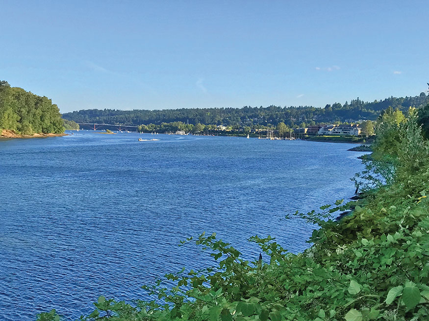
View south from the Greenway Trail, with Sellwood Bridge in the distance
TOUR CENTRAL PORTLAND and the Willamette River on a series of paved walkways. You can piece this one together on different days, mixing in tourist activities, or do it all in a pleasant day of wandering. It’s a fine introduction to some of Portland’s cooler elements, combining city access with peaceful natural spaces.
DESCRIPTION
I’ve broken this hike into several different sections, each with access points from the Portland Streetcar, MAX Light Rail, or TriMet Bus.
Portland Aerial Tram to Steel Bridge (2.4 miles)
South Access Portland Streetcar, SW Moody/Gibbs Stop (12760)
North Access MAX Light Rail, Old Town/Chinatown Station (8339)
From the Portland Streetcar stop (NS Line) at the base of the Portland Aerial Tram, walk north on SW Moody Avenue. You’ll pass Tilikum Crossing bridge, one of many opportunities to make a shorter loop. But even if you’re going all the way around, walk out to enjoy the view. At the far end is the Oregon Museum of Science and Industry (OMSI) and a streetcar/MAX stop. Otherwise, continue up Moody, passing under the Ross Island Bridge and soon coming to River Parkway, 0.8 mile north of the tram. Turn right on River Parkway and look for where the path resumes, at a viewpoint under the I-5 Marquam Bridge. You’ll be overlooking Poet’s Beach, which offers river access and “inspired thoughts” engraved in stone. To the right, when this book was written, was a big open space, through which the path will go someday.
The next section of northbound trail reaches South Waterfront Garden in 0.3 mile; here you can walk down a dock with access to the river. The path continues through the RiverPlace neighborhood before coming onto the large (and often goose-filled) lawn in Tom McCall Waterfront Park. Just beyond is the Hawthorne Bridge, where you can find restrooms as well as stairs that access the bridge. Walk across the river to pick up another section of this walk on the other side.
Still on the west side, the path now enters a much-loved stretch of land. McCall Park was once a highway, but that was torn out to create a grassy, riverside expanse that’s home to picnickers, disc tossers, and a series of festivals. You may also notice huge steel bollards; these secure ships during the annual Rose Festival, when McCall is filled with an amusement park. Along this stretch, you’ll eventually arrive at the Burnside Bridge and the site of the Portland Saturday Market, which actually happens both weekend days from March through Christmas.
Just beyond the bridge is the Japanese Historical Plaza, whose cherry trees provide hope and color to rain-soaked locals in March. At the other end—1 mile north of the Hawthorne—you reach the Steel Bridge and the end of this section. The Old Town/Chinatown MAX Station is one block west, on NW Davis Street.
North of the Steel Bridge (1.4 miles round-trip)
South Access MAX Light Rail, Old Town/Chinatown Station (8339)
North Access Portland Streetcar, NW 10th/Northrup Stop (13604)
This flat and fairly quiet extension of the Willamette Greenway Trail is either an out-and-back for those doing the full loop or another exit that will lead you to the Pearl District. From the Steel Bridge, walk north across the railroad tracks, and look for a WILLAMETTE GREENWAY TRAIL sign leading right. Follow the path north, between condos and the river, and take note of the reminders that there’s still a port in Portland: the grain elevators across the way and the seagoing vessels being serviced along the other side of the Willamette. Also look across the way for the arenas in the Rose Quarter.
The path soon turns to boardwalk and you pass under the Broadway Bridge then reach a viewing platform at the corner of the 1909 Albers Mill Building. Past that are much-more-modern condos with their fancy glass and water features. The trail ends at the corner of NW Ninth Avenue and Naito Parkway—at least it did at press time.
To reach Portland Streetcar Stop 13604, near Tanner Springs Park in the Pearl, walk across Naito Parkway and the railroad tracks on NW Ninth Avenue, walk one block, and turn right onto NW Northrup Street.
Steel Bridge to OMSI (1.5 miles)
North Access MAX Light Rail, Old Town/Chinatown Station (8339)
South Access Portland Streetcar, SE Water/OMSI Stop (13615)
Walk across the Steel Bridge, on either the upper or lower section. At the east end of the 890-foot walkway, turn right onto the Vera Katz Eastbank Esplanade. Enjoy the 280 trees and 43,695 shrubs (most native) planted along the trail, and in a few minutes come to the floating walkway. At 1,200 feet, it’s the longest in the world. It’s held in place by 65 pylons, each sunk 30 feet into the bottom of the river. Each section weighs 800,000 pounds, yet you can still feel it bobbing up and down. If you want to head back to the west side, you can do so on the Burnside Bridge via a staircase on the south side.
After passing under the Morrison Bridge (also accessible via a ramp), you’ll see what looks like a strange rock formation; this is leftover concrete, dumped when the Morrison Bridge was being built. Just past the Hawthorne Bridge, which has a lookout point on the north side and access to cross back over the river, you’ll come to OMSI. The path goes across the front of OMSI (past the submarine); a minute or two past that, you’ll come to the east end of Tilikum Crossing, where the Streetcar/MAX stop is 50 yards to your left.
OMSI to Sellwood Bridge (3.9 miles)
North Access Portland Streetcar, SE Water/OMSI Stop (13615)
South Access TriMet Bus, SE 13th/Tacoma Stop (6709) or Sellwood Riverfront Park
Pass under Tilikum Crossing, where there is some cool artwork, and then to the end of the Esplanade section at Caruthers Landing, where you’ll get a viewpoint to the Portland Spirit’s home dock. Now walk away from the river on SE Caruthers Street for a block, then right onto SE Fourth Avenue. In two blocks, enter the Springwater Corridor Trail, a 21-mile former rail line that goes to the town of Boring.
Around the first mile marker you’ll come to a series of grassy areas with benches and an art installation, as well as the Ross Island Sand and Gravel Company.
A third of a mile later, look for a trail leading right, into the woods; take it for a respite from the concrete and bikers. You’ll wander 0.6 mile through cottonwood forest with several views of the river then rejoin the main path at an entrance for Oaks Bottom Wildlife Refuge. Here you can either stick with the main, paved path headed south or cross under the tracks into the refuge. There, make a couple of right turns, walking along a large pond and then cutting back over to this path.
Either way, you’ll arrive at Oaks Amusement Park and, just past that, SE Spokane Street at Sellwood Riverfront Park. The Springwater Corridor Trail keeps going, and you can explore that way if you’d like. We’ll go left on Spokane two blocks, right on SE Sixth Avenue, and right on SE Tacoma Street to head over Sellwood Bridge. Or left for a world of coffee shops, cafés, and antiques dealers in Sellwood.
Sellwood Bridge to OSHU Tram (2.9 miles)
South Access TriMet Bus, SE 13th/Tacoma Stop (6709) or Sellwood Riverfront Park
North Access Portland Streetcar, SW Moody/Gibbs Stop (12760)
At the west end of the Sellwood Bridge, follow the path down, around, under the bridge, and back onto the Willamette River Greenway. (The obvious wooded area south of here is Powers Marine Park; when this was written it was still closed.) Heading north, you will pass Willamette Moorage Natural Area, where Stephens Creek actually has salmon and steelhead runs. Next up is Butterfly Park and then Willamette Park. Now you’re back to an open riverside path, passing the Willamette Sailing Club and then reentering the world of condos. The 1.2 miles north of Willamette Park offer constant views of the river, and you’ll pass benches, docks, and beaches.
After passing the River Forum office building on the left, you’ll have to get around some private property by cutting through the office park, but the signs are easy to follow. (This area, the last gap in the trail, was slated for construction at press time, so it might connect through when you get there.) You’ll arrive at SW Bancroft Street; turn right and walk a block to SW Bond Avenue. You can enjoy a brief riverside section by the Old Spaghetti Factory or head up Bond to SW Gaines and turn right to resume the riverside trail for a bit. After coming to a viewpoint of the Ross Island Bridge, turn west along SW Curry Street, and follow it three blocks to Moody. Turn right, and in two blocks you’ll be at the base of the Portland Aerial Tram.
Or the entire above paragraph will have been replaced by a whole new section of riverside trail connecting to Poet’s Beach.

GPS TRAILHEAD COORDINATES N45° 29.917' W122° 40.311'
DIRECTIONS See the public-transit access points for each section in the Description.