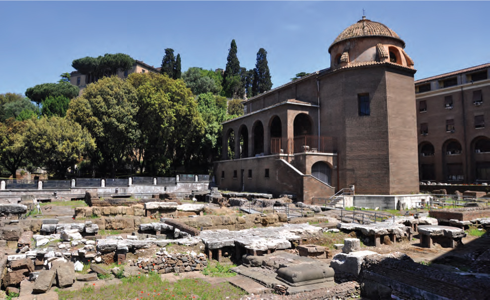
During rapid excavation for a new thoroughfare near the Tiber in the 1930s, archaeologists uncovered a large ancient Roman sanctuary around the medieval church of S. Omobono (fig. 4). The Republican-Era twin temples there have become a highlight of Roman architecture and are particularly famous for being raised together on a platform high above the surrounding valley. Of course, they are not the only significant finds from the site, or the oldest. As archaeologists began to investigate ancient remains more extensively, they pulled slabs from the pavement of the platform and found a deep earthen fill inside. The fill had been deposited as part of the foundation material for the flagged plaza in front of the temples, a standard means to save on stone and support non-load-bearing pavement in a raised complex.1 As the perimeter walls of the platform went up in antiquity, workers would have deposited load after load of earth within and then capped the mass with stone pavers. About twenty-five hundred years later, when excavators began to look through debris in the fill, they uncovered striking finds. Buried within were fragments of pottery from as far back as the fourteenth century BCE, including numerous examples of Apennine ware from the twelfth century.2 Rome, it seems, is far older even than the tales of Aeneas coming ashore after the Trojan Wars.
The ceramics from the S. Omobono fill were an extraordinary find, but, sadly, with their removal in antiquity from an original context and their highly fragmented state of preservation, they provide scant information about the character of habitation. Still, more evidence for early communities at Rome has appeared in subsequent excavations, and these new finds indicate that early settlers on the Capitoline and by the riverside stayed on past the Bronze Age as part of an ongoing habitation.3 They reveal the existence of distinct communities scattered atop the hills and a burial culture that fits well in a broadly defined Central Italic, proto-Villanovan culture that slowly shifted to a fossa burial culture.4 In the mid-tenth century, things begin to change, and evidence of these ongoing burials begins to appear on and around the Palatine, Capitoline, Quirinal, and Esquiline hills in a broader context with small huts and land cultivation. In addition to the telltale postholes and fragments of daub from Iron Age huts, as well as seeds and furrows from early farmsteads on the Palatine and Capitoline, the ground along the slopes of these hills has given up graves that attest to a people ceremoniously burying their dead through both cremation and inhumation.5 Widespread nucleation of these settlements on the hills was slow, but by the late ninth and early eighth centuries, wells containing domestic debris on the Velia reveal a clustered settlement there, and graves on the far eastern Esquiline and Quirinal plateaus indicate communities on those hills with nearby necropoleis, just like those at the bases of the Velia, Palatine, and Capitoline.6 The early image is hazy, but by the start of the eighth century, the famous hills of Rome seem to have supported substantial settlements.
FIGURE 4
Site of S. Omobono, view from the southwest.
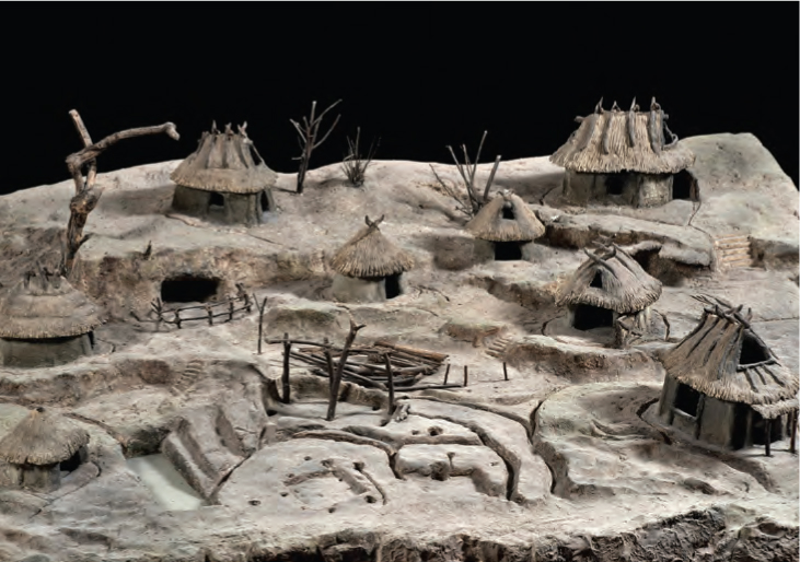
Beginning in the early to mid-eighth century, a picture of these settlements becomes clearer. On the Palatine especially, periodic excavations from 1907 to 1954 revealed postholes, infant burials, domestic ceramics, and fragments of daub that attest to clusters of homes. The most famous group is on the Germalos, where archaeologists discerned several huts—including the so-called hut of Romulus—from the arrangement of postholes and furrows for wattle-and-daub walls. A mass of broken ceramics, now embedded in two plaster cases mounted on the walls of the Palatine Antiquarium, helps date occupation of the huts from the late ninth to mid-seventh century (figs. 5, 6).7 Beneath the Aula Regia and Lararium of the later Domus Augustana, archaeologists found more postholes and materials dating to the eighth century as well as evidence of infant burials—typically associated with domestic structures—beneath a packed earth floor, upon which burned fragments of daub revealed the presence of more huts.8 These are closer to the center of the Palatine, suggesting that habitation existed all across the hilltop. Similar remains dating through the mid-seventh century have been found beneath archaic houses in the Palatine “North Slope” excavations, below the later Regia and Atrium Vestae, and atop the nearby necropolis known as the Sepulcretum on the Velia slope (see fig. 1, box 1).9 Overall, curvilinear wattle-and-daub huts of small to modest sizes and various levels of elaboration can be reconstructed atop the Palatine and reaching the edge of the Forum basin by the early to mid-seventh century. Recent excavation has uncovered daub fragments and agricultural plots on the Capitoline, indicating that similar structures existed atop that hill in the eighth and seventh centuries, and scholars have long since identified habitation atop the Velia, near wells with detritus from the same period, and on the Quirinal and Esquiline, at the communities that are represented by early burials on those hills.
FIGURE 5
Palatine. View of the area of huts on the southwest slope of the Germalos, including postholes and wall trenches.
At the same time, sacrificial and votive remains from the northwest Quirinal, the south Capitoline at S. Omobono, and the northwest and northeast Palatine slopes reveal religious spaces scattered across the hills.10 Some kind of architecture may have adorned the sites already in the eighth century, but no absolute indication of a temple building has yet been found. A few plain tiles discovered in the lower strata at the sanctuary by S. Omobono may indicate a pisé building that predates the famous first temple of ca. 580, but the early stratigraphy of that site is problematic and the tiles could date any time before ca. 590, even just a few decades prior.11 On the eastern slope of the Palatine Hill, by the Colosseum valley, excavations continue to reveal evidence of early cult activity and perhaps even a venue for civic congregation at a heavily trafficked crossroads.12 The settlements on the hills certainly hosted religious activity, but it remained dispersed, and there is no certain evidence of architectural elaboration quite this early.
FIGURE 6
Model of wattle-and-daub huts from the Germalos. Palatine Antiquarium.
Just as these spaces took shape and as people built more and more huts on the hills, they may also have built some of the earliest boundary walls for the settlements. On the north slope of the Palatine, archaeologists have uncovered two thick walls built successively that date sometime in the mid-eighth to early seventh century and to the late seventh century, respectively, but varying interpretations of the scarce finds leave their precise function open to debate.13 At 1.4 to 2.4 meters wide, they are far thicker than the hut walls from this period, which are just 0.4 to 0.5 meters thick, but their size alone cannot necessarily indicate that they are urban boundaries. Although some have tied them to literary testimony of an early ritual wall, one scholar has suggested they could be drainage canals or a terracing foundation, and there are simply not enough clues to settle on one interpretation.14 Even if the thick mural segments do correspond to the ritual boundary that ancient sources say surrounded the Palatine Hill, it still remains unclear whether they were meant to segregate the Palatine from neighboring hilltop communities or if instead there was a unified effort underway to fortify each of the hills against aggressors from other cities. Evidence from the Capitoline of a wall built in the eighth to seventh centuries along the southeast side, by the later Carcer, would seem to suggest distinct walls cordoning off each of the hills. Of course, they could have been part of a unified effort, but this is hardly discernable from the current state of the evidence.15
What is clear is that by the middle of the seventh century, there is direct evidence of substantial communities on the hills of Rome. Large and small huts, floral and faunal materials, and burials distributed all across the hilltops reveal clusters of collective habitation, with a few distinct civic and religious spaces spreading over the Palatine to the Velia and Esquiline, and from the Capitoline to the Quirinal. It should be said that such communities may also have existed on the Caelian and Aventine, but no excavation down to these levels has as yet been carried out there.
As excavation and research have uncovered more and more evidence for domestic and religious spaces on the hills, this material has been woven increasingly into a complex debate over the chronology of Rome’s genesis as a city and a state. Over the twentieth century and even before, the broad conceptual parameters for defining what exactly constitutes a city or a state have seen heavy debate, and as scholars have determined different systems for defining each, one thing has become clear: their identification by way of archaeological remains is a particularly thorny problem in early Central Italy.16
The genesis of a unified Roman city-state has itself seen a wealth of scholarship, especially since the middle of the twentieth century. Already in 1905, Giovanni Pinza had questioned how archaeological evidence, especially from graves, might uphold the textual tradition of monarchy and state formation.17 His study laid a foundation for those who wished to juxtapose archaeology and text in the formative days of Roman history. As part of his research into material evidence for early Rome, Einar Gjerstad revisited the question and proposed a radical reappraisal of the traditional narrative. He suggested that state formation did not truly occur until the late seventh or early sixth century, well into the traditional years of the Roman monarchy.18 For Gjerstad, whatever happened in the decades after the putative foundation of Rome in ca. 753, a unified city across the hills and valleys began to appear only ca. 600–580, with the first Forum pavement and the creation of civic spaces there, on the Capitoline, and at the port, by S. Omobono. His assessment put the genesis of a Roman city-state later than most, well after the escalation in hut construction and religious spaces mentioned thus far. As with most of his study, Gjerstad’s argument for a late unification prompted debate, and Hermann Müller-Karpe responded to the contrary. He argued that such a buildup of civic construction in the late seventh and early sixth centuries, alongside evidence for the communal transposition of graves in the eighth and seventh centuries and an increase in local craftsmanship at that time, suggested a converging community at Rome already in the eighth century, just as ancient sources say.19 For Müller-Karpe, heavy construction in the Forum and elsewhere in the late seventh and early sixth centuries was evidence of a mature polity that must have existed in unification for some time before the creation of its first monuments. These two camps have largely defined the field, with scholarly consensus vacillating between the two over the years since.20
Evidence discovered since the years of Gjerstad and Müller-Karpe’s debate does not bring absolute clarity to the situation. In part, it has confirmed what Müller-Karpe stressed. From the tenth to the eighth centuries at Rome, an increase in burial wealth, a social hierarchy witnessed within those burials, hut construction on many of the hills, and costly imports throughout the necropoleis suggest there was a rise in the scale of settlements and of social stratification.21 The evidence fits comfortably alongside remains at Etruscan, Latin, Sabine, Faliscan, and other settlements, all of which reveal a long gestation beginning as early as the late Bronze Age and continuing into the early Iron Age. As Renato Peroni defines them, these “proto-urban” centers were at first nothing more than giant villages.22 Early on, they show no signs of the monumental architecture or developed legal and religious systemization that city-states would have, but they were notionally coherent (if physically discontinuous), sprawling communities where huts, pasture, and necropoleis hosted perhaps thousands of people. Over the tenth to eighth centuries, some of these sites show evidence of increasingly impressive mercantilism and a few cult spaces, revealed by votive and ceremonial deposits; what is more, they were generally large enough that some kind of corporate social structure would have been necessary.23 At many settlements, state, city, and cohesive community appear in gossamer forms of their later instantiations. Although potentially teleological in application (and especially in the name “proto-urban”), the existence of this phenomenon in Central Italy is hard to dispute.
Most of these “proto-urban” centers emerged in the tenth to ninth centuries on plateaus and hilltops. As these communities grew, nearby smaller villages dwindled, apparently the result of migration to the larger centers. This was the case throughout Central Italy and has been identified widely in Etruscan, Sabine, Latin, and other territories, but there were substantial differences in the sizes of these centers.24 Most were settled on single hilltops with inhabited areas of some thirty to fifty hectares. Exceptions are found only at Veii, Vulci, Caere, and Tarquinii in southern coastal Etruria, where vast plateaus allowed settlements as large as one hundred to two hundred hectares.25 This appears largely to be the result of the geographic availability of such large raised areas near rivers and coastlines. Overall, the communities began to take shape by the end of the second millennium, and here and there, they dotted the landscape with more frequency as the centuries passed. Though the trend was neither universal of the whole of Central Italy nor simultaneous, it did characterize the region during the late Bronze Age and early Iron Age, and where it did occur, it appears to have happened in a relatively uniform manner. Rome, though, is a special case.
Each of the hilltops at Rome fits the most common size paradigm for the region; they were not the massive plateaus of the four southern Etruscan centers. Rather, the Palatine, Capitoline, and other hills that were first settled comprise spaces of just thirty to fifty hectares each.26 What makes Rome unique is that, in contrast to nearly every other settlement in Central Italy, the small hills at Rome were not settled in isolation. Rather, there were several of these thirty-to-fifty-hectare spaces clustered so tightly together that, eventually, their size and proximity would require them either to exist in constant conflict or to join together. By the end of the archaic period, they would follow the latter course and cohere in a sprawling two-hundred-plus-hectare polity, the only one in Latium to rival the size of four large southern coastal Etruscan polities.27 The question is when this consolidation happened; at what point did the settlements on the Tiber cohere to create a single center?
Although the proximity of the hills allowed for eventual cohesion, archaeologists agree that they were geographically distinct enough to create substantial division early on. The small communities on the Capitoline, Quirinal, Palatine, and Velia had their own necropoleis; the low valleys between them kept settlements from connecting easily, especially because of seasonal floods; and all evidence points to discrete communities in the formative years.28 As these hilltop centers grew, as burial wealth begins to indicate social stratification, and as nearby smaller villages collapsed, discrete proto-urban centers on the Capitoline and Palatine would have emerged. Almost as quickly, they would have distinguished themselves and the potential for conflict would have arisen, and soon—perhaps as the result of conflict or perhaps to stave it off—they would have begun to communicate. Two large, powerful centers so close could not have coexisted as separate, competing settlements for long, and, increasingly, scholars see evidence of heightened communication and cooperation among the hilltops already in the ninth and early eighth centuries. That is when distinct necropoleis for separate Palatine, Velia, Quirinal, and Capitoline communities go into disuse, and a larger communal necropolis on the far eastern Esquiline and Quirinal appears.29 Some still see this as evidence of two distinct Capitoline-Quirinal and Palatine-Velia-Esquiline settlements, but more and more, scholarship on proto-urban development and the sprawling, connected necropoleis on their peripheries suggests this would have been a unified enterprise.
Thus, by the mid-eighth century, the Palatine, Capitoline, Velia, Esquiline, and Quirinal appear to have begun cooperating as an impressive center, where a socially stratified population communicated at least about burial practices. These indications of communal activity are widely acknowledged, but they should not be mistaken for an indication that Rome had become a fully unified urban polity by the late eighth century: there is no real indication that the city and state of Rome had formed by then, or even by the mid-seventh century.
Some scholars have challenged this, and they push for a comprehensive interpretation of a Roman city-state already in the mid-eighth century based on a smattering of clues.30 The alleged evidence for this lies principally in the wall on the northern Palatine, which in its most far-reaching interpretation has been construed as a religious boundary and linked with the ritual plowing of an urban circuit. Additionally, scholars have highlighted a few earthen pathways near this wall and by the later Regia and Atrium Vestae as well as remains from the votive/ceremonial deposits on the Capitoline and Quirinal.31 The pathway at the later area of the Regia certainly exists, but it is small and patchy, and the functions of the areas around it are unclear; any connection with textual traditions of Vestals or kings requires a trusting reading of unreliable (and contradictory) literary sources.32 The rest of the material is hardly evidence of urbanization. The votive deposits that date before the mid-seventh century are all on the Quirinal, Capitoline, and Palatine; they are isolated and small. They are either high atop the distinct hills, or they are minor deposits like those on the northwest and northeast Palatine slopes, at the later Atrium Vestae, and in the Colosseum valley excavation. There is no evidence that such cult spaces were used by all the hills, or as a socio-religious focus that connected the settlement. In fact, they seem more an indication of distinct cult sites for separate communities. There certainly is not enough evidence to suggest that they were unifying socio-religious centers, the kind that might indicate urban and state development under some theories.33 The walls on the north slope of the Palatine and east Capitoline are equally ambiguous, since they could have had many uses, as religious or political boundaries or even as terracing walls. Even if they were religious boundaries for established communities, such barriers are hardly an indication of cohesion or urbanism across the hills; if anything, they would suggest division, boundaries that cordoned off the Palatine and Capitoline communities from each other and from the other hills.
With so little evidence for clear communal sites, and without the kind of connected geography that one finds at other places in Central Italy, the picture is somewhat hazy for Rome, especially from the ninth to seventh centuries. Settlements appear to have cohered in some ways by the early Iron Age, but it is difficult to say just how far-reaching the process was by the eighth and seventh centuries. There is evidence for shared decisions regarding burial and of rich and distributed grave goods, and there is a slow expansion of settlements on each of the hilltops. These changes certainly indicate an increasingly dense and socially stratified population, but there remains no real evidence for an urban architectural fabric creating a city across the hills or of civic organizations to bind the communities as a fully cohesive and interdependent state.
These cautions notwithstanding, the shift toward a more connected settlement at Rome is critical. The extent to which these communities had grown, stratified socially, and begun to communicate indicates at least the first vestiges of a cohering Rome, a rambling group of communities on the hills that was communicating already in the eighth century and that saw increased connectivity in the early seventh. Without subscribing to a teleological perspective,34 this is as far as one can go with the evidence until the mid-seventh century.
Despite any efforts at communication and cohesion, those living in this proto-urban environment on the hills would have experienced routine, visible, and tangible proof of their division. Their settlements overlooked vast floodplains that stretched through the Campus Martius; between the Capitoline and Palatine to the feet of the Quirinal and Esquiline spurs; and up through the Circus Maximus valley, between the Palatine and Caelian to the Colosseum valley (fig. 7 and see fig. 1). 35 In a groundbreaking program of research, Albert Ammerman and several collaborators took deep cores from the slopes of Rome’s hills and valleys in an attempt to assess geography and urban expansion during the eighth and seventh centuries. Based on several criteria, they determined that in these basins, annual floods would have prevented permanent construction. In antiquity, the Tiber—Rome’s outlet to the Mediterranean—rose to between nine and ten meters above sea level in winter and spring months, inundating low-lying areas. At the same time, streams in the center of the valleys would have collected heavy runoff from the hills, while excess waters that bubbled up in springs in the gravel beds, such as the Lacus Iuturnae, further contributed to inundation. As the streams expanded with rainwater in wetter months, the lower elevations close to the Tiber would also become inundated with its rising waters, and eventually the entire lowland of Rome would flood.36
For some time each year, the Palatine, Capitoline, and Aventine would be isolated from one another. The only piece of land connecting the Palatine to the surrounding hills for that period of flood would be the strip of the Velia between the later Regia and Arch of Constantine.37 The same would be true of the Capitoline, surrounded by the low Campus Martius, riverside, and Forum basin and connected only by a thin saddle to the Quirinal Hill. The Aventine would be even more removed, with the flooded Circus Maximus valley and river isolating it. What is more, the floods would not only confine the hills, but they would also destroy any building made in water-soluble material that was in their path; since wattle and daub, pisé, and mud brick—all subject to ruin even when partially inundated—remained the only building blocks of architecture in Rome and Central Italy until the late seventh century, the valleys would have been off-limits for long-term construction and ongoing habitation.38 Thus, the studies suggest that any “proto-urban” communities that developed in Rome would have been restricted to the hilltops until the end of the seventh century.
On further investigation, this is precisely what the wider archaeological record has borne out. Remains of early cults, areas of habitation, and civic structures have only been found atop the hills and on their upper slopes. Excavations and cores down to virgin soil in the Forum, Colosseum valley, and Velabrum and along the riverside have not revealed any substantial attempts at architecture in the low basins, and textual sources do not mention active cults or habitation dating before the middle Republic (ca. 350) in the area of the Velabrum and lower Forum Boarium, or before the sixth century in the middle of the Forum Romanum.39 These are precisely the dates when (by gradual accretion or purposeful intervention) ground level in these areas rose above the annual flood level. Thus, while the valleys were below the Tiber’s flood level, they would hold only a few temporary structures, if anything at all; more than this—homes and permanent civic structures especially—would have proven prohibitively burdensome to rebuild every nine months. As long as Romans built in these materials, topographical change was confined to the hills, and therefore, until the late seventh century, the urban image of Rome resembled other Mediterranean communities: hilltop settlements overlooking low valleys.
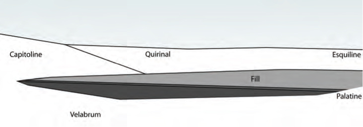
FIGURE 7
Schematic map of Rome with the Tiber in flood. Colored areas indicate known substantial activity dating before ca. 650 as well as cores exhibiting natural geography.
Between 650 and 600, Romans conceived and effected a vast geographical transformation in the Forum basin: a reclamation that would overcome this limitation.40 Study of the geography of the area has not only revealed the environmental restrictions on construction, but it has also introduced a new way of understanding remains of the earliest human activity there. Based on evidence Gjerstad found of wattle-and-daub huts, most archaeologists had understood the layers of activity just above the natural floor of the basin as evidence of habitation that dated from the eighth to seventh centuries. The new understanding of hydrology renders this impossible, and what is more, the study reveals that there were only a few tiny fragments of daub to attest the habitation Gjerstad had described. Such few traces could have ended up in the basin by many means, and in other excavations, such meager finds would not have stood up as proof of a community of huts. The evidence for habitation is therefore unconvincing, and with the existing hydrology, earth-based construction simply would not have been feasible.
The lowest layers of human activity in the Forum basin also present a conundrum, which Gjerstad overlooked: remains of ceramics from these levels reveal an unnaturally rapid accumulation of material. Where typically it takes decades—sometimes centuries—for vast amounts of dirt and debris to form thick archaeological strata, in the Forum valley, the lowest levels of human activity on the site were represented in thick bands that appeared on average to take just years—or even less—to accumulate. Moreover, little (if any) time seems to have passed between the formation of each layer. In short, either Romans were building and destroying their community in the valley with unusual speed and an implausible amount of debris and earth, or something else was going on. Ammerman suggests a landfill, purposefully deposited to raise the floor of the basin above the Tiber’s annual flood level.41 He has further argued that the fill material was probably excavated from the adjacent Velabrum and deposited in the Forum in a conscious effort both to access clay beds beneath the soil in the Velabrum and to manufacture more usable urban space in the Forum area. Wherever it came from, the accumulation of soil and debris in the Forum basin raised its floor to 8.6 meters above sea level. On top of the last layer of fill, workmen spread a compact level of earth and finally a thick layer of gravel with a surface at nine meters above sea level, creating the first pavement of the Forum plain and a space elevated above annual floods.
The proposed landfill has gained broad acceptance, and it is now the standard interpretation of the earliest activity in the Forum basin, repeated in most studies and excavation reports.42 The project fits within a broad trend throughout the Mediterranean during the seventh and sixth centuries for geographical transformations, including vast underground waterways and canalization projects from the Near East to Italy as well as terracing and fill work in nearly every region of the Mediterranean.43 Furthermore, immediately after the landfill was created in Rome, other, smaller projects of fill and reclamation were enacted, suggesting a comfort with the principle of topographical transformation; by 500, a second fill of ten to twenty thousand cubic meters was carved—this time from the Capitoline and Tiber riverbank—and dumped within the enormous twin temple platform at S. Omobono.
The reclamation would have transformed the image of the space. In the early seventh century, the land between the Palatine, Velia, and Capitoline was a concave, seasonally inundated basin with streams running through it, unfit for habitation; after the landfill, a flat space paved with a thick, dense layer of light-gray gravel lay at the base of the hills and was largely free of flooding (fig. 8). As Ammerman describes it, though, the project is still somewhat unclear, and its function, image, and historical significance could use some context.44 Moreover, two essential questions remain unanswered. First, at what location between the Forum area and Tiber did the fill end? Second, if runoff from hills and natural springs coursed through the valley before the landfill, how did builders manage the resulting stream during and after the project?
Cores in the Forum and the adjacent Velabrum valley reveal a sharp disparity between elevations in the two areas during the archaic period. Seven distinct layers of landfill elevated the Forum plain to nine meters above sea level, but a core immediately southwest of the later Basilica Julia and several others in the Velabrum exhibit no such archaic fill; rather, the Velabrum experienced a centuries-long natural accretion that only reached nine meters above sea level in the early to middle Republic.45 This is in contrast to the Forum’s sudden rise in elevation in the archaic period. Thus, after ca. 650–600, when Romans raised and paved the Forum area, the elevation of the valley between the later Basilica Julia and Tiber remained more than two meters below it.
Although this clarifies the extent of the fill, the drop beneath the Basilica Julia also presents a conundrum: the earthen deposit would not hold itself back. Not only would its edge have been subject to collapse beneath its own weight, but runoff from the hills and annual Tiber floods also would have inundated the freshly laid fill and unsettled it; when the Tiber receded, it would have pulled the loose earth out toward the river, eroding the fill. The destruction would have started almost immediately, and since the project would have taken several years (and the lowest levels of fill were far below the annual flood level), inundation during initial phases would have wiped away the buildup almost as soon as it was laid. To keep the newly deposited earth from eroding, the project’s planners must have constructed some kind of barrier from the start.
Imagining what this embankment looked like is a true exercise in hypothetical reconstruction, but with due caution, it is worth considering some possibilities. The only excavation carried out beneath the Basilica Julia was extremely small—at the lowest elevations, just a meter wide—and recovered very little.46 At about 9.5 meters above sea level, just level with the surface of the fill, archaeologists found three blocks of cappellaccio, which could belong to a retaining wall, but further investigation is necessary to confirm such scanty finds. Even if these blocks do pertain to an embankment, they reveal little of its overall design.
FIGURE 8
Schematic elevation of the Forum plain after ca. 625, as seen from the Palatine west slope, looking toward the fill.
To make any sense of the barrier’s potential design, one must look to the technologies employed for similar projects in the Mediterranean. All across the region, from contemporaneous cities in Assyria, Egypt, North Africa, Anatolia, Greece, and South Italy, there are examples of substantial landfill projects. Three examples may give a sense of the scale and similarities of projects dating to the seventh and sixth centuries. One is found at Selinunte, where city planners decided to expand their acropolis in the early sixth century. The site did not allow for this naturally, as there was a steep eastward slope to the acropolis, and so workers built a retaining wall to hold in earth and terrace a large portion of land for further construction.47 Another comparison lies at archaic Carthage, where it is possible that the byrsa (city citadel) was raised and terraced by human intervention; given the state of the site, however, the scale of the project is unknown.48 Perhaps the best comparanda are the massive land works and retaining structures near Argos. A late Geometric fill and retaining wall composed of large conglomerate limestone was found on the road from the Argive Heraion to Mycenae, and a second, much better-known monumental retaining wall at the Heraion itself was probably installed in the mid- to late seventh century, contemporaneously with the Roman endeavor, to hold back an earthen deposit for a massive terrace at the Old Sanctuary.49 The geographical circumstances at Argos are remarkably similar to the Roman situation and may give a sense of how Romans would have addressed the need to hold back a massive earthen plain (fig. 9). Similar polygonal and rubble masonry is known in communities throughout Central Italy by this time, so the technology certainly existed around Rome. Alternatively, if the cut stone in the Basilica Julia excavation pertains to the embankment, the wall may have been composed of ashlars. The evidence is indeed scanty, but the comparanda are numerous. In the end, what is most important is that such an embankment would have been necessary if the landfill were to work.
The discrepancy in elevation between the Forum and Velabrum also highlights drainage concerns during and after the project. A natural stream existed at the bottom of the Forum valley, and it would have been augmented by other streambeds (continuously or seasonally inundated) in the gullies between the Velia and Palatine and between the Arx and Capitolium.50 A canal would have been crucial to keep these from washing away the new fill. A free-flowing stream left to run through the newly raised space would have destabilized the fill, and, over time, it would have carved out a bed; as the waters descended to the river, they would meet with the edge of the fill, eventually spilling over, undermining its stability. At some point during or after the project’s completion, designers must have noticed this problem and built a canal. The most likely candidate for such a project is the Cloaca Maxima, which eventually became a sewer but probably began as a means to corral these streams. As it exists now between the Argiletum and the Temple of Castor, the Maxima is a mix of various reconstructions, the earliest of which appear to date to the mid- or late fifth century.51 Between the conclusion of the landfill ca. 600 and the construction of this stone canal, however, workmen must have put in another conduit.
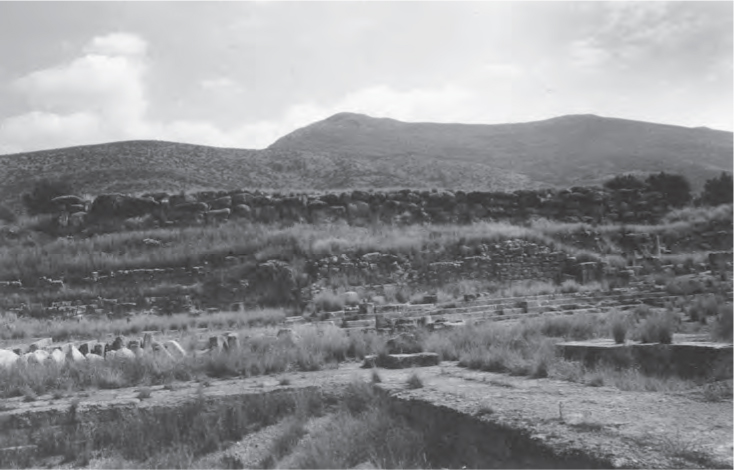
FIGURE 9
Argive Heraion, Old Temple terrace, late 7th century.
Like the embankment wall, its design is uncertain, and equal caution should be taken with any reconstruction based exclusively on comparanda; still, many canals exist in the Italic Peninsula from the period, and they may give some idea of what technology was available. In the seventh and sixth centuries, canals as large as 3.1 meters wide and 2.5 meters deep existed in Bologna, Casalecchio di Reno, Magreta, rural Modena, and Metaponto. These V- and U-shaped channels were dug into the ground and lined with clay and gravel.52 The clay acted as an impermeable barrier to keep water from seeping into the ground, and once dry, the clay and gravel acted together to hold back the earth on either side. The precise image of the Roman canal is presently unclear, but there is abundant and well-studied evidence that such projects were common throughout the peninsula; less certain is the path of the early watercourse in the Forum plain. The locations of the later stone Cloaca and the edge of the fill may provide some clues. It is unlikely that workers would position the canal through the center of the Forum fill, terminating it at the middle of the embankment; this would have left waters spilling down the wall and pooling at its base, unsettling its foundations. It is more likely that they directed waters to a corner of the wall, by the natural shoulders of the hills, and then channeled water down to the Tiber. Corresponding precisely to such a plan, the Cloaca Maxima runs in a seemingly circuitous path down the middle of the Argiletum, then diagonally across the Forum plain to the area beside the later Temple of Castor (just where the retaining wall would end), and then quickly down to the center of the Velabrum valley.
Even in its most basic reconstruction, for seventh-century Italy, the scope of the reclamation project is enormous. The fill covered a hundred-meter area between the Palatine and Capitoline and perhaps as much as 225 meters from the embankment wall to the Argiletum. The dimensions indicate over twenty-three thousand cubic meters of fill that workers had to harvest and transport to the Forum.53 Add to that a proposed two-meter-thick retaining wall and drainage system, and the undertaking becomes even more impressive.
As remarkable as the execution was, the outcome would have been just as astonishing. On approach to the city from the Tiber, a visitor or resident was greeted with the two-meter-high fill stretching between the Palatine and Capitoline. To ascend to the level of the new Forum plain, Romans appear to have flanked the fill with two roads, connecting the Forum area to the riverside. Archaeologists digging in the area of the Temple of Castor have found evidence that a roadway, later known as the Vicus Tuscus, already existed by the sixth century, just after the fill.54 A natural ramp also exists from the Tiber to the Capitoline. It led up to a gravel shoulder that connected the area behind S. Omobono to the later Temple of Saturn.55 This would become known as the Vicus Iugarius and seems to have already served as a roadway in the sixth century, complementing the Vicus Tuscus at the opposite end of the retaining wall. Both pathways had a natural inclination from the Tiber up the slopes of the Capitoline and Palatine hills and onto gravel shoulders that led to the edge of the Forum fill, providing access to the newly raised plain.56 Walking these pathways, a viewer met an artificial, paved, flat expanse stretching in front, with a freshwater stream running through it.
The project was vast. What is more, it had a profound impact on the composition of the hilltop communities. Even in its simplest image, the earthen fill created a new, artificial plain positioned in such a way that it connected the slopes of the Palatine, Capitoline, Velia, Esquiline, and Quirinal. This shifted topography may be a key to investigating the age-old questions of the chronology of settlement cohesion at Rome and the creation of a single urban landscape for a consolidated polity. The “proto-urban” movement had already created a sprawling, socially stratified community on the hilltops, but these communities could not fully cohere in a practical way until geographical separation was addressed. The landfill is the first archaeologically attested sign of a community that attended to these issues and sought to promote a single topographically connected polity. It is hard to imagine a solitary settlement on just one of the hills as being responsible for the reclamation of the Forum basin. Because its edge touched and changed the geography of each of the hills, the project would have affected them all, and at the very least, consent to enact it would have been crucial. And the scale of the project—the heavy labor and vast amounts of earth to be moved—suggests more than just consent; the need for a substantial workforce to create it would almost surely have required a unified effort.57
Of course, a joint effort does not necessarily signify the unmitigated cohesion of settlements into a complex city-state. It is possible that a communal endeavor by distinct groups might build collaboration for the common good, while stopping short of absolute unification. Still, in order to come together in such a way as to collaborate on a large, sustained project that would fundamentally change all of their topographies, the settlements could not have been too isolated in the previous years; distinct groups without a sense of their partners would hardly undertake the effort of such a huge, transformative venture.58 At any rate, whatever it might say about the unity of Rome prior to its inception, one should see the reclamation as an action that had a crucial effect on the eventual urbanization and unification of Rome. Once it was in place, it was unlikely that the hilltop communities would retreat to isolation. As a site extending between them, the Forum plain was by definition an intermediary space, a new geography that linked the hills. It extended to the edges of each settlement, and by virtue of its position, it engendered community.59 Thus, whatever its intended function, and whatever the circumstances of construction, the reclamation would shift the narrative of the formation of the city. As I discuss in the next chapter, in the wake of the reclamation, the manufacture of new civic monuments all around the plain suggests an almost immediate acceptance of its function as a unifying social space.
To be clear, this is not to say that the Forum reclamation defines the moment of urbanization—a single act that marked total change—but it does appear to be the first archaeological evidence of an unequivocal social and topographical change meant to promote unification of the hills around a central space. The shift would continue in the next century, and the next chapter will in part highlight how the slow move from proto-urban center to urban polity continued in a long and delicate gestation.
The newly raised Forum plain and its effect on the hilltop communities would transform the urban and architectural history of Rome to great benefit, but a question still remains: Why would Romans—or individual communities—come together to attempt such a burdensome endeavor? Economic growth in the late eighth and seventh centuries and the accompanying spread of settlements on the hills in the years preceding the project expose an expanding community and its need for more room to build; it may even indicate a desire to cohere as a city. Yet the need was for space to expand and perhaps space to assemble, not necessarily space in the Forum basin. There is no substantial evidence for a preexisting interest in civic cohesion around that particular area. In the early seventh century, a communal space at the later Comitium—on the Forum side of the Capitoline—may have been cleared for use, but the date of this activity is uncertain, and the first real construction there does not begin until after the reclamation project.60 The only site in the Forum basin that saw real use before the reclamation was the area of the later Atrium Vestae and Regia, on the Forum side of the Palatine. Yet another area at the opposite end of the Palatine, on the edge of the Colosseum valley, shows similar activity that continued after the fill, suggesting a broad expansion in all directions. The same is true of the Capitoline, where cult development at the site of S. Omobono demonstrates expansion down the western slope toward the Tiber, away from the Forum basin. Graves on the far northern plain of the Esquiline suggest expansion away from the Forum basin, and cult activity on the western Quirinal, overlooking the Campus Martius, is clear from ceremonial deposits dating to the early seventh century as well. The settlements on the hills were certainly growing, but evidence for expansion extends in many directions. Additionally, one must remember that without excavation down to the early levels of the Caelian, Aventine, and other hills, the perspective is somewhat skewed. Until just fifteen years ago, activity was unknown in the Colosseum valley and atop the Capitoline Hill in this early period. It would be unwise to presume that there were not even more civic spaces around the Colosseum valley by the Caelian, in the valley of the Circus Maximus, back in the basin between the Esquiline and Quirinal, or on the northern slopes of the Capitoline and Quirinal.
In short, the evidence that exists simply does not indicate that the Forum basin was a city center: certainly not the city center. In this early period, with such diffusion and fragmentary evidence, one must un-see the standard map of Rome, with the basin between the Forum and Tiber as the urban focus and the city situated all around that space. That map is anachronistic for this period. One must instead see many possible plans of the amorphous, unknown early city, and with these perspectives, the teleological view of the inevitable Forum cohesion becomes clear; there were many places to expand and cohere.
The insalubrious valley was by no means the most environmentally or economically practicable place to grow a community. In fact, there were other, potentially better options. The existence of settlements and burials on many of the larger hills suggests the suitability of the eastern plateaus: the spurs and tops of the Esquiline, Viminal, Oppian, and Quirinal to the east. The Esquiline is vast and would have provided outstanding space for new construction, as would the Quirinal. Their geologies and hydraulic situations are superior to the cavity between the Capitoline and Palatine or any of the valleys, and expansion onto the Esquiline would have maintained a centralized settlement between all the hills, if that were desired (see fig. 7). What is more, had those on the hills expanded into these areas, they would not have had to diverge from the pan-Mediterranean cultural norm of settlements focused on hilltops, and they would have saved enormous efforts that were exerted in the Forum reclamation.61 They also would have been free of floods and had wide spaces to build a growing community.
The city could have grown more easily and with good reason in many directions. In fact, it may have done so, given evidence from the Quirinal and Esquiline hills and from the Colosseum valley. Still, at this crucial moment, Romans did choose to fill the Forum basin. As a means for new space, perhaps in tandem with expansion to other areas of the city, they chose to add to their landscape with massive land reclamation. This was not a slow expansion into the dale; they did not wind up in the Forum, as the standard narrative suggests.62 They would have to fill the basin first. Given that it required such a drastic change to the geography of the city—a change that was incongruous with ubiquitous hilltop settlement patterns—and required such effort, this must have been a substantial and conscious decision.63 What, then, was their motivation? It must have been the Tiber. Rome was the first major inland community along its banks, and scholars have long seen this position as a fundamental reason for the city’s prominence. It is in the seventh century, just prior to the Forum reclamation, that foreign imports begin to increase in Rome and the city’s economy began to grow.64 Scholars see Tiber Island as a rare link between the east and west banks of the river and communities on either side; along with it, the purported construction of the Pons Sublicius in the seventh century and evidence at S. Omobono for subsequent trade in expensive and avant-garde foreign objects indicate Rome’s increasing connection to the river and exploitation of the riches and contacts that it brought past the city.65 To center the community on the eastern hills with no concern for the Tiber would have been to turn its back on a crucial and rapidly developing artery to Mediterranean trade and inland markets. The only way to allow for expansion and maintain a command of the river was to create an environment for continued construction that anchored the city to its banks. It was for this reason that Romans chose to reclaim the Forum basin, and in doing so, to generate a new geography and a purpose-built, unified landscape.
The calculated geographical transformation reveals a momentous shift in Roman civilization, not only because it was a vast communal effort, but also because it indicates a radical shift in resources. The project was perhaps the first truly monumental architectonic undertaking in Rome, and it is certainly the first for which archaeological evidence exists. As an act of human intervention in the natural world, the project reveals a deliberate transformation of the inherent landscape. Had it blended into the surrounding environment, it might have been forgotten, unimpressive, and utilitarian, but the distinction between the elevation of the Forum and the Velabrum would have been apparent. Furthermore, the next three chapters will reveal that Romans soon marked the space with monumental architecture and a stone pavement. It would have stood out to contemporary viewers, and these signifiers recorded that Romans had effected a change in their surroundings.
The change and its scale mark a critical shift in Roman civilization. Had people in Rome preferred, they could have expanded their community to the other hilltops without such effort, though they may not have been as connected to the Tiber. Strictly speaking, the reclamation and all the necessary labor were not essential to Rome’s survival; the project was undoubtedly desired and clearly advantageous, but not required for continued existence. This therefore reveals a critical moment in Roman history, when people were able to exert new efforts in creating monumental projects that transformed the image of their city in ways that were unnecessary, but functional and beneficial.
Two theories of monumental initiatives address the significance of this kind of excess, and they both suggest that projects like the Forum reclamation indicate a considerable cultural shift. Janet DeLaine argues that monumental structures have the power “to reshape the face of the earth, and thus to create a new landmark to rival those of nature.”66 Romans undoubtedly put a monumental stamp on their city with the landfill, rivaling the natural environment with an intervention into the inherent geography of their site. Bruce Trigger has argued that monumentality indicates a general human interest to assert power:
If economy of effort is the basic principle governing the production and distribution of those goods which are necessary to sustain human life, the ability to expend energy, especially in the form of other people’s labour, in non-utilitarian ways is the most basic and universally understood symbol of power. Monumental architecture and personal luxury goods become symbols of power because they are seen as embodiments of large amounts of human energy and hence symbolize the ability of those for whom they were made to control such energy to an unusual degree.67
Romans could have expanded their city elsewhere, but they chose to include a reclamation of the Forum basin in their efforts. The act signifies excess human labor and assets that are only available to communities with a certain amount of resources.68 What is perhaps more startling is that this was not the only such project. Similar, though smaller, fills were carried out along the north slope of the Palatine, around the area of the Vestal Virgins, and perhaps in the Colosseum valley just after the Forum reclamation.69 Thus, in its wake, it seems that land reclamation for the environmental improvement of the city’s topography was understood as an acceptable practice. Romans were beyond building for utility. As they opened up to trade and interaction along the Tiber, they saw the benefit in building on the potential that mercantilism allowed. With the advent of the Forum landfill, one can identify Romans breaking the barrier wherein necessity defines action, and in its wake, they began monumental projects around the plain and throughout the city that effectively proclaimed their new interests and wherewithal.