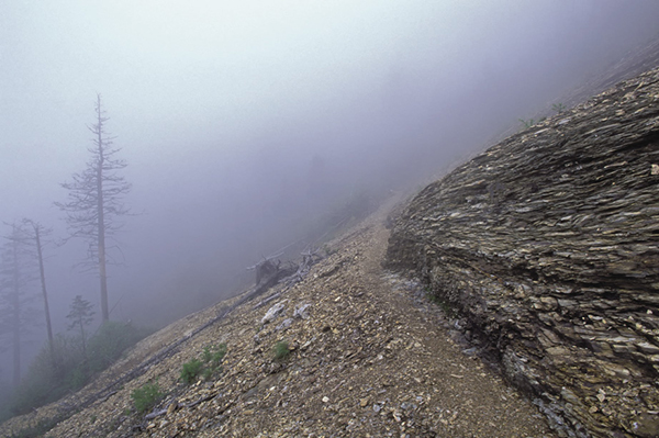
Fog enshrouds a landslide along The Boulevard Trail.
31 Mount LeConte via The Boulevard
If you have to choose only one hike in the Smokies, this would be a good choice. It gives you nearly everything the park is famous for, and by starting at an elevation of 5,046 feet and ending at close to 3,800 feet, it’s not overly strenuous. You’re going to get a good workout to be sure, but at least you won’t think you’re in boot camp. Before making this hike, be sure to read “Hiking to Mount LeConte” at the beginning of the Northeast section.
(See map for Hike 29: Alum Cave Bluffs.)
Start: Newfound Gap
Distance: 13.2 miles point to point
Hiking time: About 7 hours—day hike or overnighter
Difficulty: Strenuous
Trail surface: Forest trail with lots of rocks, some sections over solid rock
Other trail users: Hikers only
Maps: Clingmans Dome and Mount LeConte USGS quads; Trails Illustrated #229 Great Smoky Mountains; Trails Illustrated #317 Clingmans Dome Cataloochee
Special considerations: Some of the qualities that make this hike so appealing—precipitous drop-offs and paths carved out of solid rock—also make it very dangerous, especially with snow or ice on the trail. This is a hike for surefooted hikers wearing ankle-supporting hiking boots. Leave the sandals in the car. Only experienced and well-prepared hikers should attempt this hike in winter. You might start out at Newfound Gap in flurries, only to find yourself wading in a foot of snow on Mount LeConte.
If you wish to spend the night at LeConte Lodge on Mount LeConte’s summit, you’ll need to make reservations well ahead of time. The backcountry shelter on Mount LeConte also requires reservations, as do all other shelters in the park.
Other: Newfound Gap has a very large parking lot, but it can fill up on weekends or any day during the summer and autumn season. Restrooms are available here.
Finding the trailhead: The trailhead is located at Newfound Gap Overlook on the Smokies crest. Drive 15.5 miles north on Newfound Gap Road from Oconaluftee Visitor Center or 12.7 miles south from Sugarlands Visitor Center. The trailhead is on the northeast end of the parking lot, between the paved path leading to the restrooms and the Rockefeller Memorial. GPS: N35 36.669' / W83.25.495'
The Hike
Begin hiking the Appalachian Trail (AT) from the northeast corner of the parking area. The trail starts out level and wide, but you soon begin a 1.5-mile steady ascent to a grassy knoll. You’re walking through high-elevation spruce-fir forest, with occasional openings providing vistas of Mount LeConte to the north. In late April and early May, spring beauty and trout lily cover the ground.
From the knoll, descend 0.2 mile to a gap and the junction with Sweat Heifer Creek Trail at a huge, gnarled birch tree. The gap is a good spot for a breather. Walk a few hundred feet on Sweat Heifer Creek Trail to a grove of young American beech trees. Beech bark disease killed all the mature trees, and the trunks have now fallen, leaving an open view over the young trees. Although the view of a healthy mature beech forest would be much preferred, the lack of tall trees provides great views into the Oconaluftee River watershed.
Back on the AT, head east and begin a steep ascent. You soon pass an open view into North Carolina, taking in Clingmans Dome, Newfound Gap Road, and a glimpse of Bryson City. At 2.7 miles you reach the junction with The Boulevard Trail forking to the left (north). Leave the AT here and follow The Boulevard Trail about 0.1 mile to a side path on the right for the Jumpoff. There may be a sign here. It is at a wide spot in the trail created from an uprooted tree on the left. The path goes to the right and climbs the bank on rocks and roots. The rugged path leads about 0.5 mile to an overlook that provides a great view of Charlies Bunion. If planning to overnight on Mount LeConte, this side trip is highly recommended. If you’re doing this trip as a day hike, you may not want to take the extra time.
Fog enshrouds a landslide along The Boulevard Trail.
From the side path, The Boulevard Trail ascends a bit and then begins a long, fairly steep descent along the northwest flank of Mount Kephart, crossing over the upper reaches of Walker Camp Prong and finally reaching a narrow ridgeline. This is The Boulevard, and you follow it all the way to Mount LeConte. Along the ridge are occasional open views to the right (north) into the Porters Creek watershed and leafy peeks left (south) into the Walker Camp Prong watershed. At your feet Rugel’s ragwort, found only in the Smokies, grows abundantly along the trail in many places. Look for the foliage in spring and the nodding yellow flowers in summer.
At about 2.5 miles from the AT, you swing sharply around to the right over Anakeesta Ridge. Look down at your feet. That gray slatelike rock you’re standing on is the Anakeesta Formation. Its type and orientation are responsible for the incredible geologic features encountered along this hike. You can see how easily this rock might fracture and break apart. Later on this hike you’ll see the effects of such fracturing.
Descend from the ridgeline to the remnants of a small landslide and look back behind you to see the summit of Anakeesta Knob and Anakeesta Ridge extending from it. Now go on an undulating course and come to a sharp left swing around a ridge, with open views to the north. You’re now ascending the flanks of Myrtle Point and you pass massive cliffs with sand myrtle clinging in cracks.
At this point you must cross the remnants of a massive landslide. What a horrific sight this must have been while the landslide was occurring. You’ll see several more landslide scars on the remainder of the hike, but few places in the Smokies allow you to experience one of these scars as intimately as this one does. A steel cable helps with the footing on the path through the slide and is a necessity with ice or snow on the trail. Beyond the slide you make a sharp left turn and come to a very dangerous section of trail. Back at the slide, at least you could see the danger and act accordingly. Here, a thin veil of vegetation hides the sheer vertical drops created by landslides.
Soon the excitement and exhilaration of the hike turn to depression as you near LeConte’s highest peak, High Top, and pass through its graveyard of fir trees. Every mature tree is dead, with many still standing as ghostly skeletons, while others lie in a jumbled tangle like chopsticks. (See the sidebar for Hike 49 for a description of what’s going on.) In recent years many young fir trees have grown back and somewhat lessen the visual disturbance.
After passing through a thick growth of young fir trees, a side path to Myrtle Point cuts back to the left. (If you’re overnighting on LeConte, you’ll want to hike back out to Myrtle in the morning to view the sunrise.) Just beyond the side path, you cross the highest point on Mount LeConte at 6,593 feet and the second-highest point reached by maintained trail in the Smokies. Clingmans Dome, at 6,643 feet, is a mere 50 feet higher, but some people want Mount LeConte to be the highest mountain in the park. Look over to the left on High Top’s summit. That pile of rocks looks very out of place, doesn’t it? It’s a lighthearted attempt by some people to make Mount LeConte higher than Clingmans Dome. They have a long way to go.

The Boulevard Trail runs through a lush spruce-fir forest.
After topping out on High Top, you pass the best view so far, toward Newfound Gap and Clingmans Dome. The parking area where you began this hike is clearly visible behind Anakeesta Ridge. Shortly beyond the vista is Mount LeConte Backcountry Shelter, one of only three shelters not located near the AT (Kephart and Laurel Gap are the other two). Just beyond the shelter you pass a side path to Cliff Top on the left and then come to the three-way trail junction near LeConte Lodge. (Cliff Top is where you’ll watch the sunset if overnighting on LeConte.)
Trillium Gap Trail goes right (northeast) and Rainbows Falls Trail continues straight ahead. The Boulevard Trail officially ends here. The scattered collection of buildings making up LeConte Lodge lies just beyond the trail junction. Trillium Gap Trail takes you behind the lodge and to the spring. Rainbow Falls Trail, which continues this hike, brings you past the front of the lodge a short distance farther to the junction with Alum Cave Trail, on the left (west).
Alum Cave Trail starts out level, but that quickly changes as the trail swings around to the east and skirts beneath the sheer cliffs of Cliff Top. Steel cables serve as helpful handholds with the wet rocks and are crucial when there’s ice on the trail. The 2.5 miles of descent between here and Alum Cave Bluffs are steep and rocky, with several stretches of trail carved out of solid rock. Along the way are a number of landslide scars and several good views. At one point along this stretch, you come to an ingenious solution to navigating a steep, rocky slope. The trail engineers angled a large, long tree trunk down the slope and sawed steps into it. Tar and gravel give traction to the steps. Farther down, the trail actually ascends a bit, and where it swings to the left and begins descending again, a side path leads a few feet to a view point known as Gracies Pulpit, which gives a somewhat open view of Mount LeConte.
From Gracies Pulpit, the trail descends a rock slope very steeply and soon comes to Alum Cave Bluffs. Walk under the bluffs and continue descending. At 0.9 mile from the bluffs, you hike through Arch Rock. It’s not an arch like those in Arches National Park or those in the valley and ridge provinces of Tennessee and Kentucky. In simplistic terms, those arches were formed by erosion from running water. Here, in the Anakeesta Formation, holes in the rock are caused by the expansion and crumbling resulting from millions of years of freezing and thawing.
After passing through Arch Rock, you cross Styx Branch on a footbridge and have an easy 1.4-mile walk to Alum Cave trailhead. Along the way you make several creek crossings, first of Styx Branch and then Alum Cave Creek, and you pass through a scenic old-growth forest. Some of the old hemlock trees in this section are still alive as of early 2012. (See the sidebar for Hike 36.)
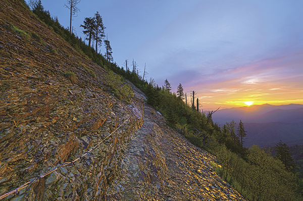
Sunrise illuminates a landslide along The Boulevard Trail. Steel cables provide handholds in icy conditions.
Miles and Directions
0.0Start on the AT on the northeast end of the parking lot.
1.7Sweat Heifer Creek Trail comes in from the right. Continue heading east on the AT.
2.7Bear to the left (north) on The Boulevard Trail.
2.8A side path on the right leads 0.5 mile to the Jumpoff.
7.6Just before the highest point on Mount LeConte’s summit, a side path on the left leads to Myrtle Point.
7.9Arrive at Mount LeConte Backcountry Shelter.
8.1Junction with Trillium Gap Trail and Rainbow Falls Trail. LeConte Lodge is immediately beyond the junction. Continue straight ahead on Rainbow Falls Trail.
8.2Turn left (west) on Alum Cave Trail.
10.9Pass under Alum Cave Bluffs.
11.8Hike though Arch Rock.
13.2Arrive at Alum Cave trailhead.