Trip 59
SYKES & REDWOOD CAMPS
LENGTH AND TYPE: 23.8-mile out-and-back
RATING: Moderate to strenuous
TRAIL CONDITION: Well maintained to clear, poison oak
HIGHLIGHTS: Stroll the free-flowing Big Sur past sheltered swimming holes, mineral-rich hot springs, and redwood forests to these idyllic camps.
TO REACH THE TRAILHEAD: At Big Sur Station the Pine Ridge Trailhead is at the end of the parking lot beyond the visitor center. Self-pay parking is $4/night for overnight guests. You’ll find water, flush toilets, and maps at the visitor center.
TRIP SUMMARY: Winding deep into the heart of the Big Sur River drainage, the lower Pine Ridge Trail from Big Sur Station to Sykes Camp is the most popular route into the Ventana Wilderness. The total elevation gain and loss along this stretch are 2380 feet and 1490 feet, respectively. The well-maintained trail winds past three other camps in the 10 miles to Sykes Camp. Expect plenty of foot traffic in summer, while spring break brings hordes of hikers to Sykes to cluster about the 100°F hot springs, which can get crowded and, at times, rowdy.
Despite the crowds, pesky flies, and mosquitoes, summer is the best time to visit for a brisk swim (mid- to high 50s Fahrenheit) or to lounge atop the Big Sur’s sunny banks and boulders. Swimming is also tolerable on warmer spring and fall days. In spring wild irises emerge from the damp forest floor, while lupines, poppies, hound’s-tongues, and starflowers bloom in natural riverside bouquets, highlighted by the occasional delicate tiger lily. Temperatures remain pleasant in fall, as breezes scatter colorful autumn leaves across the canyon floor. From winter through early summer, ticks thrive amid the trailside brush. Fortunately, vegetation rarely encroaches on this well-maintained trail. If you crave solitude, hike the trail in winter. Be aware, however, that the river can rise swiftly during winter storms, making crossings deep and treacherous. The only ford along this trail is at Sykes Camp, and you can avoid this crossing to reach the hot springs.
From Sykes Camp, the Pine Ridge Trail leads 2.4 miles east to Redwood Camp, where you’ll find peace beneath the trees even in busy summer months.
Trip Description
See TRIP 58 Ventana Camp for the first 3.9 miles of this route to the Ventana Camp Trail junction (1500').
From this junction, the Pine Ridge Trail ascends 70 feet and descends 260 feet over the next 1.4 miles to Terrace Creek Camp. Ventana (Spanish for window) holds true to its name along this trail, which offers framed glimpses down the Big Sur drainage to the sheer peaks and ridges of the Ventana Wilderness and distant Pacific. Notched and barren Ventana Double Cone lords over the northeastern skyline. Legends claim a rock bridge once connected its twin peaks, framing a window-like summit nearly 5000 feet above the ocean. Whether or not that’s true, the double summit served as a prominent landmark for Spanish vessels in the late 18th and 19th centuries.
Enjoy the views, as the trail soon enters shady gullies laced with ferns and moss-covered boulders amid seasonal springs. After a brief climb to a nearby ridge, you’ll descend south into steep, redwood-lined Terrace Creek canyon. Here you’ll find Terrace Creek Camp and the Terrace Creek Trail junction (5.3 miles, 1320').
The small camp flanks the creek just upstream from the junction. Don’t expect solitude, as hikers stream past en route to Sykes Camp or back to Big Sur Station. You’ll find one large main site for up to three tents along the east bank a few yards from the junction, just below a pit toilet. Three smaller sites lie upstream, two downstream. The steep canyon remains cool even in summer heat. In spring, carpets of redwood sorrel, mats of ferns and mosses, and delicate fairy bells line the babbling creek to its confluence with the Big Sur. If you’re bound for Coast Ridge Road via the Terrace Creek Trail, see TRIP 60 Highway 1 to Terrace Creek Camp for the trail description.
Beyond the signed camp junction, the Pine Ridge Trail ascends 510 feet and descends 210 feet in the next 1.4 miles to Barlow Flat Camp (see side trip). You’ll skirt a ridge and head east along its marble slopes to two seasonal springs. Past the second spring, the trail enters a damp redwood glen. Microclimates vary dramatically as the trail climbs to more arid slopes and sun-drenched ridges. Across the canyon, sheer granite walls reflect the sound of roaring rapids far below in the steep canyon.
Past a second ridge, the trail switchbacks and descends into Logwood Creek canyon (6.5 miles, 970'). The creek is an easy boulder-hop in all but the wettest months. After crossing, you’ll ascend 0.1 mile to a saddle, from which a short, steep spur climbs 200 feet in 0.1 mile to a 1290-foot summit. Detour here for far-reaching views south along the canyon. Past the spur, the trail descends 0.1 mile to the signed Barlow Flat Camp Trail junction (6.7 miles, 1040').
Beyond the signed camp junction, the Pine Ridge Trail ascends 900 feet and descends 690 feet in the next 2.9 miles to Sykes Camp. The trail starts out on a moderate 500-foot climb past a wall of fragile ferns, fed in wet season by a 40-foot waterfall above the trail. You may miss it entirely in summer. You’ll climb through two increasingly larger redwood gullies and emerge amid arid slopes cloaked with fragile wild iris beneath oaks, madrones, and a few pine saplings. As you crest a minor ridge (8.2 miles, 1640'), the vegetation changes to a chaparral community of chamise, ceanothus, and poison oak.
SIDE TRIP
The Barlow Flat Camp Trail descends steep switchbacks 150 feet in 0.2 mile to the outskirts of Barlow Flat Camp (6.9 miles, 890'). This is the most spacious camp along the Pine Ridge Trail, often welcoming large groups in summer. The first three sites sit atop a flat, redwood-shaded bench above the south bank of the Big Sur. Three more open sites are nestled amid fragrant bays, maples, alders, and sycamores closer to the water’s edge. Five more sites lie beneath redwoods, tanoaks, and peeling madrones along the north bank. The crossing is often wet until summer and may be impassable during or after heavy winter rains. A narrow trail leads upstream past the fifth site to an 80-foot-long swimming hole and sandy beach.
The swimming opportunities at Barlow Flat are excellent. Its sun-drenched rocky outcrops are perfect for basking in the sun and diving into some of the deeper pools. Expect water temps in the low 50s Fahrenheit in spring and fall and the low 60s on warm summer days. Temps may rise 10°F on a hot summer day.
A cross-country route leads to more alluring swimming holes downstream, though passage can be treacherous in rainy season. The first pool is adjacent to the site farthest downstream along the south bank. Onward, 150 yards downstream, cascades plunge through the narrow gorge into deep, hidden pools. From late spring through fall, it’s best to wade rather than scale the sheer canyon walls. Don’t even attempt passage in winter, as the frigid river can be swift and dangerous. Beyond an Olympic-sized pool, a gossamer 80-foot fall plunges from a small tributary into the Big Sur. If you’re willing to swim and wade a minute farther downstream, you’ll reach another emerald pool.
Beyond this exposed ridge, you’ll descend 200 feet to a cool, damp redwood gully cloaked with six-fingered ferns, which bear delicate palmate fronds. Beyond the gully, the route contours 0.2 mile along Dolores Creek canyon to a small knoll and dips directly above hidden Sykes Hot Springs. You’ll continue your descent southeast, switchback northwest, then descend 150 feet to the Big Sur. The trail emerges at Sykes Camp and the Sykes Hot Springs Trail junction (9.6 miles, 1080').
Most hikers end their trek at Sykes, as the Pine Ridge Trail ascends 1760 feet and descends 1130 feet in the next 2.3 miles to Redwood Camp. This less-traveled stretch is predictably ill maintained. Encroaching brush poses a nuisance in wet season when hitchhiking ticks are abundant.
SIDE TRIP
Sprawled along a 0.1-mile stretch of the Big Sur, Sykes Camp offers campers their choice of 10 sites. The best lie upstream from the Pine Ridge Trail.
From the trail junction, cross the river and head upstream to a sandy beach and adjacent emerald pool. This wet ford can be swift and treacherous in winter as the river swells. You’ll soon reach the first of six sites, with room for up to two tents beneath live oaks and madrones. Fifty feet farther upstream, you’ll reach a pit toilet amid three large redwoods. The second and third sites lie nearby along a narrow gravel bench. Each can accommodate up to three tents.
A larger fourth site is perched above the rocky bank in the shade of fragrant bays, madrones, and live oaks, whose roots grasp riverside boulders. Secluded pools below this site are often less crowded than pools closer to the hot springs. Perch atop the sun-baked boulders and watch small trout dart between the white water cascades and calm pools.
Beyond the fourth site, the camp trail leads 60 feet upstream, crosses the river, and emerges on a sandy beach beside another attractive pool. Just above this pool lies the fifth site, which can accommodate up to two tents. Onward, 80 feet past a bend, is the similarly small sixth site, atop a sandy flat bordered by a smooth rock face and alders.
Downstream, the unmarked 0.4-mile spur to Sykes Hot Springs is heavily used and easy to follow—ignore erroneous descriptions of bushwhacking from camp. Those who want to keep their feet dry will have to navigate sheer rock faces laced with poison oak. The preferred route requires a few boulder-hops or wades that may be difficult or impassable in rainy season.
From where the Pine Ridge Trail crosses the Big Sur, head downstream along the south bank 25 feet to the first crossing. Onward, you’ll pass a small single-tent site, recross the river, and reach two more sites, equipped with a pit toilet. Beyond the third site, the trail crosses the river twice in 100 feet and arrives at a fourth site. A third of a mile downstream, you’ll catch a whiff of sulfur from the first of several small hot seeps.
The trail ascends 60 feet to the first of three small pools, each large enough for up to four adults. Directly below the pool lies a stone- and sandbag-lined hot tub, 6 feet across and 2 to 3 feet deep. Perched beside the clear, bracing waters of the Big Sur, these mineral-rich 100°F pools are among Ventana’s most popular destinations. Don’t expect a private soak in summer or on weekends and holidays in spring and fall.
From Sykes Camp, you’ll cross the Big Sur and climb 0.3 mile to a long, narrow saddle. Passing a rocky ledge, the trail crosses a gully and small seasonal creek. Leaving the canyon, switchbacks climb to a south-trending ridge (10.6 miles, 1680'), offering impressive views down the Big Sur’s steep North Fork and South Fork drainages. The terrain and temperatures vary widely as the brushy route leads to a second exposed ridge, ducks through a small redwood-fringed gully, then returns to the dry slopes of chamise, manzanita, scrub oak, live oak, black sage, and scattered pines and yuccas. Just as suddenly, you’ll reenter shady groves along Redwood Creek.
Descending 0.1 mile, you’ll reach an unmarked spur on the right (11.9 miles, 1780') to Redwood Camp’s larger sites. If you miss this narrow spur, just continue 150 yards farther past two small sites and cross the river. The larger sites now lie a minute downstream.
The first site on the east bank sits amid large boulders and old-growth redwoods. Seventy feet downstream past a small seep, the trail leads to the biggest site, which can accommodate up to 10 tents. This site is perched atop a flat bench carpeted in wild strawberries, starflowers and sorrel in the shade of redwoods, tanoaks, and madrones.
If you continue eastbound on the Pine Ridge Trail, expect conditions to worsen. Overgrown brush, loose tread, and exposed slopes make the 2770-foot climb over the next 3.9 miles to Pine Ridge a strenuous adventure.
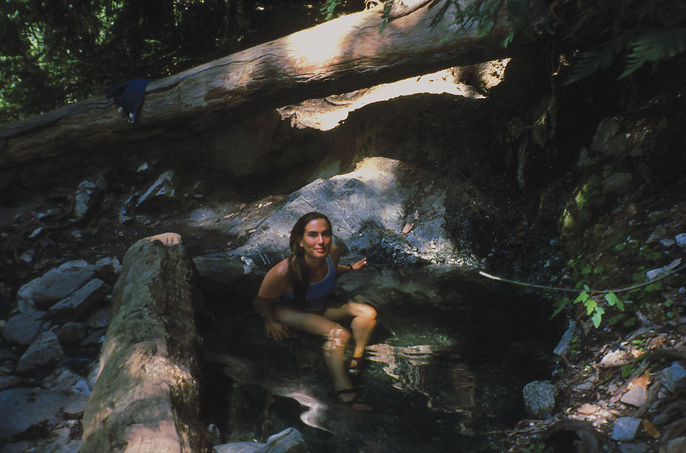
Sykes Hot Springs is one of Big Sur's most popular backcountry destinations.
From Pine Ridge, the Black Cone Trail leads into the heart of the wilderness, skirting some of Ventana’s highest peaks and ridges (see TRIP 53 Black Cone Trail to Arroyo Seco). If you intend to hike the entire 23.1 miles of the Pine Ridge Trail, Redwood Camp is an excellent place to rest before beginning the long climb. Better yet, start your hike from China Camp to avoid excessive elevation gain (see TRIP 52 Pine Ridge, Sykes Hot Springs, & Big Sur).