Wapama Falls
Most everybody in California has visited Yosemite Valley at one time or another, but substantially fewer people have visited Hetch Hetchy Valley, Yosemite’s “twin” in the northern section of the park.
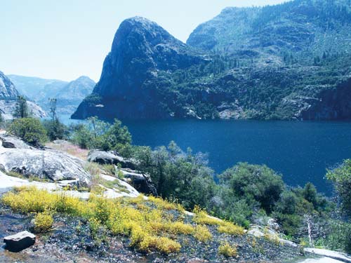
Hetch Hetchy Valley was flooded in 1923 to create a water supply for San Francisco. It was the tragic end of a long fight by naturalist John Muir, who tried in vain to save Hetch Hetchy from the big-city politicians. Muir described Hetch Hetchy Valley as Yosemite Valley’s “wonderfully exact counterpart.” Although smaller in size, Hetch Hetchy was shaped by the same geological forces that created Yosemite’s glacially carved valley. When people see pictures of what Hetch Hetchy looked like before it was dammed and flooded to provide water for San Francisco, they are struck by how much it resembles today’s Yosemite Valley. Photos show the stark, pristine granite of Kolana Rock and Hetch Hetchy Dome jutting upward from the valley floor, waterfalls dropping hundreds of feet from hanging valleys like rivers falling from the sky, and lush, flower-filled meadows lining the edge of the meandering Tuolumne River. You can’t help but wonder, what on earth were those politicians thinking?
But here’s the reality of the situation: Despite humans’ best efforts to destroy it, Hetch Hetchy remains beautiful. Without question, the valley has lost an irreplaceable amount of its original splendor. But when you hike along the shoreline of 360-foot-deep Hetch Hetchy Reservoir and observe the higher sections of granite and waterfalls that tower imposingly above the waterline, you get the sense that Nature has ceased crying over Hetch Hetchy. Instead, she has done what she does best—heal, beautify, and make the most of what is here now. Wildflowers blossom in the understory of massive ponderosa pines and incense-cedars. Birds and other wildlife make their homes along the edges of the deep blue reservoir. Hetch Hetchy’s waterfalls still flow with exuberance, and its granite towers still stand guard over the valley.
Look for S to find recommended sights, activities, dining, and lodging.
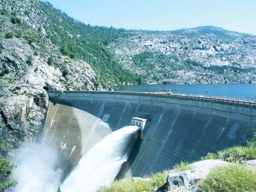
S O’Shaughnessy Dam: A remarkable feat of engineering, the 312-foot-high dam that forms Hetch Hetchy Reservoir took almost seven years to build. It was another 14 years until the infrastructure was completed to carry Hetch Hetchy’s water to San Francisco, a distance of 156 miles. See the dam in spring when its overflow valves are spraying thousands of gallons of water into the free-flowing stretch of the Tuolumne River (click here).
S Tueeulala and Wapama Falls: In spring and early summer, these two spectacular waterfalls drop more than 1,000 feet to the lakeshore at Hetch Hetchy. At full flow, both falls are visible from O’Shaughnessy Dam, but to see them up close, take a 4.8-mile round-trip hike along the reservoir’s northern edge and enjoy a fabulous wildflower display along the way (click here).
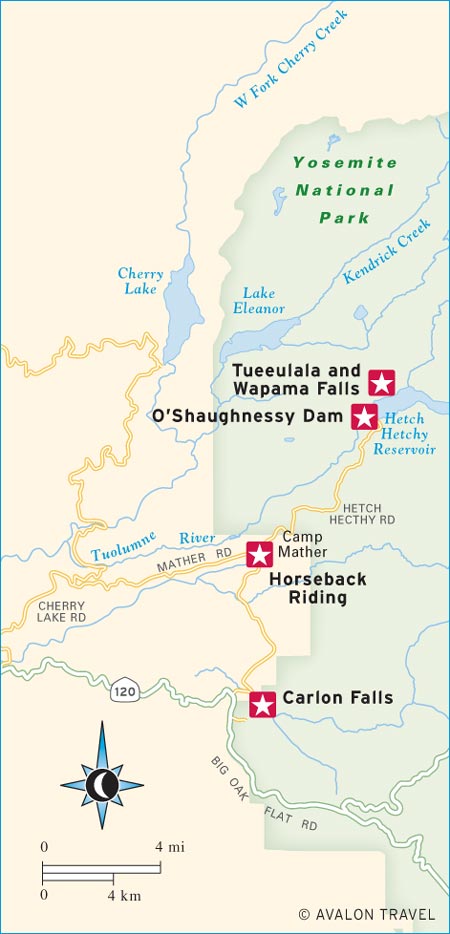
S Carlon Falls: A favorite swimming hole for more than 100 years, the pools below Carlon Falls make a fine destination for a short hike on a hot summer day. Plenty of people never make it as far as the falls; they just pick an inviting spot along the river near the trail’s start at Carlon Day Use Area (click here).
S Horseback Riding: Ride off into the sunset on a trusty steed from Mather Saddle and Pack Station, enjoying end-of-the-day views of the Grand Canyon of the Tuolumne River. Or start off the day right with their Cowboy Breakfast Ride, a one-hour excursion followed by an al fresco meal fit for a hardworking ranch hand: scrambled eggs, bacon, fried potatoes, cowboy coffee, and biscuits cooked over an open fire (click here).

Hetch Hetchy is best visited in spring, when its waterfalls are flowing at their fullest and temperatures are still mild and cool. April and May are the prime months here, not only for waterfall watching but also for wildflower viewing. Summer can be quite hot, with temperatures frequently reaching 90°F to 100°F. The valley’s waterfalls run dry by midsummer. Autumn is another good time to visit Hetch Hetchy, when temperatures drop to a more comfortable level and the region’s deciduous trees put on a lovely fall color show. Snowfall will sometimes, but not often, close the road to Hetch Hetchy in the winter.
Of the five park entrance stations, Hetch Hetchy sees the fewest number of cars passing through day after day. Armchair visitors can take a virtual tour of Hetch Hetchy at www.sfwater.org. Casual day-trip visitors can make the winding, 18-mile drive to Hetch Hetchy from Big Oak Flat, walk along the top of O’Shaughnessy Dam, read the series of interpretive signs that explain the reservoir’s history, and get a good look at the area’s cliffs and waterfalls. Those who are in the mood for a short, level hike can walk the path to the base of impressive Wapama Fall. A longer day hike or a backpacking trip can be made to the far end of the reservoir and Rancheria Falls, or to many other worthwhile destinations in this remote region of Yosemite.
There are no visitors centers in this region of Yosemite, but the ranger at the Mather Ranger Station will happily answer any questions.
The small Hetch Hetchy entrance station lies nine miles north of Highway 120 via Evergreen Road and Hetch Hetchy Road. These two roads are sometimes closed in winter. Because the roads are narrow and winding, vehicles longer than 25 feet or wider than 8 feet are prohibited at all times. It’s best to prepare for a trip to Hetch Hetchy by having everything you might need or want already in your car. Opportunities for food and supplies are limited once you leave Highway 120. Also, note that unlike other roads in the park, the Hetch Hetchy Road is not open 24 hours a day. You can drive the road from 7am to 9pm daily from May 1 through Labor Day (reduced hours the rest of the year, depending on daylight hours).
Hetch Hetchy Reservoir is a 40-mile drive from Yosemite Valley via Highway 120 and the Evergreen and Hetch Hetchy Roads. Plan on about 75 minutes to make the drive in good weather. Starting from the Big Oak Flat entrance to Yosemite, head west on Highway 120 for one mile and then turn right on Evergreen Road (road may be closed in winter). Seven miles down this road is the Evergreen Lodge, a cabin resort with a good restaurant and store. A half mile farther is Camp Mather, a camp run by the city of San Francisco. Bear right on Hetch Hetchy Road (road open 7am-9pm daily May-Labor Day, may be closed in winter) at Camp Mather, and in 1.5 miles you will pass through the Hetch Hetchy entrance station to Yosemite. Get any information you might need here; this is probably your last chance to see a park ranger.
Hetch Hetchy Road continues for another 7.5 winding miles to O’Shaughnessy Dam. This road was the route of the Hetch Hetchy Railroad, which carried men, machinery, and materials to the dam’s construction site. At several points in the road you will gain some long-distance peeks at the reservoir and its waterfalls. Park at the dam and take a closer look at what humans, and Mother Nature, have created in Hetch Hetchy Valley.
Built by the City of San Francisco during the years from 1914 to 1923 to provide power and water for its citizens, O’Shaughnessy Dam was a product of its time. Although the dam’s construction was adamantly opposed by John Muir, the Sierra Club, Pacific Gas and Electric Company, and the cities of Turlock and Modesto—all for their own reasons—the dam came into existence because of a piece of Congressional legislation called the Raker Act, signed into law by President Woodrow Wilson. (Although some progressives claimed this was a noble victory because it would mandate the breakup of Pacific Gas and Electric Company’s San Francisco energy monopoly by creating a municipal, public power source, this never came to fruition.) The prevailing political mood at the time, particularly at the federal level, could not allow the preservation of a national park to be more important than the twin themes of progress and development. And so the massive dam was built, Hetch Hetchy Valley was flooded, and the world will never again see the twin to Yosemite Valley in its pristine state.
O’Shaughnessy Dam
Whatever else we may think or say about it, the dam is a remarkable feat of engineering. It took almost 7 years to build, and another 14 years before the aqueduct lines were completed over the 156-mile course to San Francisco, which required building 37 miles of tunnels. The system operates entirely by gravity. The original cost of construction was more than $12 million—a fortune at the time. When the reservoir’s water finally flowed to San Francisco, the cost had risen to $100 million. But the building didn’t stop. In 1938, the original dam was modified, which raised its height by 85 feet. Currently, the dam can hold back approximately 117 billion gallons of water. The reservoir is eight miles long and 306 feet deep at its deepest point.
O’Shaughnessy Dam is located 7.5 miles north of the entrance station on Hetch Hetchy Road. After parking at the dam, be sure to walk across its massive, 600-foot-long concrete surface.
In the spring and early summer months, two waterfalls are visible from O’Shaughnessy Dam: Tueeulala and Wapama Falls. Both falls drop about 1,000 feet before they hit the waterline of Hetch Hetchy Reservoir, which means they were nearly 1,800 feet high before the great manmade flood. By July, wispy Tueeulala Fall usually runs dry, but Wapama keeps a fair flow going into August. In spring, Wapama Fall sometimes runs with such force that the National Park Service is forced to close the trail below it. A 4.8-mile round-trip hike leads from the dam to the falls.
At press time, the road to Cherry Lake was closed due to devastation from the Rim Fire, affecting hikes to Lake Eleanor and Preston Falls. Contact the Groveland Ranger District (209/962-7825) for an update on trail reopenings in this area.
Distance: 2.8 miles round-trip
Duration: 1.5 hours
Elevation Change: 600 feet
Effort: Easy
Trailhead: Mather Ranger Station (see map click here)
Directions: From Groveland, drive east on Highway 120 for 22.5 miles to the Evergreen Road turnoff (one mile west of the Big Oak Flat entrance to Yosemite). Drive north on Evergreen Road for 7.4 miles and turn right on Hetch Hetchy Road. Drive 1.5 miles to the entrance kiosk near the Mather Ranger Station; the trail begins 100 yards past the entrance kiosk, just beyond the ranger station on the right.
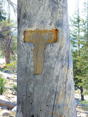
Trail markers on trees help you find the trail.
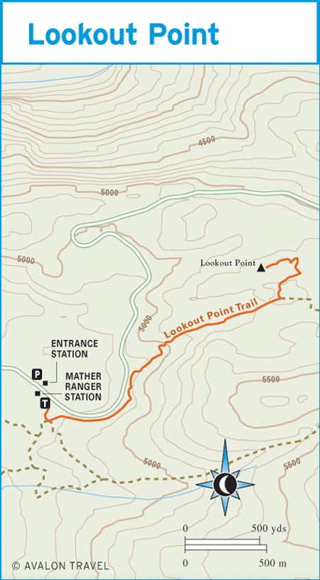
Check your calendar. Is it springtime? Are most of the high-country trails in Yosemite National Park still snowed in? Then it’s time to take the easy jaunt to Lookout Point, where you can admire Hetch Hetchy Reservoir and its waterfalls from an unusual perspective and count the plentiful wildflowers along the trail as you walk. The Lookout Point Trail begins near the Mather Ranger Station on Hetch Hetchy Road. Begin hiking at the trail sign for Cottonwood and Smith Meadows. Turn left at the first junction; then follow the trail as it roughly parallels Hetch Hetchy Road for 0.5 mile. The trail turns away from the road with a brief uphill stretch and then enters a level, forested area that was severely burned in the wildfires of 1996. This is where the flowers bloom profusely in springtime. Look for a trail junction at 1 mile out, and bear left for Lookout Point, 0.3 mile away. The path gets rather faint in places, but rock cairns mark the way. Just head for the highest point you see atop a granite knob dotted with a few pines. You’ll know you’re at Lookout Point when you can see the west end of Hetch Hetchy Reservoir (including its immense dam) and two of Hetch Hetchy’s beautiful waterfalls: Wapama and Tueeulala. If you visit much later than May or June, you may see only Wapama, the most robust of Hetch Hetchy’s waterfalls. Tueeulala dries up early in the year. Although the vista is not perfect from Lookout Point—it would be better if it were 500 feet higher or if there weren’t so many trees—this is still a fine spot to spread out a picnic. You probably won’t have any company, either.
Distance: 13 miles round-trip
Duration: 6 hours
Elevation Change: 3,700 feet
Effort: Very strenuous
Trailhead: Smith Peak (see map click here)
Directions: From Groveland, drive east on Highway 120 for 22.5 miles to the Evergreen Road turnoff, signed for Hetch Hetchy Reservoir (one mile west of the Big Oak Flat entrance to Yosemite). Drive north on Evergreen Road for 7.4 miles and turn right on Hetch Hetchy Road. Drive 1.5 miles to the entrance kiosk by the Mather Ranger Station; then continue 6 miles to the Smith Peak trailhead on the right side of the road.
A steep and challenging 13-mile round-trip hike will earn you the summit of 7,751-foot Smith Peak, the highest pinnacle in the Hetch Hetchy area. The peak and part of its trail were hit hard by the Rim Fire of August 2013, so this is an interesting place where hikers can view the process of regrowth after a fire. It will be many years before this region recovers completely, but green undergrowth has already sprouted from the ground. The summit’s panoramic view of Hetch Hetchy Reservoir and the Grand Canyon of the Tuolumne River is still as awesome as it ever was.
Smith Peak can be accessed from several trailheads, but the shortest trip—still a prodigious 13 miles—begins at the Smith Peak Trailhead located on Hetch Hetchy Road. From the road, the trail climbs upward along Cottonwood Creek to Cottonwood Meadow and then Smith Meadow beyond (both can be very wet and boggy until mid-June). Beyond Smith Meadow you’ll see the most intense fire devastation; the final 1.5 miles to the summit were completely torched. The peak is covered with pockmarked granite boulders, and its wide summit vista of Hetch Hetchy Reservoir, 4,000 feet below, as well as the Cathedral and Clark Ranges to the north and east, offers a fine reward for the climb.
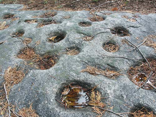
Native American grinding holes along the trail to Smith Peak
Distance: 4.8 miles round-trip
Duration: 2.5-3 hours
Elevation Change: 350 feet
Effort: Easy
Trailhead: O’Shaughnessy Dam (see map click here)
Directions: From Groveland, drive east on Highway 120 for 22.5 miles to the Evergreen Road turnoff, signed for Hetch Hetchy Reservoir (one mile west of the Big Oak Flat entrance to Yosemite). Drive north on Evergreen Road for 7.4 miles and turn right on Hetch Hetchy Road. Drive nine miles to the dam and trailhead.
The trail to this spectacular early-season waterfall starts by crossing the giant O’Shaughnessy Dam, where you may pause to curse the San Francisco politicians who believed that flooding Hetch Hetchy Valley was a good idea. If this is your first trip to this part of Yosemite, be sure to stop at the dam and read the interpretive plaques that explain the building of Hetch Hetchy Reservoir and its service to San Francisco. After passing through a lighted, 500-foot-long tunnel, the trail opens out to a mixed forest along the edge of the deep blue lake. Wildflower displays are often excellent in late spring. In 1.5 miles you reach Tueeulala Fall, a delicate wisp of a freefall that only runs during peak snowmelt and is often dry by late May. Less than a mile farther you reach powerful Wapama Fall on Falls Creek, a Bridalveil-like plume of white water that makes a dramatic plunge into the reservoir. Depending on how early in the year you visit, you may get soaking wet standing on the sturdy steel bridges that cross over Wapama Fall’s coursing flow. In early spring, Wapama Fall sometimes flows so furiously that the park rangers have to close this trail.

Distance: 4 miles round-trip
Duration: 2 hours
Elevation Change: 350 feet
Effort: Easy
Trailhead: Carlon Day Use Area (see map click here)
Directions: From Groveland, drive east on Highway 120 for 22.5 miles to the Evergreen Road turnoff, signed for Hetch Hetchy Reservoir (one mile west of the Big Oak Flat entrance to Yosemite). Drive north on Evergreen Road for one mile to the far side of the bridge, just past Carlon Day Use Area. Park in the pullout on the right. Begin hiking on the closed-off road, heading upstream.
Carlon Falls is not located in Hetch Hetchy Valley; its trailhead is found on the road to Hetch Hetchy (Evergreen Rd.). This means it gets missed not just by the large number of Yosemite visitors who never see Hetch Hetchy, but also by visitors who are heading so intently to Hetch Hetchy that they ignore everything along the way. This waterfall on the South Fork of the Tuolumne River shouldn’t be passed by. It has two big factors going for it: (1) It’s accessible by an easy, nearly level, pleasant hike; and (2) it’s a river waterfall, so it has a dependable amount of flow even in autumn, when Hetch Hetchy’s and Yosemite’s waterfalls have all but gone dry.

Follow the obvious trail on the north side of the river from Carlon Day Use Area (the trail on the south side is an unmaintained anglers’ route). Although you begin your hike in Stanislaus National Forest, you will soon walk into Yosemite National Park. The trail passes through an impressive old-growth pine and fir forest, highlighted by wildflowers in the spring and colorful oak and dogwood leaves in the autumn. After two miles of riverside meandering, you’ll reach 30-foot Carlon Falls, a lacy cascade that drops over a granite ledge in the river. The rocks below it make a fine picnic spot. The waterfall’s namesakes are Dan and Donna Carlon, who operated the popular Carl Inn from 1916 to 1930 near what is now Carlon Day Use Area.
Distance: 3 miles round-trip
Duration: 1.5 hours
Elevation Change: 100 feet
Effort: Easy
Trailhead: Cherry Lake (see map click here)
Directions: From Groveland, drive east on Highway 120 for 14 miles toward Yosemite National Park. Turn left on Cherry Lake Road and drive 24 miles to Cherry Lake’s dam, then across it. On the far side of the dam, bear right and drive 0.4 mile; then turn right on the dirt road that is signed for Lake Eleanor. Follow this road (open May 1-Sept. 15) for 4 miles to its end at the gated National Park boundary, 0.25 mile south of the lake. The road is usually closed beyond Cherry Lake’s dam.
At press time, the road to Cherry Lake was closed due to devastation from the Rim Fire. Contact the Groveland Ranger District (209/962-7825) for an update on reopening.
Lake Eleanor is a second, less famous reservoir in the Hetch Hetchy region of Yosemite. Originally a naturally shallow glacial lake, Lake Eleanor was “improved” by the City of San Francisco by damming Eleanor Creek in 1928, five years before O’Shaughnessy Dam at Hetch Hetchy was completed. The dam raised the lake’s water level 40 feet. Today it is the second-largest lake in Yosemite after Hetch Hetchy. Its waters are used by San Francisco not as a drinking water supply, but rather to generate power.
Set at an elevation of 4,657 feet, Lake Eleanor is popular with hikers who tote along a fishing rod while traversing the trail around the three-mile-long lake’s edge. The access road to Lake Eleanor ends at a gate 0.25 mile before the lake, so you start your hike there and then take a mellow walk along the lake’s south shore. Much of Lake Eleanor’s western side is dotted with picturesque islands. A backcountry ranger station is on the southwest shore; it is usually staffed in the summer months.
It takes more than an hour’s drive from Highway 120 to access Lake Eleanor, so people who come here to hike or fish often plan on spending the night. A first-come, first-served campground is located at nearby Cherry Lake.
Distance: 8.8 miles round-trip
Duration: 4 hours
Effort: Moderate
Elevation Change: 750 feet
Trailhead: Early Intake/Kirkwood Powerhouse (see map click here)
Directions: From Groveland, drive east on Highway 120 for 14 miles toward Yosemite. Turn left on Cherry Lake Road and drive 8.5 miles to Early Intake, where you cross a bridge over the Tuolumne River. Turn right on the far side of the bridge and drive 0.8 mile to the trailhead parking area at the end of the road, just beyond Kirkwood Powerhouse.
At press time, the Preston Falls Trail was closed due to devastation from the Rim Fire. Contact the Groveland Ranger District (209/962-7825) for an update on the trail reopening.
The Preston Flat trailhead is off Cherry Lake Road in Stanislaus National Forest, outside Yosemite’s border. The path travels 4.4 miles up the north side of the Tuolumne River Canyon on a gently undulating grade. Shortly before the trail’s end is a rock chimney and a few other remains of an old cabin that was built here by a homesteader named Preston. A few hundred yards farther is a vista of Preston Falls, a cascade formed where the Tuolumne River drops 15 feet over a granite ledge into a wide, clear pool. The cataract is just 0.5-mile downstream of Yosemite’s boundary line. If you want to stay overnight, you can. Several good campsites are found along the trail, which sticks closely to the river for most of its length.
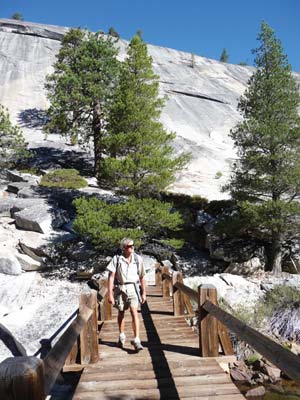
Bridges in the Hetch Hetchy area are built to withstand rushing snowmelt.
Unfortunately, the 2013 Rim Fire closed many backpacking trail options in Hetch Hetchy. Affected trails include the Preston Flat Trail, the trail to Kibbie Lake, and part of the summit trail to Smith Peak. Check with the Groveland Ranger Station for an update (209/962-7825). If and when these trails do open, they will offer an opportunity to examine forest recovery first-hand.
The Preston Flat Trail is located in Stanislaus National Forest, just outside of Yosemite. The trail heads to a stretch of river just west of Poopenaut Valley and offers good fishing and swimming opportunities, as well as many camping spots. When Cherry Lake and its trailhead reopen, backpackers will again be able to hit the four-mile hike to popular Kibbie Lake. The Kibbie Ridge Trail leads through lodgepole pine forest to the granite-bound lake at 6,800 feet elevation. The lake is fairly shallow and supports a good population of rainbow trout. This is a very short, rewarding backpacking trip that is suitable for most beginners.
Although the last few miles to the summit were severely burned in the 2013 Rim Fire, the trail to Smith Peak remains open to backpackers and day hikers. The trail can be accessed from several points; for ease of parking, most backpackers begin by the Mather Ranger Station (the trail begins 100 yards past the entrance kiosk, just beyond the ranger station on the right). Follow the Lookout Point Trail for 1.2 miles; then cut off on the trail to Smith Meadow. You’ll pass Base Line Camp Road and then climb up along Cottonwood Creek to Cottonwood Meadow, soon followed by Smith Meadow. A trail comes in on the right beyond Smith Meadow; this is another popular route to Smith Peak leading from White Wolf Lodge and Campground off Tioga Road. Campsites are found near this junction of trails. Get a good night’s rest before bagging Smith Peak the next morning. (You’ve hiked six miles thus far; it’s only two more to the summit.) The 7,751-foot peak is covered with pockmarked granite boulders and offers a panoramic view of Hetch Hetchy Reservoir and the Grand Canyon of the Tuolumne River.
There’s no better time than spring to hike along the northern edge of Hetch Hetchy Reservoir (elevation 3,796 feet) admiring three stunning waterfalls along the way: Tueeulala, Wapama, and Rancheria. An easy overnight backpacking trip leads to the eastern edge of the reservoir and Rancheria Falls (6.5 miles). Beware that the bears in this area are some of the boldest in all of Yosemite and bear canisters are required.
O’Shaughnessy Dam is the trailhead for Rancheria Falls. The trail to the Rancheria Falls backpackers’ camp is mostly level, with a total elevation gain of only 1,300 feet spread out over 6.5 miles. This makes it manageable even for most beginners. Fishing in the reservoir is fair to middling in spring and fall. And remember: Swimming is not allowed in this public water supply.
More adventurous backpackers will continue past Rancheria to Tiltill Valley (3 miles farther). Vernon Lake lies a half-day’s hike beyond (another 6.5 miles). The granite-backed lake is popular with those who tote along fishing gear in the hope of inviting a few rainbow trout to dinner. Good campsites can be found on Falls Creek (permits required) and also near the lake. Take this trip in the early season, however, because the route through Tiltill Valley is notoriously hot and dry in summer. You can easily turn this into a 27-mile loop by heading back via Beehive Meadow and Laurel Lake and then hiking south to Hetch Hetchy.
The same destinations can be reached via a shorter route (that’s preferred by many). Take the Beehive Trail northward from the edge of Hetch Hetchy Reservoir, one mile from the trailhead at O’Shaughnessy Dam. The trail follows an old road through a series of switchbacks, climbing 1,200 feet over two miles to the canyon rim. The trail then departs from the road and meanders on a much easier grade through pine and incense-cedar forest. Beautiful Laurel Lake is eight miles from O’Shaughnessy Dam. The lake is surrounded by aspen groves, firs, and lodgepole pines, and its waters are a fair bet for rainbow trout fishing. Spend your weekend here or set out for even more scenic Vernon Lake the next day (4 miles distant). Loop back via Tiltill Valley or retrace your steps.

A refreshing swim in Laurel Lake.
A short but steep Hetch Hetchy backpacking trail is the Poopenaut Valley Trail, which provides fast access to a beautiful stretch of the Tuolumne River. It’s a merciless downhill jaunt of 1.3 miles and 1,200 feet of elevation loss to a flat river stretch west of O’Shaughnessy Dam. If you like being close to a fast and free river, you’ll love the camping spots here. Fishing and swimming are excellent, but be wary of rattlesnakes, especially in spring. Because the trail’s so short, you might expect it to be crawling with day hikers, but they are noticeably absent except on occasional weekends. Nobody enjoys the return trip uphill, which, although brief, is the worst grade in all of Yosemite. Start early in the morning and make sure you’ve eaten everything in your pack. The trailhead is at a minuscule parking lot off Hetch Hetchy Road, 3.9 miles from the Mather Ranger Station.
Road bikers looking for a challenging ride can pedal from Evergreen Lodge or Camp Mather to Hetch Hetchy Reservoir on Hetch Hetchy Road (18 miles round-trip). The route is easy enough on the way in, but the climb back out offers one heck of a workout. Even though plenty of cars utilize this road, they don’t cause much of a hazard to cyclists because the narrow, winding thoroughfare forces them to keep their speed down.
For an easier ride on smooth pavement, from Evergreen Lodge pedal 0.5 mile north on Evergreen Road to Camp Mather. Go left on Forest Service Road 1S02, signed for Cherry Lake. The narrow, paved road follows a nearly level contour high above the Tuolumne River Canyon, offering wide views and colorful wildflower displays. At seven miles the road intersects with Cherry Lake Road. Retrace your tire tracks here, or turn left and continue eight miles to the waterfall and swimming hole at Rainbow Pool.
The Tuolumne River is a well-loved trout stream, and some of its best fishing prospects are found in the northwest stretch of Yosemite in and around the Hetch Hetchy region. For good angling only a short drive from Highway 120, head for the Middle Fork of the Tuolumne River, which is well stocked with pan-sized rainbow trout. A popular access point is the Middle Fork Day Use Area off Evergreen Road, one mile west of the Big Oak Flat entrance and on the road to Hetch Hetchy. If you seek more of a challenge, the main branch of the Tuolumne River is a favorite of more seasoned anglers, who ply its waters for trophy-sized native trout.
Many park visitors don’t realize that fishing is permitted in Hetch Hetchy Reservoir. The lake has brook trout, rainbow trout, and some large brown trout, but because anglers are permitted only to fish from shore, prospects are not great. The warm summer weather makes the fish go deep, and since anglers cannot launch boats into the lake, they have little chance of getting close to the fish. People usually fish while standing on the shoreline using spinners; no live bait is allowed. When they do catch trout, the fish are large. Fishing is best in spring and fall.
Those looking for more of a sure thing head for the west side of O’Shaughnessy Dam and the free-flowing stretch of the Tuolumne River. Hiking the short Poopenaut Valley Trail is one way to get to the river, but it’s too steep for all but the most ambitious anglers. (Many prefer the mellower Preston Flat Trail off Cherry Lake Road, which is currently closed due to the August 2013 Rim Fire, but will likely reopen by summer 2015.)
If you’re willing to take a backpacking trip from Hetch Hetchy, you will find plentiful fish in Laurel Lake and Lake Vernon. Both lakes have self-sustaining populations of rainbow trout, although both lakes are fished heavily. The stretch of Falls Creek near Lake Vernon is popular with fly fishers.
People who just want to fish, not hike, should drive to Lake Eleanor, located just northwest of Hetch Hetchy. Rainbow trout and bluegill are the usual catch. Access to Lake Eleanor is usually via Cherry Lake Road (off Highway 120, 14 miles east of Groveland), but note that this road is currently closed due to damage from 2013 Rim Fire. Typically the road to the lake is open only May 1-September 15. You must walk the final 0.25 mile to the lake.
Most anglers who make the long 28-mile drive to Lake Eleanor often plan to fish at larger and more popular Cherry Lake, located four miles west of Lake Eleanor, but the road is currently closed due to the Rim Fire. Cherry Lake is just outside of the Yosemite National Park boundary in Stanislaus National Forest, so in addition to excellent fishing for rainbow, brook, and brown trout, it features several amenities you won’t find at Lake Eleanor: a boat launch, a designated swim area, and a Forest Service-operated campground. The lake is stocked regularly, so it offers much more reliable fishing than Lake Eleanor.
The closest place to rent horses near Hetch Hetchy is at Mather Saddle and Pack Station (Camp Mather, 35250 Mather Rd., 209/379-2334 or 209/847-5753, www.mathersaddleandpackstation.com). Hourly, half-day, and all-day rides are available June-August. A popular choice is the Cowboy Breakfast Ride ($45 per person); horses and riders travel about an hour over a scenic mountain pass and then drop into a deep, grassy meadow where breakfast is waiting. Scrambled eggs, bacon, fried potatoes, cowboy coffee, and biscuits are cooked in a Dutch oven. The ride usually begins at 8am and ends by 11am. Another good choice is the Sunset Ride ($56 per person), in which riders and horses travel along the rim of the Grand Canyon of the Tuolumne River at sunset.
Just a few miles west of Hetch Hetchy Reservoir lies a spectacular river canyon known to rafters as a white-water jewel. Several commercial outfitters run trips down the Tuolumne River Canyon in the summer months. Access to this designated Wild and Scenic stretch of river—known to its biggest fans simply as “The T”—is a few miles off Highway 120 between Groveland and the Big Oak Flat entrance. The rafting put-in point is just north of Buck Meadows; the take-out is at Wards Ferry just east of Don Pedro Reservoir. Rafters usually meet at La Casa Loma River Store (Ferretti Rd. off Highway 120), eight miles east of Groveland.
Water flow on this 18-mile section of the Tuolumne is dependent on releases from Hetch Hetchy. When the river flow is high, this is a very advanced and exciting run of river in a remote canyon filled with birds and other wildlife. Class IV rapids are the rule, not the exception. Several local outfitters offer one-, two-, and three-day trips on the river April-September. For more information, contact Zephyr Whitewater (800/431-3636, www.zrafting.com), ARTA River Trips (209/962-7873 or 800/323-2782, www.arta.org), All-Outdoors California Whitewater Rafting (800/247-2387, www.aorafting.com), or OARS Inc. (800/346-6277, www.oars.com). Typical cost for a one-day trip is $189-249 per person; two-day trips are $329-499 per person; three-day trips are $499-649 per person. Specialty trips are sometimes available, including trips offering wine-tasting or live bluegrass music.
There are no accommodations or developed campgrounds in the Hetch Hetchy region of Yosemite. The town of Groveland, located on Highway 120 about 25 miles (45 minutes) west of the Big Oak Flat entrance, provides the nearest lodging, camping, and food.
The Hetch Hetchy backpackers’ campsites (no reservations) are designated for those beginning or ending a wilderness trip. Campers who wish to stay in these sites may do so for only one night before or after their backpacking trip, and they must have their wilderness permit in hand. The sites are walk-in only, and only backpacking equipment may be brought in.
Nine miles from the Big Oak Flat entrance and about halfway up the road to Hetch Hetchy, S Evergreen Lodge (33160 Evergreen Rd., Groveland, 209/379-2606 or 800/935-6343, www.evergreenlodge.com, $180-410) is a convenient place to stay for visiting either Yosemite’s high country or Hetch Hetchy’s spectacular water-filled valley. You can spend a comfortable night in your cabin and then get up early and head to the trailhead at Hetch Hetchy’s impressive dam, or drive into the main part of the park and cruise over to Tuolumne Meadows and Tioga Pass. Yosemite Valley is about an hour away.
The Lodge’s original 12 one- and two-bedroom cabins, which date back to the 1920s, sit side-by-side with 80 brand-new cabins, mostly duplexes. All of the cabins have custom-designed “woodsy” interiors, plus modern features like satellite radio. Those looking for a lower-priced overnight option can stay in one of 15 “custom campsites” ($85-121 per night in summer), which come furnished with tents, mattresses, sleeping bags, and pillows, so all you need to bring is your toothbrush. Additionally, large groups can rent the John Muir House ($875-1,175 per night in summer), a 2,500-square-foot vacation house.
The lodge can accommodate about 300 people at any one time, and on most summer nights, the resort is completely booked. There are tons of organized activities—nature hikes, full-moon hikes, guided bike rides—and most require an additional fee: There is a 2,000-square-foot, saline swimming pool, and an in-ground hot tub that can accommodate up to 14 people. With everything going on here, this is an ideal place for families and groups to stay.
The Evergreen Lodge Restaurant (7am-10pm daily in summer, shorter hours in winter, $18-28) is worth a stop whether you’re staying here or not. The menu changes often, but frequent highlights include wild boar tenderloin, grilled flatiron steak, elk tenderloin, and wild Alaskan salmon. An outdoor dining patio adds more summertime seating options.
Much of the national forest surrounding Dimond O (36 sites, 34660 Evergreen Rd., Groveland, 877/444-6777, www.recreation.gov, Apr.-Oct., $24 per night) was badly burned in the Rim Fire of August 2013, but the camp and its immediate surroundings were spared. This medium-sized campground, a short and easy drive off Highway 120, is meticulously managed by a concessionaire for the U.S. Forest Service. It’s just far enough so that it is peaceful and quiet amid the incense-cedars and ponderosa pines but still only about 15 minutes from Yosemite’s Big Oak Flat entrance. Dimond O makes a convenient choice if you plan to visit Hetch Hetchy (10.5 miles away) or if you want to fish in the Middle Fork of the Tuolumne River. A day-use area for the river is only 0.5 mile from the camp.
Dimond O’s sites are reservable May-September; sites are first-come, first-served October and April. The camp has drinking water, picnic tables, fire grills, and vault toilets; small trailers and RVs are fine here. The 4,400-foot elevation makes for pleasant temperatures, even on the hottest days. And if you feel warm, you can walk a short trail from camp right down to the river.
Dimond O is located 5.6 miles north of Highway 120 on Evergreen Road. The Evergreen Road turnoff is 25 miles east of Groveland or one mile west of the Big Oak Flat entrance.
A summer camp owned and operated by the city of San Francisco, Camp Mather (35250 Mather Rd., Groveland, 209/379-2284, www.campmather.com or www.sfrecpark.org, $7-14 day-use fee, mid-June-mid-Sept.) is situated just 1.5 miles south of the Hetch Hetchy entrance to Yosemite. If you’re a resident of San Francisco (or a very lucky non-resident), you may be able to win the reservation lottery and reserve a week’s stay. San Francisco residents get top priority in the lottery ($100 fee), which opens in early January and ends in early February each year. The family-friendly camp consists of rustic cabins ($457-1,222 per week) that sleep up to six people and tent sites ($236-318 per week). Bathhouses provide water and laundry services and a meal plan purchase ($19-36 per day) is also required.