ECONOMIC GEOGRAPHY OF CHINESE SEA POWER
Maritime geography is not fate. As Alfred Thayer Mahan observes, though, geography may have fateful consequences. Sea power is predicated on immutable “natural conditions” such as ready access to the high seas, the number and location of deepwater ports, and the length of the seaboard.1 Inescapable geophysical factors dictate which strategic options are available to seafaring nations. Geography thus may facilitate or fetter, channel or bound a nation’s maritime strategies. Not even the most sage policy and strategy can flout geospatial reality.
Likewise, China is endowed with—and burdened by—geographic characteristics that exert a discernible influence on how Chinese leaders view the nautical setting. Their perceptions of China’s surroundings in turn inform how decision makers formulate maritime strategy, put it into practice, and adjust it as circumstances change. In effect, then, there is a subterranean logic to Chinese sea power that is geographic in nature.
We argue that “geoeconomics,” defined broadly as the interplay between spatial and economic factors in international relations, exerts a powerful influence on China’s sea-power agenda.2 We contend that the complex, interlocking web of trading relationships that China has brought together since Deng Xiaoping’s reform and opening movement has drawn China permanently to the seas. Indeed, China’s economy is literally and figuratively leaning into the seas as citizens and industry crowd mainland shores. These demographic and socioeconomic upheavals have made—and will continue to make—a lasting and profound strategic impact on China’s maritime orientation.
Mahan’s Teachings and China’s Economic Geography
In The Influence of Sea Power upon History, 1660–1783, Alfred Thayer Mahan argues that production, shipping, and colonies and markets comprise sea power.3 By “production” Mahan means agricultural and industrial sectors that yield goods for sale on the market. Production also refers to the development of internal communications—roads, railways, canals—that facilitate the transport of goods from a country’s interior to trading hubs along its coasts. By “shipping” Mahan means not only ships that carry goods across the sea but also administrative functions and national regulations and laws—notably tariffs—that favor trade. By “colonies and markets” Mahan means foreign markets where finished goods can be sold and raw materials procured to supply manufacturing industries at home. He likens production, shipping, and colonies to three links in a chain, with shipping connecting the domestic economy to external marketplaces. A country enjoys meager prospects at sea unless it forges all three links.
Mahan’s three links of production, shipping, and colonies and markets have twenty-first-century analogues. While colonies are relics of a bygone era, Mahan would instantly comprehend the logic of today’s global markets. The postwar financial and trade architecture rests on the principle of market openness. Multilateral institutions, such as the World Trade Organization, ensure liberal access to markets for stakeholders in the U.S.-led international economic order. This commitment to openness remains a crucial ingredient in the mobility of goods and services—mobility that in turn facilitates global trade. Moreover, the global supply chain so essential to globalization mirrors Mahan’s ideas about “peaceful commerce and shipping.”4 Companies worldwide have constructed an intricate network of interrelationships to produce and handle goods and services, and to distribute them between international markets. Again, Mahan would have been no stranger to the basic mechanisms constituting the modern trading system.
Importantly, this global supply chain has shifted decisively to China. Three distinct clusters of economic activities that characterize global trade, or what Jean-Paul Rodrigue calls “the geography of production, distribution, and consumption,” can now be mapped onto China.5 Over the past three decades, firms in developed economies have migrated to China in search of cheap labor, tailor-made infrastructure, and tax incentives. The resulting concentration of global production lowered costs for these firms while transforming China—in particular, urban centers along the coast—into the world’s factory floor. Local seaports and transportation networks developed, helping the resultant mountains of made-in-China goods reach customers across the globe. High-tech, ultracapacity port facilities sprang up along China’s shores to feed the global supply chain. North American, Northeast Asian, and Western European customers brandishing enormous purchasing power have driven demand for goods produced in and distributed from China.
Rodrigue’s theory of the global supply chain transposes Mahan’s concept of commercially driven sea power into the modern era. Mahan illustrates the essential logic of maritime trade, even if processes specific to his day no longer apply—hence the timelessness and contemporary appeal of his writings. China’s prominence in the global supply chain, a system that remains predominantly maritime in nature, thus offers promising insights into Chinese sea power. Capturing the entire chain of production, distribution, and consumption would constitute a monumental task, and one we will not attempt here. Instead this chapter examines the distribution link—China’s port system, in particular—that delivers goods to the marketplace. This link ranks among the clearest manifestations of sea power and maritime trade. It is also a useful proxy for gauging production and consumption.
Consider the central part seaports play in maritime trade. Ports represent an essential component of distribution, the connective tissue between goods produced at home and shipping that transports those goods abroad. Ports and the global supply chain to which they are attached are essential to meeting demand for goods in foreign markets—goods that must be shipped by sea. At the same time such distribution networks and nodes must ensure that imported goods can adequately meet domestic needs. The number, capacity, and efficiency of ports are thus useful measures of production, distribution, and consumption.
Ports themselves stimulate production and consumption. Export-oriented manufacturers have an incentive to position themselves near ports or transportation networks connected to ports, thereby reducing transportation costs. In turn, industries located in or near port cities attract labor and capital, drawing new workers to the coast. As the local population and economy grow, residents with rising disposable incomes fuel more demand for imported goods. Trade begets wealth, and wealth begets more trade, generating a virtuous cycle of productivity and profit growth. Port systems thus are interwoven with a country’s industrial capacity, financial strength, and demographic patterns.
The number and quality of seaports also indicate whether geographical and other structural factors—Mahan’s natural conditions—favor maritime trade and thus sea power. To Mahan, proximity to important sea-lanes, the length of the shoreline, the number and quality of harbors, the degree to which the population’s well-being depends on the seas, and other factors innate to a country represent essential elements of sea power. The development and health of a seafaring country’s port system depend on these features and in turn sustain its sea power.
The volume and patterns of Chinese maritime trade illustrate the importance of ports to China’s economic vitality and to its development as a sea power. More than 90 percent of China’s imports and more than 85 percent of its exports travel by water. In 2016, measured by the value of goods transported, South Korea, Japan, Taiwan, the United States, and Germany (in descending order) were China’s top five sources of imports, while the United States, Japan, South Korea, Germany, and Vietnam were China’s top five export destinations.6 Intra-Asian, transpacific, and Eurasian trade dominates Chinese seaborne commerce, reflecting a clear production-consumption relationship in which consumers clustered in North America, Northeast Asia, and Western Europe absorb much of what China produces.
In 2011, for instance, China’s top five partners were Australia, Indonesia, Brazil, the United States, and South Africa in terms of seaborne imports measured by tonnage. Australia accounted for more than 20 percent of the total, of which raw materials accounted for more than 85 percent. Measured by the value of goods imported by sea, China’s top five suppliers were Japan, South Korea, Taiwan, the United States, and Australia. Japan accounted for more than 10 percent of the total (in dollar terms), of which manufactured goods claimed more than 95 percent. China’s five largest export destinations by sea were the United States, South Korea, Japan, Taiwan, and India (measured by volume). The United States absorbed just over 10 percent of the total (measured by tonnage), of which nearly 90 percent was in manufactured goods. The United States was also the largest export market for China by value, representing nearly a quarter of the global share, of which 98 percent fell into the category of manufactured goods.
China’s 14,500-kilometer coastline is the physical interface for goods transported to and from the Chinese homeland. Port facilities dotting the shoreline connect shipping to some of the world’s busiest shipping lanes. China’s main seaports handle cargoes that are shipped along the transpacific, Europe–Far East, and Southeast Asia–Far East trade routes. Not only is China a destination for and origin of seaborne commerce, it is also a transshipment hub for global trade.
China’s standing is impressive. According to the UN Conference on Trade and Development, “Chinese ports operate the largest number of berths (31,705) and handle more cargo both in terms of metric ton volume and number of TEUs [20-foot equivalent units] than any other country.”7 TEUs are a standard measurement used to denote the cargo carrying capacity of container ships and port terminals. As one can see, China’s seaports have experienced enormous aggregate growth, handling 41 million TEUs in 2000 and more than 155 million TEUs in 2012.8 China logged 170 million TEUs in 2013, ranking first in the world. Singapore and South Korea trailed at 33 and 23 million TEUs, respectively.9
In terms of tonnage throughput, Chinese ports processed 7.84 billion tons of goods in 2015 compared with just 1.25 billion tons in 2000—a sixfold increase.10 Measured by TEUs, eight of China’s ports rank among the top twenty ports in the world. Shanghai, Shenzhen, Ningbo-Zhoushan, Guangzhou, Qingdao, Tianjin, Dalian, and Xiamen ports are ranked first, third, fourth, seventh, eighth, tenth, fifteenth, and sixteenth, respectively.11 Measured by tonnage, thirteen of China’s ports are among the top twenty in the world. Ningbo-Zhoushan, Shanghai, Tianjin, Suzhou, Guangzhou, Qingdao, Tangshan, Dalian, Rizhao, Yingkou, Qinhuangdao, Shenzhen, and Xiamen rank first, second, fourth, fifth, sixth, seventh, eighth, eleventh, twelfth, thirteenth, seventeenth, nineteenth, and twentieth, respectively.12
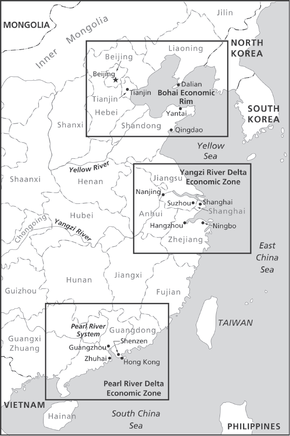
Three clusters of port systems, one apiece in southern, eastern, and northern China, have emerged as the leading players in maritime trade. In 2017 the Pearl River Delta (PRD) region to the south, the Yangtze River Delta (YRD) region to the east, and the Bohai Economic Rim, spanning the northerly Beijing-Tianjin-Hebei region, accounted for 36 percent of China’s GDP. Considering that these sectors collectively represent less than 3 percent of China’s landmass and less than 20 percent of the country’s population, they stand out for their economic openness, dynamism, innovation, and productivity.13 Indeed, each regional cluster forms a distinct geography of production, distribution, and consumption.
These hubs are essential to understanding China’s dependence on seaborne commerce for its economic vibrancy in particular and its oceanic orientation in general. This dependence in turn offers a glimpse of the larger drivers that are shaping China’s perceptions of the maritime domain and of strategic imperatives at sea.
Pearl River Delta Economic Zone
In 1979 paramount leader Deng Xiaoping authorized four special economic zones: in Shenzhen, Zhuhai, and Shantou in Guangdong Province; and in Xiamen in Fujian Province. Deng’s proclamation marked the first step in China’s reform and opening era. Beginning in the 1980s, Shenzhen, the geographic epicenter of the market reforms, attracted foreign direct investment from Hong Kong, Taiwan, Japan, and the United States, among others. The resulting boom in manufacturing and exports quickly spread and amalgamated the neighboring cities and towns into an integrated economic region, the PRD Economic Zone.
The delta’s economic development over the past decades illustrates how production, distribution, and consumption clusters have coalesced across China. The PRD region is a major manufacturing hub that produces intermediate inputs destined for final assembly elsewhere as well as finished products to be exported or consumed at home. It is a distribution center connected to global supply-chain networks that reach international and domestic markets. And as residents of the delta have come to enjoy greater wealth, the region itself has generated growing demand for imported and domestically produced goods and services.
The PRD region is best understood as a megalopolis—a band of urbanized, industrialized cities sprawling across at least 150 kilometers. The “BosWash corridor” along the eastern seaboard of the United States, stretching from Boston through New York and Philadelphia to Washington, DC, is a classic example of a megalopolis; so is the Tokyo-Nagoya-Osaka belt along Japan’s Pacific-facing coast. A megalopolis is both a geographic and an economic expression of a massive urban area. As Edward Leman observes: “What makes a megalopolis unique and important is that it is usually the principal economic powerhouse of a country or region—a concentration of consumers, purchasing power, and production that incubates higher forms of economic development and growth. As transportation and communications linkages improve among multiple centers, ‘urban-rural’ boundaries disappear in a rapidly changing web of economic activity.”14
From west to east, Zhuhai, Zhongshan, Jiangmen, Foshan, Guangzhou, Dongguan, and Shenzhen form a semicircle around the Pearl River Estuary, which empties southward into the South China Sea. According to the World Bank, the PRD urban area, excluding the special administrative regions of Hong Kong and Macau, encompassed nearly 7,000 square kilometers in 2010. An astonishing 42 million people live in this “interconnected urban mass,” where it is virtually impossible to delineate city boundaries.15 Attesting to the speed and growth of urbanization, the PRD covered 4,000 square kilometers and was home to 27 million people a decade before. The transformation of Shenzhen constitutes perhaps the most dramatic example of the PRD’s astounding growth. When Deng designated Shenzhen a special economic zone in 1979, about 25,000 people lived in this sleepy village. By 2011 the city had swelled to exceed 10 million inhabitants, an astounding 400-fold increase in just three decades.
Any account of the PRD would be incomplete without Hong Kong, an economic and maritime powerhouse in its own right. China’s initial opening to the world in the late 1970s was closely linked to the coastal enclave. Proximity to Hong Kong was one reason Deng selected Shenzhen as a laboratory for reform. Hong Kong was conceived as a staging area through which capital from the city and overseas would flow into Shenzhen. Lower-end manufacturers in Hong Kong moved north into China while higher-value-added industries and service-oriented firms took their place. At the same time, Hong Kong emerged as a major distribution center connecting China to the outside world. For a time in the 2000s, Hong Kong was the largest container port in the world.
Since then the PRD has emerged as a center of maritime exchange. Hong Kong, Shenzhen, and Guangzhou rank among the world’s top ten ports. Measured in terms of container throughput, the ports of Shenzhen and Guangzhou ranked fourth (at 22.9 million TEUs) and seventh (14.7 million TEUs), respectively, in 2012. Hong Kong placed third that year, logging 23.12 million TEUs. Earlier concerns that southern Chinese ports would compete with Hong Kong waned as a division of labor emerged. Shenzhen and Guangzhou now function largely as gateway ports for the export of Chinese goods overseas, while Hong Kong has retained its central role as a global transshipment hub for cargo to and from China and other international markets.16 If commerce commands the overriding importance Mahan discerns, then the PRD constitutes the southerly element of a durable commercial substructure for Chinese sea power.
Yangtze River Delta Economic Zone
The YRD Economic Zone straddles Zhejiang Province to the south and Jiangsu Province to the north, with Shanghai situated at its center. Sixteen cities, including such heavyweights as Nanjing, Suzhou, Hangzhou, and Ningbo, constitute the YRD region, which sprawls across 210,000 square kilometers. The YRD produces about one-fifth of China’s GDP, generates nearly one-fourth of its fiscal revenues, and can claim almost half of its total foreign trade. In 1986 the Chinese government designated Shanghai China’s leading city in economic, financial, technological, maritime, and cultural affairs. Like Shenzhen, Shanghai soon became a magnet for foreign capital, impelling rapid growth while accelerating the transition to service-oriented and high-tech industries. Shanghai’s emergence as a global city has uplifted the delta region as a whole. Between 2000 and 2010, Shanghai’s population burgeoned from 14 million to 24 million while its urban area more than doubled from 1,600 square kilometers to 3,500 square kilometers. In the process the metropolis absorbed neighboring cities such as Suzhou, a city of more than 5 million people to Shanghai’s west.17
In 2010 Shanghai displaced Singapore as the top port in the world as measured by container throughput, at 29 million TEUs. Two years later the port handled 32.5 million TEUs, edging out Singapore in throughput and global market share. These statistics are all the more remarkable when compared to Shanghai’s humble beginnings in the 1970s. Only in 1977 did the port obtain equipment imported from Japan to start handling standardized containers used in international shipping. In 1978 Shanghai handled fewer than 10,000 TEUs. Cargo traffic started to soar, however, following the opening of container shipping routes to the United States, Japan, and Europe in the early 1980s. In 1983 container throughput neared 80,000 TEUs. Throughput soared to 570,000 TEUs in 1991, but Shanghai still lagged far behind the leading global ports. Hong Kong and Singapore handled 6 million and 6.3 million TEUs, respectively, that year. Shanghai swiftly caught up in the new century, handling 5.6 million TEUs in 2000, then almost tripling that total to 14.5 million TEUs in 2004.
The port of Shanghai feeds the city’s socioeconomic vitality. Port-related industries ranging from construction to shipping and finance have contributed to the wider local economy. According to the Organization for Economic Cooperation and Development, the seaport is directly or indirectly responsible for about 20 percent of Shanghai’s contribution to GDP and 20 percent of the city’s jobs.18 The headquarters of China’s three largest carriers (COSCO, China Shipping Container Lines, and Sinotrans Shipping) and twenty other global shipping firms call Shanghai home. In addition, 66 international carriers, 630 ship agencies, and 350 international freight forwarders are based in the city.19
Ningbo, located about 150 kilometers south of Shanghai across Hangzhou Bay, is another major port in the YRD. A natural deepwater port, Ningbo is well connected to manufacturing hubs in coastal Zhejiang and farther inland in Jiangxi and Hubei. In 2012 the ports of Ningbo and nearby Zhoushan together ranked sixth in the world in terms of throughput, handling nearly 17 million TEUs. That same year Ningbo surpassed Shanghai in terms of throughput tonnage. The Chinese government formally merged the two ports three years later. Among the busiest harbors in the world, Ningbo-Zhoushan handled more than 230 routes that reached more than 600 ports around the globe in 2015.20
Significantly, the Chinese authorities designated Ningbo-Zhoushan to lead the Port Economic Rim (港口经济圈) initiative. Under the initiative the twin ports will act as a transportation hub that connects nearby cities and ports to China’s interior and to global markets. Ningbo-Zhoushan will play a critical role in meeting the demands of Xi Jinping’s One Belt, One Road strategy, an ambitious effort to finance economic development and infrastructure in Eurasia.21 The global supply chain will run through the port, joining local economies from the YRD Economic Zone to Eurasian markets by land and sea.
Planners envision three concentric rings of interrelationships emanating from Ningbo-Zhoushan. The innermost circle, comprising the twin ports and the surrounding cluster of cities, will propel local economic, social, cultural, and ecological development. This core zone will extend its ties to the next ring, which encompasses the YRD region as a whole, through transportation, trade, investment, and production networks. In turn these interactions will radiate to the outermost circle, which encompasses all of eastern China, in the form of finance, tourism, and other service-oriented industries. The Port Economic Rim concept rests firmly on China’s geography of production, distribution, and consumption.
Interior maritime geography matters. Mahan extolled the Mississippi River and its tributaries for placing the continental interior of North America in contact with the Gulf of Mexico and thence with trade routes spanning the seven seas. The muddy Mississippi constituted Americans’ gateway to the world. Internal waterways spared American manufacturers and agricultural interests much of the burden and cost of transporting goods overland to coastal harbors. Mahan also stressed the need for harbor infrastructure in remote regions to support mercantile and naval endeavors. It is doubtful that CCP leaders needed Mahan to give them the idea of turning China’s riverine system to economic advantage. Nevertheless, his writings ratify what they have done by merging Ningbo and Zhoushan and centering the One Belt, One Road initiative on the combined port. Beijing has taken Mahanian logic to heart—and put it to practical use.22
Bohai Bay Economic Rim
With a coastline spanning more than 5,000 kilometers, the Bohai Bay rim includes Liaoning, Hebei, and Shandong Provinces and the municipality of Tianjin. It forms a C-shaped arc around the Bohai Sea, an inland sea covering 823,000 square kilometers. Running clockwise from the south coast of Shandong Peninsula, the major port cities of the Bohai region include Qingdao, Weihai, Yantai, Huanghua, Tianjin, Tangshan, Qinhuangdao, Jinzhou, Yinkou, Dalian, and Dandong, the latter located along the North Korean border.
If major inland cities such as Beijing, Shenyang, and Jinan are included, more than 66 million people live along the Bohai Bay rim. The region boasts three of the busiest ports in the world: Dalian, Tianjin, and Qingdao ports rank comfortably in the top twenty in terms of container throughput. In 2012 these ports collectively handled 34.8 million TEUs, 2 million more than Shanghai. At the epicenter of this economic cluster sits Tianjin, the portal to Beijing and the interior. Transportation networks connect the Bohai region to Shanxi, Henan, and Inner Mongolia.
A far larger riverine-based ecosystem defines the economic rim. The Yellow, Liao, and Hai Rivers drain into Bohai Bay. The river basins that surround the Bohai Sea cover a land area of 1.6 million square kilometers, accounting for 15 percent of China’s total landmass. More than a third of China’s inhabitants—about 350 million people—live in this area. That makes the Bohai River basin system the third largest in the world by population size. And in terms of economic heft, the Bohai basin region contributes about one-fifth of China’s GDP. Here again, the Mahanian logic of commercial enterprise and seaborne communications is on full display.
Inland Waterways and Ports
Internal waterways, including navigable rivers, canals, and inland waters, have always been an important feature of China’s maritime and riverine trade. China enjoys 110,000 kilometers of navigable waterways. This represents the world’s longest riverine system, followed closely by Russia, whose usable waterways extend across 102,000 kilometers. The Yangtze River in particular constitutes a crucial economic artery connecting the seacoast to the backcountry. Indeed, the Yangtze is the longest navigable waterway in the world. Vessels can traverse about 2,800 kilometers of this 6,400-kilometer-long river. Waterborne transport reaches such major cities as Nanjing, Wuhan, and Chongqing, the latter a megacity of 17 million people located almost 1,700 kilometers from the coast.
Ports along the Yangtze are by far the busiest in terms of volume and throughput by comparison to other river ports in China.23 As an entryway to China’s interior and beyond, Chongqing’s Guoyuan Port acts as a transshipment hub whereby goods are shipped to Europe along railways running through the far western province of Xinjiang. For its part, Wuhan straddles the junction of north-south and east-west transportation axes. The city connects the upper and lower sections of the Yangtze, facilitating trade between Chongqing and Shanghai. It lies roughly midway along the Beijing-Guangzhou rail line. Wuhan also feeds Shanghai with goods transported from the interior, including from Xian, Changsha, Kunming, and Zhengzhou.24
Modernization, dredging, and expansion of port facilities have substantially boosted inland China’s capacity for water transport. Demand for better internal communications has swelled, furthermore, as manufacturing industries have moved farther inland. Between 1990 and 2005 the inland water ports’ throughput exploded from 0.2 million TEUs to 19.4 million TEUs—a remarkable 97-fold leap in cargo handling.25 And in 2010 inland waterway freight surpassed rail freight by volume. (It remains a distant second behind road freight, the dominant form of transportation in China.)26 River transport moved 5.6 billion tons of goods in 2013 compared with 4 billion tons that went by rail.27
Inland, or “dry,” ports represent another component of China’s interior transportation network. Starting in 2002, such facilities eased congestion at ports along the coast while injecting economic activity into the hinterlands as part of China’s larger development strategy. These ports are connected to seaports by road or rail. They function as temporary storage sites before cargo is transported elsewhere, or they can serve as clearinghouses for customs and other logistical services. The distances between these satellite ports and seaports can range from 70 to 1,500 kilometers.28 For example, the Shijiazhuang dry port in Hebei Province—located 400 kilometers from Tianjin, its mother seaport—is a gateway to Shanxi and Shandong Provinces.29 These trends suggest that even China’s interior regions are increasingly linked to events at sea and along the coast. Mahan would nod knowingly.
Geoeconomics and Chinese Sea Power
Several strategic preconditions permitted China to reorient its economic development strategy away from the autarkic continentalism of the Maoist era toward the open maritime trading system. The absence of great-power wars since the end of World War II and the expectation that the long peace underwritten by the United States and its allies would last for decades were essential ingredients in Deng Xiaoping’s grand strategy of peace and development. Since the reform and opening era, China has generally embraced key tenets of the U.S.-led liberal international order, including the rules- and norms-based economic order that promotes the free flow of goods, services, capital, and knowledge.
In exchange for China’s acquiescence, the United States and its trading partners opened their markets to Chinese goods, invested in China, and permitted China access to capital, technology, and know-how. China’s integration into the existing order was the driving force behind the expanding geography of production, distribution, and consumption along the Chinese coast.
China also benefited from a historical anomaly: peace to its north. From antiquity to the Cold War’s endgame, Chinese leaders were transfixed by regime-toppling menaces from the vast Eurasian heartland. From the horsemen of the Central Asian steppes to Soviet nuclear-capable tank divisions, threats from the Eurasian heartland had dominated the strategic calculus of Chinese decision makers for millennia. The breakup of the Soviet Union and the retreat of Russian power transformed China’s security equation, arguably for the first time in its modern history. China’s strategic marriage of convenience with Vladimir Putin’s Russia has kept its northern frontier quiet thus far.
Continental calm allowed Chinese statesmen to devote their energies to saltwater-centric economic development. It is against this backdrop of a highly favorable international security environment—or what President Jiang Zemin in 2002 termed a “period of strategic opportunity”—that China’s coastal megalopolises have flourished.
This survey of China’s port system and its enormous impact on the country’s socioeconomic structures also demonstrates the enduring relevance of Mahanian sea-power theory. Mahan contended that peace and peacetime commerce are indispensable to the development of sea power. Chinese leaders availed themselves of an unprecedented window of opportunity, when peace prevailed on land and trade beckoned at sea, to amass comprehensive national power. The economic activities clustered around the Bohai Rim, the YRD, and the PRD validate Mahan’s accent on production, shipping, and markets as constituents of sea power. Significantly, the nonmilitary components of sea power proved to be the decisive components as Chinese sea power took shape. And in accord with Mahan’s theory, geography—including long shorelines, plentiful harbors, and access to the high seas—favored intense interactions among commerce, ships, and bases. Comprehending the interplay among these elements is essential to comprehending China’s ascent at sea.
Mahan’s philosophy of sea power not only helps explain the immense concentrations of economic productivity, wealth, and populations scattered along the coast, but also suggests strongly that China’s economic destiny is now inextricably tied to the seas. Outsiders’ conviction that landward concerns will always outweigh maritime imperatives for China does not comport with current realities. The livelihoods of hundreds of millions of Chinese citizens rely on the seas directly or indirectly, and the Maoist doctrine of economic self-reliance is dead. Indeed, China’s integration into the maritime-based global trading system verges on irreversible. Hu Bo, a scholar at Peking University’s Maritime Strategy Research Center, observes that
seaborne transports complete eighty-five percent of China’s trade in goods, measured by volume. Nineteen percent of the global shipping market’s bulk goods head for China while twenty-two percent of the world’s containers are shipped from China. China’s merchant fleet reaches some 1,200 ports worldwide. China has already become an outward-oriented economic power dependent on the sea-lanes. China’s economy is already a thoroughly outward-looking economy.30 (Our emphasis)
Decades of migration, infrastructure development, financial investment, and industrial sprawl along the seaboard have locked China permanently into the seagoing mercantile system. Short of a calamity that brings down the current economic order or fundamentally realigns the international system—such as a great-power war, a global economic meltdown on par with the Great Depression, or a return of Sino-Russian enmity—China will remain oriented toward the seas.
The peacetime elements of sea power constitute essential sources of Chinese prosperity, spurring economic growth that has powered China’s rise to regional and world eminence. Newfound wealth sluiced revenues into government coffers, enabling the CCP to spend lavishly on the military, including the navy. China’s defense budget enjoyed double-digit growth every year for nearly two decades until 2015. In 2008 it sped past the United Kingdom as a defense spender, posting the world’s second-largest budget. More important, the growth rate in military expenditures has consistently exceeded the pace of overall GDP growth, reflecting the priority the leadership assigns to military strength.
Consequently, the PLA has bulked up on a steady diet of headline-grabbing hardware such as stealth fighters and aircraft carriers. These power-projection tools promise to secure China’s sea routes, both near and distant, along with far-flung economic interests. Through what King’s College London professor Geoffrey Till terms a “virtuous maritime circle,” trade begets resources, resources beget naval power, and naval power begets the means to strive for maritime dominance while safeguarding trade and resources.31 China is clearly a beneficiary of Till’s positive-sum cycle.
Most relevant to this study, the geography of Chinese production, distribution, and consumption has imposed new strategic demands on Beijing. China’s most important economic centers are now located along the northern, eastern, and southern shores. The well-being of these megalopolises and the overall health of the Chinese economy depend on easy access to the maritime common that connects China to global markets. Hu Bo contends, “To this day, the push and pull of foreign trade remains the greatest force behind China’s economic development. This type of economy is undoubtedly quite fragile and could easily fall prey to the influence of external factors. The disruption to sea lines of communication would immediately impact domestic economic development. Thus, economic security has already far surpassed the boundaries of national sovereignty.”32
An economy like China’s that is enmeshed with the wider world compels statesmen to devise security strategies to defend globally connected economic interests. Homeland defense takes on new meaning in this context. The seas just off China’s coasts are now organically connected to Tianjin, Shanghai, and Shenzhen. As such, China must defend forward at sea to protect these vital port cities and the millions of inhabitants packed densely into them.
Embracing an outward defense posture has upended long-standing strategic doctrine. Beijing can no longer trust in Mao’s martial script, which called for luring enemies deep into the hinterland. Throughout the Cold War, China prepared for a protracted conflict waged by the masses against materially superior foes such as the Soviet Union and the United States. In the event of war with the superpowers, defense planners envisioned staging an organized retreat into the Chinese heartland to draw in advancing enemy forces. They hoped to exploit China’s strategic depth, overextending the enemy while they tapped the massive reservoir of manpower to fight an insurgency on a continental scale. After the vast interior sucked in the invaders, China would wear them down through “people’s war.” Armed groups numbering in the millions would wage guerilla warfare, outlasting the invaders.
China can no longer afford to trade space for time. The only space China’s defenders could trade would be coastal centers of economic concentration that are critical to Chinese sea power and to the CCP’s legitimacy and survival. This would never do. Hostilities at China’s doorstep would pose an immediate danger to China’s economic well-being and even its survival. Lost access to offshore waters would exact a terrible toll from the economies on the Chinese seaboard. And Beijing must prepare to defend the urban centers from attack in case their inhabitants become targets of coercion. In this age of long-range, precision-strike weaponry, China must undertake a forward defense to buffer China’s coastal regions. In the eyes of Chinese strategists, no responsible leader could countenance letting outside powers take the littoral metropolises hostage.
Lin Hongyu, who chairs the Department of International Relations at the China University of International Relations, explicitly relates China’s defense strategy to the nation’s geography of production, distribution, and consumption:
After some 30 years of reform and opening, China today is no longer the poor China of yesteryear that had nothing to lose. Rather, China has much to lose. As a result, “meeting the enemy well beyond the nation’s doorway” has become the inevitable choice for China’s national defense strategy today. More than 60% of the nation’s wealth and the most important political, economic, and cultural centers are concentrated on China’s eastern territory. This area urgently needs the protection of a “strategic buffer zone.” And the eastern edge of this strategic buffer zone is the first island chain. China’s future military power should operate frequently in this strategic buffer zone and western countries, especially Japan, must become accustomed to this reality.33
Lin acknowledges that the Maoist days of deprivation and isolation are over. At the same time he clearly believes that China’s major coastal areas are now exposed to outside threats and that there is no turning back. To blunt these external dangers he espouses a forward military posture that extends at a minimum to the first island chain, the archipelago that stretches southward from Japan to the Philippines. As the next chapter will show in greater detail, Chinese strategists endorse the idea that China must push its defensive perimeter as far offshore as possible. Huang Feilian and Wang Wenhua concur that protecting China’s seaboard is a prerequisite for its economic health and quest for great-power status:
Currently, more than a third of the population and large- and medium-sized cities, 84% of foreign direct investment, and more than 70% of GDP are concentrated in our nation’s coastal areas. Defending these economically developed regions from seaborne assault, maintaining a safe maritime security environment, and protecting the great accomplishments of reform and opening are connected to the larger strategic picture of national security and development. In recent years, the maritime security environment’s impact on our national security has become ever greater. Implementing a maritime great power strategy has great import for maintaining maritime security, for breaking America’s strategic containment, and for ensuring strategic sea lane security.34
Notably, the authors see the United States as an obstacle to China’s aspirations. And they believe that a “maritime great-power strategy” that makes use of all implements of national power constitutes the surest way to secure long-term objectives. In short, defense at home frees China to pursue great power abroad. Mahan would find their appraisal of the interplay among commerce, wealth, military power, and national greatness quite familiar. Huang and Wang have subscribed to the Mahanian logic of sea power.
It is important to note that the geography of production, distribution, and consumption is not a straitjacket. In itself it does not dictate the choices that a would-be maritime power makes about its defense posture and naval strategy. Nations and the statesmen who run them set the agenda. An outwardly oriented economy simply directs the gaze of decision makers beyond national frontiers. How they manage the burdens and vulnerabilities associated with an extroverted geoeconomic system is up to them. That China apparently covets national greatness at sea, sees the United States and Japan as barriers to that greatness, and wants to install a security buffer along its marine frontier cannot be ascribed to geoeconomic factors alone.
Indeed, China could have pursued other grand strategies while laboring under the same geoeconomic circumstances. For instance, it could have let Deng Xiaoping’s directive to concentrate on peace and development remain in force. Deng’s low-profile approach to regional and international affairs focused primarily on nurturing economic growth. The regime could have committed itself firmly to the current liberal international order, acting as the “responsible stakeholder” American policy makers long hoped it would become. Or Beijing could have kept free riding on the global system despite having qualms about doing so. It could have allowed the United States to bear the burden of furnishing such international public goods as maritime security.
These different pathways might have produced very different strategies and force structures. For example, China’s navy could have continued investing in coastal defense or built lightly armed forces in bulk to prosecute constabulary missions. China could well have eschewed a naval buildup altogether. There is nothing foreordained about China’s geoeconomic circumstances or strategic choices related to sea power. Instead China chose a different course. It has pursued a combative approach to maritime affairs, as manifest in the martial undertones of the Chinese writings quoted above. Clearly, a multitude of intervening factors—geostrategic challenges, troubled history with neighbors, unresolved territorial disputes, and China’s sense of its place and purpose in Asia and beyond, not to mention worries about the regime’s legitimacy and internal stability—influence thinking about the efficacy of the diplomatic and military means available to Chinese leaders.
The next chapter continues probing the geographic constituent of Chinese sea power, zeroing in on the geostrategic environment that awaits China as it turns seaward. If geoeconomic factors nudge China seaward, then geostrategic considerations deepen the leadership’s insecurities about the seas. Fears of foreign encirclement reinforce the narrative that China must be militarily strong and assertive at sea. We show that misgivings about their nation’s nautical surroundings influence Chinese leaders’ thinking about military and naval strategy—and especially about future wars along the aquatic periphery.