STRATEGIC GEOGRAPHY OF CHINESE SEA POWER
In military strategy as in geoeconomics, geography is not fate. But it does mold fate. Chinese strategists are acutely conscious of this. When they take stock of China’s oceanic future, strategists glimpse everlasting struggle amid claustrophobic surroundings. To Chinese eyes the string of islands just offshore—the “first island chain” enclosing Eurasia’s eastern crest—resembles a Great Wall in reverse where Americans and their allies occupy the sentinel towers. The island chain imprisons China’s freedom of oceangoing movement. This preoccupation with geography is integral to Chinese discourses about sea power—and thus about China’s dream of national vigor and majesty.
We contend that the archipelagic concept casts a long shadow over Chinese strategic thought. It shapes how Chinese leaders perceive threats and in turn informs how they think about strategic and operational requirements for maritime defense. To them the island chain constitutes not just a physical barrier but also a metaphor for the resistance they expect from the occupants of the first island chain, including such potent maritime competitors as Japan and the United States. Consequently, the most fitting metaphor for the island chain is a barricade—a line of physical obstacles occupied by active defenders to ward off an opposing force. Beijing’s effort to ameliorate its island-chain quandary thus helps outsiders probe the nexus of marine geography, sea power, and great-power politics in Asia.
The First Island Chain: A Line at Sea?
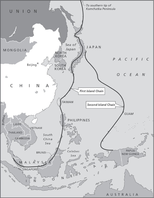
The term “first island chain” refers to the offshore archipelago that envelops Eurasia’s eastern seaboard in its entirety. While Western commentators differ over which features constitute the island chain, most concur that it centers primarily on the Japanese home islands, the Ryukyu Islands, Taiwan, and the Philippine Islands. The first island chain is a geographic construct peculiar to China’s worldview, which situates the Chinese mainland at the epicenter of maritime Asia. And indeed, a seaward-looking China cannot avoid facing the islands. The island chain roughly parallels the nation’s long coastline, and no Chinese harbor outflanks it. Worse, Japan, Taiwan, and the Philippines constitute the “first” island chain only because a more distant, looser island group centered on Guam—the “second island chain”—forms an additional concentric ring around China. In short, China’s unique vantage point infuses the island-chain concept with tangible geospatial meaning.
Analysts outside China began to detect this Sinocentric perspective in Chinese official discourse in the late 1980s and early 1990s. Among the first to report on the phrase in Western scholarship were You Ji and You Xu of the Australian National University. In 1991 they claimed that the first island chain comprises Japan, the Ryukyus, and the Philippines.1 Three years later Alexander Huang defined the island chain more concretely, maintaining that it encompasses “the Aleutians, the Kuriles, the Japanese archipelago, the Ryukyus, Taiwan, the Philippine archipelago, and the Greater Sunda Islands.”2 In 2001 historian and retired U.S. Navy captain Bernard Cole asserted that the island chain runs southward from the Kurile Islands and terminates at Borneo and Natuna Besar.3 The phrase has seeped into the mainstream Western academic lexicon over the past two decades, aided by analyses such as these.
In recent years this geographic concept has diffused beyond the small circle of China and defense specialists in the West. Official U.S. reports about China’s military and naval modernization use it to describe Chinese geospatial thinking. The Pentagon’s 2006 annual report on Chinese military power delineated the geographic makeup of the first island chain for the first time.4 In a 2009 study of the Chinese navy, the Office of Naval Intelligence (ONI) produced a map that traces the first island chain.5 The phrase, moreover, now surfaces regularly in the popular press.6 Robert D. Kaplan, who has done more than any other journalist to draw attention to China’s maritime ambitions, explicitly referred to it in a 2010 opinion column.7 It is remarkable that an obscure term coined in the recesses of China’s massive military bureaucracy more than thirty years ago has found its way into common parlance in Western newspapers, on websites, and in official documents.
Despite wider usage and acceptance, analysts disagree over the conceptual value of the first island chain. Some naval experts hold that China’s apparent obsession with the archipelagic construct might degrade the quality of Chinese strategic thought and operational planning. Bernard Cole, to name one, argues that the first island chain demarcates a belt of offshore waters that the PLA Navy seeks to command. As the PLAN grows more powerful, it means to expand its reach progressively beyond the first island chain toward the second island chain.
Cole thus postulates that the island chains are geographic features that define the operational scope of Chinese naval activities and “the PLAN is intending to draw lines at sea.”8 He pronounces such geospatial yardsticks for measuring sea power unhelpful and perhaps even counterproductive. “Ironically,” he contends, “defining ‘phases’ of maritime theaters by fixed geographic boundaries reveals a strong continentalist perspective…. It violates the central tenet of classic maritime strategy that while the soldier thinks of terrain and theaters, the sailor of necessity thinks in wider terms outside immediate physical limits—there is no ‘terrain’ at sea.”9
China, in short, is projecting terrestrial defense concepts out to sea. Cole ascribes this habit of mind to China’s strategic traditions, steeped as they are in land warfare, and to Soviet intellectual influence on China’s navy during the Cold War. By implication, the Chinese are indulging in retrograde thinking about sea warfare. He thus concludes that “if the Chinese navy is training and planning to operate within fixed areas and along fixed lines at sea, then it is demonstrating its lack of understanding of naval warfare and exposing itself to failure.”10
Admiral Yoji Koda, the former fleet commander of Japan’s Maritime Self-Defense Force, likewise objects to the island-chain concept, declaring that it has “no significance” from a “practical military strategy and planning point of view.”11 First, Koda concurs with Cole that “real naval operations” unfold independent of “lines drawn on charts or maps.” Such lines unduly fetter an oceangoing navy’s “maneuverability, flexibility, and agility.” Second, if Chinese planners treat the island chain as a sort of Maginot Line at sea, then the demands on the PLAN to defend a perimeter undulating across thousands of kilometers would quickly overwhelm China’s finite resources and manpower. No force can be strong at every point along a distended defense perimeter. And third, the archipelago is not neutral territory. It would be presumptuous if not nonsensical for Chinese strategists to draw an offshore defense perimeter incorporating the soil of potentially hostile nations such as Japan and Taiwan. It would be tough to mount a defense from the islands short of invading them.
While these critiques from two sea-service veterans carry analytical weight, they are far too narrowly conceived. Most of their objections are operational in nature. They wonder, for instance, how far offshore Chinese sea power will extend and how the PLA Navy will go about defending the homeland. Construing Chinese maritime strategic thought so literally oversimplifies the island-chain concept. The Chinese are not just drawing lines on a map in a classroom, estranged from strategic and operational reality.
Nor do Chinese thinkers consider the island chain a defensive perimeter shielding China from attack, as Admiral Koda seems to think. It would indeed be nonsensical to designate a prospective foe’s homeland as part of a defensive line. If anything Chinese strategists see it as an American defense perimeter meant to channel, constrict, and perhaps even block Chinese sea and air movement along the Asian seaboard and from the China seas into the western Pacific. If so, it is a hostile fortification to be punctured, not a friendly fortification to be defended.
China’s is an accurate appraisal of the first island chain, and it comports with U.S. strategy dating to the 1950s. It will remain accurate so long as the islands remain in hands friendly to the United States. Cole and Koda err by transposing concepts from open-ocean combat to the congested realm of maritime East Asia. Sea fights far from shore obey the laws of vector mechanics in that they unfold on what amounts to a vast, featureless plain. But no Chinese seafarer worth the name would disregard geography when doing battle. Terrain does matter when fighting close to land. It matters, in other words, at likely scenes of action in maritime Asia.
But in any event, a close reading of open-source literature from the mainland suggests strongly that larger strategic motives, including the range of geopolitical and geoeconomic imperatives surveyed in chapter 1, animate Chinese assessments of the first island chain. The discourse in China over the island-chain concept opens a window onto three distinct aspects of Chinese strategic thought. First, it reconfirms China’s perennial belief that the United States harbors malign intent toward China and has done so since the early days of the Cold War.
Second, the U.S. forward bases located along the first and second island chains impress upon Chinese observers the structure of American military power in the western Pacific. Beijing knows it must contend directly with the occupants of the first island chain, and especially with the combined military power of the U.S.-Japan alliance. At the same time the island-chain dilemma underscores the competing geopolitical priorities confronting Beijing on land and at sea. Finally, China’s growing dependence on seaborne commerce—on mercantile traffic that must pass through the narrow seas piercing the first island chain—exacerbates the nation’s offshore economic vulnerability.
It is a central contention of this study that the island-chain concept is not the strictly naval concept Cole and Koda envision. Rather, it is a geographic construct that engages Chinese grand strategy across a range of national security concerns. Discourses about the first island chain reflect Chinese analysts’ understanding of Mahan’s logic and grammar of sea power. Without a broader understanding of what the island chain means to Chinese strategists and policy makers, Western capitals risk understating the analytical value of the first island chain to Beijing while misreading China’s intentions and designs in maritime Asia.
Origins of Island-Chain Thinking
Chinese commentators trace the origins of the island-chain concept to U.S. strategic thought during the early years of the Cold War. These analysts blame American architects of the Cold War for fortifying the island chain to erect a geographic bulwark against Chinese and Soviet communism. To them American hostility toward the newly founded People’s Republic manifested itself most concretely in the alliance relations among the United States, Japan, Taiwan, and the Philippines—relations that emplaced U.S. forces all along the island chain. This constituted the infrastructure of containment.
Memories of containment run long in China. Shi Chunlin and Li Xiuying, scholars from Dalian Maritime University and Dalian University of Technology, recall the words of Dean Acheson, President Harry Truman’s secretary of state. In January 1950, speaking before the National Press Club, Acheson sketched a U.S. “defense perimeter of the Pacific” running along the Aleutians down through Japan, Okinawa, and the Philippines.12 Liu Hong cites General Douglas MacArthur, who in April 1951 told a joint session of Congress that control of “a chain of islands extending in an arc from the Aleutians to the Marianas” would enable the United States “to dominate with sea and air power every Asiatic port from Vladivostok to Singapore and prevent any hostile movement into the Pacific.”13
Secretary of State John Foster Dulles, President Dwight Eisenhower’s chief diplomat, is another villain in this storyline. Sang Hong quotes testimony from Dulles to the Senate Foreign Relations Committee that described Taiwan as an “important link in the so-called ‘island chain’ that bounds the western rim of the Pacific.”14 Chen Chungen and Jiang Sihai fault Eisenhower as well for cautioning Americans that losing Taiwan to China would open “a breach in the island chain of the western Pacific that constitutes, for the United States and other free nations, the geographical backbone of their security structure in that ocean.”15
Some Chinese analysts see today’s architecture of American military power in the Pacific as a direct descendant of U.S. containment. Huang Yingxu of the AMS contends that “the U.S. assembled a C-shaped strategic formation” incorporating “the first and second island chains formed in the 1950s.” In Huang’s view, the United States has transposed its Cold War containment strategy to the post–Cold War era, inscribing a “C-shaped encirclement, or encirclement arc” on the map of Eurasia. While this strategy “may not be entirely aimed at China,” he concludes, “it surely has the intention to curb and contain China.”16 Bad memories die hard.
This Chinese version of events reveals a great deal about Beijing’s worldview and habits of thought. By insisting that the United States remains captive to a Cold War mentality, the Chinese relate a politically correct story about Beijing’s maritime environment and corresponding strategic choices. According to this line of reasoning, China’s nautical ambitions represent a mere reaction to the American menace in Asia. A selective reading of history supplies a convenient vehicle for setting the terms of debate about Chinese maritime strategy. No matter how aggressive Chinese strategy becomes, Beijing has the luxury of depicting it as defensive, throwing the United States and its allies on the defensive in future controversies.
While it remains unclear exactly when the phrase “first island chain” entered China’s lexicon, chances are it did so during the 1980s, when Admiral Liu Huaqing was supreme commander of China’s navy. Deng Xiaoping appointed Liu to the top navy post in 1982 with a mandate to reform the service following the chaos of the Cultural Revolution. In a speech at a 1987 symposium on PLA naval development, Admiral Liu stated: “The first island chain refers to the Aleutian islands, the Kurile islands, the Japanese archipelago, the Ryukyu islands, Taiwan island, the Philippine archipelago, and the Greater Sunda island in the western Pacific that form an arc-shaped arrangement of islands akin to a metal chain.”17 Liu thus construed the island chain in expansive terms, seeing it stretch across vast waters from the North Pacific into the heart of the South China Sea.
The year before his “metal chain” speech, Admiral Liu issued a NDU report that for the first time laid the basis for a coherent Chinese naval strategy (detailed in chapter 4). His masterful analysis explicitly depicts the first island chain as one marker delineating the geographic scope of China’s naval operations. It encompasses “the wide sea areas west of the Japanese archipelago, the Ryukyu Islands, and the Philippine islands,” not to mention China’s exclusive economic zones (EEZs) and Chinese-claimed territories in the South China Sea.18 To Liu, then, the island chain not only set operational parameters for the PLA Navy but also defined where China’s uppermost economic and security interests lay in the maritime realm. Like Mahan, Liu clearly thought in grand-strategic terms about the sea.
Islands, Islands Everywhere
The debate over the island chain has moved on since the days of Liu Huaqing. In a comprehensive survey of China’s maritime geography titled Island Chain Surrounding China, Liu Baoyin and Yang Xiaomei formally define the first island chain as an “island belt” connecting the Japanese archipelago, the Ryukyu Islands, Taiwan, the Philippine archipelago, and the Greater Sunda Islands.19 This “crescent-shaped island chain is interlocked along our nation’s coastal areas,” the two authors note, adding that “this geographic conformation whereby an island chain separates a continent from an ocean is the only one of its kind in the world.” These islands in turn border a series of straits and channels through which Chinese mariners must pass to reach the world’s oceans. Liu and Yang list twenty-two straits and channels—from the Soya Strait to the north to the Palawan Strait to the south—that they consider critical to China’s national security and economic development.20
Yu Kaijin, Li Guangsuo, and Cao Yongheng, naval combat-systems engineers from the Marine Design and Research Institute, view the island chain as aggravating the threat to China. First, the major straits and channels along the first island chain are under the control of other states. China’s seaborne trade is susceptible to blockade at critical choke points as a consequence. The commercial access that constitutes the purpose of sea power and propels maritime strategy is in peril close to home. Second, the island chain demarcates China’s claims to territory and natural resources. The continental shelf and the waters above contain natural resources China and other claimants covet. Maritime territorial disputes with neighboring countries, moreover, simmer within or near the island chain. Third, the mainland’s proximity to the island chain exposes China’s coastal cities to long-range, precision-strike weapons emplaced along the archipelago. The authors conclude, “Our maritime frontiers lack strategic depth, permitting our nation’s economically advanced regions along the coast to directly face enemy threats.”21
It should come as little surprise, then, that geopolitically minded Chinese strategists see an island barricade obstructing access to the ocean when they gaze seaward. In their eyes, the first island chain compromises the mainland’s long coastline and bountiful harbors by restricting China’s nautical endeavors. Writing in China Military Science, Senior Captain Feng Liang and Commander Duan Tingzhi of the Naval Command College depict the apparent island encirclement of China in graphic terms. They proclaim that “these islands obstruct China’s reach to the sea.… The partially sealed-off nature of China’s maritime region has clearly brought about negative effects in China’s maritime security…. Because of geography’s nature, China can be easily blockaded and cut off from the sea, and Chinese coastal defense forces are difficult to concentrate.”22
Major General Peng Guangqian of the AMS agrees, lamenting that “even though our nation is a great littoral power, the sea areas surrounding our nation are either sealed off or semi–sealed off…. This has further added strategic pressure from the seas upon China while increasing the difficulty and complexity of China’s maritime defense.”23 Interestingly, Senior Colonel Wang Chuanyou likens China’s geostrategic position to Germany’s during the two world wars. Wang maintains that the British Isles, Orkney Islands, and Shetland Islands constitute a mini-island chain across the North Sea. If fortified by a hostile power, they block German egress into the Atlantic.24
Like many Chinese strategists, Wang sifts through history for insight into China’s maritime geography. Lin Hongyu, a scholar at the China University of International Relations, offers an even more pessimistic—if not fatalistic—assessment of the nation’s plight:
From the perspective of the geostrategic environment, China today suffers from the harshest global geopolitical security situation among the great powers. In particular, China’s eastward oceanic geostrategic structure is abnormally complex and unfavorable. With a long coastline facing eastward to the sea, China is an oceanic great power. Yet, it is also a weak sea power that “has access to the seas but not the oceans.” This is because countries and regions with different political systems and ideologies obstruct the strategic corridors to the oceans. The very narrow strategic sea lanes can easily be controlled by others. To overcome this dilemma, China must develop a strategic plan to shatter the first island chain.25 (Our emphasis)
Lin sees the first island chain as depriving China of its full maritime potential. The author’s reference to ideology, furthermore, reflects deep discomfort that democracies control the first island chain. Lin may also be obliquely referring to allied and semiallied ties joining Japan, Taiwan, and the Philippines to the United States, a democratic great power intent on advancing its values in Asia. Lin and like-minded strategists long to break out of this nautical cordon.
Hu Bo of Peking University presents a sophisticated interpretation of the islands’ strategic significance to China. He believes China must amass the capacity to dictate events in the bodies of water bounded by the first island chain, namely the Bohai, Yellow, East, and South China Seas—expanses Chinese dub the “near seas.” To him, Chinese control over the near seas would bolster China’s strategic superiority in sovereignty disputes over Taiwan, the Senkakus, and the Spratlys. It would ease China’s psychology of insecurity about its maritime periphery, extend China’s buffer zone, and embolden Beijing to stand up to hostile powers. Hu shares the concern of others documented in this chapter that the occupants of the first island chain could threaten China: “The United States, Japan, and other countries control virtually all the islands in the western Pacific. Moreover, they have used these islands as forward bases to construct a three-dimensional superior land-sea-air-space power to deter and contain China. Strategically, China is on the defensive. And because China’s economic, political, and cultural centers are located along the eastern coastal regions, China lacks the necessary strategic depth to cope with maritime threats.”26
Hu takes a geoeconomic view, portraying the configuration of power along the first island chain as a hazard to China’s economic security. To the island powers, the near seas are a highway leading to China’s seaboard. To China, these same waters constitute a critical intermediate zone where approaching threats can be met and defeated. For these reasons Hu considers the security of the near seas a “core oceanic interest” for China. He defines core interests as those that impinge on China’s sovereignty and territorial integrity, on the CCP’s survival, or on the nation’s development and social stability. Alternatively, some interests command great strategic or global importance. Either way, concludes Hu, China must use force to defend core interests should the leadership deem it necessary.27
Shi Chunlin and Li Xiuying view the first island chain as part of a far larger strategic architecture overseen by the United States. To them, the first island chain meanders southward from the Aleutians through Japan, the Ryukyus, Taiwan, the Philippines, and the Indonesian archipelago, running roughly parallel to the Chinese shoreline. A second island chain stretches southward from Japan through the Ogasawara, Volcano, Mariana, Yap, and Palau Islands, terminating at Indonesia’s Maluku Islands. A third island chain, maintain Shi and Li, starts from the Aleutians in the north and extends south through Hawaii. It ends somewhere in the southwest Pacific, perhaps as far south as New Zealand.28
The first, second, and third island chains pass through concentrations of U.S. military power in Northeast Asia, on Guam, and on Oahu, respectively. Collectively they manifest American forward presence, alliance commitments, operational command of forces, and power-projection capabilities—in other words, the military power at Washington’s disposal to manage events in Asia and beyond. Shi and Li perceive U.S. bases and access agreements with host nations as existing in mutually supporting clusters. They see installations in Northeast Asia, Southeast Asia, and Guam as a single unit, while facilities in Australia, Hawaii, and Alaska constitute the strategic rear area for U.S. forces.29
This interpretation of the American military posture in the Asia-Pacific conveys the image of concentric rings of bases rippling out from North America toward China. Accordingly, Chinese government mouthpieces routinely insist that U.S. leaders remain prisoners of a Cold War mentality. Obsolescent thinking or simple malice biases the United States to contain China. In other words, the island-chain concept expresses deep Chinese misgivings toward the United States and its alliance system in Asia. And because Beijing conceives of the island chains as siege lines obstructing China’s access to the common, their existence pits rival great powers against each other in a geostrategic struggle.
Taiwan: Central Link in the Chain
While the policy community in the United States remains divided over the geostrategic importance of Taiwan, the notion that the island is imbued with strategic and military value is uncontroversial on the mainland. Indeed, the intersection of geography and strategy is central to many Chinese narratives about the first island chain and Taiwan’s place in it. The Science of Military Strategy, a book China watchers widely hail as authoritative, captures the essence of this geostrategic line of reasoning. Peng Guangqian and Yao Youzhi, coeditors of the 2005 edition, warn:
If Taiwan should be alienated from the mainland, not only our natural maritime defense system would lose its depth, opening a sea gateway to the outside forces, but also a large area of water territory and rich reserves of ocean resources will fall into the hands of others. What’s more, our line of foreign trade and transportation which is vital to China’s opening up and economic development will be exposed to the surveillance and threats of separatist and enemy forces, and China will forever be locked to the west side of the first chain of islands in the West Pacific. As a result, China’s national security will be confronted with serious threat and the essential strategic space for China’s rejuvenation will be lost.30
Reunifying with Taiwan, then, involves far more than sovereignty and national dignity, the motives Westerners commonly impute to China. Taiwan’s return to mainland rule would buttress China’s strategic position, broaden access to resources and trade, and brighten prospects for restoring China’s rightful standing in Asia. Other Chinese analysts have elaborated in detail on Taiwan’s geostrategic qualities listed above. Many view Taiwan as an organic and indispensable component of China’s maritime frontier that overlaps with the first island chain.
This is neither a novel nor a peculiarly communist way of thinking about Taiwan. In 1947 the supreme leader of China’s Nationalist Party, Chiang Kai-shek, bewailed the Chinese heartland’s poverty of natural defenses. Because of this, outlying territories, including Formosa, were “strategic regions for safeguarding the nation’s existence; to lop off any one of them from China is to destroy her national defense.”31 Frontier defenses were indivisible for Chiang. Compromising any section of the ramparts brought down the whole edifice.
The 2013 edition of Science of Military Strategy is less explicit than its predecessor about Taiwan’s geographical significance. Perhaps the coauthors, a team from the AMS’ Military Strategy Department, regard the island’s standing in China’s maritime strategy as self-evident and feel no need to restate the obvious. Whatever the case, they are no less explicit about Taiwan’s strategic significance to China. They opine that the “U.S. strategy of ‘containing China with Taiwan’” remains unchanged, and that the protracted Taiwan controversy has become a “major factor that ties down and consumes China’s strategic resources in politics, the economy, and the military.” They depict the unresolved quarrel as “a long-term hidden danger obstructing the Chinese nation from realizing its great revival.”32 Taiwan, then, represents both an implement of latter-day American containment and a barrier blocking China from fulfilling its dream of national revival.
Some commentators employ geometry to elucidate Taiwan’s strategic geography. In a study sponsored by the China Institute for International Strategic Studies, for instance, Wang Wei depicts Taiwan in precise geometric terms. Along China’s 18,000-kilometer coastline, the Shandong Peninsula, Taiwan, and Hainan Island constitute the maximum seaward extensions of Chinese territory. The distance from Taiwan’s Kaohsiung to the tip of the Shandong Peninsula and to Yulin in Hainan is roughly the same, about 1,400 kilometers. Wang views the three “protruding points” as aligning to form China’s maritime defense perimeter in the shape of an isosceles triangle. Taiwan is at the apex of this triangle, positioned astride China’s north-south line of communications.33
In theory, military assets based on Shandong, Taiwan, and Hainan could render one another mutual support, expanding coverage throughout the China seas or beyond. Should Beijing abandon efforts to regain Taiwan, two analysts at the PLA University of Foreign Languages warn, “China’s maritime defenses would be cut into two pieces while our navy would be forced to operate separately in the two seas, unable to provide mutual support.”34 Zhang Shirong of the Central Party School concurs: “Once Hainan Island loses mutual support from Taiwan Island, the defense of the Spratly Islands would erode, making the protection of sea rights in the Spratlys far more difficult.”35 A triangular arrangement bereft of its apex accomplishes little in martial terms.
As a geographic marker, the Taiwan Strait also exposes the asymmetric structure of China’s seaborne commerce. If Quanzhou, near the Taiwan Strait’s midpoint, is used to divide China’s coastline along its north–south axis, then ten of the mainland’s sixteen major ports lie to the north. But while China’s ports lie mainly to the north, three of the four main international trading routes—bound for markets in Southeast Asia and Oceania, Europe, and South America, respectively—generally head southward from these northern harbors.36 By implication, Taiwan’s return to mainland rule would restore balance to China’s economic access points and the flow of seaborne trade.
Other commentators speculate that retaking the island would grant China a commanding position over the near seas while guaranteeing direct military access to the Pacific Ocean. Indeed, possession of Taiwan would open the way for Chinese forces to look and operate beyond the first island chain. If the island chain looks like a Great Wall in reverse, then regaining Taiwan would open a breach in the wall while lodging the PLA firmly at its midpoint, thus opening a secure sally port into the Pacific. According to Senior Captain Li Jie: “Possessing Taiwan would enable one to effectively control the strategic choke points between the East China Sea and the South China Sea. Possessing Taiwan opens an advantageous waterway to the interior seas of the second island chain while opening a convenient path to the high seas. As such, Taiwan Island serves an important function as the central pivot of the first island chain.”37
Zhu Tingchang of the PLA’s Institute of International Relations vividly describes the geostrategic value of Taiwan: “For China to develop in the Pacific, it must charge out of the first island chain. And the key to charging out of the first island chain is Taiwan. Taiwan is China’s front gate to the Pacific. If the Taiwan question is not resolved, then it is akin to a lock around the neck of a great dragon.”38 Hyperbole aside, Zhu’s view of Taiwan as China’s portal to the Pacific is widely shared.
But more than just access to the oceans is at stake. Many strategists consider Taiwan the lynchpin of U.S. containment strategy in Asia. Returning it to China’s sovereignty would undo that malign strategy, wresting away the strategic advantages Taiwan bestows on the United States while helping defeat Western efforts at containment. Shi Chunlin and Li Xiuying, in fact, believe that restoring the renegade province to China’s rule would dismember the postwar architecture of American power in Asia: “Solving the Taiwan problem and fulfilling China’s reunification is the most central strategic choice for breaking the three main island chains, especially the first island chain binding China. Because Taiwan is located at the center of the first island chain, it is the important strategic base point for guarding the South China and East China Seas. At the same time, the island is the chain link located closest to our mainland shore and plays an important role as an intermediate hub along the entire stretch of the first island chain.”39
Shi and Li predict the various strategic effects that unification would produce in maritime Asia in evocative language: “Taiwan’s unification with the Chinese mainland would snap the central waist of the first island chain that the United States and its allies have so carefully constructed. It would also substantially reduce the strategic value of the Ryukyu Islands, which are strategically interdependent with Taiwan. This would mean that the first island chain would completely collapse as an American and allied instrument for blockading China. The United States would have no choice but to retreat to the second island chain.”40
In other words, the two authors maintain that China can render Japan’s southern flank untenable by taking Taiwan and severing the first island chain in half. Doing so would subject the southwestern islands and the Senkakus to withering Chinese pressure. Shi and Li also prophesy a breakdown in the U.S. forward presence in Asia following unification, including withdrawals from South Korea, Japan, and the Philippines. They leave unsaid why losing Taiwan would compel the United States to fall back to Guam, but they clearly see cross-strait unification as the trigger for a cascading failure of the U.S.-led alliance system.
Carl von Clausewitz distinguishes between “negative aim” campaigns and “positive aim” campaigns.41 The first denies an enemy its strategic goals; the second strives for positive strategic gain. Union with Taiwan would accomplish the negative aim of nullifying American containment while advancing the positive aims of ensuring access to the Pacific Ocean and applying pressure on U.S. allies. This adds up to a compelling brief on behalf of retaking the island.
Japan: The Northern Anchor
The lengthy Japanese archipelago north of Taiwan bestrides the strategic intersection between the maritime interests of rival great powers. As Zhang Songfeng of the PLA’s Institute of International Relations observes, “The maritime lifeline that Japan depends upon for its imports and exports is also the only passageway for China’s eastward entry into the Pacific, the United States’ westward entry into East Asia, and Russia’s southward movement.”42
Liu Baoyin and Yang Xiaomei call on the Russo-Japanese War of 1904–5 to explain how Japanese geography molds great-power struggles in Northeast Asia. The Imperial Japanese Navy (IJN) exploited Japan’s advantageous geographic position to keep Russia’s Asiatic squadrons divided and confined to Port Arthur and Vladivostok.43 St. Petersburg’s inability to concentrate its fleet, they argue, supplied a key ingredient in Tokyo’s victory.
Describing the Japanese islands as an “impassable maritime great wall,” Liu and Yang further contend that the archipelago’s proximity to eastern Eurasia enables Japan-based forces to project power throughout the Yellow Sea or East China Sea or deep into the Asian continent. They observe that “the combat radius of advanced fighters launched from bases on the Japanese home islands could reach the interior of East Asia. Warships that sortie from Japanese ports could conduct operations along the East Asian littoral without refueling en route.”44
Japan, then, forms a segment of a wall that commands offensive—not just defensive—potential for its holders. That being the case, the Japanese archipelago, home to the combined military power of the U.S.-Japan alliance, figures prominently in Chinese assessments of the American forward presence in Asia. Feng Liang and Duan Tingzhi argue that “from a comparative perspective of maritime power in the Asia-Pacific region, Japan’s current oceanic security strategy relies on an oceanic alliance based on Japan-U.S. sea power cooperation as its backstop. Whether it is measured by oceanic comprehensive national power or by naval capabilities, both countries are superior to China. Moreover, both possess favorable geographic advantages arising from island chain encirclement, a posture that can easily pressure China from the oceanic direction.”45 Feng and Duan clearly see a strategic bloc possessed of the resolve, capability, and geographic position to frustrate China’s maritime ambitions. Small wonder that they hope to eliminate the first island chain as a geostrategic weapon of the democracies.
Geopolitically minded commentators pay special attention to the Ryukyu Islands, which arc insolently from the Japanese home islands toward Taiwan. From an economic perspective, Chinese shipping depends heavily on the Osumi and Miyako Straits. The vast majority of seaborne traffic connecting Shanghai, Ningbo, and Hong Kong to markets in the United States and Canada passes through Osumi, a narrow sea located just south of Kyushu. It offers the most direct path to the great circle route, cutting transit distances by more than one thousand kilometers. Approximately a quarter of U.S.-China trade goes by this route. Indeed, Osumi is a preferred gateway even for southern Chinese ports.46 By contrast, merchant shipping bearing Chinese goods to Oceania and Central and South America frequently transits the Miyako Strait. For China, then, the Ryukyus are central both to coastwise trade within Asia and to trade across the Pacific Ocean.
From a military perspective, some fret that this crescent-shaped archipelago essentially closes off China from the Pacific. As Zhang Xiaowen notes, “The seas surrounding Japan’s so-called ‘Southwest Islands’ (referring to the large and small islands of Miyakojima, Ishigakijima, and the Senkakus southwest of Okinawa) constitute an important passageway constrained by the island chain that the Chinese navy must break through to enter the oceans.”47 Notably, Guo Yadong of the PLAN’s Naval Studies Institute justified the April 2010 transit of a ten-ship PLAN flotilla through the Ryukyus on concrete military grounds. Rapid advances in precision-guided weaponry, the need to train realistically under complex meteorological and electromagnetic conditions, and the requirement to bolster logistics on the open ocean all demand access to the high seas. For these reasons, exclaims Guo, “the Chinese navy’s march to the deep blue must shatter the bottleneck of the first island chain.”48
Furthermore, the Ryukyu island chain constitutes a major staging area for American military power in the western Pacific. Professor Shen Weilie of the PLA’s NDU regards Okinawa as the “forward position” of a U.S. “westward strategy” in Asia.49 He notes that cities such as Shanghai, Hangzhou, and Xiamen lie within striking distance of the island, while U.S. forces could monitor or blockade the Osumi and Miyako Straits from there. Chinese strategists are also frank about the operational importance of this island perimeter to Japan during a cross-strait conflict. Aviation units forward-deployed along the Ryukyu chain, contends Li Zhi, would play a critical part in contesting PLA control of air and sea.50 Chinese analysts thus carefully track the military disposition of the Japan Self-Defense Force along the Ryukyus.51
Japan, in short, constitutes a fortified barrier to China’s access to the western Pacific, and thence to the national greatness underlying the Chinese Dream. Puncturing that barrier through the narrow seas is pivotal as China strives toward lasting prosperity and influence.
The Korean Peninsula: The “Half Island”
Chinese definitions of the first island chain typically leave out the Korean Peninsula, much as Dean Acheson left the peninsula outside his American defense perimeter of the Pacific. After all, it is not an island. Korea nevertheless qualifies as a “half island,” surrounded as it is on three sides by the Yellow Sea, the Korea Strait, and the Sea of Japan. Though appended to eastern Eurasia, Korea inhabits an intensely nautical environment where local great powers converge and sometimes collide. Koreans refer to their homeland ruefully as “a shrimp among whales.”52 Its west coast bounds the Yellow Sea, while just 193 kilometers of water separate North Korea from the Shandong Peninsula. The east coast faces the Sea of Japan, home to the Russian Pacific Fleet in Vladivostok and Japan’s escort flotilla in Maizuru. One of Japan’s main islands, Kyushu, lies roughly 161 kilometers off South Korea’s southeastern coast. These are cramped quarters for sure.
None of this is lost on Chinese commentators. The Korea Strait, which divides South Korea and Kyushu, stands out for its economic and strategic importance to China. The strait not only facilitates communications between the east and west coasts of Korea, but also connects the Sea of Japan, the Yellow Sea, and the East China Sea. Seagoing Chinese trade must pass through the Korea Strait to reach Pusan and Vladivostok as well as Fukuoka and other Japanese coastal cities fronting on the Sea of Japan. Some freighters bound for North American seaports also pass through the strait to reach the great circle route. And if climate change opens new Arctic routes to Chinese shipping, cutting voyage distances and therefore costs, the Korea Strait could witness a substantial increase in mercantile traffic.
Strategically, Korea’s Jeju Island guards the strait’s western end while Japan’s Tsushima, Fukue, and Iki Islands form a menacing arc along the waterway’s eastern approaches. Major U.S. naval bases in Japan and South Korea surround the strait, including the bases at Sasebo, Pusan, and Chinhae. In 1986, during the late stages of the Cold War, the U.S. Navy identified the Korea Strait as one of sixteen invaluable choke points in the world.53 That it represents Northeast Asia’s only strategically crucial passageway has not escaped notice in Chinese circles.
Unsurprisingly, then, Chinese commentators see the Korea Strait as another location where the United States and its allies could bring pressure to bear against China. In an oblique reference to the United States, Guo Rui and Li Qiaoqian of Jilin University vouchsafe that “the Korean Peninsula’s current importance to China lies in its role as the strategic frontier of the hostile maritime power. Preventing the Korean Peninsula from falling completely into the adversary’s hands or becoming the hostile power’s strategic maritime passageway is very important to effectively protecting China’s national security.”54 Shi Chunlin and Li Xiuying, cited previously, are even more explicit about American power and intentions: “Thus far, the United States and its allies command the seas of the Korea Strait. In times of armed confrontation or war in Northeast Asia, they will very likely engage in blockade, cutting off navigation routes. As such, China must quickly build up its navy and strengthen its maritime deterrent power to safeguard the passage of Chinese shipping through the Korea Strait.”55
Beyond the Korea Strait, the U.S. alliances with Japan and South Korea could also shackle China’s options in the Yellow Sea. Liu Feiguo and Zheng Fang, two scholars at the Naval University of Engineering, warn:
The United States, through the U.S.-Korea-Japan alliance, has engaged in continuous infiltration of China’s Yellow Sea and surrounding waters as an offensive tactic for defensive purposes. The intent is to hold back China’s maritime power behind the first island chain and to check Chinese actions in the East China Sea, South China Sea, and the Indian Ocean. China’s main combatant fleet would face severe challenges as it would lose the maritime communications for operations in the Pacific.56
Here again, geography colors how Chinese strategists appraise threats. The Korean half-island and the Japanese archipelago converge on key bodies of water while forming straits near China’s political and economic centers. Whether the U.S.–Japan–South Korea alignment can ever become a coherent strategic unit is dubious at best in light of the two Asian allies’ turbulent past. Nevertheless, Chinese observers find it unsettling that two U.S. allies boasting advanced economies and modern armed forces stand athwart sealanes essential to China’s security and economic health. Sowing disunion among the allies would partly ameliorate this dilemma—and thus represents a strategic imperative for Beijing.
Luzon Strait: A Gap in the Chain
Chinese commentators devote the vast majority of their attention to the northern segment of the first island chain. They seldom describe the Philippine archipelago in ominous geostrategic terms. Why not? For one thing, China’s coastal economic centers and military bases do not directly face the southern, more distant portion of the island barrier. The southern part of the archipelago represents a minor worry at most. For another, Manila lacks the martial wherewithal to challenge China’s movements even in Philippine littorals. But the most important reason Chinese strategists neglect the southern reaches is because they have fixed their gaze on the Luzon Strait, a waterway to the Philippines’ immediate north.
The Luzon Strait constitutes the passageway to and from the South China Sea that Chinese analysts find most promising. The strait is home to the Bashi Channel, an undersea canyon separating Taiwan from the Batanes Islands. The channel is one of the widest and deepest of the narrow seas piercing the first island chain. Most of the waters southeast of the channel, where it opens into the Pacific Ocean, exceed one thousand meters in depth.57 This maritime junction between the South China Sea and the Philippine Sea thus looks like an optimal point for PLA Navy submarines to break out of the China seas. They can transit the strait underwater and disappear into the Pacific depths almost immediately afterward.
The Luzon Strait is particularly well suited for Chinese submarine operations owing to its unique meteorological and oceanographic characteristics. Antisubmarine warfare (ASW) is a difficult art in the best of circumstances—let alone the worst—and the Luzon Strait is home to some of the worst. Atrocious weather conditions afflict the area, severely degrading airborne efforts to hunt subs while boosting PLAN boats’ chances of eluding detection.58 Furthermore, a confluence of undersea environmental factors peculiar to the strait helps submarines maximize their stealth. According to Du Pengcheng and Hu Chengjun of the Navy Submarine Academy, the kuroshio—a powerful oceanic current that flows through the Luzon Strait and skirts the east coasts of Taiwan, the Ryukyus, and Kyushu—is particularly conducive to sonar-reflecting undersea thermal layers. Thermal layers remain thick, wide, and stable year-round in the Luzon Strait’s deep waters.59 Deftly handled, subs can hide beneath these “thermoclines,” concealing themselves from enemy warships, aircraft, and submarines.60 Submarine skippers familiar with local waters could exploit favorable conditions to slip out of the island chain unnoticed.
Consequently, to Modern Navy contributor Yu Fengliu, the Luzon Strait represents “a maritime area with extremely high economic, military, and political value worth the weight in gold, a nautical zone boasting important strategic meaning in the western Pacific, and also a channel for China to go past the first island chain worthy of close attention.”61 Because the strait is the largest passage through the first island chain and presents a problematic environment for U.S. Navy sub hunters, Yu contends that Chinese air and naval assets could sortie independently through the strait without shore-based air cover. Such confidence speaks volumes about the strategic significance of Sanya, the sprawling naval complex on Hainan Island. Boats based there would find the Luzon Strait a convenient exit into the Pacific Ocean.
Geostrategy and Chinese Sea Power
Sea-power theory again furnishes a sure guide to evaluating the interplay among geography, strategy, and China’s maritime outlook and how this nexus shapes Beijing’s assessment of its nautical surroundings. We can revisit Mahan’s definition of sea power as commerce, ships, and bases while applying it fruitfully to the nations inhabiting the first island chain.
Just as the geography of production, distribution, and consumption helps explain China’s economic rise and its turn to the seas, that geography also reveals the engines that propelled past economic miracles in Japan, South Korea, and Taiwan. Tokyo, Seoul, and Taipei led the way in Asia, tapping into the transformative power of the U.S.-led liberal economic order. From China’s perspective, the island states’ “comprehensive national power”—a Chinese concept that encompasses economic strength, technological prowess, per capita productivity, sociopolitical cohesion, and myriad other attributes—makes them a formidable cluster of strategic competitors.
At the same time, the naval dimension of Mahanian sea power—the defense-industrial complex, warships, and bases—illuminates the architecture of military power along the first island chain. The United States enjoys access to major naval bases and shore-based facilities there. It has stationed one of the world’s great expeditionary fleets, the Seventh Fleet, in Japan and sometimes operates the U.S.-based Third Fleet in Asia as well. Japan, South Korea, and Taiwan possess some of the world’s most advanced industries and shipyards. These shipyards employ highly skilled individuals, many of whom work on behalf of the U.S. Navy.
The Japanese and South Korean navies deploy warships outfitted with the best sensors and weaponry the United States has to offer, and they exercise and train regularly with their American counterparts. The Taiwan Navy, while not at the technological forefront like its northerly neighbors, operates potent legacy U.S. platforms that could make trouble for the PLA Navy. Chinese analysts can only conclude that China faces an intensely competitive saltwater environment.
We wish to reiterate yet again that strategic geography is not destiny. Geography, like time, is neutral. It would be absurd to impute malign intent to inanimate geographic features. Conceptions of geography, in the form of physical and mental maps, are ultimately constructs of the human mind.62 People determine how they read, interpret, and make use of maps, not the other way around. Consequently, it is safe to say that island chains in and of themselves hold little menace. Rather, it is what people do with these geographic features that makes them forbidding. The claustrophobia many Chinese feel when they glance at the map stems not from inert terrain but from the political, social, historical, and strategic context pervading maritime Asia.
The Chinese writings reviewed here show that the island chain carries substantial historical baggage. It represents not just a reminder of American containment during the Cold War but also a physical manifestation of U.S. power projection today. American forces deployed to and launched from the first island chain have directly influenced events in Asia—often to the detriment of Chinese interests. Thus it comes as little shock that China’s strategic community remains leery of America’s military posture along the island chain. The real surprise would come if Beijing seemed indifferent to a superpower presence so close by.
Contentious history informs the skepticism of Chinese strategists. Think about what U.S. forces have done in Asian seas and skies since 1950. In the early months of the Korean War, American reinforcements flowed through Japan to halt and roll back North Korean advances down the peninsula. Expeditionary forces delivered by sea denied the Communists victory. China felt compelled to intervene at great sacrifice to stave off North Korea’s defeat. Perhaps most painful of all from China’s standpoint was that President Harry Truman interposed the Seventh Fleet between China and Taiwan, ending any hope China had of seizing Taiwan and virtually guaranteeing U.S.-China enmity during the first decades of the Cold War. The U.S. Navy subsequently undertook escort and patrol missions in support of Nationalist forces during the 1954 and 1958 Taiwan Strait crises. In other words, the first island chain administers a constant rebuke, signifying that China is neither whole nor complete nor the master of its fate without Taiwan. The island chain is an irritant transcribed onto the map.
Such encounters have continued intermittently for decades. In the 1960s, B-52 bombers staged bombing runs from Okinawa against North Vietnam, waging an aerial offensive from airfields at China’s doorstep. In 1995, to stop the hemorrhaging of U.S. forward-deployed forces in Asia during the heady days after the Cold War, Washington stabilized the U.S. regional presence by making a standing commitment of 100,000 military personnel to the island chain. There would be no withdrawal from Asia, even to save money and resources and thus claim a “peace dividend” from victory in the Cold War. Indeed, at the height of the 1995–96 Taiwan Strait crisis, President Bill Clinton dispatched two aircraft carrier battle groups to waters near Taiwan as a show of force. Poignantly, it was the USS Independence—the U.S. Navy’s only permanently forward-deployed carrier—that helped telegraph American resolve in a crisis involving Taiwan independence. To many Chinese, then, the U.S. Navy and its basing arrangements along the island chain have thwarted national union ever since the founding of the People’s Republic.
Over the past decades, American reconnaissance and surveillance missions along the mainland coast—many of them launched from Japan—have become a major source of bilateral friction. China has long regarded such intelligence-gathering activities as unfriendly if not hostile. The PLA’s impressive military modernization has enabled Beijing to respond tangibly to U.S. naval and aviation operations, backing up its rhetorical objections with physical power. Hazardous encounters have ensued in international airspace and waters. Noteworthy incidents include an April 2001 collision between a Chinese fighter and a U.S. Navy reconnaissance aircraft, harassment of a U.S. ocean-surveillance vessel by Chinese fishing trawlers and government ships in March 2009, a near collision between a U.S. Navy cruiser and a PLAN amphibious transport in November 2013, and numerous dangerous Chinese aerial intercepts of U.S. reconnaissance aircraft. Close-quarters encounters have become commonplace.
The literature surveyed above shows that the island chain is not merely a geographic marker designating zones for Chinese naval planning and operations. The concept is far richer than its critics allow. The island chain serves as an analytical proxy for assessing (1) the state of American power and purpose in Asia; (2) the health of the U.S.-led regional order; (3) the durability of the postwar alliance system; (4) China’s choices as a hybrid land-sea power; (5) China’s quest for reunion with Taiwan; (6) China’s relative economic and strategic vulnerability; (7) the types of conflicts and military campaigns for which Chinese planners prepare; and, lastly, (8) how much room for maneuver the PLA Navy enjoys. Note that only the last index of Chinese maritime strategy is strictly naval in nature. The other—more pressing—matters of strategic import relate to China’s grand strategy in maritime Asia, or what we term the Mahanian logic of sea power and the maritime strategy to which it imparts substance and direction.
We return, then, to Mahan’s logic of maritime strategy and his grammar of maritime operations. What does China want, and how will China go about getting what it wants? The island-chain construct offers a framework for answering these vital questions. If China covets dominion in the near seas, then orchestrating a reconfiguration of power along the first island chain is probably a prerequisite for success. The correlation of forces on the transnational archipelago must shift in ways that accommodate China’s expanded interests and power, allowing Beijing to bend the islanders to its will. Whether China must compel the United States to draw down—or terminate altogether—U.S. commitments and resources to allies and friends on the first island chain to fulfill its ambitions remains unclear. If China concludes it must, it remains unclear how far back the United States must fall to satisfy China. And it remains unclear what form the regional order would take after an American pullback.
Another open question is how much would unification with Taiwan magnify China’s strategic leverage over its neighbors, particularly Japan. Whether reunion would satiate China’s ambitions or whet its appetite for more real estate is open to debate. Moreover, it is worth asking what expectations Chinese leaders would set for occupants of the first island chain in a post-American future. The regional order’s complexion would change considerably if Beijing settled for quiet deference, as opposed to demanding outright subservience. And it remains to be seen what kinds of—and how much—military and nonmilitary power China would need to ease its nagging, deep-seated insecurity about the island chain. Such grand-strategic questions are worth pondering, and sea-power theory helps analysts and practitioners of marine affairs ponder them.
The irony in all of this is that no one did more than the occupants of the first island chain, along with the United States, to readmit China to the international system after decades of Maoist self-isolation. While Chinese commentators are loath to admit it, China ranks among the greatest beneficiaries of the U.S.-led liberal order. China’s economic rise over the past three decades owes a great deal to the global system’s openness. And it was American and allied forces along the first island chain that supplied the international public goods—chiefly free seas for commerce—that underwrote this openness. Beijing long appeared content to free ride on U.S. and allied naval power. Those days seem to have passed.
Policing the sea was not the only service the island powers rendered. Japan, South Korea, Taiwan, and the United States opened their markets to Chinese producers while providing the bulk of the foreign direct investment needed to launch China on its meteoric ascent. The very stakeholders in the current order that facilitates efforts to generate wealth along the mainland’s coast inflame China’s sense of insecurity. The dual character of China’s relationships with fellow Asian powers constitutes an enduring paradox of its rise.
This chapter buttresses the idea that China’s turn to the sea represents a permanent factor in Asian politics. The geography of production, distribution, and consumption surveyed in the previous chapter has combined with Chinese perceptions of the first island chain to reinforce Beijing’s oceanic orientation. China’s economic success has drawn it toward the seas, begetting demands that China develop the means to protect its seaborne interests. As Beijing leans seaward, though, it finds itself bumping up against the first island chain, the geographic basis of American primacy in Asia. The gnawing sense that hostile powers could interrupt China’s nautical destiny lends urgency to Beijing’s effort to uphold maritime interests. China’s militancy in the near seas must be understood as a product of this complex, interactive process.
Geography informs policy decisions about how much attention and how many resources a nation should dedicate to manage events at a particular place on the globe or a nautical chart. In China’s case, geospatial imperatives indicate that Beijing must not only shoulder the burdens that come with sea power but must also balance constantly between priorities in the continental and maritime domains. Geography alone makes an inadequate guide to how China will shape its nautical rise. As Mahan notes, sea power is a conscious political choice. A society—elites and citizenry alike—must make that choice. And that choice determines the character of its maritime strategy. In short, strategy must respect the bounds imposed by geography, but those bounds afford people considerable latitude for strategic choice. China is no exception.
The next chapter examines how China’s strategic elites have sought to harness their nation’s intellectual capacity, society, and armed forces to shape events at sea. Even in an autocracy like China, policy makers must fashion a coherent case explaining why the country should put to sea and why society must expend scarce resources on seafaring, an inherently capital-intensive enterprise. Chinese elites, intellectuals, and strategists have crafted arguments that vow to deliver national greatness on the high seas. The Chinese Dream awaits.