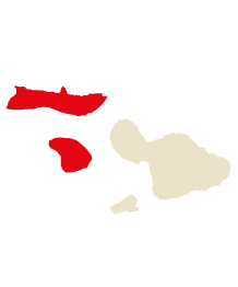
Lanaʻi & Moloka‘i
Lanai & Molokai Highlights
Lanai
Lanai City
Hulopoe & Manele Bays
Keomuku Road
Kaunolu
Molokai
Kaunakakai
East Molokai
Central Molokai
Kalaupapa National Historical Park
West End
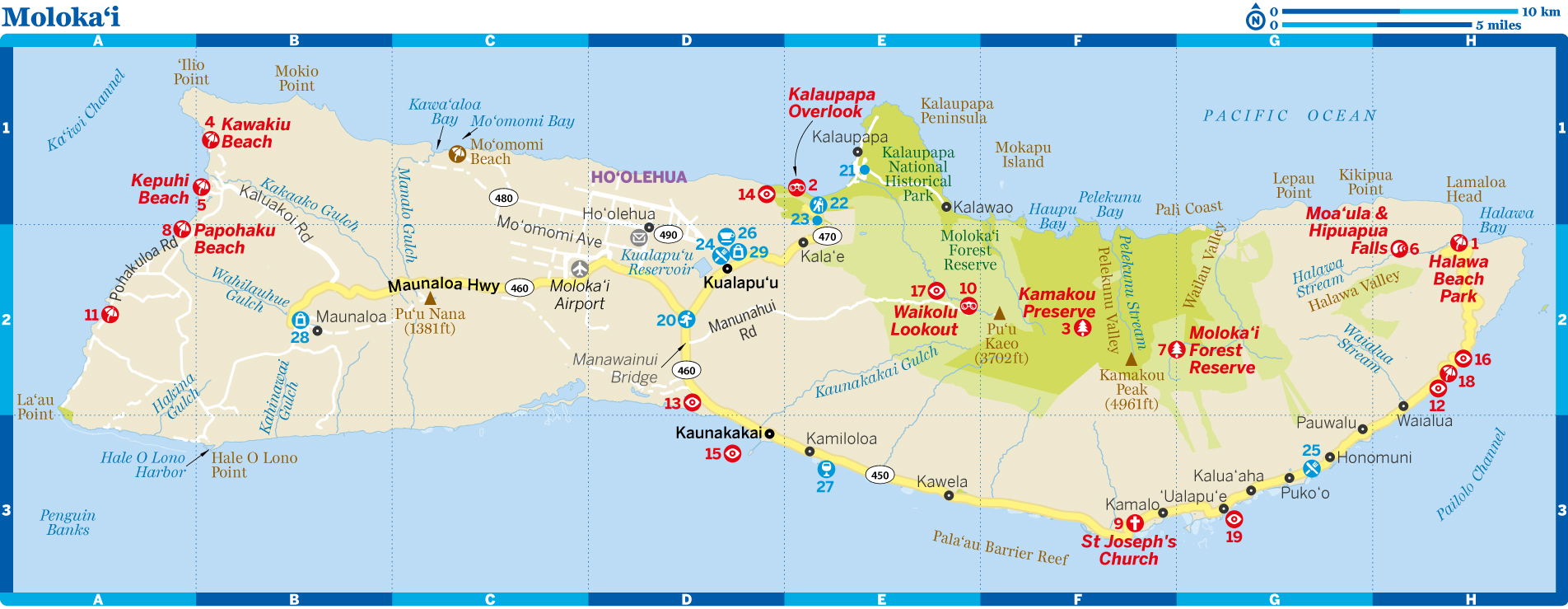
Lanaʻi & Moloka‘i
Why Go?
Among Hawaii’s six main islands, the two with the smallest populations and the least number of visitors could not be more different. Sure, Lana‘i and Molokaʻi are easily seen from the other across the narrow channel that separates them, but that’s where any similarities stop.
Lana‘i was never home to many people – its most active time in history was fairly recently when it fully earned its moniker ‘the pineapple island’ as much of it was given over to cultivation of the spiky fruit. Today, under the ownership of billionaire Larry Ellison, it offers a very low-key island escape from islands that are already an escape.
Moloka‘i is a much more varied place. It has a strong cultural past, with many ancient Hawaiian sites and a strong and, at times, almost militant reverence for its heritage. It has great and rugged natural beauty, but remains off the radar for most travelers.
When to Go
Nov–Mar Jackets are needed at night in lofty, temperate Lanaʻi City, while east Moloka‘i gets very rainy. Beaches stay balmy.
Apr–Aug Winter rains have stopped and the islands enjoy breezy tropical comfort.
Sep–Oct Lanaʻi City and central Moloka‘i stay in the sunny 70s (°F), while the coasts are in the lovely low 80s.
Best Places to Eat
A Nobu
Lanaʻi & Moloka‘i Highlights
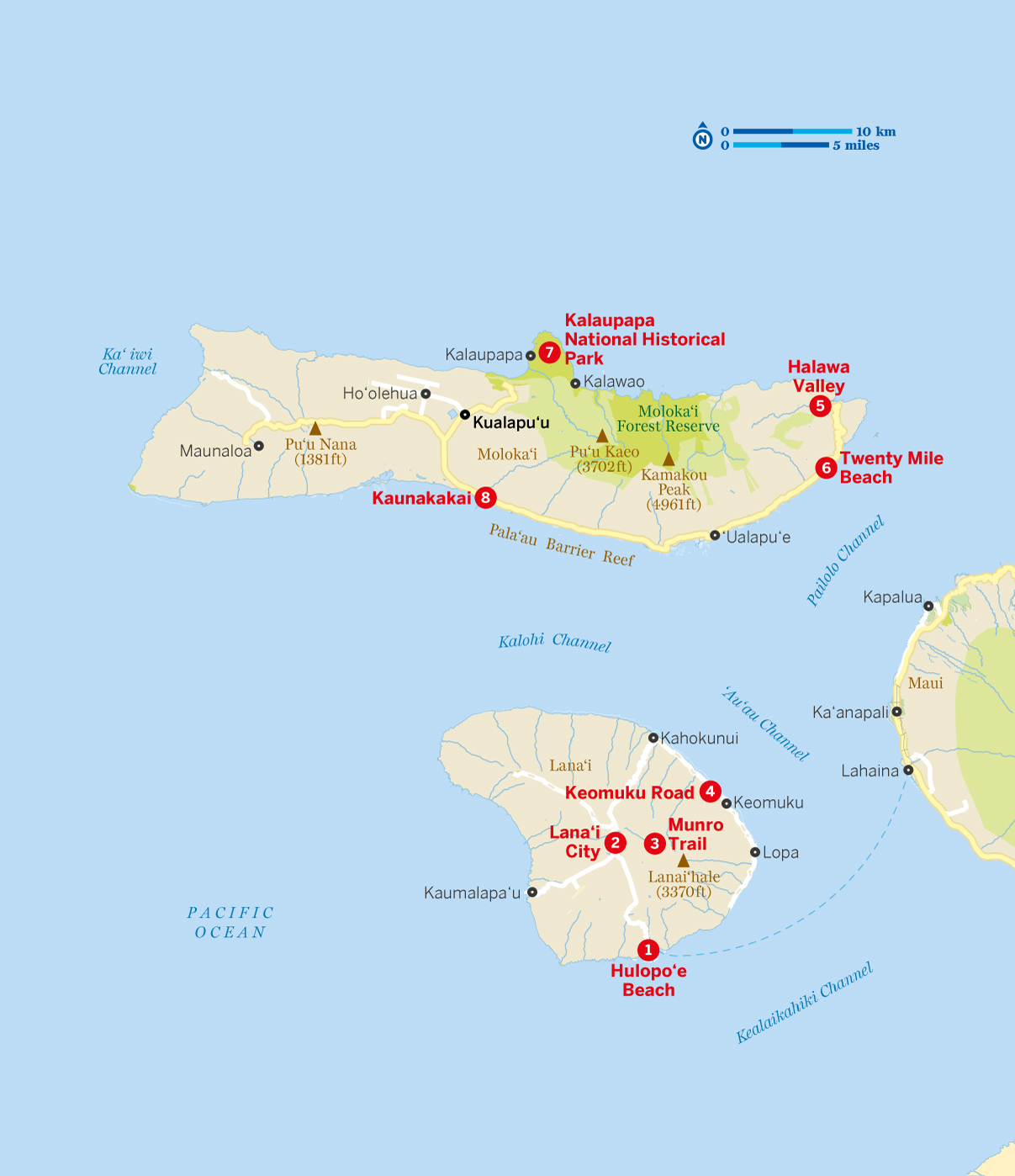
1 Hulopoʻe Beach Snorkeling the protected reef at the island's best beach.
2 Lanaʻi City Browsing the shops, then sampling the simple cafes, before dozing off in Dole Park.
3 Munro Trail Hiking through Lana‘i's small but lush heart, stretching above Lanaʻi City.
4 Keomuku Road Getting lost on this unpaved track to Naha, where you'll find a ghost town and idyllic beaches awaiting discovery.
5 Halawa Valley Hearing echoes of Hawaii's past while hiking in this pristine and deeply spiritual setting of waterfalls.
6 Twenty Mile Beach Discovering underwater delights, or just lazing the day away.
7 Kalaupapa National Historical Park Following in the footsteps of America's first saint on the Kalaupapa Peninsula; getting there is half the fun.
8 Kaunakakai Reliving plantation Hawaii wandering Molokaʻi's unrefined and historic main town.
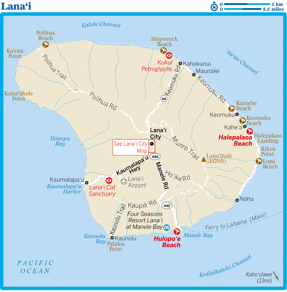
Lanaʻi
Although Lanaʻi is the most central of the Hawaii islands – on a clear day you can see five islands from here – it's also the least 'Hawaiian'. Now-closed pineapple plantations are its main historic legacy, and the locals are a mix of people descended from immigrant field workers from around the world.
Its signature (imported) Norfolk and Cook Island pines give the island a feel that could just as well come from a remote corner of the South Pacific. And therein lies the charm of Lanaʻi, a small island (at its widest point only 18 miles across) that's an off-the-beaten-path destination. Hidden beaches, archaeological sites, oddball geology and a sense of isolation let you get away from it all, without going far.
Of course, looming over Lana‘i is billionaire owner Larry Ellison, whose efforts to transform the island have proceeded in fits and starts.
LIFE WITH LARRY
Decades of sleepy seclusion for Lanaʻi were interrupted in 2012 when the fabulously wealthy cofounder of huge software developer Oracle, Larry Ellison, bought out the island's long-time owner Castle & Cooke (which once ran the ubiquitous pineapple plantations under the Dole name).
It's the biggest change to the island since Castle & Cooke stopped farming and built the Four Seasons resorts in the early 1990s. That the owner is a legendary hard-driving Silicon Valley entrepreneur known for, among other dramatics, winning the America's Cup twice (most recently in 2013), only adds to the interest.
For his estimated $600 million purchase price, Ellison got 98% of Lanaʻi (the rest is private homes or government land) and a bevy of businesses, such as the resorts. Given that the island has struggled economically since the glory days of pineapples, Ellison's wide-ranging plans for his trophy generated intense interest.
Under the guise of Pulama Lana‘i, the Ellison-owned company that manages the island, the changes have been many. Among the notable events are the following:
AConstruction projects to rebuild parts of the island infrastructure, enact beautification schemes and revitalize core businesses such as the Four Seasons Resort Lanaʻi put a major strain on the island. During 2016, both of the resorts were closed; the resulting dramatic downturn in visitors caused several long-running businesses to close.
AEllison has discovered that just because you own an island doesn't mean that you’re exempt from government regulations. Regulatory hurdles and local political opposition have delayed projects including a new beach resort at Halepalaoa. Issues surrounding approval for a desalination plant caused initiatives like a vast conference center to be put on hold.
ADuring 2016 and into 2017, there was a noticeable slowing in new proposals, leading many locals to fear that the political difficulties had caused Ellison to lose interest in the island and turn his famously high-intensity attentions elsewhere.
For residents, life on Lana‘i feels a bit like a soap opera as plans and schemes are floated and then forgotten. Ellison has said he wants the island to be economically self-sufficient, yet achieving this may be the biggest challenge of his life.
8Getting There & Around
Air
Lanaʻi Airport (LNY;
GOOGLE MAP
; ![]() %808-565-7942; http://hawaii.gov/lny; off Hwy 440) is about 3.5 miles southwest of Lanaʻi City. There are no direct flights to Lanaʻi from the mainland.
%808-565-7942; http://hawaii.gov/lny; off Hwy 440) is about 3.5 miles southwest of Lanaʻi City. There are no direct flights to Lanaʻi from the mainland.
Air service is limited to several flights a day on Ohana (![]() %800-367-5320; www.hawaiianairlines.com) linking Lana‘i to Honolulu. There is also usually one flight to/from Moloka‘i.
%800-367-5320; www.hawaiianairlines.com) linking Lana‘i to Honolulu. There is also usually one flight to/from Moloka‘i.
Boat
Worth it just for the ride, the Expeditions Maui–Lanaʻi Ferry (![]() %800-695-2624; www.go-lanai.com; adult/child 1 way $30/20) links Lahaina Harbor (Maui) with Manele Bay Harbor on Lanaʻi (one hour) several times daily. In winter there's a fair chance of seeing humpback whales; spinner dolphins are a common sight all year, especially on morning sails. Hulopoʻe Beach is near the dock; Lanaʻi tour and activity operators will meet the ferries if you call ahead. Day-trip packages from Maui are popular.
%800-695-2624; www.go-lanai.com; adult/child 1 way $30/20) links Lahaina Harbor (Maui) with Manele Bay Harbor on Lanaʻi (one hour) several times daily. In winter there's a fair chance of seeing humpback whales; spinner dolphins are a common sight all year, especially on morning sails. Hulopoʻe Beach is near the dock; Lanaʻi tour and activity operators will meet the ferries if you call ahead. Day-trip packages from Maui are popular.
Car
The island's only gas station, Lanaʻi City Service, sells pricey fuel – a hefty cost for the gas-guzzling rental fleets.
Most vehicle rentals on Lana‘i are pricey 4WDs, although these will be necessary for any real explorations.
The main car-rental outfit on the island is an affiliate of Dollar Rent-a-Car (
GOOGLE MAP
; ![]() %808-565-7227; http://dollarlanai.com; 1036 Lanaʻi Ave, Lanaʻi City; 4WD per day $140-200;
%808-565-7227; http://dollarlanai.com; 1036 Lanaʻi Ave, Lanaʻi City; 4WD per day $140-200; ![]() h7am-6pm); however, it's best to make your reservations direct with this office. Having a monopoly on Lanaʻi translates into steep prices: 4WD Jeeps are available. The firm is owned by Lanaʻi City Service; note the firm's numerous restrictions on where you can drive your 4WD; confirm these in advance to avoid hefty fines.
h7am-6pm); however, it's best to make your reservations direct with this office. Having a monopoly on Lanaʻi translates into steep prices: 4WD Jeeps are available. The firm is owned by Lanaʻi City Service; note the firm's numerous restrictions on where you can drive your 4WD; confirm these in advance to avoid hefty fines.
Alternatively, other small local firms may offer cheaper rates and allow you to drive to more parts of the island. Most can arrange for pick-up and drop-off at any place on the island. ABB Executive Rentals (![]() %808-649-0644; per day $125-180) offers 4WDs and a 2WD car and will arrange pick-up and drop-off. Lanaʻi Cheap Jeeps (
%808-649-0644; per day $125-180) offers 4WDs and a 2WD car and will arrange pick-up and drop-off. Lanaʻi Cheap Jeeps (![]() %808-649-9517; www.lanaicheapjeeps.com; per day $125-165) rents 4WD Jeeps and Subarus.
%808-649-9517; www.lanaicheapjeeps.com; per day $125-165) rents 4WD Jeeps and Subarus.
Taxi
Rabaca's Limousine (![]() %808-565-6670; rabacalimousine@gmail.com; single ride $10) offers point-to-point rides between the main areas of the island, including the airport. Custom trips to far-flung parts of the island and specialized tours are also available.
%808-565-6670; rabacalimousine@gmail.com; single ride $10) offers point-to-point rides between the main areas of the island, including the airport. Custom trips to far-flung parts of the island and specialized tours are also available.
Lanaʻi City
Lanaʻi City's main square, Dole Park, is surrounded by tin-roofed houses and shops, with not a chain in sight. The architecture is little changed since the plantation days of the 1920s, although the gardening is much improved thanks to the efforts of Ellison's island management company, Pulama Lana‘i. (Pulama means to care for or cherish.)
Wander between the small but delightfully varied collection of eateries and shops, all with a low-key appeal not found in more touristed places.

Lana‘i City
1Top Sights
1Sights
![]() oLanaʻi Culture & Heritage CenterMUSEUM
oLanaʻi Culture & Heritage CenterMUSEUM
(
MAP
GOOGLE MAP
; www.lanaichc.org; 111 Lanaʻi Ave; ![]() h8:30am-3:30pm Mon-Fri, 9am-1pm Sat)
h8:30am-3:30pm Mon-Fri, 9am-1pm Sat)![]() F
F
This engaging small museum has displays covering Lana‘i's often mysterious history; photos and a timeline show its transformation into the world's pineapple supplier. The lives of the workers are shown in detail and facts such as this jaw-dropper abound: each worker was expected to plant up to 10,000 new pineapple plants per day.
A DAY TRIP TO LANAʻI
Take the early morning ferry from Lahaina on Maui; keep an eye out for schools of dolphins as the boat approaches Manele Bay. Catch the shuttle into Lanaʻi City and pour your own coffee for breakfast at Blue Ginger Café before strolling the town's shops and superb Culture & Heritage Center. In the afternoon, snorkel at Hulopoʻe Beach or dive at Manele Bay before heading back to Maui on the sunset ferry.
2Activities & Tours
Lanaʻi Surf School & Surf SafariSURFING
(![]() %808-649-0739; www.surfinglanai.com; 3hr surf lessons per person $200)
%808-649-0739; www.surfinglanai.com; 3hr surf lessons per person $200)
Lana'i native Nick Palumbo offers half-day surfing and stand-up paddleboard surfing (SUP) lessons (two-person minimum) at secluded spots. Surfboard and paddleboard rentals from $60 per day including delivery. It also rents boogie boards and kayaks.
![]() oRabaca’s ToursDRIVING
oRabaca’s ToursDRIVING
(![]() %808-565-6670; rabacalimousine@gmail.com; tour for 1-6 people from $95hr)
%808-565-6670; rabacalimousine@gmail.com; tour for 1-6 people from $95hr)
4WD tours of the island's key sights – many otherwise inaccessible – by an experienced and entertaining guide. Tours are a minimum of three hours. Book in advance.
zFestivals & Events
Pineapple FestivalCULTURAL
(
GOOGLE MAP
; www.lanaipineapplefestival.com; ![]() hearly Jul)
hearly Jul)
Lanaʻi's main bash, the Pineapple Festival, is held on or near July 4 and celebrates the island's pineapple past with games and live music at Dole Park (any pineapple you see is imported!).
5Eating
![]() oLana‘i Ohana Poke MarketHAWAIIAN$
oLana‘i Ohana Poke MarketHAWAIIAN$
(
MAP
GOOGLE MAP
; ![]() %808-559-6265; 834A Gay St; meals $8-12;
%808-559-6265; 834A Gay St; meals $8-12; ![]() h10:30am-1pm Mon-Fri)
h10:30am-1pm Mon-Fri)
Seating choices at this simple place are limited to picnic tables in the sun or shade. But the poke (cubed raw fish mixed with shōyu, sesame oil, salt, chili pepper, ‘inamona or other condiments) choices are myriad: spicy tuna, shrimp tempura and more. The raw, cubed fish is superbly fresh and the sauces are spot on. Go early because it closes when they sell out, which is often before 1pm.
Options include divine braised teriyaki beef and perfect mac salad. The coconut shrimp is irresistible.
Blue Ginger CaféCAFE$
(
MAP
GOOGLE MAP
; ![]() %808-565-6363; www.bluegingercafelanai.com; 409 7th St; mains $5-15;
%808-565-6363; www.bluegingercafelanai.com; 409 7th St; mains $5-15; ![]() h6am-8pm Thu-Mon, to 2pm Tue & Wed)
h6am-8pm Thu-Mon, to 2pm Tue & Wed)
Don't worry, all the care goes into the food, not the decor at this bare-bones diner, where you can serve yourself a cup of coffee, grab a newspaper, and settle back at a table outside, listening to the wind chimes. Muffins arrive warm from the bakery.
The long menu ranges from breakfasts and salads to burgers, delectable chicken katsu (deep-fried fillets) and more. It's been run by the same family for decades.
![]() oPele’s Other GardenITALIAN$$
oPele’s Other GardenITALIAN$$
(
MAP
GOOGLE MAP
; ![]() %808-565-9628; cnr 8th & Houston Sts; mains $10-25;
%808-565-9628; cnr 8th & Houston Sts; mains $10-25; ![]() hkitchen 11am-2pm Mon-Fri, 5-8pm Mon-Sat, drinks until 9pm)
hkitchen 11am-2pm Mon-Fri, 5-8pm Mon-Sat, drinks until 9pm)
More bistro than deli, this restored plantation house has tables inside and out. Owners Barb and Mark cook creative takes on Italian cuisine and serve up classic spaghetti and meatballs, crispy thin-crust pizza and some first-rate pesto. Salads are made with organic local greens; desserts are large.
There's a fine beer list with 12 brews on tap and a bar menu of snacks such as coconut shrimp. Specials are just that!
![]() oLanaʻi City GrilleFUSION$$$
oLanaʻi City GrilleFUSION$$$
(
MAP
GOOGLE MAP
; ![]() %808-565-7211; www.hotellanai.com; 828 Lanaʻi Ave, Hotel Lanaʻi; mains $28-45;
%808-565-7211; www.hotellanai.com; 828 Lanaʻi Ave, Hotel Lanaʻi; mains $28-45; ![]() h5-9pm Wed-Sun)
h5-9pm Wed-Sun)
Famed Maui chef Bev Gannon designed the menu at the charming restaurant within the Hotel Lanaʻi (
GOOGLE MAP
; ![]() %808-565-7211; www.hotellanai.com; 828 Lanaʻi Ave; r $174-224, cottage $254;
%808-565-7211; www.hotellanai.com; 828 Lanaʻi Ave; r $174-224, cottage $254; ![]() W). Sturdy 1930s schoolhouse furnishings give the wood-floored dining room a vintage air, while the menu combines fresh seafood with various meats in ways both familiar (a perfect rib-eye) and excellent (ahi poke tacos).
W). Sturdy 1930s schoolhouse furnishings give the wood-floored dining room a vintage air, while the menu combines fresh seafood with various meats in ways both familiar (a perfect rib-eye) and excellent (ahi poke tacos).
The bar draws local movers and shakers, pours a fine highball, has a great wine list and is often open until 11pm! On Friday nights there's live Hawaiian music. A recent expansion has added an enticing outdoor terrace.
7Shopping
![]() oMike Carroll GalleryART, BOOKS
oMike Carroll GalleryART, BOOKS
(
MAP
GOOGLE MAP
; ![]() %808-565-7122; www.mikecarrollgallery.com; cnr 7th & Koʻele Sts;
%808-565-7122; www.mikecarrollgallery.com; cnr 7th & Koʻele Sts; ![]() h10am-5:30pm Mon-Sat, 9am-2pm Sun)
h10am-5:30pm Mon-Sat, 9am-2pm Sun)
Art-lovers enjoy Mike Carroll Gallery, where you can find the eponymous owner either creating a new work or busy displaying the work of another artist. It's a good source for local books plus Asian antiques.
Lanaʻi Art CenterART
(
MAP
GOOGLE MAP
; ![]() %808-565-7503; www.lanaiart.org; cnr 7th & Houston Sts;
%808-565-7503; www.lanaiart.org; cnr 7th & Houston Sts; ![]() h10am-4pm Mon-Sat)
h10am-4pm Mon-Sat)
Staffed by local artist volunteers. You can choose from works in many mediums or learn how to create your own from the artists themselves. A great place to get very local recommendations.
8Information
Lanaʻi City ServiceGAS STATION
(
GOOGLE MAP
; ![]() %808-565-7227; 1036 Lanaʻi Ave;
%808-565-7227; 1036 Lanaʻi Ave; ![]() h6:30am-10pm)
h6:30am-10pm)
The island's one gas station; pricey.
Lanaʻi Community HospitalHOSPITAL
(
GOOGLE MAP
; ![]() %808-565-8450; 628 7th St;
%808-565-8450; 628 7th St; ![]() h24hr)
h24hr)
Offers emergency medical services.
Post OfficePOST
(
GOOGLE MAP
; ![]() %808-565-6517; 620 Jacaranda St;
%808-565-6517; 620 Jacaranda St; ![]() h9am-3pm Mon-Fri, 9:30-11:30am Sat)
h9am-3pm Mon-Fri, 9:30-11:30am Sat)
Lana‘i's post office.
CAT SANCTUARY
Easily Lana‘i's most idiosyncratic sight, the volunteer-run Lanaʻi Cat Sanctuary (
GOOGLE MAP
; ![]() %808-215-9066; http://lanaicatsanctuary.org; off Hwy 440;
%808-215-9066; http://lanaicatsanctuary.org; off Hwy 440; ![]() h10am-3pm) houses hundreds of feral and abandoned cats. The 3-acre fenced location on a former pineapple field is a feline playground. Visitors are welcomed and will fully discover the range of kitty personalities, from outgoing to standoffish. Donations are vital to buying food and otherwise caring for the cats.
h10am-3pm) houses hundreds of feral and abandoned cats. The 3-acre fenced location on a former pineapple field is a feline playground. Visitors are welcomed and will fully discover the range of kitty personalities, from outgoing to standoffish. Donations are vital to buying food and otherwise caring for the cats.
Hulopoʻe & Manele Bays
Lanaʻi's finest beach (and one of the best in Hawaii) is the golden crescent of sand at Hulopoʻe Bay. Enjoy snorkeling, walking to a fabled archaeological site or just relaxing in the shade of palms. Nearby, Manele Harbor provides a protected anchorage for sailboats, other small craft and the Maui ferry, just a 10-minute walk from Hulopoʻe Beach. Manele and Hulopoʻe Bays are part of a marine-life conservation district that prohibits the removal of coral and restricts many fishing activities.
rBeaches
![]() oHulopoʻe BeachBEACH
oHulopoʻe BeachBEACH
(
GOOGLE MAP
; off Hwy 440; ![]() c)
c)
The main beach on the island is kept looking beautiful thanks to the efforts of Panama Lanai‘s legions of groundskeepers. Everybody loves this free public beach – locals taking the kids for a swim, tourists on day trips from Maui and the many visitors who end up losing track of time here.
This gently curving golden-sand beach is long, broad and protected by a rocky point to the south. The Four Seasons resort (
GOOGLE MAP
; ![]() %808-565-2000; www.fourseasons.com/lanai; 1 Manele Bay Rd, off Hwy 440; r from $1000;
%808-565-2000; www.fourseasons.com/lanai; 1 Manele Bay Rd, off Hwy 440; r from $1000; ![]() a
a![]() i
i![]() W
W![]() s) sits on a low seaside terrace on the north side. But the beach is rarely crowded, except on weekends, when picnicking locals descend. Picnic tables shelter under palms and there are public restrooms with solar-heated showers. The ferry dock is an easy 10-minute walk.
s) sits on a low seaside terrace on the north side. But the beach is rarely crowded, except on weekends, when picnicking locals descend. Picnic tables shelter under palms and there are public restrooms with solar-heated showers. The ferry dock is an easy 10-minute walk.
For the best snorkeling, head to the left side of the bay, where there's an abundance of coral and reef fish. To the left, just beyond the sandy beach, you'll find a low lava shelf with tide pools worth exploring. Look for the protected shoreline splash pool, ideal for children.
Manele HarborHARBOR
( GOOGLE MAP ; off Hwy 440)
During the early 20th century, cattle were herded down to Manele Bay for shipment to Honolulu. These days the herds start in Maui, traveling on day trips to Lanaʻi on the ferry. There are a few picnic tables under a shelter and bathrooms here. If you see a huge sailing yacht, it may be Larry's.
1Sights & Activities
Puʻu PeheNATURAL FEATURE
( GOOGLE MAP )
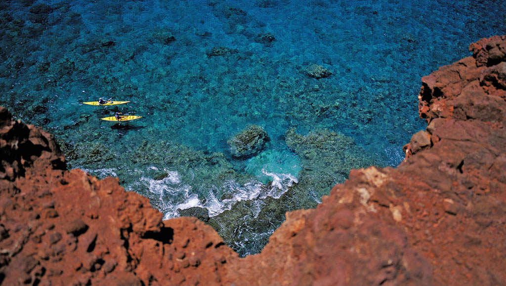
From Hulopoʻe Beach, a path (of around 0.75 miles) leads south to the end of Manele Point, which separates Hulopoʻe and Manele Bays. The point is actually a volcanic cinder cone that's sharply eroded on its seaward edge. The lava here has rich rust red colors with swirls of gray and black, and its texture is bubbly and brittle – so brittle that huge chunks of the point have broken off and fallen onto the coastal shelf below.
CathedralsDIVING
( GOOGLE MAP )
Diving in and around the bay is excellent. Coral is abundant near the cliffsides, where the bottom quickly slopes off to about 40ft. Beyond the bay's western edge, near Puʻu Pehe rock, is Cathedrals, the island's most spectacular dive site, featuring arches and grottoes amid a large lava tube that is 100ft in length.
Trilogy Lanaʻi Ocean Sports runs diving and snorkeling trips in the area.
![]() oKapihaʻa Village Interpretive TrailHIKING
oKapihaʻa Village Interpretive TrailHIKING
( GOOGLE MAP ; www.lanaichc.org/kapihaa.html; Four Seasons Resort Lana‘i)
This ancient trail makes for a fine and refreshing walk with superb coastal views. It begins on the coast just beneath the Four Seasons Resort Lana‘i; you'll see a sign as you walk up from the beach. Other signs point out history along the way. Download a guide from the website.
The trail is mostly flat, but dips down into gulches with wisps of beach, and gets very hot at midday. A spur leads to the site of an ancient village, Kapiha‘a, and on to the golf clubhouse.
Manele Golf CourseGOLF
(
GOOGLE MAP
; ![]() %808-565-2000; www.golfonlanai.com; Four Seasons Resort Lana‘i; greens fees $325;
%808-565-2000; www.golfonlanai.com; Four Seasons Resort Lana‘i; greens fees $325; ![]() h7:30am-6pm)
h7:30am-6pm)
This Jack Nicklaus–branded 7039yd course at the Four Seasons resort offers spectacular play along seaside cliffs. The 12th hole challenges golfers to hit across 200yd of ocean surf. It is open only to resort guests.
TTours
Trilogy Lanaʻi Ocean SportsWATER SPORTS
(![]() %808-874-5649; www.sailtrilogy.com; tours from $250)
%808-874-5649; www.sailtrilogy.com; tours from $250)
Runs diving and snorkeling trips around Lana‘i, including to the excellent Cathedrals dive site (from $450). On some trips snuba (a system where divers get their air by hose from the surface) is available. Trips use a sailing catamaran; some start on Maui, stopping at Lana‘i for pick-ups. Trips from Lana‘i cost much more than similar trips from Maui.
5Eating
Convenience StoreSUPERMARKET$
(
GOOGLE MAP
; Manele Harbor; lunches from $6; ![]() h7am-7pm)
h7am-7pm)
This much-needed small store on the harbor has all the basics plus locally prepared foods for lunch (think rice-based dishes you can heat in the microwave). You can buy your refreshments for the beach or the ferry ride here.
Views at Manele GolfAMERICAN$$
(
GOOGLE MAP
; ![]() %808-565-2000; www.fourseasons.com/manelebay; Four Seasons Resort Lanaʻi; mains $12-30;
%808-565-2000; www.fourseasons.com/manelebay; Four Seasons Resort Lanaʻi; mains $12-30; ![]() hkitchen 7am-3pm, bar only 3-6pm)
hkitchen 7am-3pm, bar only 3-6pm)
The fantastic coastal panorama from the private cliffside tables here is the best view from any island restaurant, and surprisingly little known. The menu has a broad array of familiar dishes such as salads, sandwiches and burgers; all are prepared with color and flair.
![]() oNobuJAPANESE$$$
oNobuJAPANESE$$$
(
GOOGLE MAP
; ![]() %808-565-2832; www.noburestaurants.com/lanai; off Hwy 440, Four Seasons Resort Lanaʻi; meals $50-200;
%808-565-2832; www.noburestaurants.com/lanai; off Hwy 440, Four Seasons Resort Lanaʻi; meals $50-200; ![]() hdinner 6-9:30pm, bar 4:30-10:30pm)
hdinner 6-9:30pm, bar 4:30-10:30pm)
The Four Seasons features a branch of the worldwide chain of vaunted high-end Japanese sushi restaurants that just happen to be favorites of Larry Ellison. Newly redesigned, the dining and bar area is on a broad, minimalist-yet-elegant terrace with superb views. The bar serves creative cocktails, including a fabulous sidecar.
One FortyAMERICAN$$$
(
GOOGLE MAP
; ![]() %808-565-2000; www.fourseasons.com/lanai/; Four Seasons Resort Lanaʻi; dinner mains $45-80;
%808-565-2000; www.fourseasons.com/lanai/; Four Seasons Resort Lanaʻi; dinner mains $45-80; ![]() h6:30-11am & 6-9pm)
h6:30-11am & 6-9pm)
Overlooking the ocean, this restaurant offers top-end steaks and fresh local seafood. The setting as the sun goes down is beautiful as you look past the flickering tiki torches and out across the bay. It also offers a bountiful breakfast buffet primarily enjoyed by resort guests.
Keomuku Road
The best drive on Lanaʻi, Keomuku Rd (Hwy 44) heads north from Lanaʻi City into cool upland hills, where fog drifts above grassy pastures. Along the way, impromptu overlooks offer straight-on views of the undeveloped southeast shore of Molokaʻi and its tiny islet Mokuhoʻoniki, in marked contrast to Maui's sawtooth high-rises in Kaʻanapali off to your right.
The 8-mile road gently slopes down to the coast in a series of switchbacks, through a mostly barren landscape punctuated by eccentrically shaped rocks. The paved road ends near the coast and you are in 4WD country. To the left, a dirt road leads to Shipwreck Beach, while turning right onto Keomuku Rd takes the adventurous to Keomuku Beach or all the way to Naha.
Keep your eyes open – sightings of wild mouflon sheep on the inland hills are not uncommon. Males have curled-back horns, and dominant ones travel with a harem. You may also see white-spotted axis deer.
Shipwreck Beach
Unlike many places worldwide named Shipwreck Beach, where the name seems fanciful at best, you can't miss the namesake wreck here. A large WWII tanker sits perched atop rocks just offshore. Unlike a metal ship (which would have dissolved decades ago), this one was part of a series made from concrete. It was dumped here by the Navy after the war.
Start your beach exploration by taking the sandy road that runs 1.4 miles north from the end of Hwy 44, past some beach shacks. Park in the large clearing overlooking a rocky cove which is known locally as Poʻaiwa and has good snorkeling among the rocks and reef, as well as protected swimming over the sandy bottom. The main beach runs north of here.
Kukui PetroglyphsHISTORIC SITE
( GOOGLE MAP )
From the lighthouse foundation, trail markings lead directly inland about 100yd to the Kukui petroglyphs, a cluster of fragile carvings marked by a sign reading 'Do Not Deface.' The simple figures are etched onto large boulders on the right side of the path.
Keomuku to Naha
Keomuku Rd from Kahokunui to Naha is just the journey for those looking for real adventure on Lanaʻi. Overhanging kiawe trees shade long stretches of the 12-mile dirt road, which varies from smooth to deeply cratered (and impossibly soupy after storms). This is where your 4WD will justify its daily fee, as you explore the ruins of failed dreams and discover magical beaches. If the road is passable, driving the entire length should take about an hour. The reef-protected shore is close to the road but usually not quite visible.
1Sights
![]() oHalepalaoa BeachBEACH
oHalepalaoa BeachBEACH
( GOOGLE MAP )
Running southeast from the pier at Halepalaoa Landing is the reef-protected and shaded Halepalaoa Beach, which seems to have come from desert-island central casting. In winter, the number of whales breaching offshore may outnumber the humans basking on the sand.
Halepalaoa LandingHISTORIC SITE
( GOOGLE MAP )
Just under 2 miles southeast along the road from Keomuku, you reach Halepalaoa Landing, from which the sugar company planned to ship out its product. But little was accomplished during its short life (1899–1901), other than to shorten the lives of scores of Japanese workers, who are buried in a small cemetery that has a sign reading 'Japanese Memorial Shrine'.
KeomukuHISTORIC SITE
( GOOGLE MAP )
The center of the short-lived sugarcane plantation, Keomuku is 6 miles southeast of Maunalei. The highlight is the beautifully reconstructed Ka Lanakila o Ka Malamalama Church, which was originally built in 1903.
MaunaleiHISTORIC SITE
Less than a mile from the end of paved Hwy 44 is Maunalei. An ancient heiau (stone temple) sat there until 1890, when the Maunalei Sugar Company dismantled it and used the stones to build a fence and railroad. Shortly after the temple desecration, the company was beset by misfortune, as saltwater filled the wells and disease decimated the workforce.
NahaHISTORIC SITE
( GOOGLE MAP )
Four miles south of Halepalaoa you come to Naha, which is both the end of the road and the site of ancient fishponds just offshore. With the wind whistling in your ears, this is a dramatic and desolate setting where the modern world seems very far away.
WORTH A TRIP
THE GARDEN OF THE GODS
The only fertilizer that might work in this garden is cement. Often weirdly shaped volcanic rocks are strewn about this seemingly martian landscape. Multihued rocks and earth, with a palette from amber to rust to sienna, are stunning.
It's utterly silent up here and you can see up to four other islands across the white-capped waters. The colors change with the light – pastel in the early morning, rich hues in the late afternoon.
Reached via the unpaved Polihua Rd, the stretch leading to the Garden of the Gods is fairly good, although often dusty. It generally takes about 30 minutes from town. Polihua Road starts near the stables at the Lodge at Koele.
Kaunolu
Perched on a majestic bluff at the southwestern tip of the island, the ancient fishing village of Kaunolu thrived until its abandonment in the mid-19th century after missionary-transmitted disease had ravaged the island's population. Now a registered National Historic Landmark, Kaunolu boasts the largest concentration of stone ruins on Lanaʻi, including Halulu Heiau. The temple once served as a puʻuhonua (place of refuge), where taboo-breakers fled to elude their death sentences. There are over 100 building sites here.
Northwest of the heiau (ancient stone temple), a natural stone wall runs along the perimeter of the sea cliff. Look for a break in the wall at the cliff's edge, where there's a sheer 63ft drop known as Kahekili's Jump. The ledge below makes diving into the ocean a death-defying thrill, but is recommended for professionals only. It's said that Kamehameha the Great would test the courage of upstart warriors by having them leap from this spot.
To reach little-visited Kaunolu, follow Kaumalapaʻu Hwy (Hwy 440) 0.6 miles past the airport, and turn left onto a partial gravel and dirt road that runs south through abandoned pineapple fields for 2.2 miles. A carved stone marks the turn onto a much rougher but still 4WD-capable road down to the sea. After a further 2.5 miles you'll see a sign for a short interpretive trail, which has well-weathered signs explaining the history of Kaunolu. Another 0.3 miles brings you to a parking area amid the ruins.
Moloka‘i
The popular local T-shirt proclaiming 'Molokaʻi time is when I want to show up' sums up this idiosyncratic island perfectly: feisty and independent, while not taking life too seriously. The moniker 'Friendly Isle' means slowing waaay down and taking your sense of rhythm from the locals.
Molokaʻi is often cited as the 'most Hawaiian' of the islands, and in terms of bloodlines this is true – more than 50% of the residents are at least part Native Hawaiian. But whether the island fits your idea of 'most Hawaiian' depends on your definition. If your idea of Hawaii includes great tourist facilities, forget it.
But if you're after a place that best celebrates the islands' geography and indigenous culture, then Molokaʻi is for you. Ancient Hawaiian sites in the island's beautiful tropical east are jealously protected and restored, and island-wide consensus eschews development of the often sacred west.
Moloka‘i
1Top Sights
1Sights
2Activities, Courses & Tours
8Getting There & Around
The Maui ferry no longer runs.
Renting a car is essential if you intend to explore the island or if you are renting a house or condo and will need to shop. All of Molokaʻi's highways and primary routes are good, paved roads. The free tourist map, widely available on the island, is useful.
Air
A taxi from the airport costs around $30 to Kaunakakai. Hele Mai Taxi (![]() %808-336-0967; www.molokaitaxi.com) services the island. Many accommodations can arrange transfers.
%808-336-0967; www.molokaitaxi.com) services the island. Many accommodations can arrange transfers.
Molokaʻi Airport (MKK, Hoʻolehua;
GOOGLE MAP
; ![]() %808-567-9660; http://hawaii.gov/mkk; Hoʻolehua) Small: you claim your baggage on a long bench. Single-engine planes are the norm; sit right behind the cockpit area for spectacular views forward. Because of weight limits for individual bags (40lb), pack a small duffel bag in case you have to redistribute your belongings.
%808-567-9660; http://hawaii.gov/mkk; Hoʻolehua) Small: you claim your baggage on a long bench. Single-engine planes are the norm; sit right behind the cockpit area for spectacular views forward. Because of weight limits for individual bags (40lb), pack a small duffel bag in case you have to redistribute your belongings.
Makani Kai Air (![]() %808-834-1111, 877-255-8532; http://makanikaiair.com) Offers scheduled and charter flights to Kalaupapa plus Honolulu (its fares on this route are often the cheapest).
%808-834-1111, 877-255-8532; http://makanikaiair.com) Offers scheduled and charter flights to Kalaupapa plus Honolulu (its fares on this route are often the cheapest).
Mokulele Airlines (![]() %866-260-7070; www.mokuleleairlines.com) Has frequent services to Honolulu and Maui, flights from Moloka‘i don't require security checks.
%866-260-7070; www.mokuleleairlines.com) Has frequent services to Honolulu and Maui, flights from Moloka‘i don't require security checks.
Ohana (![]() %800-367-5320; www.hawaiianairlines.com) The commuter carrier of Hawaiian Airlines serves Honolulu, Lana‘i and Maui from Molokaʻi.
%800-367-5320; www.hawaiianairlines.com) The commuter carrier of Hawaiian Airlines serves Honolulu, Lana‘i and Maui from Molokaʻi.
Bus
MEO Bus (![]() %808-553-3216; www.meoinc.org; bus trips free;
%808-553-3216; www.meoinc.org; bus trips free; ![]() hMon-Fri), a government economic development service, runs a free shuttle bus around Molokaʻi, roughly from 6am to 4pm. From a stop by Misaki's market in Kaunakakai routes go east past the Hotel Molokaʻi to Pukoʻo at mile marker 16, west to Maunaloa via the airport and to Kualapu‘u. The buses run roughly every two hours but it is essential that you confirm all details in advance and with the driver if you are hoping to make a round-trip. Stops are not marked.
hMon-Fri), a government economic development service, runs a free shuttle bus around Molokaʻi, roughly from 6am to 4pm. From a stop by Misaki's market in Kaunakakai routes go east past the Hotel Molokaʻi to Pukoʻo at mile marker 16, west to Maunaloa via the airport and to Kualapu‘u. The buses run roughly every two hours but it is essential that you confirm all details in advance and with the driver if you are hoping to make a round-trip. Stops are not marked.
Car
Most rental cars are technically not allowed on unpaved roads. If you intend to explore remote areas, such as the Kamakou Preserve, you'll need a vehicle with high clearance, probably a 4WD. Book well in advance, especially if planning a weekend visit. But if you're feeling lucky in low season, walk-in rates at the airport can be half those found online.
There are two gas stations in Kaunakakai. Expect sticker shock.
Alamo Rental Car ( GOOGLE MAP ; www.alamo.com; Moloka‘i Airport, Hoʻolehua) has a desk at the airport; reserve well in advance. The main office is just across the small parking area.
Local outfits often have the lowest rates. Mobettah Car Rentals (![]() %808-308-9566; www.mobettahcarrentals.com; car & SUV rental per week $340) offers cheap weekly rates on cars; it arranges pick-ups and drop-offs at the airport. Molokai Car Rental (
GOOGLE MAP
;
%808-308-9566; www.mobettahcarrentals.com; car & SUV rental per week $340) offers cheap weekly rates on cars; it arranges pick-ups and drop-offs at the airport. Molokai Car Rental (
GOOGLE MAP
; ![]() %808-336-0670; www.molokaicars.com; 109 Ala Malama Ave, Kaunakakai; car rental per day from $45;
%808-336-0670; www.molokaicars.com; 109 Ala Malama Ave, Kaunakakai; car rental per day from $45; ![]() h9am-3pm Mon-Fri, to noon Sat) is a small local firm with a limited selection of cars and vans.
h9am-3pm Mon-Fri, to noon Sat) is a small local firm with a limited selection of cars and vans.
Kaunakakai
View a photo of Molokaʻi's main town from 50 years ago and the main drag won't look much different from today. Worn wood-fronted buildings with tin roofs that roar in the rain seem like refugees from a Clint Eastwood western. But there's no artifice to Kaunakakai – it's the real deal. All of the island's commercial activities are here and you'll visit often – if nothing else, for its shops and services.

Kaunakakai
5Eating
6Drinking & Nightlife
1Sights
Kaunakakai WharfPORT
( MAP GOOGLE MAP ; Kaunakakai Pl)
The busy commercial lifeline for Molokaʻi. OK, it's not that busy… A freight barge chugs in, skippers unload catches of mahimahi (white-fleshed fish also called 'dolphin') and a buff gal practices for a canoe race. A roped-off area with a floating dock provides a kids' swim area.
Kapuaʻiwa Coconut GroveHISTORIC SITE
( MAP GOOGLE MAP ; Maunaloa Hwy)
As Molokaʻi was the favorite island playground of King Kamehameha V, he had the royal 10-acre Kapuaʻiwa Coconut Grove planted near his sacred bathing pools in the 1860s. Standing tall, about a mile west of downtown, its name means 'mysterious taboo.' Be careful where you walk (or park) when you visit, because coconuts frequently plunge silently to the ground, landing with a deadly thump.
2Activities
![]() oMolokaʻi BicycleCYCLING
oMolokaʻi BicycleCYCLING
(
MAP
GOOGLE MAP
; ![]() %808-553-5740; www.mauimolokaibicycle.com; 80 Mohala St, Kaunakakai; bike rental per day/week from $25/75;
%808-553-5740; www.mauimolokaibicycle.com; 80 Mohala St, Kaunakakai; bike rental per day/week from $25/75; ![]() h3-6pm Wed, 9am-2pm Sat & by appointment)
h3-6pm Wed, 9am-2pm Sat & by appointment)
This shop's owner, Phillip Kikukawa, has a great depth of knowledge about cycling across the breadth of the island. He'll do pick-ups and drop-offs outside his opening hours. As well as offering repairs, parts and sales, there is a wide selection of bikes to rent, including mountain bikes. Prices include helmet, lock, pump, maps and much more.
Beach Break Moloka‘iOUTDOORS
(
MAP
GOOGLE MAP
; ![]() %808-567-6091; Holomua Jct, cnr Hwys 460 & 470;
%808-567-6091; Holomua Jct, cnr Hwys 460 & 470; ![]() h10am-4pm Mon-Sat)
h10am-4pm Mon-Sat)
Offers a wide range of surf gear for sale. Surfboard rentals start at $20 per day and there are many kinds available, including stand-up paddleboards (SUPs). Snorkeling sets are $10 per day, and you can also rent beach gear including chairs, coolers and umbrellas. Sale items include yoga mats.
TTours
![]() oMolokaʻi OutdoorsOUTDOORS
oMolokaʻi OutdoorsOUTDOORS
(![]() %877-553-4477, 808-553-4477; www.molokai-outdoors.com; SUP/kayak tour adult/child from $68/35, 7-8hr island tour $166/87;
%877-553-4477, 808-553-4477; www.molokai-outdoors.com; SUP/kayak tour adult/child from $68/35, 7-8hr island tour $166/87; ![]() hhours vary)
hhours vary)
Molokaʻi Outdoors can custom-design adventures and arrange activities. Paddling and SUPs are its specialty and it can also arrange tours across the island. Kayak and SUP rentals (from $42 per day) can also include transport and pick-ups across the island (from $35).
![]() oWalter NakiCULTURAL TOUR, BOAT TOUR
oWalter NakiCULTURAL TOUR, BOAT TOUR
(Molokai Action Adventures; ![]() %808-558-8184)
%808-558-8184)
Walter Naki, who is also known for his cultural tours and treks, offers deep-sea fishing, whale-watching and highly recommended North Shore boat tours that include the Pali Coast. Prices negotiable.
Molokaʻi Fish & DiveOUTDOORS
(
MAP
GOOGLE MAP
; ![]() %808-553-5926; www.molokaifishanddive.com; Ala Malama Ave, Kaunakakai; 2-tank boat dives incl equipment $165;
%808-553-5926; www.molokaifishanddive.com; Ala Malama Ave, Kaunakakai; 2-tank boat dives incl equipment $165; ![]() h6am-7pm)
h6am-7pm)
This is really the Big Kahuna of activities on the island. It operates fishing trips and rents gear. If you have a vague notion of something you'd like to do, come here and see what staff advise. It has a range of beach accessories such as chairs ($5) and umbrellas ($4).
zFestivals & Events
Ka Molokaʻi MakahikiCULTURAL
(Kaunakakai; ![]() hlate Jan)
hlate Jan)
The ancient makahiki festival, held after the year's main harvest was complete, is still celebrated on Moloka‘i. It features traditional ceremonies, an Olympics-esque competition of ancient Hawaiian sports, as well as crafts and activities.
Molokaʻi Ka Hula PikoCULTURAL
(www.kahulapiko.com; ![]() hMay or Jun)
hMay or Jun)![]() F
F
As Molokaʻi is known as the birthplace of hula, its three-day hula festival has some profound roots. It opens with a solemn ceremony at 3am at Puʻu Nana (the site of Hawaii's first hula school), followed by a festival including performance, food and crafts. Confirm the dates in advance.
5Eating
![]() oMaka’s KornerCAFE$
oMaka’s KornerCAFE$
(
MAP
GOOGLE MAP
; ![]() %808-553-8058; cnr Mohala & Alohi Sts; meals $5-10;
%808-553-8058; cnr Mohala & Alohi Sts; meals $5-10; ![]() h7am-9pm Mon-Fri, 8am-1pm Sat & Sun)
h7am-9pm Mon-Fri, 8am-1pm Sat & Sun)
A dead-simple corner location belies the fine yet basic fare here. Molokaʻi's best burgers come with excellent fries, although many patrons are simply addicted to the mahimahi (white-fleshed fish also called ‘dolphin’) sandwich (go nuts and order it dressed with two shrimp tempura). Pancakes are served throughout the day. Sit at the tiny counter or at a picnic table outside.
Molokaʻi BurgerBURGERS$
(
MAP
GOOGLE MAP
; ![]() %808-553-3533; www.molokaiburger.com; 20 Kamehameha V Hwy; mains $5-10;
%808-553-3533; www.molokaiburger.com; 20 Kamehameha V Hwy; mains $5-10; ![]() h7am-9pm;
h7am-9pm; ![]() W)
W)
Moloka‘i's only drive-through restaurant is a slick operation. The burgers come in many forms but are all thick and juicy. (Try a ramen burger, which is sandwiched between squares of fried noodles.) The dining room is inoffensive; the front terrace peacefully shady. Soft-serve ice cream is a treat.
Kanemitsu BakeryBAKERY$
(
MAP
GOOGLE MAP
; ![]() %808-553-5855; 79 Ala Malama Ave; loaf of bread $5;
%808-553-5855; 79 Ala Malama Ave; loaf of bread $5; ![]() h5:30am-5pm Wed-Mon, hot bread 7:30am-11pm Tue-Sun)
h5:30am-5pm Wed-Mon, hot bread 7:30am-11pm Tue-Sun)
Known for its Molokaʻi sweet bread and crackers (the macadamia-nut ones are extraordinary). Otherwise, you'll be surprised such good fresh-baked stuff can come from such a low place. Note: the best stuff is usually gone by 1pm.
Friendly MarketSUPERMARKET$
(
MAP
GOOGLE MAP
; ![]() %808-553-5595; 90 Ala Malama Ave;
%808-553-5595; 90 Ala Malama Ave; ![]() h8:30am-8:30pm Mon-Fri, to 6:30pm Sat)
h8:30am-8:30pm Mon-Fri, to 6:30pm Sat)
The best selection of any supermarket on the island. In the afternoon fresh seafood from the wharf often appears.
Molokaʻi Pizza CafePIZZA$
(
MAP
GOOGLE MAP
; ![]() %808-553-3288; Kaunakakai Pl; meals $9-18;
%808-553-3288; Kaunakakai Pl; meals $9-18; ![]() h10am-10pm Mon-Thu, to 11pm Fri & Sat, 11am-10pm Sun)
h10am-10pm Mon-Thu, to 11pm Fri & Sat, 11am-10pm Sun)
Order at the counter or have a seat in the starkly lit dining area at this pizza joint offering everything from salad and sub sandwiches to burgers and pasta. Lazy cooks can get their pizza half-baked (it's neither thick, thin, nor even just right) and finish cooking it in their rental unit.
6Drinking & Nightlife
![]() oHale KealohaLOUNGE
oHale KealohaLOUNGE
(
MAP
GOOGLE MAP
; ![]() %808-553-5347; Kamehameha V Hwy, Hotel Molokaʻi; mains $15-25;
%808-553-5347; Kamehameha V Hwy, Hotel Molokaʻi; mains $15-25; ![]() h7am-9pm)
h7am-9pm)
The Hotel Molokaʻi's simple waterfront bar and restaurant has waterfront views and skippable food. However the don't-miss highlight are the local kapuna (elders) who gather at a long table to play Hawaiian music on 'Aloha Fridays' from 4pm to 6pm. The music always draws a crowd; the performers range from those with some languid and traditional hula moves to jam sessions with a ukulele.
It's a true community gathering with some of the people who are the heart and soul of local culture and who delight in showing off their traditional talents. Don't miss.
Paddler’s InnPUB
(
MAP
GOOGLE MAP
; ![]() %808-553-3300; www.molokaipaddlersinn.com; 10 Mohala St; mains $8-20;
%808-553-3300; www.molokaipaddlersinn.com; 10 Mohala St; mains $8-20; ![]() h8am-1am;
h8am-1am; ![]() W)
W)
The island's only real pub has a large outside terrace that makes up in cheer what it lacks in charm. The long menu is served until about 9pm. Regular items include deep-fried pub grub, burgers, steaks and simple pastas; however, there are many specials on various theme nights. Watch for live performances by local musicians many nights.
7Shopping
![]() oKalele Bookstore & Divine ExpressionsBOOKS
oKalele Bookstore & Divine ExpressionsBOOKS
(
MAP
GOOGLE MAP
; ![]() %808-553-5112; http://molokaispirit.com; 64 Ala Malama Ave;
%808-553-5112; http://molokaispirit.com; 64 Ala Malama Ave; ![]() h10am-5pm Mon-Fri, 9am-2pm Sat;
h10am-5pm Mon-Fri, 9am-2pm Sat; ![]() W)
W)
New and used books, local artworks and loads of local culture and travel advice. Few locals walk past without dropping in to say hi.
Molokaʻi Art from the HeartART
(
MAP
GOOGLE MAP
; ![]() %808-553-8018; http://molokaigallery.com; 64 Ala Malama Ave;
%808-553-8018; http://molokaigallery.com; 64 Ala Malama Ave; ![]() h9:30am-5pm Mon-Fri, 9am-2:30pm Sat)
h9:30am-5pm Mon-Fri, 9am-2:30pm Sat)
Run by local artists, this small shop is packed with arts and crafts. Works in all mediums can be found here; quality ranges from the earnest to the superb. The T-shirts with local sayings are the real sleepers in the souvenir department.
Saturday Morning MarketMARKET
(
MAP
GOOGLE MAP
; Ala Malama Ave; ![]() h8am-2pm Sat)
h8am-2pm Sat)
This weekly market at the west end of Ala Malama Ave is the place to browse local crafts, try new fruits, stock up on organic produce and pick up some flowers. You'll find most of Molokaʻi here before noon.
8Information
Bank of HawaiiBANK
(
GOOGLE MAP
; www.boh.com; Ala Malama Ave; ![]() h8:30am-1pm & 2-4pm Mon-Thu, to 6pm Fri, ATM 24hr)
h8:30am-1pm & 2-4pm Mon-Thu, to 6pm Fri, ATM 24hr)
Has one of several 24-hour ATMs in town.
Molokaʻi General HospitalHOSPITAL
(
GOOGLE MAP
; ![]() %808-553-5331; www.molokaigeneralhospital.org; 280 Homeolu Pl;
%808-553-5331; www.molokaigeneralhospital.org; 280 Homeolu Pl; ![]() h24hr)
h24hr)
Emergency services.
Molokaʻi Visitors AssociationTOURIST INFORMATION
(MVA;
GOOGLE MAP
; ![]() %808-553-3876; www.gohawaii.com/molokai; 2 Kamoi St;
%808-553-3876; www.gohawaii.com/molokai; 2 Kamoi St; ![]() h9am-3pm Mon-Fri)
h9am-3pm Mon-Fri)
This simple office can help with info about member businesses. Look for events updates at www.facebook.com/MolokaiVisitorsAssociation.
8Getting There & Away
Kaunakakai is a walking town. Rawlin's Chevron (
GOOGLE MAP
; cnr Maunaloa Hwy/Hwy 460 & Ala Malama Ave; ![]() hoffice 6:30am-8:30pm Mon-Sat, 7am-6pm Sun) has credit-card-operated pumps, making it the only round-the-clock gas station on the island.
hoffice 6:30am-8:30pm Mon-Sat, 7am-6pm Sun) has credit-card-operated pumps, making it the only round-the-clock gas station on the island.
East Molokaʻi
The oft-quoted road sign 'Slow down, this is Molokaʻi' really applies as you head east on the 27-mile drive on Hwy 450 (aka Kamehameha V Hwy) from Kaunakakai to the Halawa Valley.
Unlike the arid west, this is tropical Molokaʻi, with palm trees arching over the road. You'll also catch glimpses of ancient fishponds, stoic old wooden churches, modest family homes, beaches and much more. And watch for dogs sleeping on the yellow line. The final climb up and over into the remote Halawa Valley is breathtaking.
Kawela to Kaluaʻaha
1Sights
![]() oSt Joseph’s ChurchCHURCH
oSt Joseph’s ChurchCHURCH
( MAP GOOGLE MAP ; Hwy 450)
Only two of the four Moloka‘i churches that missionary and prospective saint Father Damien built outside of the Kalaupapa Peninsula are still standing. One of them is quaint little St Joseph's Church (the other is Our Lady of Seven Sorrows). This simple, one-room wooden church, dating from 1876, has a steeple and a bell, five rows of pews and some of the original wavy glass panes. It's just past mile marker 10. The door is usually open.
There is also a lei-draped statue of Father Damien and a little cemetery beside the church.
ʻUalapuʻe FishpondHISTORIC SITE
( MAP GOOGLE MAP ; Hwy 450)
A half-mile beyond Wavecrest Resort condo development, at mile marker 13, you'll spot ʻUalapuʻe Fishpond on the makai (seaward) side of the road. This fishpond, which is a National Historic Landmark, has been restored and restocked with mullet and milkfish, two species that were raised here in ancient times. It's a good place to ponder the labor involved in moving these thousands of large volcanic rocks.
FISHPONDS
Starting just east of Kaunakakai and continuing past mile marker 20 along Hwy 450 are dozens of loko iʻa (fishponds), huge circular walls of rocks that are part of one of the world's most advanced forms of aquaculture. Monumental in size, backbreaking in creation, the fishponds operate on a simple principle: little fish swim in, big fish can't swim out. Some of the ponds are obscured and overgrown by mangroves, but others have been restored by locals anxious to preserve this link to their past. The Kahinapohaku Fishpond, about half a mile past mile marker 19, is in excellent shape. Another good one is ʻUalapuʻe Fishpond at mile marker 13.
Pukoʻo to Rock Point
Pukoʻo was once the seat of local government (complete with a courthouse, jail, wharf and post office), but the center of island life shifted to Kaunakakai when the plantation folks built that more centrally located town. Nowadays, Pukoʻo is a sleepy, slow-paced gathering of a few structures.
1Sights & Activities
Kahinapohaku FishpondHISTORIC SITE
( MAP GOOGLE MAP ; Hwy 450)
Ongoing restoration efforts have made this the premier fishpond on the island, tended by konohiki (caretakers) who live simply on site. You can see ancient fishing techniques in use today. It is a half-mile east of mile marker 19.
Twenty Mile BeachBEACH
(Murphy's Beach; MAP GOOGLE MAP ; Hwy 450)
Well protected by a reef, the curve of fine sand fronts a large lagoon that is great for snorkeling. Near shore there are rocks and the water can be very shallow, but work your way out and you'll be rewarded with schools of fish, living sponges, octopuses and much more.
Rock PointNATURAL FEATURE
( MAP GOOGLE MAP ; Hwy 450)
The pointy clutch of rocks sticking out, as the road swings left before the 21-mile marker, is called, appropriately enough, Rock Point. This popular surf spot is the site of local competitions and it’s the place to go if you’re looking for east-end swells.
5Eating
The market attached to Manaʻe Goods & Grindz is small but well-stocked.
![]() oManaʻe Goods & GrindzHAWAIIAN$
oManaʻe Goods & GrindzHAWAIIAN$
(
MAP
GOOGLE MAP
; ![]() %808-558-8186; Hwy 450; meals $5-13;
%808-558-8186; Hwy 450; meals $5-13; ![]() hkitchen 6:30am-4pm daily, store 6:30am-6pm Mon-Fri, to 4pm Sat & Sun;
hkitchen 6:30am-4pm daily, store 6:30am-6pm Mon-Fri, to 4pm Sat & Sun; ![]() W)
W)
Even if it wasn't your only option, you'd still want to stop here. The plate lunches are something of a local legend: tender yet crispy chicken katsu (deep-fried fillets), specials such as pork stew, and standards such as excellent teriyaki burgers and fresh fish sandwiches served on perfectly grilled buns.
Halawa Valley
With stunningly gorgeous scenery, Halawa Valley enjoys end-of-the-road isolation, which residents guard jealously with gates and 'no trespassing' signs. It was an important settlement in precontact Molokaʻi, with a population of more than 1000 and a complex irrigation system.
As late as the mid-19th century, the fertile valley still had a population of about 500 and produced much of the island's taro. Due to past tsunamis, only a few families now remain.
rBeaches
![]() oHalawa Beach ParkBEACH
oHalawa Beach ParkBEACH
( MAP GOOGLE MAP )
Halawa Beach was a favored surfing spot for Molokaʻi chiefs and is popular today with local kids, although often you won't see a soul. The beach has double coves separated by a rocky outcrop, with the north side a bit more protected than the south.
When the water is calm, there's good swimming and folks launch sea kayaks here, but both coves are subject to dangerous rip currents when the surf is heavy.
Up from the beach, Halawa Beach Park has picnic pavilions, restrooms and nondrinkable running water. Throughout the valley, there's an eerie feel that you can't quite shake, as if the generations that came before aren't sure what to make of it all. Some locals aren't entirely welcoming to visitors.
TTours
There are hiking opportunities through the Halawa Valley to Moaʻula and Hipuapua Falls.
![]() oPilipo SolatarioGUIDE
oPilipo SolatarioGUIDE
(Halawa Valley Falls Cultural Hike; ![]() %808-542-1855, 808-551-1055; www.halawavalleymolokai.com; adult/child $60/35;
%808-542-1855, 808-551-1055; www.halawavalleymolokai.com; adult/child $60/35; ![]() hhikes most days 9am)
hhikes most days 9am)
Pilipo is a highly recommended guide who has lived most of his life in the Halawa Valley along with his family. He's an amazing storyteller and he regales guests with fascinating details of local culture. The actual hike is usually led by his son. Book well in advance.
Eddie TanakaHIKING
(![]() %808-658-0191, 808-558-8396; edward.tanaka@yahoo.com; hikes from $60)
%808-658-0191, 808-558-8396; edward.tanaka@yahoo.com; hikes from $60)
Local musician and Molokaʻi native Eddie Tanaka will customize a hike to Moaʻula and Hipuapua Falls. Be sure to spend extra time on culture and lore.
Central Molokaʻi
The western section of Central Molokaʻi takes in Moʻomomi Beach and the coffee-growing center of Kualapuʻu. To the east, the terrain rises sharply to the misty, ancient forests of Kamakou.
Molokaʻi's second-most-popular drive (after the Halawa Valley drive in the east) runs from Kualapuʻu up Hwy 470 to Palaʻau State Park, site of the Kalaupapa Overlook, where you'll find one of the island's most captivating views.
Kamakou Area
The best reason to rent a 4WD vehicle on Molokaʻi is for the views from the Waikolu Lookout before discovering the verdant mysteries of the Nature Conservancy's Kamakou Preserve, where you'll find the island's highest peaks. Exploring this secret side of Molokaʻi is pure adventure. Besides gazing down into two deep valleys on the island's stunning and impenetrable north coast, you'll explore a near-pristine rainforest that is home to more than 250 native plant species (more than 200 endemic) and some of Hawaii's rarest birds. Although you can't quite reach the island's highest point, Kamakou Peak (4961ft), you'll still get your head in the clouds.
1Sights
![]() oMolokaʻi Forest ReservePARK
oMolokaʻi Forest ReservePARK
( MAP GOOGLE MAP )
The 10-mile drive up to Waikolu Lookout ( MAP GOOGLE MAP ) takes about 45 minutes, depending on road conditions. You pass through open land with trees and scrubs that is technically the Molokaʻi Forest Reserve, although little is developed and signs are few. A mile before the lookout you’ll find the 19th-century Sandalwood Pit ( MAP GOOGLE MAP ), a grassy depression on the left.
![]() oKamakou PreservePARK
oKamakou PreservePARK
( MAP GOOGLE MAP )
Hiking back through three million years of evolution on the Pepeʻopae Trail is Kamakou’s star attraction. Crossed by a boardwalk, this undisturbed Hawaiian montane bog is a miniature primeval forest of stunted trees, dwarf plants and lichens that make it feel like it’s the dawn of time. From the trail’s end at Pelekunu Valley Overlook ( MAP GOOGLE MAP ; Kamakou Preserve), you’ll be rewarded with a fantastic view of majestic cliffs, and, if it’s not too cloudy, you’ll see the ocean beyond.
To reach the Pepeʻopae Trail from Waikolu Lookout, follow Kamakou’s main 4WD road 2.5 miles to the marked trailhead; this makes a nice hour-long forest walk in itself.
A great way to see Kamakou is by joining one of the guided hikes led by the Nature Conservancy (![]() %808-553-5236; www.nature.org/hawaii; donation requested;
%808-553-5236; www.nature.org/hawaii; donation requested; ![]() hMar-Oct) on the first or second Saturday of every month. Transportation is provided to and from the preserve.
hMar-Oct) on the first or second Saturday of every month. Transportation is provided to and from the preserve.
Kualapuʻu
Kualapuʻu is the name of both a 1017ft hill and a nearby village. The world's largest rubber-lined reservoir lies at the base of the hill. Its 1.4 billion gallons of water are piped in from the rainforests of eastern Molokaʻi and it is the only source of water for the Hoʻolehua Plains and the dry West End.
In the 1930s the headquarters of the Del Monte pineapple plantation were located here and a company town grew. Pineapples ruled for nearly 50 years, until Del Monte pulled out of Molokaʻi in 1982 and the economy crumbled.
5Eating & Drinking
![]() oKualapuʻu CookhouseHAWAIIAN$$
oKualapuʻu CookhouseHAWAIIAN$$
(Kamuela Cookhouse;
MAP
GOOGLE MAP
; ![]() %808-567-9655; Hwy 490; mains $6-33;
%808-567-9655; Hwy 490; mains $6-33; ![]() h7am-8pm Tue-Sat, 9am-2pm Sun, 7am-2pm Mon)
h7am-8pm Tue-Sat, 9am-2pm Sun, 7am-2pm Mon)
This old roadhouse serves good lunches and is the only place for a meal west of Kaunakakai. Breakfasts feature huge omelets while plate-lunch options include excellent pork tonkatsu (breaded and fried cutlets). The dinner menu is more ambitious and includes ribs, steak and spicy crusted ahi (yellowfin tuna). Beer and wine can be purchased at the grocery across the street. Service is endearing. Cash only.
Coffees of HawaiiCAFE
(
MAP
GOOGLE MAP
; ![]() %808-567-6830; www.coffeesofhawaii.com; cnr Hwys 470 & 490;
%808-567-6830; www.coffeesofhawaii.com; cnr Hwys 470 & 490; ![]() h7am-4pm Mon-Sat, to 2pm Sun;
h7am-4pm Mon-Sat, to 2pm Sun; ![]() W)
W)
Coffees of Hawaii grows and roasts its own coffee on small plots around its attractive and easily reached setting. You can survey the scene from the verandah and enjoy a cup of the local coffee and a snack.
7Shopping
Blue MonkeyGIFTS & SOUVENIRS
(
MAP
GOOGLE MAP
; ![]() %808-567-6776; www.bigwindkites.com/bluemonkey; cnr Hwys 470 & 490;
%808-567-6776; www.bigwindkites.com/bluemonkey; cnr Hwys 470 & 490; ![]() h10am-5pm Mon-Sat)
h10am-5pm Mon-Sat)
This large and colorful gift shop in the Coffees of Hawaii buildings offers an excellent selection of local goods and books.
Palaʻau State Park
1Sights
![]() oKalaupapa OverlookVIEWPOINT
oKalaupapa OverlookVIEWPOINT
( MAP GOOGLE MAP ; Pala‘au State Park)
The Kalaupapa Overlook provides a scenic overview of the Kalaupapa Peninsula from the edge of a 1600ft cliff. It's easy to get the lay of the land from up here and you'll get a good feel for just how far you'll travel if you descend the nearly 1700ft on the trail. Interpretive plaques identify significant landmarks below and explain Kalaupapa's history.
KauleonanahoaCULTURAL SITE
( MAP GOOGLE MAP ; Pala‘au State Park)
Kauleonanahoa (the penis of Nanahoa) is Hawaii's premier phallic stone, standing proud in a little clearing inside an ironwood grove, about a five-minute walk from the parking area. The legend goes that Nanahoa hit his wife Kawahuna in a jealous rage and, when they were both turned to stone, he came out looking like a dick, literally. (The stone has been modified through the years to emphasize its appearance.)
Reputedly, women who come here with offerings of lei and stay overnight will soon get pregnant. There's no mention of what happens to men who might try the same thing with some nearby stones that have been carved into a female counterpart to the main rock.
Kalaupapa National Historical Park
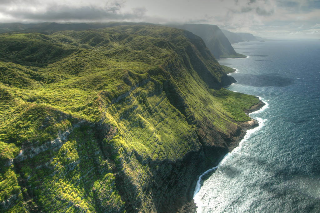
The spectacularly beautiful Kalaupapa Peninsula is the most remote part of Hawaii's most isolated island. The only way to reach this lush green peninsula edged with long, white-sand beaches is on a twisting trail down the steep pali, the world's highest sea cliffs, or by plane. This remoteness is the reason it was, for more than a century, where Hansen's disease (leprosy) patients were forced into isolation.
From the colony's inception until separation ended in 1969, 8000 patients were forced to come to Kalaupapa. Less than a dozen patients (respectively called 'residents') remain. They have chosen to stay in the only home they have ever known and have resisted efforts to move them away. The peninsula has been designated a national historical park and is managed by the Hawaii Department of Health and the National Park Service (![]() %808-567-6802; www.nps.gov/kala).
%808-567-6802; www.nps.gov/kala).
Since visitor numbers are limited each day, you must have a reservation with Damien Tours.
History
In 1835 doctors in Hawaii diagnosed the state's first case of leprosy, one of many diseases introduced by foreigners. Alarmed by the spread of the disease, King Kamehameha V signed a law that banished people with Hansen's disease to Kalaupapa Peninsula, beginning in 1866.
Hawaiians call leprosy i mai hoʻokaʻawale, which means 'separating sickness,' a reference to how the disease tore families apart. Once the afflicted arrived on Kalaupapa Peninsula, there was no way out, not even in a casket. Early conditions were unspeakably horrible and lifespans short.
Father Damien (Joseph de Veuster), a Belgian priest, arrived at Kalaupapa in 1873. A talented carpenter, he built 300 simple houses, nursed the sick and buried the dead. Damien's work inspired others, including Mother Marianne Cope, who stayed 30 years and came to be known as the mother of the hospice movement. Damien died of leprosy in 1889 at the age of 49. In 2009 he became Hawaii's (and America's) first Catholic saint.
2Activities
![]() oKalaupapa TrailHIKING
oKalaupapa TrailHIKING
( MAP GOOGLE MAP )
The Kalaupapa trailhead ( MAP GOOGLE MAP ) is on the east side of Hwy 470, just north of the mule stables, and is marked by the Palaʻau park sign and parked Kalaupapa employee cars. The 3-mile trail has 26 switchbacks, 1400 steps and drops 1664ft in elevation from start to finish.
It's best to begin hiking by 8am, before the mules start to go down, to avoid walking in fresh dung, though you have no choice on the return trip. Allow an hour and a half to descend comfortably. It can be quite an adventure after a lot of rain, though the rocks keep it from getting impossibly muddy. Many find walking sticks a huge help.
TTours
![]() oMolokai Mule RideTOURS
oMolokai Mule RideTOURS
(
MAP
GOOGLE MAP
; ![]() %808-567-6088; www.muleride.com; Hwy 470; tour $210;
%808-567-6088; www.muleride.com; Hwy 470; tour $210; ![]() htours start 7:45am Mon-Sat)
htours start 7:45am Mon-Sat)
Just an incredible journey, a mule ride is the only way down the pali (cliffside) besides hiking, but be prepared – this is not an easy ride. You'll be sore afterwards, even if you're an experienced rider ‒ and it's a safe bet that you've never experienced a ride like this one. Make reservations for the mule ride well in advance.
![]() oDamien ToursBUS
oDamien ToursBUS
(
MAP
GOOGLE MAP
; ![]() %808-221-2153, 808-567-6171; www.damientoursllc.com; tour $60;
%808-221-2153, 808-567-6171; www.damientoursllc.com; tour $60; ![]() hMon-Sat)
hMon-Sat)
Everyone who comes to the Kalaupapa Peninsula is required to visit the settlement with this tour. If you didn't book through Molokaʻi Mule Ride, reservations must be made in advance (call between 4pm and 8pm). Tours last 3½ hours, are done by bus and are accompanied by lots of stories about life in years past. If you're not on the mule ride or other packaged tour, bring your own lunch and a bottle of water. You must be 16 or over.
Pick-ups for the tours are at 10am, whether you arrive on the peninsula on foot, by mule or on a plane.
8Getting There & Away
Makani Kai AirAIRLINE
(![]() %808-834-1111, 877-255-8532; www.makanikaiair.com; round-trip tour package from Moloka‘i/Honolulu $249/315)
%808-834-1111, 877-255-8532; www.makanikaiair.com; round-trip tour package from Moloka‘i/Honolulu $249/315)
Runs regular flights from Hoʻolehua on Moloka‘i and from Honolulu, which are timed to allow for visits in a day. Packages include your place on Damien Tours. A package including walking down, taking the tour and flying back up topside is $149.
DON'T MISS
POST-A-NUT
Why settle for a mundane postcard or, worse, an emailed photo of you looking like a tan-lined fool, when it comes to taunting folks in the cold climes you've left behind? Instead, send a coconut. Gary Lam, the world-class postmaster of the Hoʻolehua post office (
GOOGLE MAP
; ![]() %808-567-6144; Puʻu Peelua Ave;
%808-567-6144; Puʻu Peelua Ave; ![]() h8:30am-4pm Mon-Fri), has baskets of them for free. Choose from the oodles of markers and write the address right on the husk. Add a cartoon or two. Imagine the joy when a loved one waits in a long line for a parcel and is handed a coconut! Depending on the size of your nut, postage costs $12 to $22 and takes three to six days to reach any place in the US; other countries cost more and take longer – and you may run into quarantine issues.
h8:30am-4pm Mon-Fri), has baskets of them for free. Choose from the oodles of markers and write the address right on the husk. Add a cartoon or two. Imagine the joy when a loved one waits in a long line for a parcel and is handed a coconut! Depending on the size of your nut, postage costs $12 to $22 and takes three to six days to reach any place in the US; other countries cost more and take longer – and you may run into quarantine issues.
If Lam, who takes the time to apply a panoply of colored stamps to each coconut, was in charge of the postal service, its current financial woes would likely vanish. Should you want your nut made especially ornate, Teri Waros of Kalele Bookstore (
GOOGLE MAP
; ![]() %808-567-9094; http://molokaispirit.com; 64 Ala Malama Ave;
%808-567-9094; http://molokaispirit.com; 64 Ala Malama Ave; ![]() h10am-5pm Mon-Fri, 9am-2pm Sat;
h10am-5pm Mon-Fri, 9am-2pm Sat; ![]() W) does custom paint jobs.
W) does custom paint jobs.
West End
Apparently uninhabited, Molokaʻi's West End seems just a couple of missed rainfalls from becoming a desert. Much of the land has been controlled by the Molokaʻi Ranch. Its fortunes – for better and more recently for much worse – have affected the entire island.
Given the economic woes of Molokaʻi Ranch, the atmosphere out west is a bit bleak. With the exception of one superlative store, Maunaloa might as well hold tumbleweed races, while the Kaluakoi resort area is beset by financial troubles. Still, you can ignore all the earthly turmoil on one of the many fine beaches.
Kaluakoi Resort Area
rBeaches
![]() oKepuhi BeachBEACH
oKepuhi BeachBEACH
( MAP GOOGLE MAP ; off Kenani Kai)
You can see why they built the defunct Kaluakoi Hotel here: the beach is a rocky, white-sand dream. However, swimming here can be a nightmare. Not only can there be a tough shorebreak, but strong currents are often present, even on calm days.
During winter, the surf breaks close to shore, crashing in sand-filled waves that provide a brutal exfoliation.
A five-minute hike up to the top of Puʻu o Kaiaka ( MAP GOOGLE MAP ; off Kaiaka Rd), a 110ft-high promontory at the southern end of the beach, is rewarded with a nice view of Papohaku Beach. At the top you'll find the remains of a pulley that was once used to carry cattle down to waiting barges for transport to Oʻahu slaughterhouses. There was also a 40ft heiau on the hilltop until 1967, when the US army bulldozed it (and gave the superstitious another reason to ponder the local run of bad luck). There's plenty of parking in the resort's cracked parking lots.
![]() oKawakiu BeachBEACH
oKawakiu BeachBEACH
( MAP GOOGLE MAP )
Kaluakoi's northernmost beach is also the best. Kawakiu Beach is a broad crescent beach of white sand and bright-turquoise waters. It's partially sheltered from the winds that can bedevil the beaches to the south and when seas are calm, usually in summer, Kawakiu is generally safe for swimming.
When the surf is rough, there are still areas where you can at least get wet. On the southern side of the bay, there's a small, sandy-bottomed wading pool in the rocks; the northern side has an area of flat rocks over which water slides to fill up a shallow shoreline pool. Spindly kiawe trees provide shade. Outside of weekends, you may well have the place to yourself.
To get there, turn off Kaluakoi Rd onto the road to the Paniolo Hale (
GOOGLE MAP
; www.paniolohale.org; Lio Pl; studios from $100, 1br/2br from $150/180; ![]() s) condos, but instead of turning left to the condos, continue straight toward the former golf course. Where the paved road ends there's space to pull over and park. You'll come first to a rocky point at the southern end of the bay. Before descending to the beach, scramble around up here for a scenic view of the coast, south to Papohaku Beach and north to ʻIlio Point.
s) condos, but instead of turning left to the condos, continue straight toward the former golf course. Where the paved road ends there's space to pull over and park. You'll come first to a rocky point at the southern end of the bay. Before descending to the beach, scramble around up here for a scenic view of the coast, south to Papohaku Beach and north to ʻIlio Point.
Maunaloa
![]() oBig Wind Kite Factory & Plantation GalleryARTS & CRAFTS
oBig Wind Kite Factory & Plantation GalleryARTS & CRAFTS
(
MAP
GOOGLE MAP
; ![]() %808-552-2364; www.bigwindkites.com; 120 Maunaloa Hwy;
%808-552-2364; www.bigwindkites.com; 120 Maunaloa Hwy; ![]() h10am-4pm Mon-Sat, 1-4pm Sun)
h10am-4pm Mon-Sat, 1-4pm Sun)
Big Wind custom-makes kites for high fliers of all ages. It has hundreds ready to go in stock or you can choose a design and watch production begin. Lessons are available, lest you have a Charlie Brown experience with a kite-eating tree.
There is a range of other goods to browse as well, including an excellent selection of Hawaii-themed books and artworks, clothing and crafts originating from everywhere, from just down the road to far-off Bali.
West End Beaches
![]() oPapohaku BeachBEACH
oPapohaku BeachBEACH
( MAP GOOGLE MAP ; off Kalua Koi Rd)
Straight as a palm tree, the light-hued sands of Papohaku Beach run for an astounding 2.5 miles. The sand is soft and you can often stroll from one end to the other without seeing another soul. Offshore, Third Hole ( MAP GOOGLE MAP ; Papohaku Beach) is one of the island's most challenging surf breaks.
But just when you think you have found the ultimate strand, consider a few leveling details. That intoxicating surf is also a tangle of undertow and unpredictable currents. And there's no easy shade. You can bring an umbrella, but the often strong winds may send it Oʻahu-bound. Those same breezes kick up the fine sand, which can sting on blustery days. So come here for the solitude, but do so with your eyes figuratively, if not literally, wide open.
There are seven turnoffs from Kalua Koi Rd that access the beach and have parking. The first leads to Papohaku Beach Park, a grassy place with picnic facilities under gnarled ironwood and kiawe trees. Bathroom and shower facilities are rugged. You can camp here to the left of the restrooms as you face them from the parking lot, the 'no camping' sign only applies to the area to the right (be sure to read the signs that explain which areas are soaked by the automatic sprinklers on which days). There are seldom any other campers here and the view of the stars at night and the sound of surf is mesmerizing. However, the park can be popular with rowdy folks young and old and occasionally some try to stay the night. Guards are meant to check permits but you may be happier here if you are not alone.
Dixie Maru BeachBEACH
( MAP GOOGLE MAP ; off Pohakuloa Rd)
South of the long stretch of Papohaku Beach, there are small sandy coves surrounded by rocky outcrops. At the southern end of Pohakuloa Rd there's a parking lot with access to a narrow, round inlet, which the ancient Hawaiians knew as Kapukahehu.
It is now called Dixie Maru, after a ship that went down in the area long ago. It's the most protected cove on the west shore, and the most popular swimming and snorkeling area. The waters are generally calmer here than other West End beaches.
Papohaku Beach ParkBEACH
( MAP GOOGLE MAP ; off Kalua Koi Rd)
A grassy place with picnic facilities under gnarled ironwood and kiawe trees. The bathroom and shower facilities are rugged.
Hiking in Lanaʻi & Moloka‘i
In Lana‘i, the Munro Trail swoops past non-native trees, ravines and lookouts, while the Koloiki Ridge Trail ends with a panoramic view of the island. It's waterfalls and history in the Halawa Valley on Moloka‘i.
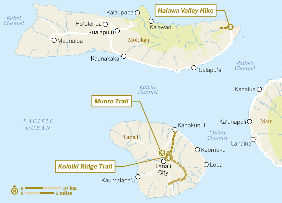
Munro Trail
- Start Lana‘i cemetery
- End Manele Rd
- Length 12 miles; five to seven hours
- Difficulty Moderate
This exhilarating 12-mile adventure through verdant forest can be hiked or mountain-biked but not driven. For the best views, and to avoid getting caught at dusk, start early. Hikers should be prepared for steep grades and allow a whole day. Be aware that rains can turn the dirt path into a red swamp. Watch out for sheer drop-offs, especially when mist, fog and clouds limit visibility.
To start, head north on Hwy 44 from Lanaʻi City. About a mile past the Lodge at Koele, turn right onto the paved road that ends in half a mile at the island's cemetery. The Munro Trail starts left of the cemetery; passing through eucalyptus groves, it climbs the ridge and the path is studded with ohia lehua, ironwood, eucalyptus and Norfolk Island pine trees. The Norfolks, which draw moisture from the afternoon clouds and fog, were planted in the 1920s as a watershed by naturalist George Munro, after whom the trail is named.
The trail overlooks deep ravines cutting across the east flank of the mountain, and passes Lanaʻihale (3370ft), Lanaʻi's highest point. Lookout points dot the trail. On a clear day you can see all the inhabited Hawaii islands except for distant Kauaʻi and Niʻihau along the route. Stay on the main trail, which descends 6 miles to the central plateau. Keep the hills to your left and turn right at the big fork in the road. The trail ends back on Manele Rd (Hwy 440) between Lanaʻi City and Manele Bay.
You can combine a Munro Trail hike with the Koloiki Ridge Trail. Check the latest conditions with locals beforehand.
Koloiki Ridge Trail
- Start/End Lodge at Koele
- Distance 5 miles round-trip; three hours
- Difficulty Moderate
This 5-mile hike leads up to one of the most scenic parts of the Munro Trail. It offers sweeping views of remote valleys (where taro was once grown), Maui and Molokaʻi.
The trail begins at the rear of the Lodge at Koele on the paved path that leads to the golf clubhouse. From there, follow the signposted path uphill past Norfolk Island pines until you reach a hilltop bench with a plaque bearing the poem 'If' by Rudyard Kipling. The heritage center publishes a map that makes following the route easy.
Follow the trail down through a thicket of guava trees to an abandoned dirt service road and you'll intersect with the Munro Trail; after a few minutes you'll pass Kukui Gulch, named for the kukui (candlenut trees) that grow there. Continue along the trail until you reach a thicket of tall sisal plants; about 50yd after that bear right to reach Koloiki Ridge, where you'll be rewarded with panoramic views of much of the island.
Halawa Valley
- Start/End Halawa Valley Beach Park
- Length 4 miles round-trip; three to five hours
- Difficulty Moderate
The hike and spectacle of the 250ft, twin Moaʻula and Hipuapua Falls, which cascade down the back of the lush Halawa Valley, are a highlight of many people's Moloka‘i visit. They are reached via a straightforward 2-mile trail lined with historical sites. To protect these sites, and because the trail crosses private property, visiting the falls requires a hike with a local guide.
There are numerous cultural sites along the path. You'll also pass through lush tropical foliage. Look for the bright orange blossoms of African tulip trees and the brilliant green of beach heliotrope trees. Among the sights are a burial ground that may date to 650 AD and a seven-tiered stone temple.
Expect muddy conditions and wear stout shoes so you can navigate over river boulders. Some river crossings may be especially perilous. Prepare for voracious mosquitoes, bring water and lunch and have plenty of sunscreen. Most people thrill to a bracing plunge into the pools at the bottom of the falls.
Avoid days when small cruise ships visit Moloka‘i as daytripping crowds can lessen the experience. Bring sturdy hiking shoes or sandals, swimsuit, plenty of water, a snack, sunscreen, mosquito repellent and a poncho or protection from the rain.