| Downtown and the West End | Map 1 |
Downtown is a vibrant mix of residential and commercial development, dotted with pocket parks and green spaces. Visitors and locals walk and bike the Seawall and play at the beach.
Apartment buildings, historic houses, and a few modern towers line the leafy streets of the West End, bounded by English Bay, Stanley Park, the Burrard Inlet, and downtown. Most of the city’s hotels are located downtown or in the West End, as are plenty of dining and drinking spots. Robson is a major shopping street, Granville Street is the center of Vancouver’s nightclub district, and the city’s LGBTQ community congregates in the bars and cafés along Davie.
▪ Bill Reid Gallery of Northwest Coast Art (click here)
▪ Nightingale (click here)
▪ Guu Garden (click here)
▪ LIFT Bar & Grill (click here)
▪ Prohibition Lounge (click here)
▪ Reflections Lounge (click here)
▪ English Bay Beach (click here)
▪ Hudson’s Bay (click here)
▪ Fairmont Pacific Rim (click here)
▪ Rosewood Hotel Georgia (click here)
▪ Burrard Hotel (click here)
▪ Listel Hotel (click here)
▪ SkyTrain lines: Canada Line, Expo Line
▪ SkyTrain stops: Waterfront (Canada, Expo Lines); Vancouver City Centre (Canada Line); Burrard, Granville (Expo Line)
▪ Bus lines: 5, 6, 19, 23
TOTAL DISTANCE: 2.5 miles (4 kilometers)
TOTAL WALKING TIME: 1 hour
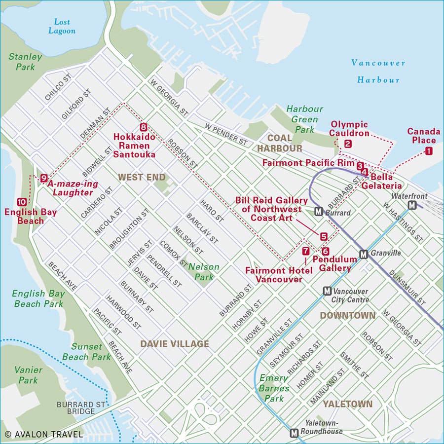
This walking tour takes you from Canada Place on the Burrard Inlet side of downtown, through the city to English Bay, passing numerous landmarks, artworks, and places to eat. You can do this walk anytime, but if you start in the early afternoon, you can wrap up your stroll at west-facing English Bay Beach as the sun is shining over the sea.
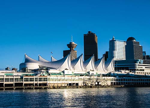
1 Begin your walk at Canada Place, the waterfront landmark with its billowing white sails. Follow the Seawall path one block toward the Vancouver Convention Centre’s west building, and note the building’s living roof. Keeping the water on your right side, continue along the Seawall behind the convention center, passing The Drop, a 20-meter (65-foot) bright blue raindrop sculpture that a Berlin-based art collective created in 2009.
2 At the back of the convention center, after watching the floatplanes taking off and landing on the harbor, turn left up the stairs to Jack Poole Plaza. Look for Digital Orca (2009), by Vancouver artist Douglas Coupland, a sculpture of a whale that appears to be breaching toward the sky. Also on the plaza is the Olympic Cauldron, which was lit when Vancouver hosted the 2010 Winter Olympic Games.
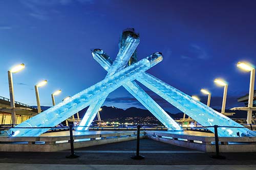
Olympic Cauldron
3 Turn left (east) onto Canada Place, then in one block, turn right (south) onto Burrard Street. Walk one more block to the corner of Burrard and Cordova, and look up. Wrapping around the exterior of the Fairmont Pacific Rim are the words, “Lying on top of a building the clouds looked no nearer than when I was lying on the street.” It’s an art installation by New York artist Liam Gillick.
4 Ready for refreshments? In front of the Fairmont, stop for gelato or sorbetto at Bella Gelateria.
5 When you’ve finished your treats, continue walking south on busy Burrard Street, away from the water. After three blocks, turn left (east) onto Dunsmuir Street and take your first right (south) onto Hornby Street. In the middle of the block is the Bill Reid Gallery of Northwest Coast Art, one of the best places downtown to explore aboriginal art. Allow about an hour to walk through the gallery.
6 Exit the gallery and turn right (south) on Hornby. In one block, at the corner of Hornby and Georgia Streets, cross the street and go into the HSBC Building (885 W. Georgia St.). Why stop at a bank office? In the lobby is a massive, swinging stainless steel pendulum, an art piece called Broken Column (1987) by Alan Storey. The building’s air circulation system powers its movement. Also in the lobby, the free Pendulum Gallery mounts small changing art exhibitions.
7 Diagonally across Hornby and Georgia Streets is the landmark Fairmont Hotel Vancouver, built in 1939. Duck into the lobby for a quick look, and then exit the building, turning left (south) onto Burrard Street.

Fairmont Hotel Vancouver
8 In one block, cross Burrard and turn right (west) onto Robson Street. Robson is one of downtown’s main shopping streets, and while many of the stores are international chains, it’s still a lively district. This retail route gradually gives way to restaurants, primarily noodle shops, Korean eateries, and other Asian spots. If you’d like to pause for lunch, line up for a bowl of tokusen toroniku ramen at Hokkaido Ramen Santouka, on Robson six blocks from Burrard.
9 After your meal, continue on Robson for one more block, and turn left (south) onto Denman Street. You’re now in the heart of the West End, with more small food spots and neighborhood shops along Denman. Stay on Denman for six blocks to Morton Park, where you’ll spot 14 grinning bronze figures. That’s A-maze-ing Laughter, the popular public art piece by Chinese artist Yue Minjun.
10 Cross Beach Avenue to English Bay Beach, where you can sit in the sand and do some people-watching, resting up from your downtown explorations.
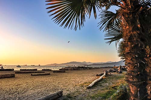
English Bay Beach
| Gastown and Chinatown | Map 2 |
Gastown, which centers on Water and Cordova Streets between Richards and Main Streets, is one of the city’s oldest neighborhoods, with brick and stone buildings dating to the early 1900s. Beyond its historic facades, Gastown is known for its stylish boutiques and aboriginal art galleries.
The ornate Millennium Gate on Pender Street marks the entrance to Vancouver’s fast-changing Chinatown. Though a few traditional herbalists, tea shops, and produce markets remain, more and more hip eateries are moving in. Many of Vancouver’s most innovative restaurants have opened here.
▪ Dr. Sun Yat-Sen Classical Chinese Garden (click here)
▪ Chambar (click here)
▪ L’Abbatoir (click here)
▪ The Pourhouse (click here)
▪ Coastal Peoples Fine Arts Gallery (click here)
▪ Hill’s Native Art (click here)
▪ Lululemon Lab (click here)
▪ John Fluevog (click here)
▪ Skwachàys Lodge (click here)
▪ SkyTrain lines: Expo Line
▪ SkyTrain stops: Waterfront, Stadium-Chinatown
▪ Bus lines: 4, 7, 14, 16, 20, 22, 23
TOTAL DISTANCE: 1.8 miles (3 kilometers)
TOTAL WALKING TIME: 45 minutes
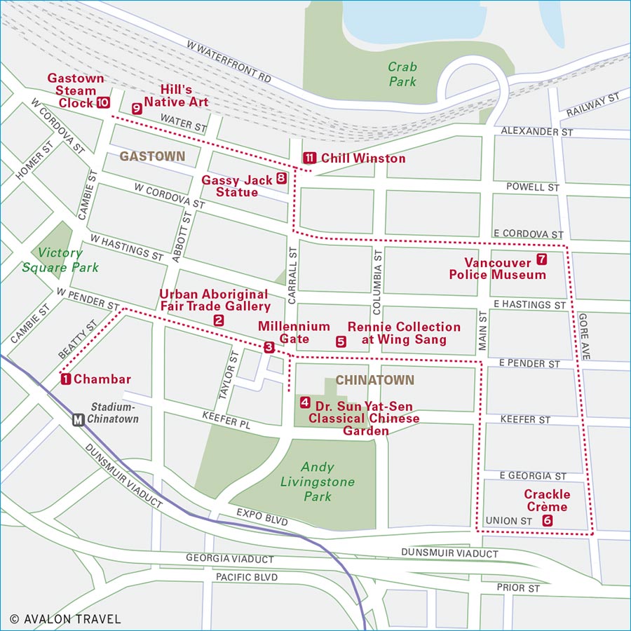
This walk takes you through two of Vancouver’s oldest neighborhoods. Begin with lunch, stop to explore aboriginal art galleries, the city’s serene Chinese garden, and the unusual Police Museum, and then wrap up your afternoon with cocktails in Gastown.
1 Fuel up for your walk with lunch at Chambar, adjacent to the Stadium-Chinatown SkyTrain station. In a heritage brick building on Beatty Street, this restaurant creatively mixes flavors of Belgium and North Africa with local ingredients.
2 After lunch, turn right out of the restaurant, following Beatty Street one block to Pender Street. Turn right onto Pender, and go east two blocks. On the left side of Pender, stop at the Urban Aboriginal Fair Trade Gallery, inside Skwachàys Lodge, Canada’s first aboriginal arts hotel, for a look at their works by native artists. As you leave, notice the large aboriginal sculpture atop the hotel building.
3 Turn left out of the gallery, cross under the ornate Millennium Gate, which marks the entrance to Chinatown, and walk one more block east on Pender.
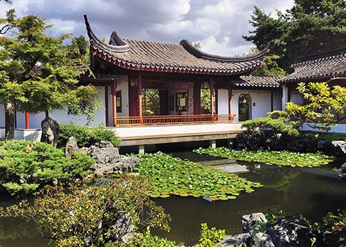
4 At Carrall Street, turn right, walk half a block, and turn left at the garden wall to find the entrance to the Dr. Sun Yat-Sen Classical Chinese Garden. It’s worth stopping to tour this peaceful retreat, the first authentic Ming Dynasty garden created outside of China.
5 From the garden, retrace your steps back north toward Pender Street and turn east (right) to find the Rennie Collection at Wing Sang, a private art museum. The brick building that houses the museum, constructed in 1889, is the oldest structure remaining in Chinatown.
6 Continue one block east on Pender to Main Street and turn right. As you walk south on Main, notice Chinatown’s mix of new condos and old-time shops. Stay on Main three blocks, then turn left onto Union Street. Midway down the block is Crackle Crème, a café that specializes in crème brûlée.
7 After your break, turn left out of the café, and in half a block, turn north (left) onto Gore Avenue. Follow Gore five blocks north. At Cordova Street, turn left to find the entrance to the Vancouver Police Museum on your left. The exhibits at this museum, in the former city morgue, detail Vancouver’s seamier side.
8 When you leave the museum, turn left onto Cordova, take the first right onto Main, and in one block, turn left onto Powell Street, which will take you toward Gastown. Follow Powell Street two blocks west to Maple Leaf Square, where Water, Alexander, Powell, and Carrall Streets meet. Stop for a photo at the statue of Gassy Jack, the British sailor for whom Gastown is named.
9 Continue west on Water Street, the main street in Gastown, where several galleries specialize in works by aboriginal artists. A block and a half west of Maple Leaf Square is Hill’s Native Art, which has one of the city’s largest collections of First Nations arts and crafts.
10 Take a right out of Hill’s, and just across Cambie Street (at the corner of Water), you’ll see the Gastown Steam Clock, which toots its whistle every quarter hour.
11 Ready for a drink? Retrace your steps two blocks east on Water Street to Maple Leaf Square, where you can wrap up your walk with a cocktail on the patio at Chill Winston.
| Yaletown and False Creek | Map 3 |
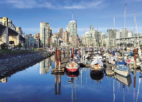
Yaletown’s renovated brick warehouses, once part of an industrial district, today house a chic mix of restaurants, boutiques, and drinking spots. Browse the fashionable shops, meet for cocktails on streetside patios, and dine on local seafood in the upscale restaurants. The city’s sports arenas, including the home ice of the Vancouver Canucks, are also nearby.
False Creek is home to Science World, the family-friendly science museum in a geodesic dome. Also here is the Olympic Village, where athletes stayed during the 2010 Winter Games, now a complex of pubs, cafés, and condos. South of False Creek is an emerging district of craft breweries and beer-centric pubs, perfect for a day of strolling and sipping.
▪ Science World (click here)
▪ Ancora Waterfront Dining and Patio (click here)
▪ 33 Acres Brewing (click here)
▪ Tap & Barrel (click here)
▪ Opus Bar (click here)
▪ Vancouver Canucks (click here)
▪ Fine Finds Boutique (click here)
▪ Opus Hotel Vancouver (click here)
▪ SkyTrain lines: Canada Line, Expo Line
▪ SkyTrain stops: Yaletown-Roundhouse, Olympic Village (Canada); Stadium-Chinatown, Main Street-Science World (Expo)
▪ Bus lines: 3, 6, 19, 23, 50, 84
▪ Ferries: Aquabus, False Creek
TOTAL DISTANCE: 2.6 miles (4.25 kilometers)
TOTAL WALKING TIME: 1.5 hours

On this excursion, which includes a combination of walking and ferry-hopping, you’ll start and end in Yaletown. In between, you’ll explore the Olympic Village, the emerging arts district known as “The Flats,” and the False Creek waterfront. Stop along the way to sample some craft beer.
1 Start your stroll with coffee and pastries at Yaletown’s Small Victory Bakery. When you’re ready to wander, exit the bakery, turning left on Homer Street, and take an immediate left onto Helmcken Street. Follow Helmcken two blocks down the hill, and turn right onto Mainland Street, checking out the neighborhood’s restored warehouse buildings. In one block, at Davie Street, turn left to walk south toward the waterfront.
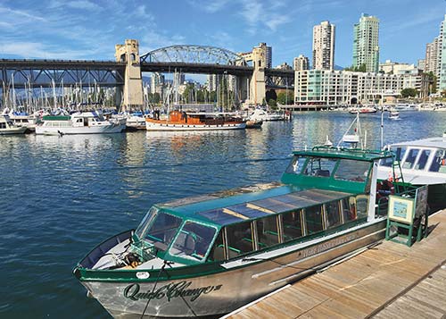
2 In two blocks, at the corner of Davie and Pacific Boulevard, stop for a quick look at the Engine 374 Pavilion to see the locomotive that pulled the first transcontinental passenger train into Vancouver in 1887. Continue south on Davie Street one more block to False Creek and the Aquabus ferry dock, where colorful ferries shuttle across False Creek, which British naval officer and explorer George Henry Richards is credited with naming. In 1859, Richards traveled up what he thought was a creek in search of coal deposits but discovered that this “False Creek” was actually an inlet of the Pacific Ocean. Board the ferry headed east to The Village.
3 When you get off the ferry, explore the cluster of contemporary buildings in front of you: the Olympic Village, also known as the Village at False Creek. The neighborhood’s buildings, which housed athletes during the 2010 Olympic Games, have been converted into condominiums, and the district has several brewpubs, cafés, public art pieces, and a community center.
4 If you’re ready for a break, nab a patio seat at Tap & Barrel, where they’ve got a long list of B.C. beer and wines on tap and great views of the city skyline.
5 From the Olympic Village, you’ll detour away from the water to explore an emerging arts district called The Flats. Walk south through the plaza on Salt Street, past the massive sculptures The Birds, and continue two blocks to West 1st Avenue. Turn left onto 1st, and go three blocks east, crossing Main Street. Look for the Winsor Gallery on your right; stop and see what’s on view in this contemporary art gallery.
6 Leaving the gallery, turn right to continue east on 1st Avenue. In two blocks, when 1st comes to a T at Thornton Street, turn left to check out two more art spaces, Equinox Gallery and Monte Clark Gallery, both in the same brightly painted building among the warehouses at the foot of Thornton.
7 Retrace your steps up Thornton Street, turning right onto 1st Avenue, then taking the next left onto Scotia Street. Cross busy 2nd Avenue, then continue south up the hill on Scotia for three blocks, turning right onto 5th Avenue. Follow 5th one block west to Main Street, turn left onto Main, and you’ll find your next stop, Brassneck Brewery, where you can do a tasting of their small-batch beer.
8 Turn left out of the brewery onto Main and walk two blocks south. At 8th Avenue, turn right, walk two more blocks, and you’ll see 33 Acres Brewing on your right. Stop for another beer tasting and a snack, too. To get back to the ferry, turn right onto 8th Avenue and take the first right onto Manitoba Street. Follow Manitoba 10 blocks north, back to the Olympic Village. Pause to take photos of the city skyline and Science World’s dome before boarding the Aquabus to return to the Yaletown docks.
| Granville Island | Map 4 |
This former industrial district, across False Creek from downtown, is one of Vancouver’s most popular attractions. Technically a peninsula, the 38-acre island is home to more than 300 businesses, including art galleries and theaters, as well as the popular Granville Island Public Market. A few industrial elements remain, including Ocean Concrete, whose brightly painted cement trucks chug around the island.
The island and the Public Market get packed with visitors in the afternoons and on weekends, especially on sunny summer days. Take a ferry from downtown, cycle, or walk onto the island, rather than driving, if you can.
▪ Granville Island Public Market (click here)
▪ Railspur Alley (click here)
▪ Eagle Spirit Gallery (click here)
▪ Federation of Canadian Artists Gallery (click here)
▪ Vancouver Theatre Sports League (click here)
▪ The Umbrella Shop (click here)
▪ Bus lines: 50
▪ Ferries: Aquabus, False Creek Ferries
| Kitsilano and UBC | Map 5 |
Kitsilano has a great beach, several museums in waterfront Vanier Park, and lots of shops and restaurants, particularly along West 4th Avenue, between Burrard and Balsam Streets.
On the city’s far west side, surrounded by forests and sea, the University of British Columbia (UBC) is worth visiting for its stellar Museum of Anthropology, and for several gardens and smaller museums. Also on campus are a modern concert hall and the only working farm within the city of Vancouver.
Point Grey, between the university and Kitsilano, is a leafy residential area with family-friendly sandy beaches along its northern shore. Pacific Spirit Regional Park, Vancouver’s largest park, is also located here.
▪ Museum of Vancouver (click here)
▪ Museum of Anthropology (click here)
▪ Nitobe Japanese Garden (click here)
▪ Maenam (click here)
▪ Chocolate Arts (click here)
▪ Chan Centre for the Performing Arts (click here)
▪ Kitsilano Beach (click here)
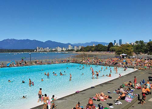
▪ Kitsilano Pool (click here)
▪ Jericho Beach (click here)
▪ Pacific Spirit Regional Park (click here)
▪ Kidsbooks (click here)
▪ Les Amis du Fromage (click here)
▪ Wanderlust (click here)
▪ Bus lines: 2, 4, 7 (Kitsilano); 4, 14, 84, 99 (UBC and Point Grey)
▪ Ferries: Aquabus, False Creek Ferries
| Cambie Corridor | Map 6 |
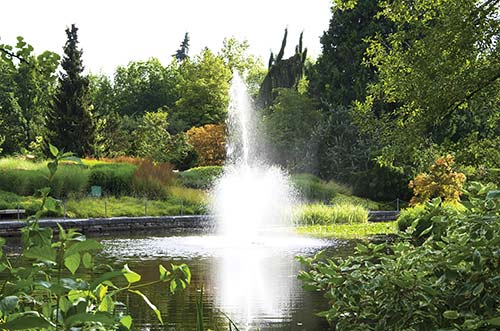
Cambie Street runs between downtown Vancouver and the Fraser River, bisecting the city’s east and west sides. The notable VanDusen Botanical Garden is located off Cambie, and to the west, the South Granville district boasts high-end art galleries.
To the east, browse funky Main Street for its vintage clothing shops, independent fashion boutiques, and locavore restaurants. You can always discover something new in this fast-changing neighborhood.
▪ VanDusen Botanical Garden (click here)
▪ West (click here)
▪ The Acorn (click here)
▪ Bau-Xi Gallery (click here)
▪ Douglas Reynolds Gallery (click here)
▪ Barefoot Contessa (click here)
▪ Front and Company (click here)
▪ SkyTrain lines: Canada Line
▪ SkyTrain stops: Broadway-City Hall, King Edward
▪ Bus lines: 3, 9, 10, 15, 17, 99
| Commercial Drive | Map 7 |
Funky Commercial Drive runs north-south through the city’s East Side. Once the heart of Vancouver’s Italian community, the neighborhood is now home to a diverse collection of residents. Along The Drive, you’ll find pubs, cafés, and a multicultural mix of casual places to eat.
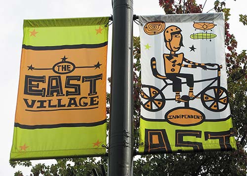
The up-and-coming East Village district is along East Hastings Street, between Victoria Drive and Renfrew Street. Nearby, Powell Street is the center of Vancouver’s booming craft brewery scene.
▪ Parallel 49 Brewing Company (click here)
▪ Odd Society Spirits (click here)
▪ The Pie Shoppe (click here)
▪ Storm Crow Tavern (click here)
▪ Vancouver East Cultural Centre (click here)
▪ SkyTrain lines: Expo Line, Millennium Line
▪ SkyTrain stops: Commercial-Broadway (Expo, Millennium); VCC-Clark (Millennium)
▪ Bus lines: 4, 7, 14, 16, 20, 135
| Richmond | Map 8 |
Vancouver is now considered the most Asian metropolis outside Asia. Many of its Asian residents have settled in Richmond, a city of more than 200,000 on Vancouver’s southern boundaries, where more than half the population is of Asian descent, with most from China, Taiwan, or Hong Kong.
Richmond has several multicultural attractions to explore, including two popular night markets and some of the best Chinese restaurants in North America. The city’s waterfront Steveston Village was important in the region’s fishing history and still houses a bustling fish market and numerous seafood restaurants. It’s also a departure point for whale-watching cruises.
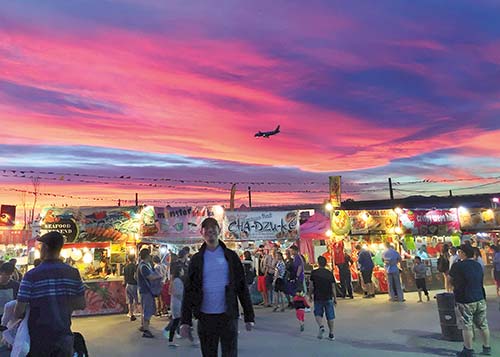
▪ Richmond Night Market (click here)
▪ Bamboo Grove (click here)
▪ New Spicy Chili Restaurant (click here)
▪ Hao’s Lamb Restaurant (click here)
▪ Golden Paramount Seafood Restaurant (click here)
▪ SkyTrain lines: Canada Line (Richmond-Brighouse branch)
▪ SkyTrain stops: Aberdeen, Lansdowne, Richmond-Brighouse
| The North Shore | Map 9 |
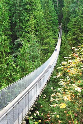
Ready to get outdoors? Across the Burrard Inlet, the North Shore mountains provide the backdrop for the waterfront cities of North Vancouver and West Vancouver. In any season, you can find plenty of adventures here, whether you’re swinging across the Capilano Suspension Bridge, exploring the rainforest in Lighthouse Park, or kayaking in Deep Cove. Visit Grouse Mountain to learn about local wildlife, climb “Mother Nature’s Stairmaster,” or head down the ski trails. Several other peaks offer hiking, snowshoeing, and skiing—all a short trip from the city center.
▪ Grouse Mountain (click here)
▪ Capilano Suspension Bridge (click here)
▪ Deep Cove Kayaks (click here)
▪ The Grouse Grind (click here)
▪ Lighthouse Park (click here)
▪ Ferries: SeaBus
▪ Bus lines: 228, 229, 230, 236, 241, 246, 250, 257