
Wildfire, Climate & People: Perspectives and Warnings from the Past Thomas W. Swetnam, PhD
Dr. Tom Swetnam is a professor of dendrochronology and director of the Laboratory of Tree-Ring Research at the University of Arizona. He studies changes in climate and forest disturbances using tree rings and other data. His work centers on understanding forest and wildfire dynamics in pine-dominant and giant sequoia forests of the western United States. He has also worked in Mexico and South America and is currently studying fire, climate and carbon dynamics in central Siberia. He has authored and co-authored more than 120 papers and serves as the director of the world’s largest laboratory dedicated to all aspects of tree-ring research and education.
I’m going start with a long-term perspective of natural and cultural history in our landscapes here in the western U.S. and particularly in the southwest. I am referring in part, to the rather ominous word, “warnings” in the title of my talk.
Figure 1 is a photograph of the magnificent cliff dwelling called Keet Seel, at Navajo National Monument in Arizona. There are other truly spectacular ancient ruins around the Southwest, such as Pueblo Bonito at Chaco Canyon in New Mexico and Cliff Palace at Mesa Verde, Colorado. Anyone who has been to these sites is struck by the mystery. You see the ancient, monumental architecture, the imposing, great cliffs and wonder: why did people build in these rather ominous, but beautiful places? Who were they? And, especially, why did they leave? It has been a mystery since European-Americans first saw these ruins. It was only during the beginning of the 20th century that scientists began to solve the mysteries, to discover the timing of when people lived here and the reasons they left. These discoveries came about in part because of the work of an astronomer by the name of Andrew Ellicott Douglass, who was the first dendrochronologist (that is, tree-ring scientist).
Douglass came to the Southwest to build the first astronomical observatory in Flagstaff, Arizona in 1894. His interest was solar variability, sunspot cycles, and how the sun might affect the Earth’s climate. At that time there were very few long-term rain gauge records that he could use to compare with the 400-year sunspot record that astronomers had been keeping since Galileo. But he realized that he could use tree rings in pine trees from the Southwest as a proxy for rain gauge records, because he found that in this arid region, wide rings were correlated with wet years and thin rings grew during drought years.
In developing the science of dendrochronology, Douglass devised a method of dating wooden materials. With this method, which is called “cross-dating,” he was able to match ring-width patterns between living and dead trees during the period that they overlapped in time, and in this way bridge back in time and determine the calendar dates of the outermost rings of the roof beams from the great ruins. From this work, he discovered that people built these magnificent structures from about the ninth century onward, and then mostly abandoned them in the 12th and 13th centuries, with different timing in different places. (These people were the ancestors of some of the Native Americans who live today in New Mexico and Arizona.)

Figure 1: Keet Seel, Navajo National Monument, Arizona. Many roof beams from this village have outermost tree rings in 1272 AD. This village and most of the other human settlements on the Colorado Plateau were abandoned sometime during or soon after a deep drought that occurred from about 1276 to 1297 (photo courtesy of Jeff Dean, Stahle and Dean 2011).
When cross-dating the roof beams, Douglass noticed that the outermost rings on many of them were very narrow. He inferred that this was likely a drought period and probably had something to do with the abandonment of these sites. This became known as the Great Drought of the late 1200s AD. That interpretation has more or less held up over the decades, but it is not quite so simple a story that only drought was responsible for people leaving these places.
As with most things in human and ecological history, more than one thing usually causes change. It is notable, for example, that people living there had survived previous droughts as bad as the late 1200s drought, but they did not leave during the earlier dry spells. This is in accord with a general theme of Collapse, Jared Diamond’s book about societal disruptions around the world. It is usually not just one thing, but multiple contributing factors and contingent events. For example, various social stresses can occur that increase vulnerability of societies to climate shocks, such as warfare or arrival of a large number of strangers who compete for resources. Other key factors may be overuse of a vital, local resource, or overdependence upon an imported resource that suddenly becomes unavailable, or agricultural problems and so on. Does that sound familiar?
But still, climate has been centrally important in some past collapses. Again, it seems that social systems and ecological systems can become more vulnerable over time to climate change because of things that people do — or do not do. There are a number of new papers on the topic of climate variability and its likely impacts on societies, but I’ll draw attention to two examples that involve tree rings: the fall of the Roman Empire and the collapse of the Ming Dynasty, both of which correlated with drought or cold periods. (See Cook et al. 2010 and Büntgen et al. 2011 in the references.) Again, climate is not discussed as a single causal factor, but as a likely contributing factor.
Closer to home and time, we can look at the Dust Bowl as an example of increased vulnerability caused by humans, followed by an extreme climatic event. This case is indeed close to home for me. My parents, Fred and Grace, grew up in Trinidad, Colorado, right on the edge of the Dust Bowl during 1930s. They told me stories from their childhoods about these great clouds of dust coming in. This story is presented well in Tim Egan’s book, The Worst, Hard Time. Millions of acres of prairie sod were ploughed over for farmland. This was well intentioned. They were converting ancient grasslands to farmlands, and it was boom time. People were told, “The rain will follow the plough.” There were good times in the 1910s and 20s, but they turned over the sod that had held the soil in place for thousands of years through many previous droughts of worse magnitude than that of the 1930s. Then the soil was exposed to the elements, drought came, markets changed, crops failed, and the winds blew away the soil and many of the people.
Increased vulnerability combined with climate extremes and change, is, in part, the situation with our forests today. The causes of increased vulnerability include over grazing, logging without adequate follow-up forestry practices, fire suppression, and introduction of non-native species that are often highly flammable. And now, climate is changing too.
Even, however, if we did not have greenhouse gases driving a large part of the recent warming, we would still be in trouble here in the West. Here is how we know this from our tree-ring studies: Since A.E. Douglass’ time, we have greatly expanded our tree-ring collections all around the world. We have thousands of sites now, and each site is a forest or woodland where we have sampled 10 to 30 trees or more, and measured all of the tree rings. In the western U.S., these are mostly “drought sensitive” tree-ring sites where the tree-ring growth is primarily controlled by seasonal, annual, and decadal variation in rain fall amounts. The extensive data networks and calibrations of these ring-width records with rain gauge records and drought indices from the 20th Century have enabled us to reconstruct very detailed maps of past drought extent and magnitude. From these maps we can see the great droughts of the 1100s and late 1200s when the massive pueblos and cliff dwellings were abandoned, and we can assess the long-term context of more recent droughts.
An example of how accurate these records can be, especially for drought and river flow reconstructions, is this time series of the Colorado River illustrated by Figure 2. The green is the record from tree rings from hundreds of trees and dozens of sites on the west slope of the Colorado Rockies and in the headwaters of the Colorado River. The blue is the river gauge record from Lee’s Ferry. Dendroclimatologists calibrated 20th century tree ring records with the gauged river record from the same time period. More than 80% of the variance in the gauged record is estimated by the tree-ring record. From these tree-ring estimates, then, we can derive this long perspective of the past 1,200 years of Colorado River flows.
Unfortunately, this is really bad news for the West. Former Colorado Governor Richard Lamm said that one of his “worst days in office” was when he went to Boulder to talk to tree-ring scientists. They told him about the 30-year droughts of the 12th and 13th centuries that were of greater magnitude than anything that we’ve witnessed during this time of building up our populations with all of our dependence upon surface water in the West. This is a worrisome story —and a warning —that is largely unheeded by most people living in the western U.S.
This is why we are in trouble, even without the greenhouse-warming problem, which is also quite real. Consider the difficulties we will have if human-induced climate change exacerbates drought magnitudes and duration in the Southwest even beyond what had occurred naturally before we started pumping large amounts of greenhouse gases into the atmosphere. Unfortunately, most computer models of future climate changes in the Southwest as a consequence of increasing greenhouse gas concentrations in the atmosphere point to increasing drought conditions.

Figure 2: A tree-ring reconstruction of 1,200 years of Colorado River flows. The droughts of the 1100s and 1200s exceeded in length and depth the 1950s drought, which was one of the worst droughts experienced during the past 100 years (figure modified from Meko et al. 2007).

Figure 3: Ancient giant sequoia trees survived dozens of surface fires during their lives. The Grizzly Giant in Mariposa Grove at Yosemite National Park is at left. A cross section of a giant sequoia in the Giant Forest at Sequoia National Park contains annual rings back to 259 BC, and it has more than 130 fires recorded by fire scars and other tree-ring evidence (photos courtesy of Tony Caprio, Swetnam 1993, Swetnam et al. 2009).
Getting back to the topic of forests, I will now focus primarily on wildfires, because others here today are discussing beetle outbreaks. Drought and fire are obviously correlated; but we’ve been learning a lot more about important aspects fire, climate and forest ecosystems in the last 20 or 30 years. In particular, from tree rings, we can obtain a long historical picture of the interactions of climate, people and fire in forest ecosystems. I’ve been very fortunate to have studied giant sequoia over the last 20 years when we have been unraveling these connections.
Sequoias are truly magnificent trees (see Figure 3). Some trees are more than 3,200 years old. They live in a habitat we call a “frequent fire regime” type, or a “surface fire” type. That is, before forest managers begin to put fires out, surface fires burned here about once or twice per decade. We can get a very detailed record of fires by studying tree rings in these trees. For example, you can in Figure 3 see scars as blackened lines within the rings (lower right).
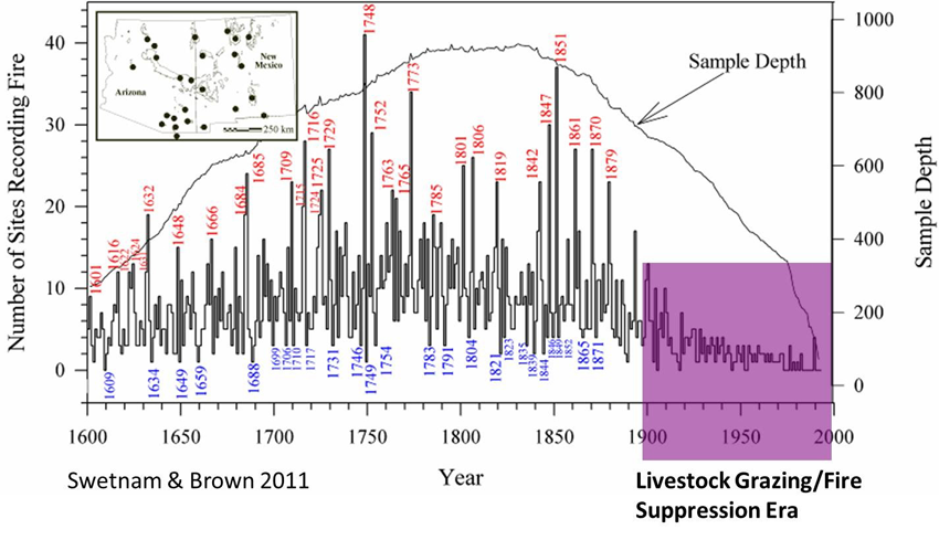
Figure 4: The history of fires in Arizona and New Mexico from 1600 to 2000 AD as reconstructed from tree-ring analyses of fire scarred trees in 63 sites. The red labeled years are extensive fire years when fires occurred simultaneously in many different mountain ranges, and they are highly correlated with drought years. The blue labeled years are synchronous low fire occurrence years during relatively wet years. The period from circa 1900 to 2000 shows relatively few sites recording fire scars because the frequent, low severity surface fires were mostly eliminated by livestock grazing and active fire suppression efforts by government agencies (figure modified from Swetnam and Brown 2011).
This particular cross section is located in the parking lot in front of the General Sherman Tree, the world’s largest tree, at Sequoia National Park in California. This cross section goes back to about 259 BC, and it has more than 130 different fire dates recorded on it as fire scars and growth changes. Sequoias are well-adapted to fire. I’m skimming over a lot of work on this, but we see that drought and hot periods are very well correlated with the large fire years and highest fire frequencies.
One of the most striking things we find in tree-ring and fire scar studies across the western U.S. is the lack of widespread fire through most of the 20th century. The longest intervals between fires occurred after we began to put surface fires out. Figure 4 is another example from the Southwest: a time series of numbers of sites showing fire scars over the whole region. The history is one of many big fire years and some small fire years.
The 20th century is very different, though, with its greatly reduced fire frequency. This was originally due to heavy livestock grazing by pioneers who brought in huge sheep and cattle herds, which grazed the fine grassy fuels. These grasses carried the frequent surface fires, but after heavy grazing began, the widespread fires tended to cease. Then Smokey Bear (that is, government agencies) began putting fires out very effectively, especially after World War II with the use of surplus aircraft. So, over most of the past century, we have effectively eliminated surface fires from many of these pine forests. Now uncontrollable fires are returning during the hot and dry years, and they are burning with very high severity and through the forest canopies over increasingly large areas.
This historical pattern was typical of the lower elevation, dryer kind of pine-dominant forest, such as ponderosa pine, but also of many of our mixed-conifer types. A lot of this kind of landscape exists in Colorado and elsewhere in western U.S. The consequence of disrupting these frequent fire regimes is changed landscapes, particularly increased woody fuels on forest floors. Figure 5 is an aerial photograph of the Santa Fe Watershed as late as 1935 on the left, and more recently on the right. The scale of these photos is a couple of miles across. The light colored areas in the 1935 image were grasslands or savannas. Then you see on the right, in the modern period, increased forest densities. This is a municipal watershed, so its health and stability is important to the city of Santa Fe. Loss of the forest cover here by extreme wildfires could result in filling municipal reservoirs with sediment, or even breaching the reservoirs, causing devastating flooding.
Now, I want to caution that these kinds of fire regimes Forest and the at Risk causes of forest changes are not uniform across the West. This situation I have described is most common in forest types that formerly sustained frequent surface fires. High elevations, where you find spruce, fir, and lodgepole pine, for example, did not have frequent surface fires in the past. So for the most part, this is a change that is particular to the ponderosa pine-dominant and dryer mixed-conifer forest types. Nevertheless, this is a very extensive and serious problem across the West.
The 2002 Rodeo-Chediski Fire burned almost a half million acres and more than 400 homes in Arizona. (The Wallow Fire of 2011 in Arizona also burned more than half a million acres). Fuels and forest changes are a key problem in many of our landscapes, but the changes we are witnessing in recent years are most likely also related to warming temperatures and extreme droughts. Dr. Tony Westerling and a group of other scientists, including me, published a study in the journal Science in 2006, where we showed a striking correlation between rising temperatures across the Western United States and increasing numbers of large fires. This was especially true in the years when spring arrived earliest. There are particular years when the snowmelt occurs earlier and we have seen many more fires. Climate change – warming – is most likely involved along with other factors. F or example, invasive species are a real issue in our lower elevations and deserts. African Buffel grass is now allowing fire to spread in the Sonoran desert for the first time, and people are also building homes in these landscapes.
It was interesting to see an editorial in the New York Times (October 31, 2010) about the Colorado River and Secretary Salazar’s initiatives on studying the Colorado River and water problems. The editorial even mentioned tree rings and the extreme droughts of the past they warn us about. One thing in particular that struck me when I saw this editorial was an advertisement alongside the column for the movie The Black Swan. This reminded me of Nassim Nicholas Taleb’s book. The essence of the Black Swan concept is that (1) high-impact, hard-to-predict, rare events have a dominant role in history and (2) people have a very hard time conceiving or accepting that such extreme events can or will occur. People thought there were only white swans in nature, until black ones were discovered in Australia. The point is that rare events – extreme events – are a characteristic of complex and highly interconnected systems, and therefore of economic, ecological and climate history. A first step in coping with Black Swans is recognizing their existence, and the next is to build for robustness and resilience in systems so that they may withstand or recover from the large impacts of extreme events when they occur.
To conclude, I think that to prepare for more Black Swans in coupled human-natural systems, including forests, we need to employ the philosophies of both John Muir and Gifford Pinchot. That is, our goals should include preservation, protection and restoration. Naturalness is still important, but we also need to consider utilization of resources and intensive management as a means of achieving ecological resilience. The fact is: we humans are now the stewards of the Earth’s atmosphere and forests.

Aerial photos from the Santa Fe watershed, showing a view of forest and savanna in 1935, and the same view 70 years later with in-growth of conifers as a consequence of fire suppression (figure modified from Margolis and Balmat 2009).