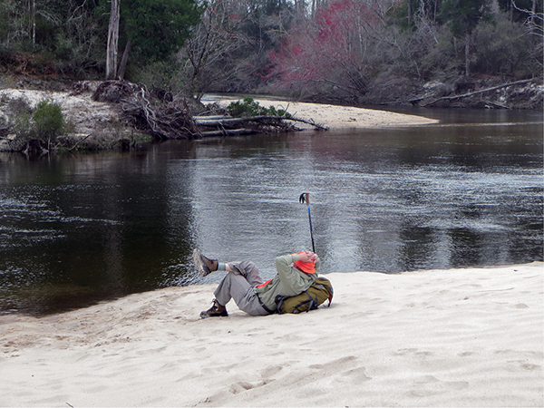
Relaxing on the banks of the Perdido River
7 Perdido River Trail
A beautiful little wilderness hike in the midst of one of the fastest-growing counties in Alabama. Along the Perdido River Trail you get a good mix of the natural beauty of the Gulf Coast, including Atlantic white cedar bogs, a beautiful black-water river (that’s also great for swimming), and white sandbars. You’ll also have excellent wildlife-spotting opportunities. Keep your eyes peeled for bald eagles, ospreys, and maybe an alligator.
Start: Parking area / trailhead alongside the river
Distance: 2.8 miles out and back
Hiking time: About 1.5 hours
Difficulty: Easy over level terrain
Trail surface: Dirt forest roads, sand and dirt footpaths
Best seasons: Year-round
Other trail users: None
Canine compatibility: Dogs permitted
Land status: State wildlife management area
Nearest town: Robertsdale
Fees and permits: None
Schedule: Year-round
Maps: USGS Barrineau Park, FL; DeLorme: Alabama Atlas & Gazetteer, page 63 D10
Trail contact: Alabama Hiking Trail Society, PO Box 231164, Montgomery, AL 36123; www.hikealabama.org
Special considerations: This trail is located in a state wildlife management area. In the fall and winter, check hunting seasons and times before heading out at www.outdooralabama.com/hunting and wear hunter orange during these times.
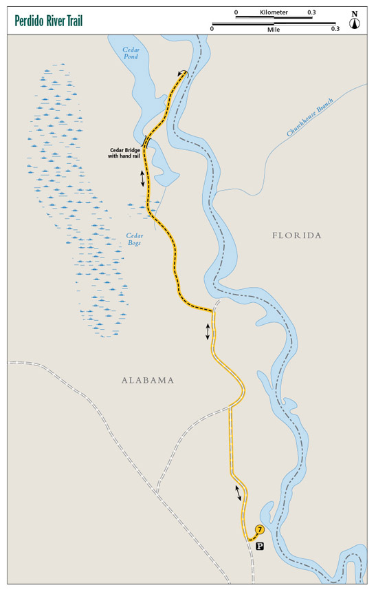
Finding the trailhead: From Robertsdale at I-65 exit 53 (Wilcox Road), head north on CR 64 for 7.1 miles. Turn right onto AL 112 (Old Pensacola Road). Travel 9.4 miles and turn left at Duck Place Road (Barrineau Park Road). Immediately after you turn onto the paved Duck Place Road, turn right onto the dirt River Road. Follow River Road for approximately 1.7 miles, then turn left onto Nims Fork Road. Travel 0.3 mile and turn right onto an unnamed road. Travel approximately 0.5 mile around a curve to the left, then turn right onto another unnamed road. Follow this road approximately 0.4 mile and cross railroad tracks, then take a right at the fork. Travel approximately 0.7 mile and turn left onto yet another unnamed road. Travel 1 mile. The road makes a sharp curve to the right. After the curve, continue another 1.7 miles to a triangle clearing where you can park. The trail begins on the north side of this parking area. GPS: N30 39.477' / W87 24.244'
The Hike
A few years ago no one would have ever dreamed that you could take a walk in a wilderness environment in one of the fastest-growing counties in Alabama, Baldwin, along the Gulf Coast, but today you can on the Perdido River Trail.
The trail is located on the banks of its namesake river that borders Florida and Alabama. The hike described here is a 2.8-mile out-and-back over a nice mix of dirt and sand footpaths and old logging roads that take you through amazing Atlantic white cedar bogs and past beautiful white sandbars. All in all it makes a wonderful outing for families and individuals looking for a day hike in the woods with plenty to do and see along the way, and it’s only a stone’s throw from the white beaches of the Gulf of Mexico.
The reason that there is a trail here at all is because of the efforts of the Conservation Fund and Nature Conservancy (two national land conservation organizations) and the Alabama Forever Wild program. The land was originally owned by International Paper (IP), but in 2006 the company decided to sell. Fearing that this unique environment and important watershed would be divvied up into subdivisions, the Conservation Fund and Nature Conservancy moved quickly to make IP an offer, which the company accepted. Forever Wild then purchased the property from the other organizations.
In addition to protecting the area and its natural beauty, the state began work to open it up for public recreation. The result is an amazing area for birding, wildlife viewing, swimming, canoeing, hiking, hunting, fishing, horseback riding . . . well, you get the idea.
There are two trails on the Perdido River: One is a new 20-mile paddling trail; the other will be the first backpacking trail on Alabama’s Gulf Coast and part of a new long trail, the Alabama Trail, that will stretch from the Gulf to Tennessee. When completed, this section of the Alabama Trail along the river will be over 20 miles in length, with camping allowed along the many sandbars it passes (see trail contact for where to get more information). I will throw in a plug and a tip of the hat to a group that I am proud to be a part of, the Gulf Coast Chapter of the Alabama Hiking Trail Society. It is our volunteers that are getting out there and building this remarkable trail year–round, including during some incredibly hot weather.
The first 4 miles of the trail are completed, but the section I am describing here is a nice 2.8-mile out-and-back that ends at a gigantic white sandbar, the perfect place to spend some time catching rays, picnicking, and swimming in the deep, cool water. (Remember, there are no lifeguards. Swimming is at your own risk, and children need to be under adult supervision.)
Relaxing on the banks of the Perdido River
A picturesque view of the black-water river awaits you at the trailhead. From here you will get your first glimpse of the many white sandbars that line the river. Directly across the river is Florida. Take a look to the sky; I have seen numerous bald eagles soaring overhead here.
The trailhead is located in a dirt and gravel cul-de-sac that is also the parking area. The area has enough room for maybe ten cars, but there is plenty of extra parking along the old logging road that leads to the trailhead. This area is also used by paddlers as a takeout for the 20-mile-long Perdido River Canoe Trail, so it could get crowded from spring to fall.
The trail is blazed yellow, and where the path makes a sharp turn, it uses what is affectionately known as the “dit-dot” method of blazing—two dollar-bill-size blazes, one on top of the other. The top blaze indicates the direction of the turn: If it’s offset to the left, the trail turns left; to the right, the trail turns right.
The first part of the hike is along an old logging road that runs parallel to the river on your right (east). Every now and then you will get a glimpse of the river until mile 0.7, when you will come to a short and very obvious 30-foot side trail to a nice bluff giving you excellent views of the river and maybe a paddler or two sailing past. From here the path ducks into the woods and takes you through some magnificent stands of Atlantic white cedar in picturesque bogs. This is a good place to see some wildlife, including white-tailed deer, quail, armadillo, and coyote.
Keep in mind that you are hiking through some substantial bogs here. If you plan on hiking in the summer, be sure to slather on plenty of insect repellent.
The trail finally arrives at the large sandbar. Believe me, you won’t miss it! Bring along a lunch and something to swim in, and enjoy the water and beach. This is a favorite spot for locals in the summer, so it could get crowded on hot days. You will notice that the blazes continue to the north. That is the remaining 2.6 miles of the completed trail that takes you through a pine savannah. Unless you plan to continue on a longer trip, this is your turnaround to head back to the trailhead.
By the way, camping is permitted along any of the sandbars alongside the trail. This would make a great little overnight trek. But keep in mind the river is in a low-lying area, so flash flooding is possible. Keep your eyes and ears open for severe weather, and leave if the weather is threatening.
Miles and Directions
|
0.0 |
Start from parking area / trailhead. Head to the southwest on the dirt road that you drove in on. In less than 200 feet, turn right (northwest) onto a dirt road. |
|
0.4 |
Come to a Y in the road. Take the right fork (northeast). |
|
0.7 |
A short, 30-foot side trail to the right (east) leads to a bluff some 20 feet above the river, with excellent views. Continue northwest on the dirt road. In less than 0.1 mile, the trail makes its way off of the dirt road and into the woods on a dirt footpath. You will cross several boggy areas through this section. After a few days of rain, this could be thick in mud or even rather deep puddles. |
|
0.9 |
Cross a narrow, 1- to 2-foot-wide stream (it’s easy to hop across). The trail narrows to 2 feet wide, with thick foliage on either side. |
|
1.0 |
Cross over another boggy area. One part has a narrow, 3-foot-wide stream that you will cross on a cedar log footbridge. |
|
1.2 |
Cross another stream, this time over a cedar log bridge with a handrail. After crossing the bridge, you will be walking through stands of tall Atlantic white cedars. You will also start getting views of the river once again to your right (east). |
|
1.3 |
Pass a nice, deep cedar pond on the left (west). The pond is seasonal, depending on rainfall. The trail bed turns sandy here and follows the top of a 20-foot bluff along the river. |
|
1.4 |
Come to a large sandbar. This is your turnaround, but you will want to linger. It also makes for an excellent campsite if you want to spend the night. |
|
2.8 |
Arrive back at the trailhead. |
Hiking Information
Local Information
Central Baldwin Chamber of Commerce, 23150 AL 59, Robertsdale, AL 36567; (251) 947-4809; www.centralbaldwin.com
Local Events/Attractions
Baldwin County Strawberry Festival, 4999 S. Magnolia St., Loxley; (251) 947-4809; www.baldwincountystrawberryfestival.org. An annual event held the middle of April with arts and crafts, entertainment, and plenty of Baldwin County strawberries.
Restaurants
Mama Lou’s Restaurant, 22288 Pine St., Robertsdale; (251) 947-1988; www.mamalousbuffet.com
Organizations
Alabama Forever Wild, Alabama Department of Conservation and Natural Resources, 64 N. Union St., Montgomery, AL 36130; (334) 242-3484; www.alabamaforeverwild.com

A small boat cruises the black-water Perdido River.